

- Geodätische Erdbeobachtungsdaten als Fundament für die Beobachtung und das Verständnis des globalen Wandels. avn - Allgemeine Vermessungs-Nachrichten 05/2014, 2014, 169 more… BibTeX Full text (mediaTUM)
- Expected accuracy of tilt measurements on a novel hexapod-based Digital Zenith Camera System – a Monte Carlo simulation study. Measurement Science Technology 25 (085004), 2014 more… BibTeX Full text ( DOI ) Full text (mediaTUM)
- A band-limited topographic mass distribution generates a full-spectrum gravity field – gravity forward modelling in the spectral and spatial domain revisited. Journal of Geophysical Research (JGR) – Solid Earth 119 (4), 2014, 3646–3661 more… BibTeX Full text ( DOI ) Full text (mediaTUM)
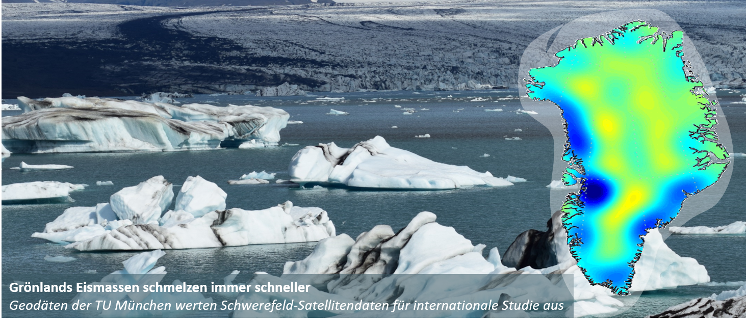
- GOCE’s view below the ice of Antarctica: Satellite gravimetry confirms improvements in Bedmap2 bedrock knowledge. Geophysical Research Letters 41 (14), 2014, 5021- 5028 more… BibTeX Full text ( DOI ) Full text (mediaTUM)
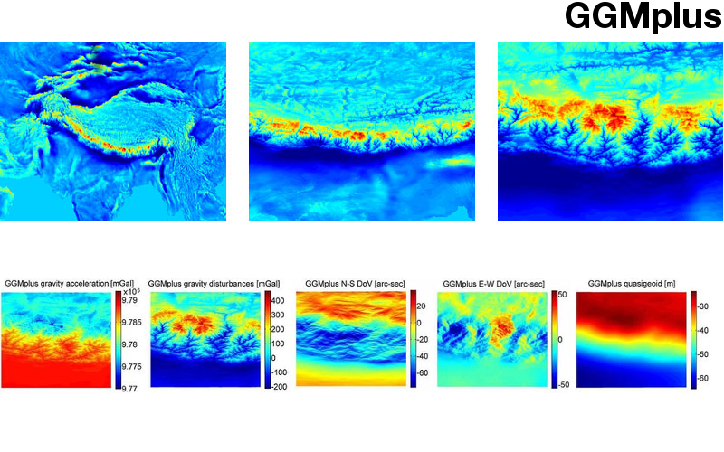
- Study of the Earth׳s short-scale gravity field using the ERTM2160 gravity model. Computers & Geosciences 73, 2014, 71-80 more… BibTeX Full text ( DOI ) Full text (mediaTUM)
- The adjoint method in geodynamics: derivation from a general operator formulation and application to the initial condition problem in a high resolution mantle circulation model. GEM - Int. J. Geomathematics 5 (2), 2014, 163--194 more… BibTeX Full text ( DOI )
- Multi-scale ionosphere model with data-adapted spatial resolution. 2014 XXXITH URSI General Assembly and Sciencifig Symposium (URSI GASS), 2014 more… BibTeX
- TWANGS High-Frequency Disturbing Signals in 10 Hz Accelerometer Data of the GRACE Satellites. , 2014 more… BibTeX
- Impact of non-conservative force modeling on GNSS satellite orbits and global solutions. , 2014 more… BibTeX
- Co-location of space geodetics techniques in Space and on the ground. In: , 2013 more… BibTeX
- Common Field-of-View of Cameras in Robotic Swarms. Proceedings of the 2013 IEEE/RSJ International Conference on Intelligent Robots and Systems (IROS-2013), 2013 more… BibTeX
- GNSS Based Signal Path Delay and Geodynamic Corrections for Centimeter Level Pixel Localization with TerraSAR-X. 2013 more… BibTeX
- Advanced High Resolution SAR Interferometry of Urban Areas with Airborne Millimetrewave Radar. PFG Photogrammetrie, Fernerkundung, Geoinformation Jahrgang 2013 Heft 6, 2013 more… BibTeX
- Recent snowfall anomalies in Dronning Maud Land, East Antarctica, in a historical and future climate perspective. Geophysical Research Letters, 2013 more… BibTeX Full text ( DOI )
- Global gravity field modeling based on GOCE and complementary gravity data. International Journal of Applied Earth Observation and Geoinformation, 2013 more… BibTeX Full text ( DOI )
- Center for Orbit Determination in Europe (CODE). Jet Propulsion Laboratory, 2013, more… BibTeX
- IGS-MGEX: Preparing the Ground for Multi-Constellation GNSS Science. 4th International Colloquium Scientific and Fundamental Aspects of the Galileo Programme, ESA, 2013 more… BibTeX
- Geodetic Observatory Wettzell - 20-m Radio Telescope and Twin Telescope. NASA Center for AeroSpace Information, 2013, more… BibTeX
- German Antarctic Receiving Station (GARS) O'Higgins. NASA Center for AeroSpace Information, 2013, more… BibTeX
- When "IVS Live" meets "e-RemoteCtrl" real-time data ... Finish Geodetic Institute, 2013, more… BibTeX
- Continuous Integration and quality control for scientific software. Finnish Geodetic Institute, 2013, more… BibTeX
- Co-location of space geodetics techniques in Space and on the ground. Finnish Geodetic Institute, 2013, more… BibTeX
- Impact of Different Observation Strategies on Reference Point Determination - Evaluations from a Campaign at the Geodetic Observatory Wettzell. Finnish Geodetic Institute, 2013, more… BibTeX
- On the Importance of Tima and Frequency in Geodesy. UFFC - EFTF Proceedings, 2013 more… BibTeX
- Examining ambient noise using colocated measurements of rotational and translational motion. J. Seismol, 2013 more… BibTeX Full text ( DOI )
Ingenieurinstitut für Astronomische und Physikalische Geodäsie
Das Ingenieurinstitut besteht aus:

Lehrstuhl für Astronomische und Physikalische Geodäsie
Univ.-Prof. Dr.techn. Mag.rer.nat. Roland Pail

Professur für Satellitengeodäsie
Univ.-Prof. Dr.phil.nat. Urs Hugentobler
Job offer in satellite navigation
The University of the Federal Armed Forces offers a PhD position at our geodetic research station in Wettzell.
For more information, you can check the PDF of the job offer..