IP1: Improved Tidal Dynamics and Uncertainty Estimation for Satellite Gravimetry (TIDUS)
PIs: Maik Thomas (FUB), Denise Dettmering (DGFI-TUM)
Personnel: Michael Hart-Davis (DGFI-TUM), Roman Sulzbach (FUB)
Research Objectives
- Quantify current ocean tide (OT) model uncertainties & impact on satellite gravimetry products
- Assess realistic errors for relevant OT constituents in different geographical regions
- Determine secondary ocean tide effects due to (i) minor tides, (ii) atmospheric tides, (iii) tidal loading
- Develop methods for achieving regional improvements of OT in critical regions
Innovations
- Statistical, region-dependent error assessment of OT
- Detailed investigation of secondary tide effects and tidal loading
Selected Results
In the first phase of the project, we focused on improving ocean tide modeling and deriving realistic error information for ocean tide models. IP1 provided uncertainty estimates, i.e., error covariance matrices, of present-day ocean tide models to the RU, in particular as input for IP2, IP4 and IP5 (cf. Figure 1 and Abrykosov et al., 2021).
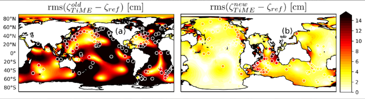
Moreover, the project focused on numerical developments of the Tidal Model forced by Ephemerides (TiME) shallow water code by introducing (i) rotated grids that avoid a singularity in the Arctic Ocean, (ii) explicit incorporation of the dynamic feedback from self-attraction and loading (in collaboration with IP2, Shihora et al., 2021) , (iii) the implementation of topographic wave drag as a new energy dissipation mechanism, and (iv) the objective derivation of global model bathymetries from high-resolution ocean depth charts. The sum of all those improvements reduced the open-ocean rms of the simulated M2 tide from more than 12 cm to 3.4 cm relative to the data- constrained tidal atlas FES14 (Sulzbach et al., 2021). Figure 2 shows the model improvement as quantified by M2 rms patterns before (a) and after (b) the model upgrades implemented in phase 1. Entailed by the substantial rms reduction and the now truly-global TiME model domain (including the entire Arctic Ocean and Antarctic ice-shelf cavities) the obtained tidal atlas serves as a valuable constraint for satellite gravimetry.
Benefiting from the improved model accuracy without data constraints, TiME simulations were conducted for a large ensemble of 50+ partial tides, explicitly including minor-amplitude constituents that can only be obtained with reduced precision with empirical approaches. Here it could be shown that a number of constituents, including tides at the edges of the tidal bands (e.g. OO1), radiationally excited tides (e.g. S1), and 3rd ocean tides (e.g. M3) can improve with the data-unconstrained approach.
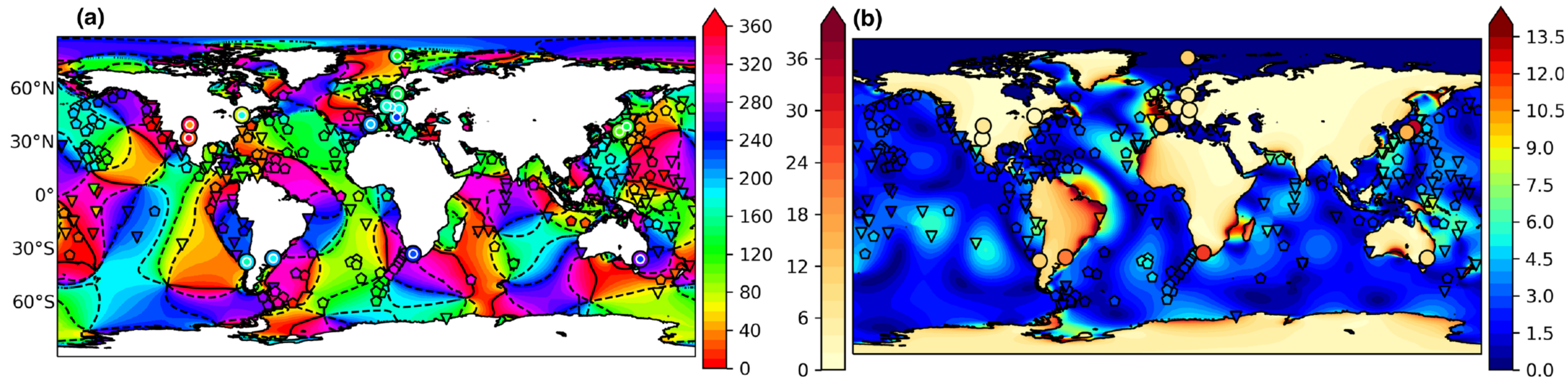
Furthermore, IP1 compiled a validation dataset of tidal constants (TICON) derived from globally distributed tide gauge stations (Piccioni et al., 2019). Recently, TICON has been extended to additionally allow for the assessment of ocean tides induced by the 3rd degree of the spherical harmonics expansion of the tidal potential (Dataset: Hart-Davis et al., 2022). The newly derived tidal constants were used to tune numerical simulations with TiME for those rarely simulated constituents. Additionally, tidal constituents from this subgroup were validated with gravimetric constituents derived from superconducting gravimeter time series confirming a high agreement with the modeled constituents (Sulzbach et al., 2022). Integrating measurements from tide gauge and superconducting gravimeter stations a dense global coverage is achieved, which confirms the accuracy of the conducted simulations (Figure 3).
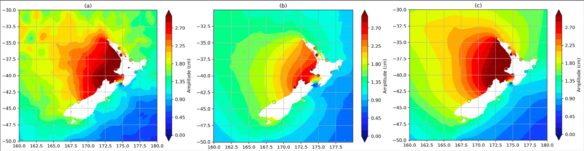
A strong focus of IP1 was on the proper estimation of minor tides from both empirical and numerical estimations. Regional experiments were run using EOT (Empirical Ocean Tide model) and were compared to the linear admittance estimations as well as the TiME and FES2014 tide models to determine the best strategy for minor tide estimations (Figure 4). The results provided an optimisation to the tidal correction strategy and provided the first look at merged approaches between empirical and hydrodynamic estimations (Hart-Davis et al., 2021b).
Regional studies of the EOT model also focused on the improvement of the tide model in the coastal and shelf region. In total, ten different critical regions were studied which were determined by identifying regions of complex coastlines, high standard deviation between existing tide models, and strong minor tide signals. These studies focused on the evaluation of several capsize techniques for the altimetry data, increasing the horizontal spatial resolution and the implementation of a coastal flag. The coastal flag was utilised to allow for the optimised use of satellite altimetry data in the near coastal regions which allowed for reliable data to be obtained from closer to the coast. All these regional studies provide suitable results for the development of EOT, which eventually fed into the development of the most recent global configuration, EOT20 (Hart-Davis et al., 2021a).