
Themen & Projekte
Von eigenen Satellitenmissionen bis hin zur Erforschung der Hyperloop-Technolgie – an dem Department Aerospace and Geodesy verfolgen Wissenschaftlerinnen und Wissenschaftler zahlreiche und vielversprechende Projekte über die unterschiedlichen Fachdisziplinen hinweg. Die Kernkompetenz sitzt dabei an unseren Lehrstühlen und Professuren, die in allen Teilgebieten der Luft- und Raumfahrt und der Geodäsie auf höchstem internationalen Niveau forschen. Besonders wichtig ist uns, dass unsere Forschung zur direkten Anwendung der Erkenntnisse und zur Integration verschiedener Technologien im Gesamtsystem führt. Praxisaffine Module in unseren Studiengängen und die Förderung von Unternehmergeist befördern studentische Initiativen und Innovation im Umfeld der Fakultät. Engagierte Studierende stemmen so ihre ganz eigenen Initiativen und machen sich in nationalen und internationalen Wettbewerben einen Namen.
Hyperloop: Transport in der Röhre made in Bavaria
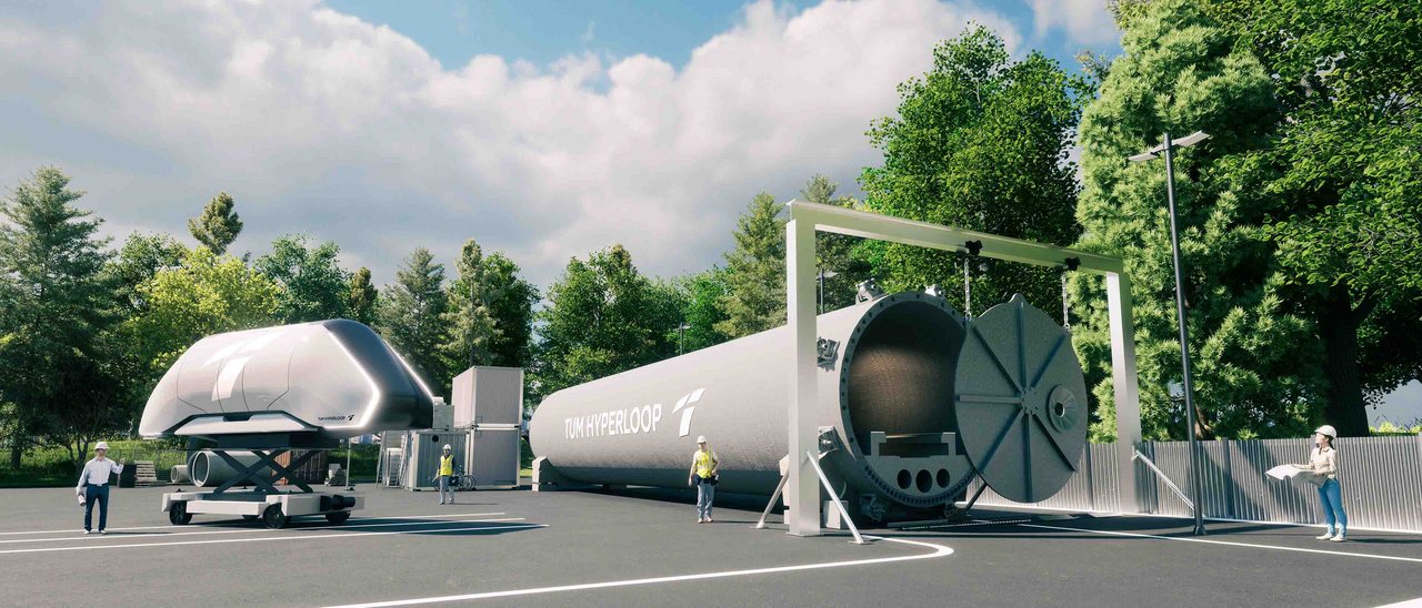
Ein Hochgeschwindigkeitszug, der sich mit annähernd Schallgeschwindigkeit durch eine Röhre bewegt: Was nach Science-Fiction klingt, wird in Bayern Wirklichkeit. Das TUM Hyperloop Programm wird sowohl die nötigen Technologien entwickeln und erproben als auch eine künftige technische und wirtschaftliche Machbarkeit systemanalytisch untersuchen. Angeregt durch die Leidenschaft der studentischen Initiative und gefördert von der Bayerischen Staatsregierung laufen seit dem Jahr 2018 am Department Aerospace and Geodesy Vorbereitungsarbeiten für ein großes, fächerübergreifendes Forschungsprogramm zum Thema Hyperloop. Viele Professuren und Lehrstühle aus den unterschiedlichsten Bereichen der Universität beteiligen sich am neuen TUM Hyperloop Programm. In dem hoch-interdisziplinären Forschungsgebiet kommen die vielen Kompetenzen der Exzellenzuniversität zusammen. Nach wie vor sind viele motivierte Studierende am Programm beteiligt, koordiniert durch den gemeinnützigen Verein NEXT Prototypes e.V.
2013 stellte Elon Musk in einem Whitepaper ein Konzept für ein bodengebundenes Hochgeschwindigkeits-Transportsystem vor: den sogenannten Hyperloop. Der Hyperloop besteht aus einer teilevakuierten Röhre, in der sich Kapseln zum Personen- und Gütertransport bewegen. Im Teilvakuum und durch die Nutzung eines kontaktlosen Schwebe- und Antriebsystems soll es möglich sein, Reisezeiten im Schienenverkehr deutlich zu reduzieren. Gleichzeitig ist der Hyperloop trotz schneller Reisezeit wesentlich umweltverträglicher als das Flugzeug. Die Veröffentlichung des Konzepts entfachte weltweit großes Interesse für neuartige, klimaneutrale Hochgeschwindigkeits-Transportsysteme.
"An der Technischen Universität München wird die Hyperloop-Vision Realität. Hier bringen wir das Fachwissen aus verschiedenen Fachgebieten zusammen wie der Antriebs- und Hochleistungstechnik, dem Leichtbau, dem Verkehrswegebau und der Ingenieurgeodäsie, um eine funktionierende und sichere Technologie für den Superschnellzug zu entwickeln. Dazu kommt der Pioniergeist, die Begeisterung und die unschätzbare Erfahrung des studentischen TUM Hyperloop Teams, das bereits mehrere Prototypen der Transportkapsel gebaut hat und viermal hintereinander als Geschwindigkeitsweltmeister siegreich aus der SpaceX Hyperloop Pod Competition in Los Angeles hervorgegangen ist. Die Fakultät für Luftfahrt, Raumfahrt und Geodäsie am Standort Ottobrunn/Taufkirchen ist der ideale Ort, um dieses Wissen gezielt weiterzuentwickeln und die Passion unserer jungen Talente für innovative Technologien der Zukunft zu fördern."
Prof. Thomas F. Hofmann, Präsident der TUM
Technologieentwicklung
In den Jahren 2020 bis 2022 wird ein Technologiedemonstrator in Originalgröße entwickelt und gebaut. Der Demonstrator soll aus einer 24 Meter langen Vakuumröhre sowie einer passenden Kapsel in Menschengröße bestehen. Die technische Umsetzung ist entscheidend für die Entwicklung eines künftigen Hyperloop-Systems. An dem Demonstrator sollen Integrations- und Funktionstests durchgeführt werden, um frühzeitig Problemstellungen zu erkennen und Lösungen zu erforschen, die technisch und ökonomisch sinnvoll sind. Darüber hinaus werden so experimentelle Daten gesammelt, die für die Konzeptanalyse genutzt werden können.
Konzeptanalyse
Parallel zur Entwicklung und Erprobung der Technologie sind die Modellierung und Analyse des erforschten Systems sowie dessen großmaßstäbliche Umsetzung notwendig. Damit werden verschiedene Konzepte auf technische und wirtschaftliche Machbarkeit überprüft und langfristig die Systemfähigkeit verbessert. Darüber hinaus werden frühzeitig mögliche Sicherheitsrisiken untersucht, erkannt und geeignete Maßnahmen erarbeitet. Aus diesen Untersuchungen sollen schließlich Vorschläge für geeignete Implementierungsmöglichkeiten in die bestehende Verkehrsinfrastruktur hervorgehen.
MOVE III: Studierende erforschen Weltraumschrott
Das Munich Orbital Verification Experiment, kurz MOVE, ist die Satellitentechnik-Gruppe des Studentischen Vereins WARR. Seit 15 Jahren ist es der zentrale Auftrag unseres Teams, Studierende mittels praktischer Erfahrung auszubilden und ihnen den Zugang zu einzigartigen Wissensquellen zu ermöglichen. Dazu entwickelt das Team eigens Satellitenhardware und erprobt diese im Weltraum mittels sogenannten CubeSats – einer standardisierten Variante von Nanosatellit. MOVE hat bereits drei 1U-CubeSats (Satelliten der Größe 10x10x11,3cm) in den Weltraum geschickt, und steht noch aktiv mit einem dieser Satelliten in Kontakt.
Darüber hinaus ermöglicht das MOVE-Projekt Studierenden an, durch Lehrstühle und externe Firmen bzw. Einrichtungen gestellten, Workshops teilzunehmen, mit dem Team und Doktoranden der Universität Publikationen zu veröffentlich und Forschungserfahrung zu sammeln.
Für weitere Informationen kontaktiere gerne das MOVE-Team unter satelliten@warr.de oder besuche unsere Webseite https://warr.de/projects/move/