

- Genauere Erdvermessung durch Satelliten. Die Umschau in Wissenschaft und Technik (17), 1964, 513-517 mehr… BibTeX
- Eine Karte 1:50000 des Testgebiets Renfrew. AVN - Allgemeine Vermessungs-Nachrichten 71 (11), 1964, 404 mehr… BibTeX
- Kritische Betrachtungen zu den Interferenzmessungen 1960 und 1961 mit dem Väisälä-Interferenzkomparator auf der Münchner Normalstrecke. Verlag der Bayerischen Akademie der Wissenschaften, 1963, mehr… BibTeX
- Geschichte und Bedeutung der Internationalen Erdmessung. Verlag der Bayerischen Akademie der Wissenschaften, 1963, mehr… BibTeX
- Kritische Betrachtung einiger Methoden zur Harmonischen Analyse von Erdgezeitenbeobachtungen. Verlag der Bayerischen Akademie der Wissenschaften, 1963, mehr… BibTeX
- Die Ausgleichung der Pendel- und Gravimetermessungen des europäischen Gravimetereichsystems. Verlag der Bayerischen Akademie der Wissenschaften, 1963, mehr… BibTeX
- Über eine neue numerische Lösung der I. geodätischen Hauptaufgabe auf einem Referenz-Rotationsellipsoid der Erde für Seitenlängen bis 120 km. Verlag der Bayerischen Akademie der Wissenschaften, 1963, mehr… BibTeX
- Das automatische Korrigieren optischer Systeme auf der Rechenanlage Zuse Z 11. Verlag der Bayerischen Akademie der Wissenschaften, 1963, mehr… BibTeX
- Tellurometermessungen der I. Abteilung des Deutschen Geodätischen Forschungsinstituts in den Jahren 1960 und 1961. Verlag der Bayerischen Akademie der Wissenschaften, 1963, mehr… BibTeX
- Frequenzprüfgeräte "ERICA" und "ERICH" für die Tellurometergeräte MRA 1(2) und Hydrodist. AVN - Allgemeine Vermessungs-Nachrichten 70 (3), 1963, 107-113 mehr… BibTeX
- Geodätische Astronomie und künstliche Erdsatelliten. In: Deutscher Landesbericht über die in den Jahren 1960 bis 1962 ausgeführten Arbeiten, DGK, Reihe B. Verlag der Bayerischen Akademie der Wissenschaften, 1963, 35-40 mehr… BibTeX
- Einige Bemerkungen zur Arbeit der Spezialstudiengruppe Nr. 22 in den Jahren 1961-1963. In: Deutsche Beiträge zur Vorlage bei der XIII. Generalversammlung der Internationalen Union für Geodäsie und Geophysik vom 19. bis 31. August 1963 in Berkeley/Kalifornien, DGK, Reihe B. Verlag der Bayerischen Akademie der Wissenschaften, 1963 mehr… BibTeX
- Leistung und Stand der elektronischen Entfernungsmessung. Vorträge beim IV. Internationalen Kurs für geodätische Streckenmessung 1961 in München II, DGK, Reihe B, Verlag des Instituts für Angewandte Geodäsie, 1963Mitteilungen aus dem Institut für Astronomische und Physikalische Geodäsie, Nr. 7 mehr… BibTeX
- Die elektronische Entfernungsmessung ist ein wichtiges Hilfsmittel der Geodäsie. 1962 mehr… BibTeX
- Beiträge zur Geodimetermessung. Verlag der Bayerischen Akademie der Wissenschaften, 1962, mehr… BibTeX
- Zehn Jahre I. Abteilung Deutsches Geodätisches Forschungsinstitut. AVN - Allgemeine Vermessungs-Nachrichten 69 (8), 1962, 272-280 mehr… BibTeX
- Beitrag zur Beobachtung und Ausgleichung kleiner Tellurometernetze. Compte Rendu du Premier Symposium International sur les Calculs Géodésiques, Académie Polonaise des Sciences, 1961 mehr… BibTeX
- Kurzer Bericht zur schrittweisen Ausgleichung des "REUN" nach dem Verfahren von Gauss-Vogler. Compte Rendu du Premier Symposium International sur les Calculs Géodésiques, Académie Polonaise des Sciences, 1961Mitteilungen aus dem Institut für Astronomische und Physikalische Geodäsie, Nr. 2 mehr… BibTeX
- Über die Beobachtung genauer astronomischer Längen. Verlag der Bayerischen Akademie der Wissenschaften, 1960, mehr… BibTeX
- Tellurometer measurements in the base extension network Munich. Journal of Geophysical Research 65 (2), 1960, 436-440 mehr… BibTeX Volltext ( DOI )
- Kritische Betrachtung zur Orientierung von geodätischen Hauptnetzen, günstigste Verteilung der Laplaceschen Punkte. Verlag der Bayerischen Akademie der Wissenschaften, 1956, mehr… BibTeX
- SRTM2gravity: an ultra-high resolution global model of gravimetric terrain corrections. Geophysical Research Letters 0 (ja) mehr… BibTeX Volltext ( DOI )
Ingenieurinstitut für Astronomische und Physikalische Geodäsie
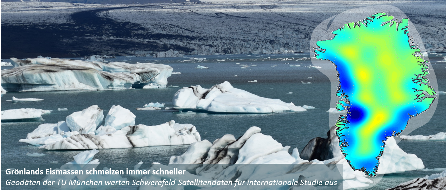
- Slide 1(Aktuelles Element)
- Slide 2
- Slide 3
- Slide 4
- Slide 5
Slide 1 von 5
Das Ingenieurinstitut besteht aus:

Lehrstuhl für Astronomische und Physikalische Geodäsie
Univ.-Prof. Dr.techn. Mag.rer.nat. Roland Pail

Professur für Satellitengeodäsie
Univ.-Prof. Dr.phil.nat. Urs Hugentobler