Datasets
We capture various study sites linked to our research and projects. This page features datasets that we make available via our viewer and in open data repositories…
Online Potree Viewer
Here we maintain an online Potree based web service to help you inspect our 3D datasets (Schütz, 2020).
Check out the viewer!
Multi-Temporal Multi-Source Point Clouds of Isar Riverbank near Wallgau
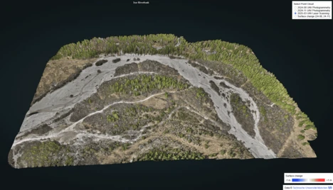
High-resolution 3D point clouds of a riverbank section along the Isar River near Wallgau, Germany. The data were acquired using UAV photogrammetry (UPH), UAV laser scanning (ULS) and terrestrial laser scanning (TLS), capturing detailed topographic features of the site. The dataset supports the analysis of fluvial dynamics, including sediment transport and channel morphology changes. Both the point clouds and the change map derived from the bi-temporal point clouds are accessible through our interactive viewer.
Check out the viewer.
Terrestrial and UAV Laser Scanning Point Clouds of TUM Campus Ottobrunn

3D point clouds acquired by terrestrial and UAV laser scanning (TLS and ULS) of the TUM Campus Ottobrunn main building of the Department of Aerospace and Geodesy, Technical University of Munich (TUM), Germany. A detailed documentation of data acquisition, basic processing, and supplementary data is provided in a metadata document for the TLS and ULS data, respectively. The dataset is part of the project TUM2TWIN (https://tum2t.win/), which provides highly detailed and accurate representations of the TUM campus.
Check out the dataset and viewer.
UAV Laser Scanning and Photogrammetry of TUM Downtown Campus
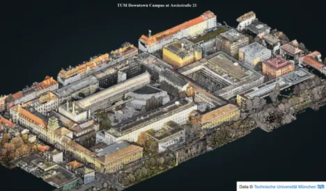
3D point clouds acquired by UAV laser scanning (ULS) and photogrammetry of the TUM Downtown campus, Technical University of Munich (TUM), Germany. A detailed documentation of data acquisition, basic processing, and supplementary data is provided in a metadata document. The dataset is part of the project TUM2TWIN (https://tum2t.win/), which provides highly detailed and accurate representations of the TUM campus.