Topics & Projects
The Figure shows the general outline and architecture of UPLIFT. In consistency with the respective fields of research, we structure the RTG into the topical project clusters (PC) I – V, each of which forms a figurative umbrella over individual projects with a similar scientific context.
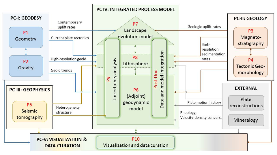
The central integrated process model (green; PC IV), which is composed of a geodynamic mantle model (P6) and a landscape evolution model (P7). With the Landlab toolkit, we will obtain full mechanical coupling between mantle flow and landscape evolution. Due to this novel approach, in a first step, we will focus on a direct coupling between P6 and P7 and the question of how the landscape model responds to uplift rates that are purely generated by mantle flow. Furthermore, in the first cohort we seek to identity the role of the lithosphere (P8) in the context of transferring uplift information being deduced from Earth’s mantle flow, to the surface. By this strategy, in a second step (second cohort) we intend to prepare a model-based approach for the lithosphere, by including an additional lithospheric model that forms a third coupling stage in the combined process model. In this final set-up, the lithospheric model will be able to provide a consistent crustal stress field that serves as additional physical constraint / boundary condition for the landscape evolution model.
All components of the integrated process model (PC IV) will be constrained by several types of observations (PCs I – III) on various spatial and temporal scales. Geodetic observations (PC I) quantify the actively changing Earth on contemporary timescales. Highly precise position and velocity determination at the Earth’s surface (P1) directly provides current vertical motion. The static and time-variable gravity field (P2) reflects the mass distribution and contemporary mass transport processes, respectively. In contrast, geomorphological, geochronological, stratigraphic and geological observations (PC II) provide information on the longer-term behavior on and close to the Earth’s surface, which will be gained by (a) systematically integrating published data on rates of uplift, erosion, and sedimentation, (b) acquiring new erosion and sedimentation rates at strategically selected sites (P3), and (c) building a geological model based on these data and the stratigraphic framework model developed to map dynamic topography in the geological record (P4). Both P3 and P4 require original field mapping and sampling of sedimentary rock suites dateable with magnetostratigraphy (P3) and thermo-chronology techniques (P4) to carry out provenance analysis which allows to tie P3, P4 through geomorphological modeling using the Landlab toolkit.
Geophysical information (PC III) derived from seismic tomography (P5) provides the most direct information on the present state of the Earth’s interior and will serve, together with the gravity field (P2), as first order parameter constraint in the geodynamic model. These data sets will also be used to revalidate the coupled geophysical model. External information on plate motion history and mineralogy, being essential input for the geodynamic model (P6), will be taken from literature.
The Post-Doc project focuses on the integration of all involved data set and the networking between all involved scientific fields. Here, key aspects will be data acquisition, data preparation, and analyses and modelling attempts under the view of the joint UPLIFT research objective. The post-doctoral researcher will support the knowledge transfer from cohort I to cohort II (end of year 3 of the RTG) of the doctoral researchers, since due to his/her integrative scientific role, he/she will build the links between all individual doctoral projects.
In parallel, PC V shall focus on the design of an interactive playground for simulation and visualization based on the virtual reality and visualization environment (‘cave’) at the LRZ (P10). The latter does not only have an important outreach component, but shall also support the understanding of processes across disciplines and will serve as a key component in bringing together the RTG participants from all disciplines.
For the subsequent cohorts of the RTG, the focus will gradually change towards interdisciplinary modelling and interpretation of uplift processes (second cohort, years 4-6), and, if positively evaluated and extended to a second phase of another 4.5 years, the use of complementary information to disentangle the three uplift modes (third cohort, years 7-9). Additionally, the scientific and societal impact and applications (natural hazards, landscape evolution, relative sea level, vulnerability & risk) shall be explored by cohorts 2 and 3. Summarized, over the course of the RTG, we expect a gradual shift in the topical focus from the ‘data’ PCs I to III to the integrative PCs IV to V.
The doctoral positions of the first phase will cover the following topics (supervisors in brackets):
- P1: Determination of contemporary uplift rates from geodetic observations (Prof. Urs Hugentobler, Prof. Xiaoxiang Zhu)
- P2: Interpretation of gravity and gravity changes in light of uplift processes (Prof. Roland Pail, Prof. Hans-Peter Bunge)
- P3: Magnetostratigraphy and geology of Cenozoic sections related to the Columbia River-Yellowstone plume system (Prof. Stuart Gilder, Prof. Anke Friedrich)
- P4: Sedimentologic, stratigraphic, and morpho-tectonic mapping of the western North American Cordillera bearing on its broad-scale uplift history (Prof. Anke Friedrich, Prof. Stuart Gilder)
- P5: Linking of seismic tomography and geodynamic Earth models (Prof. Heiner Igel, Dr. Bernhard Schuberth)
- P6: Adjoint geodynamic model enabled by high-performance computing (Prof. Hans-Peter Bunge, Prof. Dieter Kranzlmüller)
- P7: Transient landscape evolution through response models to plate and plume mode (Prof. Michael Krautblatter, Prof. Anke Friedrich)
- P8: The Lithospheric transfer function (Prof. Hans-Peter Bunge, Prof. Roland Pail)
- P9: Model adequacy under uncertainty (Prof. Barbara Wohlmuth, Dr. Laura Melas)
- P10: Curation of data for interactive visualization of the coupled dynamic Earth models (Prof. Dieter Kranzlmüller, Dr. Markus Wiedemann)
The Post-doc position performs an interdisciplinary and integrative role and covers the topic:
Data integration, model interfaces and knowledge transfer