Energy Atlas Berlin - The metropolitan area of Berlin as test site for the development and use of a Key Tool for Energy & Water Infrastructure Planning in Low-Carbon Cities
Cities are the key driver of resource consumption and global emissions. Thus it is necessary to optimize urban energy usage to support climate change mitigation. Energy Atlas comprehensively maps Berlin’s energy supply, usage and efficiency in order to allow stakeholders to explore where improvements could be made and where more renewable energy can be used.
Projektbeschreibung
The Climate Change Issue
Optimizing urban energy use and reducing city carbon emissions is crucial to climate mitigation. However city developers often lack sufficient tools or knowledge to be able to reasonably assess the low carbon options which are available to them when they carry out changes to the energy infrastructure. A road map towards low-emission and sustainable energy supply must incorporate integration strategies for renewable energy into new and existing supply units and infrastructure. In order to do this effectively decision makers require sufficient information to work in partnership with energy suppliers to implement necessary developments.
The Project Solution
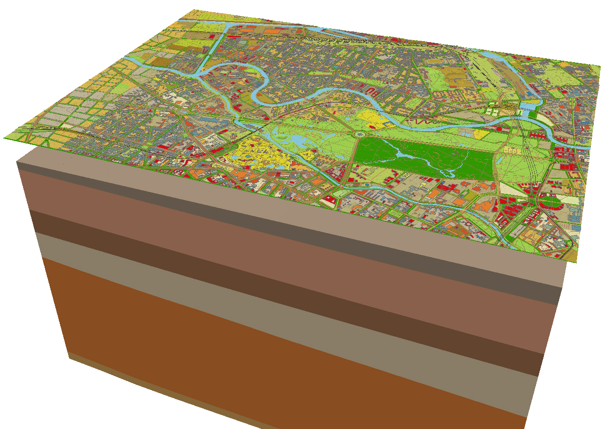
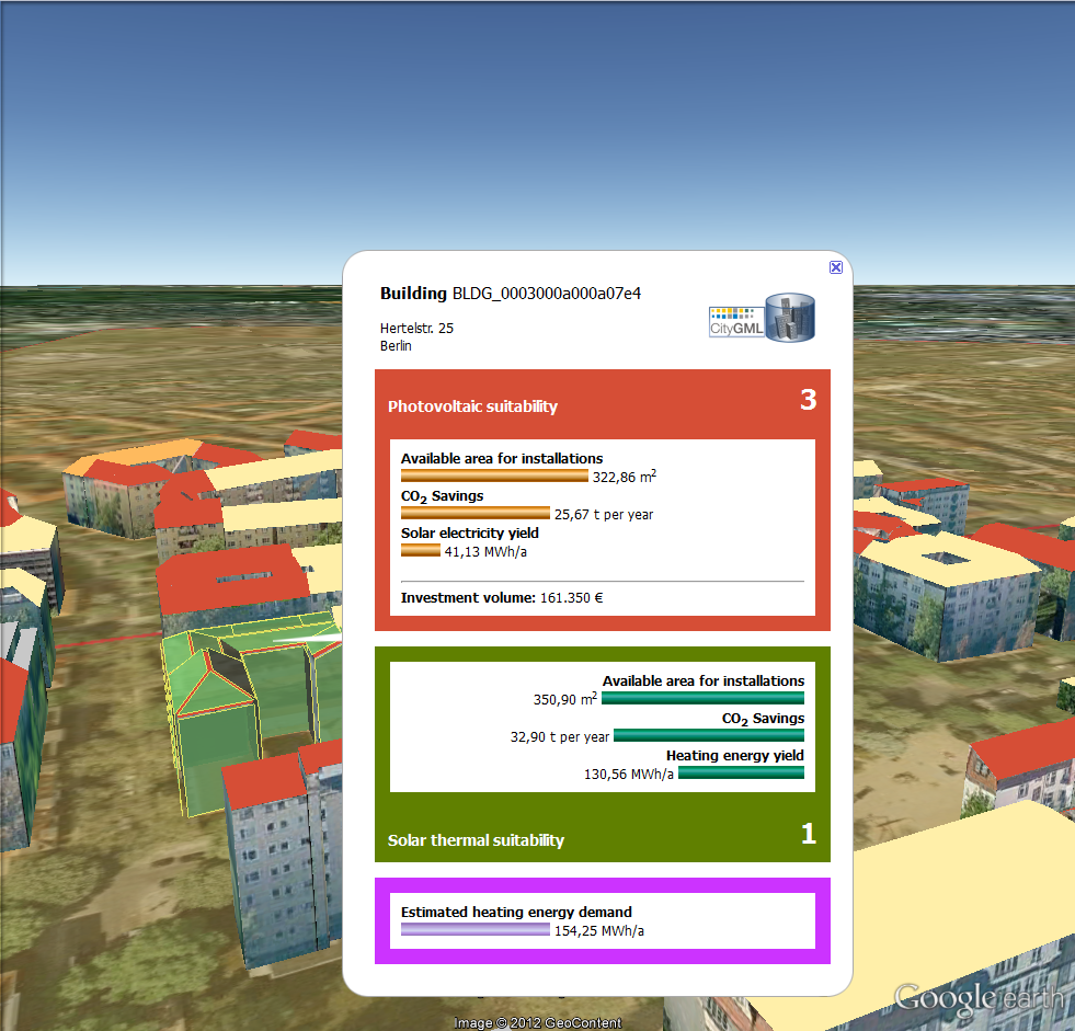
The Energy Atlas was developed as a tool for a holistic examination of energy consumption resp. energy demands, production and saving potentials at an urban and regional scale, focusing particularly on the incorporation of renewable energies. The project team have introduced a virtual 3D city model with a versatile multi-purpose toolset. The virtual 3D city model of Berlin serves as a common information hub, which contains more than 550,000 buildings structured regarding to the semantic data model of CityGML. The toolset integrates high resolution data on energy resources and infrastructure at a range of scales in the city. With sufficient relevant data the Energy Atlas can map the energy consumption and efficiency of buildings, existing power suppliers and network conditions in order to create an inventory of the urban energy usage. Besides mapping the existing energy usage, the Energy Atlas is used to apply a variety of analyses tools to estimate e.g. the energy demands, photovoltaic and geothermal potentials and optimal power grids and allows users to build scenarios correspondingly. Decision makers can use the model for intelligent urban management and energy infrastructure design. Transport, water and waste management are also be included into the Energy Atlas, allowing for a comprehensive tool for planning, designing and constructing sustainable energy systems in a city. The Energy Atlas model has been demonstrated using a case study of Berlin, looking particularly at issues such as geothermal energy, photovoltaic, transport, and building efficiency.
The role of the Climate-KIC network
The success of Energy Atlas is dependent on identifying reliable data and then integrating and linking them in a way which retains high levels of accuracy and comprehensibility for the users. The project partners have all worked together in order to ensure that this is the case. A number of departments from TUB worked to design the tool, carry out energy research and conduct simulations. BerP and SenWTF, as owners of the virtual 3D City Model of Berlin, respectively were crucial partner. GFZ and GASAG have carried out drilling in Berlin to estimate the potential of Berlin’s geothermal reservoirs. Likewise ChiWi and Vattenfall have both explored potential public and commercial applications for the Energy Atlas. Due to its exportability, the tool can be applied to cities beyond Berlin. The project already intends to add Potsdam (the capital city of Land Brandenburg) and the prototypical suburban region of Blankenfelde-Mahlow to the 3D model.
About Climate-KIC
Climate-KIC is an initiative of the European Institute of Innovation and Technology (EIT) with a mission to create sustainable growth by addressing climate change mitigation and adaptation. As Europe’s largest public-private innovation partnership we integrate education, entrepreneurship and innovation. By bringing together communities we help transform knowledge and ideas into economically viable products or services that help to mitigate climate change.
Zeitraum
2011-2013
Projektträger
Climate-KIC am European Institute of Innovation and Technology (EIT)
Willkomm, Philipp; Kaden, Robert; Coors, Volker; Kolbe, Thomas H. (Hrsg.): Leitfaden 3D-GIS und Energie. Runder Tisch GIS e.V., 2015 mehr…BibTeX
Nouvel, Romain; Bahu, Jean-Marie; Kaden, Robert; Kaempf, Jerome; Cipriano, Piergiorgio; Lauster, Moritz; Häfele, Karl-Heinz; Munoz, Esteban; Tournaire, Olivier; Casper, Egbert: Development of the CityGML Application Domain Extension Energy for Urban Energy Simulation. Building Simulation 2015 - 14th Conference of the International Building Performance Simulation Association, 2015, 559-564 mehr…BibTeX
Nouvel, Romain; Kaden, Robert; Bahu, Jean-Marie; Kaempf, Jerome; Cipriano, Piergiorgio; Lauster, Moritz; Benner, Joachim; Munoz, Esteban; Tournaire, Olivier; Casper, Egbert: Genesis of the CityGML Energy ADE. Proceedings of International Conference CISBAT 2015 on Future Buildings and Districts Sustainability from Nano to Urban Scale, LESO-PB, EPFL, 2015, 931-936 mehr…BibTeX
Steuer, Horst; Machl, Thomas; Sindram, Maximilian; Liebel, Lukas; Kolbe, Thomas H.: Voluminator - Approximating the Volume of 3D Buildings to Overcome Topological Errors. AGILE 2015 - Geographic Information Science as an Enabler of Smarter Cities and Communities (Lecture Notes in Geoinformation and Cartography), Springer, 2015Selected papers of the 18th AGILE Conference on Geographic Information Science, 343-362 mehr…BibTeX
2014
Casper, Egbert; Häfele, Karl-Heinz; Kaden, Robert: OGC standard CityGML opens up new applications in energy simulation. Journal of the National Institute of Building Sciences 2 (6), 2014, 30-32 mehr…BibTeX
Kaden, Robert; Kolbe, Thomas H.: Simulation-Based Total Energy Demand Estimation of Buildings using Semantic 3D City Models. International Journal of 3-D Information Modeling 3 (2), 2014, 35-53 mehr…BibTeX
Offer, Julia; Kaden, Robert; Kastner, Oliver; Zimmermann, Günter; Kolbe, Thomas H.: Entwicklung eines GIS-Werkzeugs zur Untersuchung geothermischer Energieproduktionspotenziale. Angewandte Geoinformatik 2014, Wichmann Verlag, 2014Tagungsband zur Konferenz AGIT 2014, 127-136 mehr…BibTeX
Yao, Zhihang; Kolbe, Thomas H.: Cloud-basierter Webclient für kollaboratives Arbeiten auf semantischen 3D-Stadtmodellen. Geoinformationen öffnen das Tor zur Welt, 34. Wissenschaftlich-Technische Jahrestagung der DGPF (Publikationen der Deutschen Gesellschaft für Photogrammetrie, Fernerkundung, Geoinformation e.V.), Deutsche Gesellschaft für Photogrammetrie, Fernerkundung, Geoinformation e.V., 2014 mehr…BibTeX
Yao, Zhihang; Sindram, Maximilian; Kaden, Robert; Kolbe, Thomas H.: Cloud-basierter 3D-Webclient zur kollaborativen Planung energetischer Maßnahmen am Beispiel von Berlin und London. In: Kolbe, Thomas H.; Bill, Ralf; Donaubauer, Andreas (Hrsg.): Geoinformationssysteme 2014. Wichmann, 2014 mehr…BibTeX
2013
Banfi, Daniel: Energiebedarfsanalyse urbaner Räume anhand des semantischen Modells und Austauschformats CityGML. Masterarbeit, 2013 mehr…BibTeX
Biernath, Felix: Berechnung der Wärmeenergiebedarfe von Gebäuden und deren Validierung anhand tatsächlicher Verbrauchsdaten. Bachelorarbeit, 2013 mehr…BibTeX
Kaden, Robert; Kolbe, Thomas H.: City-Wide Total Energy Demand Estimation of Buildings using Semantic 3D City Models and Statistical Data. Proc. of the 8th International 3D GeoInfo Conference, 2013 mehr…BibTeX
Kaden, Robert; Nagel, Claus; Herreruela, Javier; Kolbe, Thomas H.: Kopplung von 3D-Stadtmodellen mit Cloud-Diensten. Neue Horizonte für Geodateninfrastrukturen – Open GeoData, Mobility, 3D-Stadt, 2013 mehr…BibTeX
Kaden, Robert; Prytula, Michael; Krüger, Andreas; Kolbe, Thomas H.: Energieatlas Berlin: Vom Gebäude zur Stadt – Am Beispiel zur Abschätzung der Wärmeenergiebedarfe von Gebäuden. Geoinformationssysteme 2013 - Beiträge zum 18. Münchner Fortbildungsseminar Geoinformationssysteme, 2013, 17-32 mehr…BibTeX
Kastner, Oliver; Huenges, Ernst; Bredel-Schürmann, Stefan; Kolbe, Thomas H.; Kabus, Frank: Geothermische Wärmeversorgung von Metropolen aus dem Tiefengestein am Beispiel Berlins. Zusammenarbeit von Forschung und Wirtschaft für Erneuerbare Energien und Energieeffizienz - Beiträge zur FVEE-Jahrestagung 2012, ForschungsVerbund Erneuerbare Energie (FVEE), 2013 mehr…BibTeX
2012
Kaden, Robert; Krüger, Andreas; Kolbe, Thomas H.: Energy Atlas Berlin. 2012 mehr…BibTeX
Kaden, Robert; Krüger, Andreas; Kolbe, Thomas H.: Integratives Entscheidungswerkzeug für die ganzheitliche Planung in Städten auf der Basis von semantischen 3D-Stadtmodellen am Beispiel des Energieatlasses Berlin. Tagungsband der Wissenschaftlich-Technischen Jahrestagung der Deutschen Gesellschaft für Photogrammetrie, Fernerkundung und Geoinformation (DGPF) in Potsdam, 2012 (Publikationen der Deutschen Gesellschaft für Photogrammetrie, Fernerkundung und Geoinformation (DGPF) e.V.), 2012 mehr…BibTeX
Krüger, Andreas; Kolbe, Thomas H.: Building Analysis for Urban Energy Planning Using Key Indicators on Virtual 3D City Models: The Energy Atlas of Berlin. Proceedings of the ISPRS Congress 2012 in Melbourne (ISPRS International Archives of the Photogrammetry, Remote Sensing and Spatial Information Sciences), ISPRS, 2012 mehr…BibTeX
2010
Carrión, Daniel; Lorenz, Alexandra; Kolbe, Thomas H.: Estimation of the energetic rehabilitation state of buildings for the city of Berlin using a 3D city model represented in CityGML. ISPRS Conference: International Conference on 3D Geoinformation. XXXVIII-4, ISPRS, 2010 mehr…BibTeX