Featured Papers

GlobalBuildingAtlas: an open global and complete dataset of building polygons, heights and LoD1 3D models
We introduce GlobalBuildingAtlas, a publicly available dataset providing global and complete coverage of building polygons, heights and Level of Detail 1 (LoD1) 3D building models. This is the first open dataset to offer high quality, consistent, and complete building data in 2D and 3D form at the individual building level on a global scale. Towards this dataset, we developed machine learning-based pipelines to derive building polygons and heights (called GBA.Height) from global PlanetScope satellite data, respectively. Also a quality-based fusion strategy was employed to generate higher-quality polygons (called GBA.Polygon) based on existing open building polygons, including our own derived one. With more than 2.75 billion buildings worldwide, GBA.Polygon surpasses the most comprehensive database to date by more than 1 billion buildings. GBA.Height offers the most detailed and accurate global 3D building height maps to date, achieving a spatial resolution of 3 m × 3 m – 30 times finer than previous global products (90 m), enabling a high-resolution and reliable analysis of building volumes at both local and global scales. Finally, we generated a global LoD1 building model (called GBA.LoD1) from the resulting GBA.Polygon and GBA.Height. GBA.LoD1 represents the first complete global LoD1 building models, including 2.68 billion building instances with predicted heights, i.e., with a height completeness of more than 97 %, achieving RMSEs ranging from 1.5 to 8.9 m across different continents. With its height accuracy, comprehensive global coverage and rich spatial details, GlobalBuildingAtlas offers novel insights on the status quo of global buildings, which unlocks unprecedented geospatial analysis possibilities, as showcased by a better illustration of where people live and a more comprehensive monitoring of the progress on the 11th Sustainable Development Goal of the United Nations. The code is publicly available at https://github.com/zhu-xlab/GlobalBuildingAtlas (last access: 1 November 2025). The GBA dataset described in this manuscript can be accessed on mediaTUM under https://doi.org/10.14459/2025mp1782307 (Zhu et al., 2025b).
Reference: Xiao Xiang Zhu, Sining Chen, Fahong Zhang, Yilei Shi, Yuanyuan Wang (2025). GlobalBuildingAtlas: An Open Global and Complete Dataset of Building Polygons, Heights and LoD1 3D Models. Earth System Science Data, 17. (link)

Unsupervised detection of building destruction during war from publicly available radar satellite imagery
Automated detection of building destruction in conflict zones is crucial for human rights monitoring, humanitarian response, and academic research. However, existing approaches 1) rely on proprietary satellite imagery, both expensive and of limited availability at wartime, 2) require labeled training data, usually not available in war-affected regions, or 3) use optical imagery, regularly obstructed by cloud cover. This study addresses these challenges by introducing an unsupervised method to detect destruction at the building level using freely and globally available Sentinel-1 synthetic aperture radar (SAR) images from the European Space Agency (ESA). By statistically assessing interferometric coherence changes over time, unlike existing approaches, our method enables the detection of destruction from a single satellite image, allowing for near real-time destruction assessments every 12 days. We provide a continuous, statistically grounded probability measure for the likelihood of destruction at both the building and pixel level, thereby quantifying the level of uncertainty of the detection. Using open-access data, our method offers a scalable, global, and cost-effective solution for monitoring building destruction in conflict zones.
Reference: Daniel Racek, Qi Zhang, Paul W. Thurner, Xiao Xiang Zhu, Göran Kauermann (2025). Unsupervised Detection of Building Destruction during War from Publicly Available Radar Satellite Imagery. PNAS Nexus, 4. (link)
Books
| 1. | Adam J. Stewart, Caleb Robinson, Arindam Banerjee (2025). Geospatial Machine Learning Libraries, , 2025. (link) |
| 2. | Gustau Camps-Valls, Devis Tuia, Xiao Xiang Zhu, Markus Reichstein (Editors) (2021). Deep learning for the Earth Sciences: A comprehensive approach to remote sensing, climate science and geosciences, Wiley & Sons, 2021. (link) |
| 3. | Johannes Brinkmann, Mrinalini Kochupillai (2020). Law, Business, and Legitimacy, Springer International Publishing, 2020. (link) |
Journal Papers
| 1. | Naomi Simumba, Nils Lehmann, Paolo Fraccaro, Hamed Alemohammad, Geeth De Mel, Salman Khan, Manil Maskey, Nicolas Longepe, Xiao Xiang Zhu, Hannah Kerner, Juan Bernabe-Moreno, Alexandre Lacoste (2026). GEO-Bench-2: From Performance to Capability, Rethinking Evaluation in Geospatial AI. Transactions on Machine Learning Research, in press. |
| 2. | Konstantin Klemmer, Esther Rolf, Marc Ru\sswurm and Gustau Camps-Valls, Mikolaj Czerkawski, Stefano Ermon and Alistair Francis, Nathan Jacobs, Hannah Kerner and Lester Mackey, Gengchen Mai, Oisin Mac Aodha and Markus Reichstein, Caleb Robinson, David Rolnick and Evan Shelhamer, Vincent Sitzmann, Devis Tuia and Xiao Xiang Zhu (2026). Earth Embeddings: Towards AI-Centric Representations of Our Planet. IEEE Geoscience and Remote Sensing Magazine, in press. |
| 3. | Fan Fan, Yilei Shi, Tobias Guggemos, Xiao Xiang Zhu (2026). Multitask Learning for Earth Observation Data Classification with Hybrid Quantum Network. Quantum Machine Intelligence, in press. |
| 4. | Jeremy Eudaric, Marleen C. de Ruiter, Nivedita Sairam, Andrés Camero, Kasra Rafiezadeh Shahi, Mark W. Smith, Xiao Xiang Zhu, Heidi Kreibich (2026). Geospatial Mapping of Malaria Risk in Flood-Prone Zones of Sub-Saharan Africa. Scientific Reports, in press. |
| 5. | Le Dong, Yang An, Weisheng Dong, Zhenyu Wang, Lichao Mou (2026). Low-Light Remote Sensing Image Enhancement Guided Collaboratively by Memory and Illumination Map. IEEE Geoscience and Remote Sensing Letters, 23, pp. 1–5. (link) |
| 6. | Chenying Liu, Wei Huang, Xiao Xiang Zhu (2026). LandSegmenter: Towards a Flexible Foundation Model for Land Use and Land Cover Mapping. ISPRS Journal of Photogrammetry and Remote Sensing, in press. |
| 7. | Weikang Yu, Vincent Nwazelibe, Xianping Ma, Xiaokang Zhang, Richard Gloaguen, Xiao Xiang Zhu, Pedram Ghamisi (2026). EuroMineNet: A Multitemporal Sentinel-2 Benchmark for Spatiotemporal Mining Footprint Analysis in the European Union (2015–2024). ISPRS Journal of Photogrammetry and Remote Sensing, in press. |
| 8. | Shanwen Wang, Xin Sun, Jungong Han, Xiao Xiang Zhu (2026). RSCLIP for Training-Free Open-Vocabulary Remote Sensing Image Semantic Segmentation. IEEE Journal of Selected Topics in Applied Earth Observations and Remote Sensing, in press. |
| 9. | Sining Chen, Yilei Shi, Xiao Xiang Zhu (2026). Enhancing Monocular Building Height Estimation via Weak Supervision from Imperfect Labels. IEEE Journal of Selected Topics in Applied Earth Observations and Remote Sensing, in press. |
| 10. | Nora Gourmelon, Konrad Heidler, Erik Loebel, Daniel Cheng, Julian Klink, Anda Dong, Fei Wu, Noah Maul, Moritz Koch, Marcel Dreier, Dakota Pyles, Thorsten Seehaus, Matthias Braun, Andreas Maier, Vincent Christlein (2026). Comparison Study: Glacier Calving Front Delineation in Synthetic Aperture Radar Images With Deep Learning. IEEE Transactions on Pattern Analysis and Machine Intelligence, pp. 1-8. (link) |
| 11. | D. H. Nong, T. S. Ngo, T. T. Phuong and Michael Garschagen, Andrea Reimuth (2026). Linking Remote Sensing and Demographic Data to Study Urbanization: A Case Study of Hanoi Urban Districts. Urban Morphology, in press. |
| 12. | Alessandro Sebastianelli, Francesco Mauro, Amer Delilbasic and Pietro Di Stasio, Fan Fan, Gabriele Meoni and Gabriele Cavallaro, Xiao Xiang Zhu, Paolo Gamba and Silvia Ullo (2026). Quantum Machine Learning for Earth Observation: A Review and Future Prospects. IEEE Geoscience and Remote Sensing Magazine, in press. |
| 13. | Shan Zhao, Ioannis Prapas, Zhitong Xiong, Ilektra Karasante, Ioannis Papoutsis, Gustau Camps-Valls, Xiao Xiang Zhu (2026). Causal Graph Neural Networks for Robust Wildfire Forecasting Across Geographic Shifts. ISPRS Journal of Photogrammetry and Remote Sensing, in press. |
| 14. | Stella Ofori-Ampofo, Antony Zappacosta, Ridvan Salih Kuzu, Peter Schauer, Martin Willberg, Xiao Xiang Zhu (2026). Assessing Cocoa Landuse Change and Exposure to Artisanal and Small-Scale Gold Mining Using Satellite Imagery. IEEE Journal of Selected Topics in Applied Earth Observations and Remote Sensing, in press. |
| 15. | Mansour Mehranfar, Alexander Braun, André Borrmann, Medhini Heeramaglore, Thomas H. Kolbe, Zhaiyu Chen, Xiao Xiang Zhu (2026). Automatic Alignment of Semantic Building Models with Digital City Models Through Multi-Level Point Cloud Semantic Segmentation and Registration Using PSO Optimization: A Case Study of the TUM Main Campus. International Journal of Applied Earth Observation and Geoinformation, in press. |
| 16. | Chenying Liu, Gianmarco Perantoni, Lorenzo Bruzzone, Xiao Xiang Zhu (2026). Adaptive Gradient Calibration for Single-Positive Multi-Label Learning in Remote Sensing Image Scene Classification. IEEE Transactions on Geoscience and Remote Sensing, in press. |
| 17. | Yang Mu, Zhitong Xiong, Yi Wang, Muhammad Shahzad, Franz Essl, Holger Kreft, Mark van Kleunen, Xiao Xiang Zhu (2026). GlobalGeoTree: A Multi-Granular Vision-Language Dataset for Global Tree Species Classification. Earth System Science Data (link) |
| 18. | Adrian Höhl, Stella Ofori-Ampofo and Miguel-Ángel Fernández-Torres and R\idvan Salih Kuzu, Xiao Xiang Zhu (2026). A Large-Scale, Multitask, Multisensory Dataset for Climate-Aware Crop Monitoring in the US from 2018–2022. Scientific Data, 13. (link) |
| 19. | Xiao Xiang Zhu, Qingyu Li, Yilei Shi, Yuanyuan Wang, Adam J. Stewart, Jonathan Prexl (2026). GlobalBuildingMap: Unveiling the Mystery of Global Buildings. Scientific Data, 13. (link) |
| 20. | Xiao Xiang Zhu, Zhitong Xiong, Yi Wang, Adam J. Stewart, Konrad Heidler, Yuanyuan Wang, Zhenghang Yuan, Thomas Dujardin, Qingsong Xu, Yilei Shi (2026). On the Foundations of Earth Foundation Models. Communications Earth & Environment, in press. (link) |
| 21. | Angelos Zavras, Dimitrios Michail, Xiao Xiang Zhu and Begüm Demir, Ioannis Papoutsis (2026). GAIA: A Global, Multi-Modal, Multi-Scale Vision-Language Dataset for Remote Sensing Image Analysis. IEEE Geoscience and Remote Sensing Magazine, in press. |
| 22. | Jing He, Liupeng Lin, Zhuo Zheng, Qiangqiang Yuan, Jie Li, Liangpei Zhang, Xiao Xiang Zhu (2026). Spatial-X Fusion for Multi-Source Satellite Imageries. Remote Sensing of Environment, 334. (link) |
| 23. | Jing He, Xiao Xiang Zhu (2026). Reverse Degradation for Remote Sensing Pan-Sharpening. International Journal of Applied Earth Observation and Geoinformation, 146. (link) |
| 24. | Olaf Wysocki, Benedikt Schwab, Manoj Kumar Biswanath and Michael Greza, Qilin Zhang, Jingwei Zhu, Thomas Froech and Medhini Heeramaglore, Ihab Hijazi, Khaoula Kanna and Mathias Pechinger, Zhaiyu Chen, Yao Sun and Alejandro Rueda Segura, Ziyang Xu, Omar AbdelGafar and Mansour Mehranfar, Chandan Yeshwanth, Yueh-Cheng Liu and Hadi Yazdi, Jiapan Wang, Stefan Auer and Katharina Anders, Klaus Bogenberger, Andre Borrmann and Angela Dai, Ludwig Hoegner, Christoph Holst and Thomas H. Kolbe, Ferdinand Ludwig, Matthias Nie\ssner and Frank Petzold, Xiao Xiang Zhu, Boris Jutzi (2026). TUM2TWIN: Introducing the Large-Scale Multimodal Urban Digital Twin Benchmark Dataset. ISPRS Journal of Photogrammetry and Remote Sensing, 232. (link) |
| 25. | Yao Sun, Liqiu Meng, Andrés Camero Unzueta, Stefan Auer, Xiao Xiang Zhu (2026). A Deep Dive into OpenStreetMap Research Since its Inception (2008–2024): Contributors, Topics, and Future Trends. International Journal of Geographical Information Science, in press. |
| 26. | Zhaiyu Chen, Yi Wang, Yilei Shi, Xiao Xiang Zhu (2026). Reconstructing Building Height from Spaceborne TomoSAR Point Clouds Using a Dual-Topology Network. IEEE Transactions on Geoscience and Remote Sensing, in press. (link) |
| 27. | Bertil Nlend, Andrea Reimuth, Liang Emlyn Yang and Mahesh Jampani, Elena Cristiano, Benjamin Dewals and Elizabeth Boyer, Irem Daloglu Cetinkaya and Laurent Pascal Diémé, Ratnadeep Dutta and Wenhan Feng, Giovanna Grossi, Wassef Ben Nasr and Olabisi S. Obaitor, Adeyemi Oludapo Olusola and Anandharuban Panchanathan, Gerhard Rab and Sanjib Sharma, Chenghao Wang and Maria Magdalena Warter, Claire Welty and Doerthe Tetzlaff (2025). Building Resilient Urban Water Systems: Emerging Opportunities for Solving Long-Lasting Challenges. Hydrological Sciences Journal, 70(12), pp. 2003–2015. (link) |
| 28. | Lena Scheiber, Viktoria Zühlsdorff and Dunong Huu Nong, Thanh Son Ngo, Nigel K. Downes and Felix Bachofer, Hong Quan Nguyen, Matthias Garschagen, Andrea Reimuth (2025). Monitoring Urban Green Space for Climate-Resilient Development in the Face of Rapid Urbanization: A Tale of Two Vietnamese Cities. Remote Sensing Applications: Society and Environment pp. 101820. (link) |
| 29. | Nicolas Longépé, Hamed Alemohammad, Anca Anghelea, Thomas Brunschwiler, Gustau Camps-Valls, Gabriele Cavallaro, Jocelyn Chanussot, Jose Manuel Delgado, Begüm Demir, Nikolaos Dionelis, Paolo Fraccaro, Anna Jungbluth, Robert E. Kennedy, Valerio Marsocci, Muthukumaran Ramasubramanian, Raul Ramos-Pollan, Sujit Roy, Gencer Sümbül, Devis Tuia, Xiao Xiang Zhu, Rahul Ramachandran (2025). Earth Action in Transition: Highlights From the 2025 ESA–NASA International Workshop on AI Foundation Models for EO [Space-Agencies]. IEEE Geoscience and Remote Sensing Magazine, 13(4), pp. 457-462. (link) |
| 30. | Zhenghang Yuan, Zhitong Xiong, Thomas Dujardin, Xiang Li, Lichao Mou, Xiao Xiang Zhu (2025). ChatEarthBench: Benchmarking Multimodal Large Language Models for Earth Observation. IEEE Geoscience and Remote Sensing Magazine, in press. |
| 31. | Yue Zeng, Jianhua Guo, Xiao Xiang Zhu (2025). Enhancing the Understanding of Urban Green Space Cooling Effects in China’s Major Cities with a Sub-Meter Dataset. Sustainable Cities and Society, 136. (link) |
| 32. | Wei Huang, Yilei Shi, Zhitong Xiong, Xiao Xiang Zhu (2025). Height-Assisted Semi-Supervised Building Footprint Extraction from Optical Remote Sensing Images. IEEE Transactions on Geoscience and Remote Sensing, 63. (link) |
| 33. | Codruț-Andrei Diaconu, Harry Zekollari, Jonathan L. Bamber (2025). DL4GAM: A Multi-Modal Deep Learning-Based Framework for Glacier Area Monitoring, Trained and Validated on the European Alps. Earth and Space Science, 12(9), pp. e2025EA004197. (link) |
| 34. | Sindhu Ramanath, Lukas Krieger, Dana Floricioiu, Codruț-Andrei Diaconu, Konrad Heidler (2025). Automatic Grounding Line Delineation of DInSAR Interferograms Using Deep Learning. The Cryosphere, 19(7), pp. 2431–2455. (link) |
| 35. | Thomas Stark, Michael Wurm, Henri Debray, Xiao Xiang Zhu, Hannes Taubenböck (2025). Uncertainty Aware Slum Mapping in 55 Heterogeneous Cities. International Journal of Applied Earth Observation and Geoinformation, 145. (link) |
| 36. | Paul Höhn, Konrad Heidler, Robert Behling, Xiao Xiang Zhu (2025). A Spatio-Temporal Dataset for Satellite-Based Landslide Detection. Scientific Data, 12, pp. 1772. (link) |
| 37. | Daniel Racek, Qi Zhang, Paul W. Thurner, Xiao Xiang Zhu, Göran Kauermann (2025). Unsupervised Detection of Building Destruction during War from Publicly Available Radar Satellite Imagery. PNAS Nexus, 4. (link) |
| 38. | Wolfgang Wagner, Bernhard Bauer-Marschallinger, Florian Roth, Tobias Raiger-Stachl, Christoph Reimer, Niall McCormick, Patrick Matgen, Marco Chini, Yu Li, Sandro Martinis, Marc Wieland, Franziska Kraft, Davide Festa, Muhammed Hassaan, Mark Edwin Tupas, Jie Zhao, Michaela Seewald, Michael Riffler, Luca Molini, Richard Kidd, Christian Briese, Peter Salamon (2026). The fully-automatic Sentinel-1 Global Flood Monitoring service: Scientific challenges and future directions. Remote Sensing of Environment, 333. (link) |
| 39. | Stella Ofori-Ampofo, Ridvan Salih Kuzu, Peter Schauer, Martin Willberg, Adrian Höhl, Xiao Xiang Zhu (2025). On the strategy of exploring spatio-temporal information from Earth observation data for crop yield prediction. Smart Agricultural Technology, 12, pp. 101540. (link) |
| 40. | Qingyu Li, Genyu Xu, Ziqi Gu (2025). Deep learning and remote sensing for scalable building age prediction in urban energy modeling. Energy and Buildings, 37. (link) |
| 41. | Xiao Xiang Zhu, Sining Chen, Fahong Zhang, Yilei Shi, Yuanyuan Wang (2025). GlobalBuildingAtlas: An Open Global and Complete Dataset of Building Polygons, Heights and LoD1 3D Models. Earth System Science Data, 17. (link) |
| 42. | Maximilian Zachow, Stella Ofori-Ampofo, Harald Kunstmann, Rıdvan Salih Kuzu, Xiao Xiang Zhu, Senthold Asseng (2025). Wheat yield forecasts with seasonal climate models and long short-term memory networks. Computers and Electronics in Agriculture, 239. (link) |
| 43. | Qingsong Xu, Yilei Shi, Jonathan Bamber, Ye Tuo, Ralf Ludwig, Xiao Xiang Zhu (2025). Physics-aware machine learning revolutionizes scientific paradigm for process-based modeling in hydrology. Earth-Science Reviews, 271. (link) |
| 44. | Fahong Zhang, Yilei Shi, Xiao Xiang Zhu (2025). Global Collinearity-aware Polygonizer for Polygonal Building Mapping in Remote Sensing. IEEE Trans. on Geoscience and Remote Sensing, 63. (link) |
| 45. | Bing Liu, Xiao Xiang Zhu, Qiqi Ding, Pinjian Li, Haojun Xi, Tianhong, Huihuang Luo (2025). Integrated Retrieval of Water Quality Parameters using UAV Hyperspectral Images and Satellite Imagery: Leveraging Deep Learning and Attention Mechanisms for Precision. Ecological Indicators, 179. (link) |
| 46. | Enno Tiemann, Shanyu Zhou, Alexander Kl¨aser, Konrad Heidler, Rochelle Schneider, Xiao Xiang Zhu (2025). Machine Learning for Methane Detection and Quantification from Space - A survey. IEEE Geoscience and Remote Sensing Magazine, Early access. (link) |
| 47. | Henri Debray, Richard Lemoine-Rodriguez, Michael Wurm, Xiao Xiang Zhu, Hannes Taubenböck (2025). Distributions of types of urban fabrics around the world: Beyond narratives of global regularities and local specificities. Applied Geography, 184. (link) |
| 48. | Katharina Hechinger, Christoph Schweden, Xiao Xiang Zhu, Göran Kauermann (2025). Human-in-the-Loop: Towards Label Embeddings for Assessing Classification Difficulty. Statistical Modelling. (link) |
| 49. | Xizhe Xue, Xiao Xiang Zhu (2025). Regression in Earth Observation: Are vision–language models up to the challenge?. IEEE Geoscience and Remote Sensing Magazine, Early access. (link) |
| 50. | Daixin Zhao, Konrad Heidler, Milad Asgarimehr, Conrad M. Albrecht, Jens Wickert, Xiao Xiang Zhu, Lichao Mou (2025). Multimodal GNSS-R self-supervised learning as a generalist Earth surface monitor. International Journal of Applied Earth Observation and Geoinformation, 142. (link) |
| 51. | Daixin Zhao, Milad Asgarimehr, Konrad Heidler, Jens Wickert, Xiao Xiang Zhu, Lichao Mou (2025). Deep Learning-based GNSS-R Global Vegetation Water Content: Dataset, Estimation, and Uncertainty. IEEE Journal of Selected Topics in Applied Earth Observations and Remote Sensing, 18. (link) |
| 52. | Qingsong Xu, Leon Frederik De Vos, Yilei Shi, Nils Rüther, Axel Bronstert, Xiao Xiang Zhu (2025). Urban flood modeling and forecasting with deep neural operator and transfer learning. Journal of Hydrology, 661. (link) |
| 53. | Nassim Ait Ali Braham, Conrad M Albrecht, Julien Mairal, Jocelyn Chanussot, Yi Wang, Xiaoxiang Zhu (2025). SpectralEarth: Training Hyperspectral Foundation Models at Scale. IEEE Journal of Selected Topics in Applied Earth Observations and Remote Sensing, 18. (link) |
| 54. | Xue Xia, Daiwei Zhang, Wenxuan Song, Wei Huang, Lorenz Hurni (2025). MapSAM: Adapting Segment Anything Model for Automated Feature Detection in Historical Maps. GIScience & Remote Sensing, 62. (link) |
| 55. | Henri Debray, Richard Lemoine-Rodriguez, Michael Wurm, Xiao Xiang Zhu, Hannes Taubenböck (2025). Universal patterns of intra-urban morphology: Defining a global typology of the urban fabric using unsupervised clustering. International Journal of Applied Earth Observation and Geoinformation, 141. (link) |
| 56. | Yang Mu, Jianhua Guo, Muhammad Shahzad, Xiao Xiang Zhu (2025). National-scale tree species mapping with deep learning reveals forest management insights in Germany. International Journal of Applied Earth Observation and Geoinformation, 139, pp. 104522. (link) |
| 57. | Shan Zhao, Zhitong Xiong, Xiao Xiang Zhu (2025). RainScaler: A Physics-inspired Network for Precipitation Correction and Downscaling. IEEE Transactions on Geoscience and Remote Sensing, 63. (link) |
| 58. | Stella Ofori-Ampofo, Antony Zappacosta, Rıdvan Salih Kuzu, Peter Schauer, Martin Willberg, Xiao Xiang Zhu (2025). SmallMinesDS: A Multi-Modal Dataset for Mapping Artisanal and Small-Scale Gold Mines. IEEE Geoscience and Remote Sensing Letters, 22. (link) |
| 59. | Sirui Wang, Nassim Ait Ali Braham, Xiao Xiang Zhu (2025). Weak-strong Graph Contrastive Learning Neural Network for Hyperspectral Image Classification. IEEE Transactions on Geoscience and Remote Sensing, 63. (link) |
| 60. | Christoph Schweden, Katharina Hechinger, Goran Kauermann, Xiao Xiang Zhu (2025). Can Uncertainty Quantification Benefit From Label Embeddings? A Case Study on Local Climate Zone Classification. IEEE Transactions on Geoscience and Remote Sensing, 63. (link) |
| 61. | Xiangyu Zhao, Zhitong Xiong, Paul Karlshöfer, Nikolaos Tziolas, Martin Wiesmeier, Uta Heiden, Xiao Xiang Zhu (2025). Soil Organic Carbon Estimation using Spaceborne Hyperspectral Composites on a Large Scale. International Journal of Applied Earth Observation and Geoinformation, 140. (link) |
| 62. | Qingyu Li, Lichao Mou, Yilei Shi, Xiao Xiang Zhu (2025). BANet: A Bilateral Attention Network for Extracting Changed Buildings between Remote Sensing Imagery and Cadastral Maps. International Journal of Applied Earth Observation and Geoinformation, 139. (link) |
| 63. | Chenying Liu, Conrad M Albrecht, Yi Wang, Xiao Xiang Zhu (2025). CromSS: Cross-modal pretraining with noisy labels for remote sensing image segmentation. IEEE Transactions on Geoscience and Remote Sensing, 63. (link) |
| 64. | Qingsong Xu, Yilei Shi, Jie Zhao, Xiao Xiang Zhu (2025). FloodCastBench: A Large-Scale Dataset and Foundation Models for Flood Modeling and Forecasting. Scientific Data(431). (link) |
| 65. | Qingyu Li, Hannes Taubenböck, Xiao Xiang Zhu (2025). Identification of the potential for roof greening using remote sensing and deep learning. Cities, 159, pp. 105782. (link) |
| 66. | Zhenghang Yuan, Zhitong Xiong, Lichao Mou, Xiao Xiang Zhu (2025). ChatEarthNet: A Global-Scale Image-Text Dataset Empowering Vision-Language Geo-Foundation Models. Earth System Science Data, 17. (link) |
| 67. | Viola Steidl, Jonathan L. Bamber, Xiao Xiang Zhu (2024). Physics-aware Machine Learning for Glacier Ice Thickness Estimation: A Case Study for Svalbard. EGUsphere, 2024, pp. 1–19. (link) |
| 68. | Xinyi Tong, Runmin Dong, Xiao Xiang Zhu (2025). Global High Categorical Resolution Land Cover Mapping via Weak Supervision. ISPRS Journal of Photogrammetry and Remote Sensing, 220, pp. 535–549. (link) |
| 69. | Yi Wang, Conrad M Albrecht, Xiao Xiang Zhu (2024). Multi-Label Guided Soft Contrastive Learning for Efficient Earth Observation Pretraining. IEEE Transactions on Geoscience and Remote Sensing, 62. (link) |
| 70. | Jie Zhao, Ming Li, Yu Li, Patrick Matgen, Marco Chini (2024). Urban Flood Mapping Using Satellite Synthetic Aperture Radar Data: A review of characteristics, approaches, and datasets. IEEE Geoscience and Remote Sensing Magazine, 13. (link) |
| 71. | Yixuan Wang, Anja Rammig, Lukas Blickensdorfer, Yuanyuan Wang, Xiao Xiang Zhu, Allan Buras (2025). Species-Specific Responses of Canopy Greenness to the Extreme Droughts of 2018 and 2022 for Four Abundant Tree Species in Germany. Science of The Total Environment, 958. (link) |
| 72. | Tian Li, Stefan Hofer, G. Moholdt, Adam Igneczi, Konrad Heidler, Xiao Xiang Zhu, Jonathan L Bamber (2025). Pervasive glacier retreats across Svalbard from 1985 to 2023. Nature Communication, 16(1), pp. 705. (link) |
| 73. | Wei Huang, Ziqi Gu, Yilei Shi, Xiao Xiang Zhu (2025). Semi-supervised Building Footprint Extraction Using Debiased Pseudo-labels. IEEE Transactions on Geoscience and Remote Sensing, 63, pp. 1-14. (link) |
| 74. | Zhiheng Liu, Wenjuan Qi, Suiping Zhou, Wenjie Zhang, Cheng Jiang, Yongshi Jie, Chengyang Li, Yuru Guo, Jianhua Guo (2024). Hybrid deep learning models for ship trajectory prediction in complex scenarios based on AIS data. Applied Ocean Research, 153, pp. 104231. (link) |
| 75. | Fan Fan, Yilei Shi, Tobias Guggemos, Xiao Xiang Zhu (2024). Hybrid Quantum Deep Learning with Superpixel Encoding for Earth Observation Data Classification. IEEE Transactions on Neural Networks and Learning Systems, 36, pp. 1-14. (link) |
| 76. | Qihao Weng, Zhiwei Li, Yinxia Cao, Xiaoyan LU, Paolo Gamba, Xiao Xiang Zhu, Yonghao Xu, Fan Zhang, Rongjun Qin, Michael Yang, Peifeng Ma, Wei Huang, Tiangang Yin, Greg Asner, Qiming Zheng, Yuhan Zhou (2024). How Will AI Transform Urban Observing, Sensing, Imaging, And Mapping?. npj Urban Sustainability, 4, pp. 50. (link) |
| 77. | Weikang Yu, Xiaokang Zhang, Xiao Xiang Zhu, Richard Gloaguen, Pedram Ghamisi (2024). MineNetCD: A Benchmark for Global Mining Change Detection on Remote Sensing Imagery. IEEE Transactions on Geoscience and Remote Sensing, 62. (link) |
| 78. | Shan Zhao, Zhaiyu Chen, Zhitong Xiong, Yilei Shi, Sudipan Saha, Xiao Xiang Zhu (2024). Beyond Grid Data: Exploring Graph Neural Networks for Earth Observation. IEEE Geoscience and Remote Sensing Magazine, 13. (link) |
| 79. | Tianjie Zhao, Sheng Wang, Chaojun Ouyang, Min Chen, Chenying Liu, Jin Zhang, Long Yu, Fei Wang, Yong Xie, Jun Li, Fang Wang, Sabine Grunwald, Bryan M. Wong, Fan Zhang, Zhen Qian, Yongjun Xu, Chengqing Yu, Wei Han, Tao Sun, Zezhi Shao, Tangwen Qian, Zhao Chen, Jiangyuan Zeng, Huai Zhang, Husi Letu, Bing Zhang, Li Wang, Lei Luo, Chong Shi, Hongjun Su, Hongsheng Zhang, Shuai Yin, Ni Huang, Wei Zhao, Nan Li, Chaolei Zheng, Yang Zhou, Changping Huang, Defeng Feng, Qingsong Xu, Yan Wu, Danfeng Hong, Zhenyu Wang, Yinyi Lin, Tangtang Zhang, Prashant Kumar, Antonio Plaza, Jocelyn Chanussot, Jiabao Zhang, Jiancheng Shi, Lizhe Wang (2024). Artificial intelligence for geoscience: Progress, challenges, and perspectives. The Innovation, 5(5), pp. 100691. (link) |
| 80. | Yi Wang, H. H. Hernández, Conrad M Albrecht, Xiao Xiang Zhu (2024). Feature Guided Masked Autoencoder for Self-supervised Learning in Remote Sensing. IEEE Journal of Selected Topics in Applied Earth Observations and Remote Sensing, 18. (link) |
| 81. | Guolong Sun, Zhitong Xiong, Yuan Yuan (2024). Detail-Preserving and Diverse Image Translation for Adverse Visual Object Detection. IEEE Transactions on Circuits and Systems for Video Technology (link) |
| 82. | Min Chen, Zhen Qian, Niklas Boers, Felix Creutzig, Gustau Camps-Valls, Klaus Hubacek, Christophe Claramunt, John P Wilson, Stefano Nativi, Anthony J Jakeman, others (2024). Collaboration between artificial intelligence and Earth science communities for mutual benefit. Nature Geoscience, 17(10), pp. 949–952. (link) |
| 83. | Chenglong Zhang, Lichao Mou, Xiaoli Yang, Xiangrong Zheng, Xiao Xiang Zhu, Xiaopeng Ma (2024). A real-time unsupervised hyperspectral band selection via spatial-spectral information fusion based downscaled region. IEEE Transactions on Geoscience and Remote Sensing (link) |
| 84. | Zhaiyu Chen, Yilei Shi, Liangliang Nan, Zhitong Xiong, Xiao Xiang Zhu (2024). PolyGNN: Polyhedron-based Graph Neural Network for 3D Building Reconstruction from Point Clouds. ISPRS Journal of Photogrammetry and Remote Sensing, 218. (link) |
| 85. | Adrian Höhl, Ivica Obadic, Torres MÁF, Najjar H., Oliveira D., Akata Z., Dengel A., Xiao Xiang Zhu (2024). Opening the Black-Box: A Systematic Review on explainable AI in Remote Sensing. IEEE Geoscience and Remote Sensing Magazine, 12. (link) |
| 86. | Jeremy Eudaric, Heidi Kreibich, Andrés Camero, Kasra Rafiezadeh Shahi, Sandro Martinis, Xiao Xiang Zhu (2024). Loss and damage fund: a satellite imagery driven framework for rapid resource allocation in flood scenario. Scientific Report, 14. (link) |
| 87. | Konrad Heidler, Ingmar Nitze, Guido Grosse, Xiao Xiang Zhu (2024). PixelDINO: Semi-Supervised Semantic Segmentation for Detecting Permafrost Disturbances in the Arctic. IEEE Transactions on Geoscience and Remote Sensing, 62. (link) |
| 88. | Zhitong Xiong, Fahong Zhang, Yi Wang, Yilei Shi, Xiao Xiang Zhu (2025). EarthNets: Empowering AI in Earth Observation. IEEE Geoscience and Remote Sensing Magazine, 13. (link) |
| 89. | Qingsong Xu, Yilei Shi, Jonathan L Bamber, Chaojun Ouyang, Xiao Xiang Zhu (2024). Large-scale flood modeling and forecasting with FloodCast. Water Research pp. 122162. (link) |
| 90. | Erik Loebel, Mirko Scheinert, Martin Horwath, Angelika Humbert, Julia Sohn, Konrad Heidler, Charlotte Liebezeit, Xiao Xiang Zhu (2024). Calving front monitoring at sub-seasonal resolution: a deep learning application to Greenland glaciers. The Cryosphere, 18, pp. 3315-3332. (link) |
| 91. | Tim Reska, Sofya Pozdniakova, Silvia Borras, Albert Perlas, Ela Sauerborn, Lidia Canas, Michael Schloter, Xavier Rodo, Yuanyuan Wang, Barbro Winkler, Jörg-Peter Schnitzler, Lara Urban (2024). Air monitoring by nanopore sequencing. ISME communications, 4(1), pp. ycae099. (link) |
| 92. | Qingyu Li, Sebastian Krapf, Lichao Mou, Yilei Shi, Xiao Xiang Zhu (2024). Deep learning-based framework for city-scale rooftop solar potential estimation by considering roof superstructures. Applied Energy, 374, pp. 123839. (link) |
| 93. | Adam Stewart, Nils Lehmann, Isaac Corley, Yi Wang, Yi-Chia Chang, Nassim Ait Ait Ali Braham, Shradha Sehgal, Caleb Robinson, Arindam Banerjee (2024). Ssl4eo-l: Datasets and foundation models for landsat imagery. Advances in Neural Information Processing Systems, 36. (link) |
| 94. | Muhammad Qasim Khan, Muhammad Shahzad, Saqib Ali Khan, Muhammad Moazam Fraz, Xiao Xiang Zhu (2024). Beyond local patches: Preserving global-local interactions by enhancing self-attention via 3D point cloud tokenization. Pattern Recognition pp. 110712. (link) |
| 95. | Nazia Perwaiz, MM Fraz, Muhammad Shahzad (2024). Smart surveillance with simultaneous person detection and re-identification. Multimedia tools and applications, 83(5), pp. 15461–15482. (link) |
| 96. | Weikang Yu, Xiaokang Zhang, Samiran Das, Xiao Xiang Zhu, Pedram Ghamisi (2024). MaskCD: A Remote Sensing Change Detection Network Based on Mask Classification. IEEE Transactions on Geoscience and Remote Sensing, 62. (link) |
| 97. | Xueqing Yin, John M Aiken, Richard Harris, Jonathan L Bamber (2024). A Bayesian spatio-temporal model of COVID-19 spread in England. Scientific Reports, 14(1), pp. 10335. (link) |
| 98. | Yang Zhan, Yuan Yuan, Zhitong Xiong (2024). Mono3dvg: 3d visual grounding in monocular images. In Proceedings of the AAAI Conference on Artificial Intelligence. (link) |
| 99. | Devis Tuia, Konrad Schindler, Begüm Demir, Xiao Xiang Zhu, Mrinalini Kochupillai, Sašo Džeroski, Jan N. van Rijn, Holger H. Hoos, Fabio Del Frate, Mihai Datcu, Volker Markl, Bertrand Le Saux, Rochelle Schneider, Gustau Camps-Valls (2025). Artificial Intelligence to Advance Earth Observation: A review of models, recent trends, and pathways forward. IEEE Geoscience and Remote Sensing Magazine, 13. (link) |
| 100. | Zhitong Xiong, Yilei Shi, Xiao Xiang Zhu (2024). Self-Supervised Pre-Training with Monocular Height Estimation for Semantic Segmentation. IEEE Transactions on Geoscience and Remote Sensing, 62. (link) |
| 101. | Fan Fan, Yilei Shi, Xiao Xiang Zhu (2024). Land Cover Classification from Sentinel-2 Images with Quantum-Classical Convolutional Neural Networks. IEEE Journal of Selected Topics in Applied Earth Observations and Remote Sensing, 17. (link) |
| 102. | Jianhua Guo, Danfeng Hong, Zhiheng Liu, Xiao Xiang Zhu (2024). Continent-wide urban tree canopy fine-scale mapping and coverage assessment in South America with high-resolution satellite images. ISPRS Journal of Photogrammetry and Remote Sensing, 212, pp. 251–273. (link) |
| 103. | Jianhua Guo, Danfeng Hong, Xiao Xiang Zhu (2024). High-resolution satellite images reveal the prevalent positive indirect impact of urbanization on urban tree canopy coverage in South America. Landscape and Urban Planning, 247, pp. 105076. (link) |
| 104. | Binlan Zhang, Chaojun Ouyang, Peng Cui, Qingsong Xu, Dongpo Wang, Fei Zhang, Zhong Li, Linfeng Fan, Marco Lovati, Yanling Liu, others (2024). Deep Learning for Cross-Region Streamflow and Flood Forecasting at a Global Scale. The Innovation pp. 100617. (link) |
| 105. | Wei Huang, Yilei Shi, Zhitong Xiong, Xiao Xiang Zhu (2024). Decouple and weight semi-supervised semantic segmentation of remote sensing images. ISPRS Journal of Photogrammetry and Remote Sensing, 212, pp. 13–26. (link) |
| 106. | Zhen Qian, Min Chen, Zhuo Sun, Fan Zhang, Qingsong Xu, Jinzhao Guo, Zhiwei Xie, Zhixin Zhang (2024). Simultaneous extraction of spatial and attributional building information across large-scale urban landscapes from high-resolution satellite imagery. Sustainable Cities and Society pp. 105393. (link) |
| 107. | Kun Qian, Yuanyuan Wang, Peter Jung, Yilei Shi, Xiao Xiang Zhu (2024). HyperLISTA-ABT: An Ultra-light Unfolded Network for Accurate Multi-component Differential Tomographic SAR Inversion. IEEE Transactions on Geoscience and Remote Sensing, 62. (link) |
| 108. | Xiang Li, Congcong Wen, Yuan Hu, Zhenghang Yuan, Xiao Xiang Zhu (2024). Vision-Language Models in Remote Sensing: Current Progress and Future Trends. IEEE Geoscience and Remote Sensing Magazine, 12(32-66). (link) |
| 109. | Yanglong Chen, Chaojun Ouyang, Qingsong Xu, Weibin Yang (2024). A Deep learning method for dynamic process modeling of real landslides based on Fourier neural operator. Earth and Space Science, 11(3), pp. e2023EA003417. (link) |
| 110. | Chenying Liu, Conrad M Albrecht, Yi Wang, Qingyu Li, Xiao Xiang Zhu (2024). AIO2: Online Correction of Object Labels for Deep Learning with Incomplete Annotation in Remote Sensing Image Segmentation. IEEE Transactions on Geoscience and Remote Sensing (link) |
| 111. | Nassim Ait Ali Braham, Julien Mairal, Jocelyn Chanussot, Lichao Mou, Xiao Xiang Zhu (2024). Enhancing Contrastive Learning with Positive Pair Mining for Few-shot Hyperspectral Image Classification. IEEE Journal of Selected Topics in Applied Earth Observations and Remote Sensing, 17, pp. 8509-8526. (link) |
| 112. | Sugandha Doda, Matthias Kahl, Kim Ouan, Ivica Obadic, Yuanyuan Wang, Hannes Taubenböck, Xiao Xiang Zhu (2024). Interpretable deep learning for consistent large-scale urban population estimation using Earth observation data. International Journal of Applied Earth Observation and Geoinformation, 128, pp. 103731. (link) |
| 113. | Tian Li, Konrad Heidler, Lichao Mou, Ádám Ignéczi, Xiao Xiang Zhu, Jonathan L Bamber (2024). A high-resolution calving front data product for marine-terminating glaciers in Svalbard. Earth System Science Data, 16(2), pp. 919–939. (link) |
| 114. | Ridvan Salih Kuzu, Oleg Antropov, Matthieu Molinier, Corneliu Octavian Dumitru, Sudipan Saha, Xiao Xiang Zhu (2024). Forest Disturbance Detection via Self-supervised and Transfer Learning with Sentinel-1&2 Images. IEEE Journal of Selected Topics in Applied Earth Observations and Remote Sensing, 17, pp. 4751-4767. (link) |
| 115. | Yuxing Xie, Xiangtian Yuan, Xiao Xiang Zhu, Jiaojiao Tian (2024). Multimodal Co-learning for Building Change Detection: A Domain Adaptation Framework Using VHR Images and Digital Surface Models. IEEE Geoscience and Remote Sensing Letters, 62, pp. 1-20. (link) |
| 116. | Thomas Stark, Michael Wurm, Xiao Xiang Zhu, and Hannes Taubenböck (2024). Quantifying Uncertainty in Slum Detection: Advancing Transfer-Learning with Limited Data in Noisy Urban Environments. IEEE Journal of Selected Topics in Applied Earth Observations and Remote Sensing, 17, pp. 4552-4565. (link) |
| 117. | Christoph Koller, Peter Jung, Xiao Xiang Zhu (2024). Can Land Cover Classification Models Benefit From Distance-Aware Architectures?. IEEE Geoscience and Remote Sensing Letters, 21, pp. 1-5. (link) |
| 118. | Qingyu Li, Lichao Mou, Yao Sun, Yuansheng Hua, Yilei Shi, Xiao Xiang Zhu (2024). A Review of Building Extraction from Remote Sensing Imagery: Geometrical Structures and Semantic Attributes. IEEE Transactions on Geoscience and Remote Sensing, 62, pp. 1-15. (link) |
| 119. | Zhenghang Yuan, Lichao Mou, Yuansheng Hua, Xiao Xiang Zhu (2024). RRSIS: Referring Remote Sensing Image Segmentation. IEEE Transactions on Geoscience and Remote Sensing, 62, pp. 1-12. (link) |
| 120. | Yulin Xu, Chaojun Ouyang, Qingsong Xu, Dongpo Wang, Bo Zhao, Yutao Luo (2024). CAS Landslide Dataset: A Large-Scale and Multisensor Dataset for Deep Learning-Based Landslide Detection. Scientific Data, 11(1), pp. 12. (link) |
| 121. | Yuyu Jia, Junyu Gao, Wei Huang, Yuan Yuan, Qi Wang (2023). Holistic Mutual Representation Enhancement for Few-Shot Remote Sensing Segmentation. IEEE Transactions on Geoscience and Remote Sensing (link) |
| 122. | Cláudia Maria Almeida, Lichao Mou, Friedrich Fraundorfer (2023). Advances in Deep Learning Approaches Applied to Remotely Sensed Images. Frontiers in Remote Sensing, 4, pp. 1281162. (link) |
| 123. | Qian Song, Feng Xu (2023). Deep learning techniques for remote sensing. Applications of Deep Learning in Electromagnetics: Teaching Maxwell's Equations to Machines pp. 273. |
| 124. | Daniel Racek, Brittany I Davidson, Paul W Thurner, Xiao Xiang Zhu, Göran Kauermann (2024). The Russian war in Ukraine increased Ukrainian language use on social media. Communications Psychology, 2(1), pp. 1. (link) |
| 125. | Anrijs Abele, Sam Royston, Jonathan Bamber (2023). The Impact of Altimetry Corrections of Sentinel-3A Sea Surface Height in the Coastal Zone of the Northwest Atlantic. Remote Sensing, 15(4), pp. 1132. (link) |
| 126. | Fahong Zhang, Yilei Shi, Zhitong Xiong, Xiao Xiang Zhu (2024). Few-shot Object Detection in Remote Sensing: Lifting the Curse of Incompletely Annotated Novel Objects. IEEE Transactions on Geoscience and Remote Sensing, 62, pp. 1-14. (link) |
| 127. | Lei Ma, Liang Zhou, Thomas Blaschke, Ziyun Yan, Weiqiang He, Heng Lu, Matthias Demuzere, Xuan Wang, Xiao Xiang Zhu, Liqiang Zhang (2023). Projecting high resolution population distribution using Local Climate Zones and multi-source big data. Remote Sensing Applications: Society and Environment pp. 101077. (link) |
| 128. | Binlan Zhang, Chaojun Ouyang, Dongpo Wang, Fulei Wang, Qingsong Xu (2023). A PANN-Based Grid Downscaling Technology and Its Application in Landslide and Flood Modeling. Remote Sensing, 15(20), pp. 5075. (link) |
| 129. | Katharina Hechinger, Xiao Xiang Zhu, Göran Kauermann (2023). Categorising the World into Local Climate Zones–Towards Quantifying Labelling Uncertainty for Machine Learning Models. Journal of the Royal Statistical Society Series C: Applied Statistics (link) |
| 130. | Mario Fuentes Reyes, Yuxing Xie, Xiangtian Yuan, Pablo d’Angelo, Franz Kurz, Daniele Cerra, Jiaojiao Tian (2023). A 2D/3D multimodal data simulation approach with applications on urban semantic segmentation, building extraction and change detection. ISPRS Journal of Photogrammetry and Remote Sensing, 205, pp. 74–97. (link) |
| 131. | Yuyu Jia, Junyu Gao, Wei Huang, Yuan Yuan, Qi Wang (2023). Exploring Hard Samples in Multi-View for Few-Shot Remote Sensing Scene Classification. IEEE Transactions on Geoscience and Remote Sensing (link) |
| 132. | Christoph Koller, Göran Kauermann, Xiao Xiang Zhu (2024). Going Beyond One-Hot Encoding in Classification: Can Human Uncertainty Improve Model Performance in Earth Observation?. IEEE Transactions Geoscience and Remote Sensing, 62. (link) |
| 133. | Fang Xu, Yilei Shi, and Patrick Ebel, Wen Yang, Xiao Xiang Zhu (2024). Multi-Modal and Multi-Resolution Data Fusion for High-Resolution Cloud Removal: A Novel Baseline and Benchmark. IEEE Transactions Geoscience and Remote Sensing, 62. (link) |
| 134. | Fei Zhou, Xin Sun, Chengze Sun, Junyu Dong, Xiao Xiang Zhu (2023). Adaptive Morphology Filter: A Lightweight Module for Deep Hyperspectral Image Classification. IEEE Transactions Geoscience and Remote Sensing, 61, pp. 1-16. (link) |
| 135. | Jianhua Guo, Zhiheng Liu, Xiao Xiang Zhu (2024). Assessing the Macro-scale Patterns of Urban Tree Canopy Cover in Brazil Using High-resolution Remote Sensing Images. Sustainable Cities and Society, 100, pp. 105003. (link) |
| 136. | Christian Breyer, Dominik Keiner, Benjamin W Abbott, Jonathan L Bamber, Felix Creutzig, Christoph Gerhards, Andreas Mühlbauer, Gregory F Nemet, Özden Terli (2023). Proposing a 1.0° C climate target for a safer future. PLOS Climate, 2(6), pp. e0000234. (link) |
| 137. | Danfeng Hong, B Zhang, H Li, Y Li, J Yao, C Li, M Werner, J Chanussote, A Zipf, Xiao Xiang Zhu (2023). Cross-City Matters: A Multimodal Remote Sensing Benchmark Dataset for Cross-City Semantic Segmentation using High-Resolution Domain Adaptation Networks. Remote Sensing of Environment, 299, pp. 113856. (link) |
| 138. | Mrinalini Kochupillai, Julia Köninger (2023). Creating a Digital Marketplace for Agrobiodiversity and Plant Genetic Sequence Data: Legal and Ethical Considerations of an AI and Blockchain Based Solution. Towards Responsible Plant Data Linkage: Data Challenges for Agricultural Research and Development pp. 223. (pdf) |
| 139. | Sining Chen, Yilei Shi, Zhitong Xiong, Xiao Xiang Zhu (2023). HTC-DC Net: Monocular Height Estimation from Single Remote Sensing Images. IEEE Transactions Geoscience and Remote Sensing, 61, pp. 1-18. (link) |
| 140. | Tian Li, Geoffrey J Dawson, Stephen J Chuter, Jonathan L Bamber (2023). Grounding line retreat and tide-modulated ocean channels at Moscow University and Totten Glacier ice shelves, East Antarctica. The Cryosphere, 17(2), pp. 1003–1022. (link) |
| 141. | Wei Huang, Yilei Shi, Zhitong Xiong, Xiao Xiang Zhu (2023). AdaptMatch: Adaptive Matching for Semi-supervised Binary Segmentation of Remote Sensing Images. IEEE Transactions Geoscience and Remote Sensing, 61, pp. 1-16. (link) |
| 142. | Xin Sun, Yu Zhang, Changrui Chen, Sihang Xie, Junyu Dong (2023). High-order paired-ASPP for deep semantic segmentation networks. Information Sciences, 646, pp. 119364. (link) |
| 143. | Yi-Kang Sun, Bo-Yang Zhou, Yao Miao, Yi-Lei Shi, Shi-Hao Xu, Dao-Ming Wu, Lei Zhang, Guang Xu, Ting-Fan Wu, Li-Fan Wang, others (2023). Three-dimensional convolutional neural network model to identify clinically significant prostate cancer in transrectal ultrasound videos: a prospective, multi-institutional, diagnostic study. Eclinicalmedicine, 60. (link) |
| 144. | Yuan Yuan, Yang Zhan, Zhitong Xiong (2023). Parameter-Efficient Transfer Learning for Remote Sensing Image-Text Retrieval. IEEE Transactions on Geoscience and Remote Sensing, 61. (link) |
| 145. | Shanyu Zhou, Lichao Mou, Yuansheng Hua, Lixian Zhang, Hermann Kaufmann, Xiao Xiang Zhu (2023). Can we use deep learning models to identify the functionality of plastics from space?. International Journal of Applied Earth Observation and Geoinformation, 123, pp. 103491. (link) |
| 146. | Fan Fan, Yilei Shi, Tobias Guggemos, Xiao Xiang Zhu (2023). Hybrid Quantum-Classical Convolutional Neural Network Model for Image Classification. IEEE Transactions on Neural Networks and Learning Systems, 35, pp. 1-15. (link) |
| 147. | Iris de Gélis, Sudipan Saha, Muhammad Shahzad, Thomas Corpetti, Sébastien Lefèvre, Xiao Xiang Zhu (2023). Deep unsupervised learning for 3D ALS point clouds change detection. ISPRS Open Journal of Photogrammetry and Remote Sensing, 9, pp. 100044. (link) |
| 148. | Teo Beker, Homa Ansari, Sina Montazeri, Qian Song, Xiao Xiang Zhu (2023). Deep Learning for Subtle Volcanic Deformation Detection with InSAR Data in Central Volcanic Zone. IEEE Transactions on Geoscience and Remote Sensing, 61, pp. 1-20. (link) |
| 149. | Chenglong Zhang, Zhimin Zhang, Dexin Yu, Qiyuan Cheng, Shihao Shan, Mengjiao Li, Lichao Mou, Xiaoli Yang, Xiaopeng Ma (2023). Unsupervised Band Selection of Medical Hyperspectral Images Guided by Data Gravitation and Weak Correlation. Computer Methods and Programs in Biomedicine pp. 107721. (link) |
| 150. | Yanfeng Liu, Zhitong Xiong, Yuan Yuan, Qi Wang (2023). Transcending Pixels: Boosting Saliency Detection via Scene Understanding from Aerial Imagery. IEEE Transactions on Geoscience and Remote Sensing (link) |
| 151. | Zhitong Xiong, Wei Huang, Jingtao Hu, Xiao Xiang Zhu (2023). THE Benchmark: Transferable Representation Learning for Monocular Height Estimation. IEEE Transactions Geoscience and Remote Sensing, 61, pp. 1-14. (link) |
| 152. | Qingsong Xu, Yilei Shi, Jianhua Guo, Chaojun Ouyang, Xiao Xiang Zhu (2023). UCDFormer: Unsupervised Change Detection Using a Transformer-driven Image Translation. IEEE Transactions Geoscience and Remote Sensing, 61, pp. 1-17. (link) |
| 153. | Ridvan Salih Kuzu, Leonardo Bagaglini, Yi Wang, Corneliu Octavian Dumitru, Nassim Ait Ali Braham, Giorgio Pasquali, Filippo Santarelli, Francesco Trillo, Sudipan Saha, Xiao Xiang Zhu (2023). Automatic Detection of Building Displacements through Unsupervised Learning from InSAR Data. IEEE Journal of Selected Topics in Applied Earth Observations and Remote Sensing, 16, pp. 6931-6947. (link) |
| 154. | J. Gawlikowski, C. R. N. Tassi, M. Ali, J. Lee, A. Kruspe, R. Triebel, P. Jung, R. Roscher, M. Shahzad, W. Yang, R. Bamler, X. Zhu (2023). A survey of uncertainty in deep neural networks. Artificial Intelligence Review, 56, pp. 1513-1589. (link) |
| 155. | Konrad Heidler, Lichao Mou, Erik Loebel, Mirko Scheinert, Sébastien Lefèvre, Xiao Xiang Zhu (2023). A Deep Active Contour Model for Delineating Glacier Calving Fronts. IEEE Transactions Geoscience and Remote Sensing, 61, pp. 1-12. (link) |
| 156. | Yang Chen, Luliang Tang, Wumeng Huang, Jianhua Guo, Guang Yang (2023). A Novel Spectral Indices-Driven Spectral-Spatial-Context Attention Network for Automatic Cloud Detection. IEEE Journal of Selected Topics in Applied Earth Observations and Remote Sensing, 16, pp. 3092–3103. (link) |
| 157. | Runmin Dong, Lixian Zhang, Weijia Li, Shuai Yuan, Lin Gan, Juepeng Zheng, Haohuan Fu, Lichao Mou, Xiao Xiang Zhu (2023). An Adaptive Image Fusion Method for Sentinel-2 Images and High-Resolution Images with Long-Time Intervals. International Journal of Applied Earth Observation and Geoinformation, 121, pp. 103381. (link) |
| 158. | Yi Wang, Nassim Ait Ali Braham, Zhitong Xiong, Chenying Liu, Conrad M Albrecht, Xiao Xiang Zhu (2023). SSL4EO-S12: A Large-Scale Multi-Modal, Multi-Temporal Dataset for Self-Supervised Learning in Earth Observation. IEEE Geoscience and Remote Sensing Magazine, 11(3), pp. 98-106. (link) |
| 159. | Asmat Zahra, Nazia Perwaiz, Muhammad Shahzad, Muhammad Moazam Fraz (2023). Person re-identification: A retrospective on domain specific open challenges and future trends. Pattern Recognition pp. 109669. (link) |
| 160. | G Murtaza Dogar, Muhammad Shahzad, Muhammad Moazam Fraz (2023). Attention augmented distance regression and classification network for nuclei instance segmentation and type classification in histology images. Biomedical Signal Processing and Control, 79, pp. 104199. (link) |
| 161. | N Perwaiz, M Shahzad, MM Fraz (2023). Ubiquitous vision of transformers for person re-identification. Machine Vision and Applications, 34(2), pp. 27. (link) |
| 162. | R Hassan, MM Fraz, A Rajput, M Shahzad (2023). Residual Learning with Annularly Convolutional Neural Networks for Classification and Segmentation of 3D Point Clouds. Neurocomputing (link) |
| 163. | Yanfeng Liu, Zhitong Xiong, Yuan Yuan, Qi Wang (2023). Distilling Knowledge from Super Resolution for Efficient Remote Sensing Salient Object Detection. IEEE Transactions on Geoscience and Remote Sensing (link) |
| 164. | Yang Zhan, Zhitong Xiong, Yuan Yuan (2023). RSVG: Exploring Data and Models for Visual Grounding on Remote Sensing Data. IEEE Transactions on Geoscience and Remote Sensing, 61, pp. 1–13. (link) |
| 165. | Daixin Zhao, Konrad Heidler, Milad Asgarimehr, Caroline Arnold, Tianqi Xiao, Jens Wickert, Xiao Xiang Zhu, Lichao Mou (2023). DDM-Former: Transformer Networks for GNSS Reflectometry Global Ocean Wind Speed Estimation. Remote Sensing of Environment, 294, pp. 113629. (link) |
| 166. | Xiangyu Zhao, Jingliang Hu, Lichao Mou, Zhitong Xiong, Xiao Xiang Zhu (2023). Cross-city Landuse Classification of Remote Sensing Images via Deep Transfer Learning. International Journal of Applied Earth Observation and Geoinformation, 122, pp. 103358. (link) |
| 167. | Bramha Dutt Vishwakarma, Yann Ziegler, Jonathan L Bamber, Sam Royston (2023). Separating GIA signal from surface mass change using GPS and GRACE data. Geophysical Journal International, 232(1), pp. 537–547. (link) |
| 168. | Yann Ziegler, Bramha Dutt Vishwakarma, Aoibheann Brady, Stephen Chuter, Sam Royston, Richard M Westaway, Jonathan L Bamber (2023). Can GPS and GRACE data be used to separate past and present-day surface loading in a data-driven approach?. Geophysical Journal International, 232(2), pp. 884–901. (link) |
| 169. | Fanghong Zhang, Yilei Shi, Wei Huang, Xiao Xiang Zhu (2023). Pseudo Features Guided Self-training for Domain Adaptive Semantic Segmentation of Satellite Images. IEEE Transactions Geoscience and Remote Sensing, 61. (link) |
| 170. | Qian Song, Conrad M. Albrecht, Zhitong Xiong, Xiao Xiang Zhu (2023). Biomass Estimation and Uncertainty Quantification from Tree Height. IEEE Journal of Selected Topics in Applied Earth Observations and Remote Sensing, 16. (link) |
| 171. | Qingyu Li, Lichao Mou, Yuansheng Hua, Yilei Shi, Sining Chen, Yao Sun, Xiao Xiang Zhu (2023). 3DCentripetalNet: Building height retrieval from Monocular Remote Sensing Imagery. International Journal of Applied Earth Observation and Geoinformation, 120. (link) |
| 172. | Daniel Racek, Paul W. Thurner, Brittany I. Davidson, Xiao Xiang Zhu, Göran Kauermann (2023). Conflict Forecasting using Remote Sensing Data: An Application to the Syrian Civil War. International Journal of Forecasting, 40. (link) |
| 173. | Fei Zhou, Xin Sun, Junyu Dong, Xiao Xiang Zhu (2023). SurroundNet: towards effective low-light image enhancement. Pattern Recognition pp. 109602. (link) |
| 174. | Jakob Gawlikowski; Sudipan Saha; Julia Niebling; Xiao Xiang Zhu (2023). Handling Unexpected Inputs - Incorporating Source-Wise Out-of-Distribution Detection into SAR-Optical Data Fusion for Scene Classification. EURASIP Journal on Advances in Signal Processing, 2023. (link) |
| 175. | Lukas Kondmann, Sudipan Saha, Xiao Xiang Zhu (2023). SemiSiROC: Semi-Supervised Change Detection With Optical Imagery and an Unsupervised Teacher Model. IEEE Journal of Selected Topics in Applied Earth Observations and Remote Sensing, 16, pp. 3879-3891. (link) |
| 176. | Celia A Baumhoer, Andreas J Dietz, Konrad Heidler, Claudia Kuenzer (2023). IceLines–A New Data Set of Antarctic Ice Shelf Front Positions. Scientific Data, 10(1), pp. 138. |
| 177. | Jianhua Guo, Qingsong Xu, Yue Zeng, Zhiheng Liu, Xiao Xiang Zhu (2023). Nationwide urban tree canopy mapping and coverage assessment in Brazil from high-resolution remote sensing images using deep learning. ISPRS Journal of Photogrammetry and Remote Sensing, 198, pp. 1-15. (link) |
| 178. | Yaxiong Chen, Jinghao Huang, Lichao Mou, Pu Jin, Shengwu Xiong, Xiao Xiang Zhu (2023). Deep Saliency Smoothing Hashing for Drone Image Retrieval. IEEE Transactions on Geoscience and Remote Sensing, 61, pp. 1-13. (link) |
| 179. | Henri Debray, Nicolas J. Kraff, Xiao Xiang Zhu, Hannes Taubenböck (2023). Planned, unplanned, or in-between? A concept of the intensity of plannedness and its empirical relation to the built urban landscape across the globe. Landscape and Urban Planning, 233, pp. 104711. (link) |
| 180. | Qingsong Xu, Yilei Shi, Xin Yuan, Xiao Xiang Zhu (2023). Universal Domain Adaptation for Remote Sensing Image Scene Classification. IEEE Transactions on Geoscience and Remote Sensing, 61, pp. 1-15. (link) |
| 181. | Jingliang Hu, Rong Liu, Danfeng Hong, Andrés Camero, Jing Yao, Mathias Schneider, Franz Kurz, Karl Segl, Xiao Xiang Zhu (2023). MDAS: a new multimodal benchmark dataset for remote sensing. Earth System Science Data, 15, pp. 113-131. (link) |
| 182. | Martin Hermann, Sudipan Saha, Xiao Xiang Zhu (2023). Filtering Specialized Change in a Few-Shot Setting. IEEE Journal of Selected Topics in Applied Earth Observations and Remote Sensing, 16, pp. 1185-1196. (link) |
| 183. | Xin-Yi Tong, Gui-Song Xia, Xiao Xiang Zhu (2023). Enabling country-scale land cover mapping with meter-resolution satellite imagery. ISPRS Journal of Photogrammetry and Remote Sensing, 196, pp. 178-196. (link) |
| 184. | Yuxing Xie, Jiaojiao Tian, Xiao Xiang Zhu (2023). A co-learning method to utilize optical images and photogrammetric point clouds for building extraction. International Journal of Applied Earth Observation and Geoinformation, 116, pp. 103165. (link) |
| 185. | Nazia Perwaiz, Muhammad Shahzad, Muhammad Moazam Fraz (2023). TransPose Re-ID: transformers for pose invariant person Re-identification. Journal of Experimental & Theoretical Artificial Intelligence pp. 1-14. (link) |
| 186. | Qingyu Li, Sebastian Krapf, Yilei Shi, Xiao Xiang Zhu (2023). SolarNet: A convolutional neural network-based framework for rooftop solar potential estimation from aerial imagery. International Journal of Applied Earth Observation and Geoinformation, 116, pp. 103098. (link) |
| 187. | Konrad Heidler, Lichao Mou, Di Hu, Pu Jin, Guangyao Li, Chuang Gan, Ji-Rong Wen, Xiao Xiang Zhu (2023). Self-supervised audiovisual representation learning for remote sensing data. International Journal of Applied Earth Observation and Geoinformation, 116, pp. 103130. (link) |
| 188. | Wei Huang, Yilei Shi, Zhitong Xiong, Qi Wang, Xiao Xiang Zhu (2023). Semi-supervised bidirectional alignment for Remote Sensing cross-domain scene classification. ISPRS Journal of Photogrammetry and Remote Sensing, 195, pp. 192-203. (link) |
| 189. | Eike Jens Hoffmann, Karam Abdulahhad, Xiao Xiang Zhu (2023). Using social media images for building function classification. Cities, 133, pp. 104107. (link) |
| 190. | Kun Qian, Yuanyuan Wang, Peter Jung, Yilei Shi, Xiao Xiang Zhu (2022). Basis Pursuit Denoising via Recurrent Neural Network Applied to Super-Resolving SAR Tomography. IEEE Transactions on Geoscience and Remote Sensing, 60, pp. 1-15. (link) |
| 191. | Omid Ghorbanzadeh, Yonghao Xu, Hengwei Zhao, Junjue Wang, Yanfei Zhong, Dong Zhao, Qi Zang, Shuang Wang, Fahong Zhang, Yilei Shi, Xiao Xiang Zhu, Lin Bai, Weile Li, Weihang Peng, Pedram Ghamisi (2022). The Outcome of the 2022 Landslide4Sense Competition: Advanced Landslide Detection from Multi-Source Satellite Imagery. IEEE Journal of Selected Topics in Applied Earth Observations and Remote Sensing (link) |
| 192. | Jakob Gawlikowski, Patrick Ebel, Michael Schmitt, Xiao Xiang Zhu (2022). Explaining the Effects of Clouds on Remote Sensing Scene Classification. IEEE Journal of Selected Topics in Applied Earth Observations and Remote Sensing, 15, pp. 9976-9986. (link) |
| 193. | Xiao Xiang Zhu, Yuanyuan Wang, Mrinalini Kochupillai, Martin Werner, Matthias Häberle, Eike Jens Hoffmann, Hannes Taubenböck, Devis Tuia, Alex Levering, Nathan Jacobs, Anna Kruspe, Karam Abdulahhad (2022). Geoinformation Harvesting From Social Media Data: A community remote sensing approach. IEEE Geoscience and Remote Sensing Magazine, 10(4), pp. 150-180. (link) |
| 194. | Zhaiyu Chen, Hugo Ledoux, Seyran Khademi, Liangliang Nan (2022). Reconstructing compact building models from point clouds using deep implicit fields. ISPRS Journal of Photogrammetry and Remote Sensing, 194, pp. 58-73. (link) |
| 195. | Kalifou René Traoré, Andrés Camero, Xiao Xiang Zhu (2023). A data-driven approach to neural architecture search initialization. Annals of Mathematics and Artificial Intelligence (link) |
| 196. | Giuseppe Di Capua, Martin Bohle, Dominic Hildebrandt, Eduardo Marone, Silvia Peppoloni, Simon Schneider (2022). Push for ethical practices in geoscience fieldwork. Nature, 601. (link) |
| 197. | Mingzhe Feng, Xin Sun, Junyu Dong, Haoran Zhao (2022). Gaussian Dynamic Convolution for Semantic Segmentation in Remote Sensing Images. Remote Sensing, 14(22), pp. 5736. (link) |
| 198. | Xin Sun, Zenghui Song, Yongbo Yu, Junyu Dong, Claudia Plant, Christian Böhm (2022). Network embedding via deep prediction model. IEEE Transactions on Big Data, 9(2), pp. 455–470. (link) |
| 199. | Erik Loebel, Mirko Scheinert, Martin Horwath, Konrad Heidler, Julia Christmann, Long Duc Phan, Angelika Humbert, Xiao Xiang Zhu (2022). Extracting Glacier Calving Fronts by Deep Learning: The Benefit of Multispectral, Topographic, and Textural Input Features. IEEE Transactions on Geoscience and Remote Sensing, 60, pp. 1-12. (link) |
| 200. | Rıdvan Salih Kuzu, Philipp Mühlmann, Xiao Xiang Zhu (2022). Automatic separation of laminar-turbulent flows on aircraft wings and stabilisers via adaptive attention butterfly network. Experiments in Fluids, 63, pp. 166. (link) |
| 201. | Sugandha Doda, Yuanyuan Wang, Matthias Kahl, Eike Jens Hoffmann, Kim Ouan, Hannes Taubenböck, Xiao Xiang Zhu (2022). So2Sat POP - A Curated Benchmark Data Set for Population Estimation from Space on a Continental Scale. Scientific Data, 9, pp. 715. (link) |
| 202. | Sudipan Saha, Xiao Xiang Zhu (2022). Patch-level Unsupervised Planetary Change Detection. IEEE Geoscience and Remote Sensing Letters, 19. |
| 203. | Fang Xu, Yilei Shi, Patrick Ebel, Lei Yu, Gui-Song Xia, Wen Yang, Xiao Xiang Zhu (2022). GLF-CR: SAR-enhanced cloud removal with global–local fusion. ISPRS Journal of Photogrammetry and Remote Sensing, 192, pp. 268-278. (link) |
| 204. | Mrinalini Kochupillai, Matthias Kahl, Michael Schmitt, Hannes Taubenbock, Xiao Xiang Zhu (2022). Earth Observation and Artificial Intelligence: Understanding emerging ethical issues and opportunities. IEEE Geoscience and Remote Sensing Magazine, 10, pp. 90-124. (link) |
| 205. | Luca Bergamasco, Sudipan Saha, Francesca Bovolo, Lorenzo Bruzzone (2022). Unsupervised change detection using convolutional-autoencoder multiresolution features. IEEE Transactions on Geoscience and Remote Sensing, 60, pp. 1–19. (link) |
| 206. | Subhan Ullah, Tahir Ahmad, Attaullah Buriro, Nudrat Zara, Sudipan Saha (2022). TrojanDetector: a multi-layer hybrid approach for trojan detection in android applications. Applied Sciences, 12(21), pp. 10755. (link) |
| 207. | Zhenghang Yuan, Lichao Mou, Zhitong Xiong, Xiao Xiang Zhu (2022). Change Detection Meets Visual Question Answering. IEEE Transactions on Geoscience and Remote Sensing, 60, pp. 1-13. (link) |
| 208. | Lichao Mou, Yuansheng Hua, Sudipan Saha, Francesca Bovolo, Lorenzo Bruzzone, Xiao Xiang Zhu (2022). Detecting Changes by Learning No Changes: Data-Enclosing-Ball Minimizing Autoencoders for One-Class Change Detection in Multispectral Imagery. IEEE Transactions on Geoscience and Remote Sensing, 60, pp. 1-16. (link) |
| 209. | Yi Wang, Conrad M. Albrecht, Nassim Ait Ali Braham, Lichao Mou, Xiao Xiang Zhu (2022). Self-Supervised Learning in Remote Sensing: A review. IEEE Geoscience and Remote Sensing Magazine, 10, pp. 213-247. (link) |
| 210. | Hitesh Kandala, Sudipan Saha, Biplab Banerjee, Xiao Xiang Zhu (2022). Exploring Transformer and Multilabel Classification for Remote Sensing Image Captioning. IEEE Geoscience and Remote Sensing Letters, 19, pp. 1-5. (link) |
| 211. | Runmin Dong, Lichao Mou, Lixian Zhang, Haohuan Fu, Xiao Xiang Zhu (2022). Real-world remote sensing image super-resolution via a practical degradation model and a kernel-aware network. ISPRS Journal of Photogrammetry and Remote Sensing, 191, pp. 155-170. (link) |
| 212. | Pu Jin, Lichao Mou, Gui-Song Xia, Xiao Xiang Zhu (2022). Anomaly Detection in Aerial Videos With Transformers. IEEE Transactions on Geoscience and Remote Sensing, 60, pp. 1-13. (link) |
| 213. | Jonas Gütter, Anna Kruspe, Xiao Xiang Zhu, Julia Niebling (2022). Impact of Training Set Size on the Ability of Deep Neural Networks to Deal with Omission Noise. Frontiers in Remote Sensing, 3, pp. 2673-6187. (link) |
| 214. | Qingyu Li, Hannes Taubenböck, Yilei Shi, Stefan Auer, Robert Roschlaub, Clemens Glock, Anna Kruspe, Xiao Xiang Zhu (2022). Identification of undocumented buildings in cadastral data using remote sensing: Construction period, morphology, and landscape. International Journal of Applied Earth Observation and Geoinformation, 112, pp. 102909. (link) |
| 215. | Matthias Häberle, Eike Jens Hoffmann, Xiao Xiang Zhu (2022). Can Linguistic Features Extracted From Geo-referenced Tweets Help Building Function Classification in Remote Sensing?. ISPRS Journal of Photogrammetry and Remote Sensing, 188, pp. 255-268. (link) |
| 216. | Zhiheng Liu, Suiping Zhou, Hang Yu, Wenjie Zhang, Fengcheng Guo, Xuemei Chen, Jianhua Guo (2022). Quantitative Analysis of Tectonic Geomorphology Research Based on Web of Science from 1981 to 2021. Remote Sensing, 14(20), pp. 5227. (link) |
| 217. | Zhiheng Liu, Xuemei Chen, Suiping Zhou, Hang Yu, Jianhua Guo, Yanming Liu (2022). DUPnet: Water Body Segmentation with Dense Block and Multi-Scale Spatial Pyramid Pooling for Remote Sensing Images. Remote Sensing, 14(21), pp. 5567. (link) |
| 218. | Jianhua Guo, Qingsong Xu, Yue Zeng, Zhiheng Liu, Xiao Xiang Zhu (2022). Semi-Supervised Cloud Detection in Satellite Images by Considering the Domain Shift Problem. Remote Sensing, 14, pp. 2641. (link) |
| 219. | Qi Wang, Yanfeng Liu, Zhitong Xiong, Yuan Yuan (2022). Hybrid feature aligned network for salient object detection in optical remote sensing imagery. IEEE Transactions on Geoscience and Remote Sensing, 60, pp. 1–15. (link) |
| 220. | Qingyu Li, Lichao Mou, Yuansheng Hua, Yilei Shi, Xiao Xiang Zhu (2022). CrossGeoNet: A Framework for Building Footprint Generation of Label-Scarce Geographical Regions. International Journal of Applied Earth Observation and Geoinformation, 111, pp. 102824. (link) |
| 221. | Alexandra Jammer, Saqib Saleem Akhtar, Daniel Buchvaldt Amby, Chandana Pandey, Mengistu F Mekureyaw, Frederik Bak, Peter M Roth, Thomas Roitsch (2022). Enzyme activity profiling for physiological phenotyping within functional phenomics: plant growth and stress responses. Journal of Experimental Botany, 73(15), pp. 5170–5198. (link) |
| 222. | Aslak Grinsted, Jonathan Bamber, Rory Bingham, Sammie Buzzard, Isabel Nias, Kelvin Ng, Jennifer Weeks (2022). The Transient Sea Level response to external forcing in CMIP6 models. Earth's Future, 10(10), pp. e2022EF002696. (link) |
| 223. | Bramha Dutt Vishwakarma, RAAJ Ramsankaran, Mohd Farooq Azam, Tobias Bolch, Arindan Mandal, Smriti Srivastava, Pankaj Kumar, Rakesh Sahu, Perumal Jayaraman Navinkumar, Srinivasa Rao Tanniru, others (2022). Challenges in understanding the variability of the cryosphere in the Himalaya and its impact on regional water resources. Frontiers in Water, 4. (link) |
| 224. | JL Bamber, Michael Oppenheimer, RE Kopp, WP Aspinall, Roger M Cooke (2022). Ice sheet and climate processes driving the uncertainty in projections of future sea level rise: Findings from a structured expert judgement approach. Earth's Future, 10(10), pp. e2022EF002772. (link) |
| 225. | Sam Royston, Rory J Bingham, Jonathan L Bamber (2022). Attributing decadal climate variability in coastal sea-level trends. Ocean Science, 18(4), pp. 1093–1107. (link) |
| 226. | Shfaqat A Khan, Jonathan L Bamber, Eric Rignot, Veit Helm, Andy Aschwanden, David M Holland, Michiel van den Broeke, Michalea King, Brice No\"el, Martin Truffer, others (2022). Greenland mass trends from airborne and satellite altimetry during 2011–2020. Journal of Geophysical Research: Earth Surface, 127(4), pp. e2021JF006505. (link) |
| 227. | Shfaqat A Khan, William Colgan, Thomas A Neumann, Michiel R Van Den Broeke, Kelly M Brunt, Brice No\"el, Jonathan L Bamber, Javed Hassan, Anders A Bj\ork (2022). Accelerating ice loss from peripheral glaciers in North Greenland. Geophysical Research Letters, 49(12), pp. e2022GL098915. (link) |
| 228. | Stephen J Chuter, Andrew Zammit-Mangion, Jonathan Rougier, Geoffrey Dawson, Jonathan L Bamber (2022). Mass evolution of the Antarctic Peninsula over the last 2 decades from a joint Bayesian inversion. The Cryosphere, 16(4), pp. 1349–1367. (link) |
| 229. | Tom Mitcham, G Hilmar Gudmundsson, Jonathan L Bamber (2022). The instantaneous impact of calving and thinning on the Larsen C Ice Shelf. The Cryosphere, 16(3), pp. 883–901. (link) |
| 230. | Qingyu Li, Yilei Shi, Xiao Xiang Zhu (2022). Semi-Supervised Building Footprint Generation With Feature and Output Consistency Training. IEEE Transactions on Geoscience and Remote Sensing, 60, pp. 1-17. (link) |
| 231. | N Pervaiz, MM Fraz, M Shahzad (2022). Per-former: rethinking person re-identification using transformer augmented with self-attention and contextual mapping. The Visual Computer pp. 1–16. (link) |
| 232. | N Perwaiz, MM Fraz, M Shahzad (2022). Smart surveillance with simultaneous person detection and re-identification. Multimedia Tools and Applications pp. 1–22. (link) |
| 233. | Nazeef Ul Haq, Muhammad Moazam Fraz, TS Hashmi, Muhammad Shahzad (2022). Orientation aware weapons detection in visual data: a benchmark dataset. Computing pp. 1–24. (link) |
| 234. | Sudipan Saha, Muhammad Shahzad, Patrick Ebel, Xiao Xiang Zhu (2022). Supervised Change Detection Using Prechange Optical-SAR and Postchange SAR Data. IEEE Journal of Selected Topics in Applied Earth Observations and Remote Sensing, 15, pp. 8170–8178. (link) |
| 235. | Sudipan Saha, Muhammad Shahzad, Lichao Mou, Qian Song, Xiao Xiang Zhu (2022). Unsupervised Single-Scene Semantic Segmentation for Earth Observation. IEEE Transactions on Geoscience and Remote Sensing, 60, pp. 1-11. (link) |
| 236. | Tianze Yu, Jianzhe Lin, Lichao Mou, Yuansheng Hua, Xiao Xiang Zhu, Z. Jane Wang (2022). SCIDA: Self-Correction Integrated Domain Adaptation From Single- to Multi-Label Aerial Images. IEEE Transactions on Geoscience and Remote Sensing, 60, pp. 1-13. (link) |
| 237. | Zhenghang Yuan, Lichao Mou, Qi Wang, Xiao Xiang Zhu (2022). From Easy to Hard: Learning Language-Guided Curriculum for Visual Question Answering on Remote Sensing Data. IEEE Transactions on Geoscience and Remote Sensing, 60, pp. 1-11. (link) |
| 238. | Qingyu Li, Stefano Zorzi, Yilei Shi, Friedrich Fraundorfer, Xiao Xiang Zhu (2022). RegGAN: An End-to-End Network for Building Footprint Generation with Boundary Regularization. Remote Sensing, 14, pp. 1835. (link) |
| 239. | Kun Qian, Yuanyuan Wang, Yilei Shi, Xiao Xiang Zhu (2022). γ-Net: Superresolving SAR Tomographic Inversion via Deep Learning. IEEE Transactions on Geoscience and Remote Sensing, 60, pp. 1–16. (link) |
| 240. | Robert Roschlaub, Clemens Glock, Karin Möst, Frank Hümmer, Qingyu Li, Stefan Auer, Anna Kruspe, Xiao Xiang Zhu (2022). Implementierung einer KI-Infrastruktur zur automatisierten Erkennung von landesweiten Gebäudeveränderungen aus Luftbildern. ZFV-Zeitschrift für Geodasie, Geoinformation und Landmanagement |
| 241. | Fanny Lehmann, Bramha Dutt Vishwakarma, Jonathan Bamber (2022). How Well are We Able to Close the Water Budget at the Global Scale?. Hydrology and Earth System Sciences, 26(1), pp. 35–54. (link) |
| 242. | Tian Li, Geoffrey J Dawson, Stephen J Chuter, Jonathan L Bamber (2022). A High-resolution Antarctic Grounding Zone Product from ICESat-2 Laser Altimetry. Earth System Science Data, 14(2), pp. 535–557. (link) |
| 243. | Clara Betancourt, Timo T Stomberg, Ann-Kathrin Edrich, Ankit Patnala, Martin G Schultz, Ribana Roscher, Julia Kowalski, Scarlet Stadtler (2022). Global, High-resolution Mapping of Tropospheric Ozone–Explainable Machine Learning and Impact of Uncertainties. Geoscientific Model Development Discussions pp. 1–36. (link) |
| 244. | Jing Yao, Danfeng Hong, Lin Xu, Deyu Meng, Jocelyn Chanussot, Zongben Xu (2021). Sparsity-enhanced Convolutional Decomposition: A Novel Tensor-based Paradigm for Blind Hyperspectral Unmixing. IEEE Transactions on Geoscience and Remote Sensing, 60, pp. 1–14. (link) |
| 245. | Scarlet Stadtler, Clara Betancourt, Ribana Roscher (2022). Explainable Machine Learning Reveals Capabilities, Redundancy, and Limitations of a Geospatial Air Quality Benchmark Dataset. Machine learning and knowledge extraction, 4(1), pp. 150–171. (link) |
| 246. | Sudipan Saha, Shan Zhao, Xiao Xiang Zhu (2022). Multi-target Domain Adaptation for Remote Sensing Classification Using Graph Neural Network. IEEE Geoscience and Remote Sensing Letters (link) |
| 247. | Xun Liu, Danfeng Hong, Jocelyn Chanussot, Baojun Zhao, Pedram Ghamisi (2021). Modality Translation in Remote Sensing Time Series. IEEE Transactions on Geoscience and Remote Sensing (link) |
| 248. | Yaxiong Chen, Shengwu Xiong, Lichao Mou, Xiao Xiang Zhu (2022). Deep Quadruple-based Hashing for Remote Sensing Image-Sound Retrieval. IEEE Transactions on Geoscience and Remote Sensing (link) |
| 249. | Patrick Ebel, Yajin Xu, Michael Schmitt, Xiao Xiang Zhu (2022). SEN12MS-CR-TS: A Remote-Sensing Data Set for Multimodal Multitemporal Cloud Removal. IEEE Transactions on Geoscience and Remote Sensing, 60, pp. 1-14. (link) |
| 250. | Pu Jin, Lichao Mou, Yuansheng Hua, Gui-Song Xia, Xiao Xiang Zhu (2022). FuTH-Net: Fusing Temporal Relations and Holistic Features for Aerial Video Classification. IEEE Transactions on Geoscience and Remote Sensing, 60, pp. 1-13. (link) |
| 251. | Rui Zhang, Yuanyuan Wang, Jingliang Hu, Wei Yang, Jie Chen, Xiao Xiang Zhu (2021). SAR4LCZ-Net: A Complex-valued Convolutional Neural Network for Local Climate Zones Classification Using Gaofen-3 Quad-pol SAR Data. IEEE Transactions on Geoscience and Remote Sensing, 60. (link) |
| 252. | Yao Sun, Yuansheng Hua, Lichao Mou, Xiao Xiang Zhu (2022). CG-Net: Conditional GIS-Aware Network for Individual Building Segmentation in VHR SAR Images. IEEE Transactions on Geoscience and Remote Sensing, 60, pp. 1-15. (link) |
| 253. | Yao Sun, Lichao Mou, Yuanyuan Wang, Sina Montazeri, Xiao Xiang Zhu (2022). Large-scale building height retrieval from single SAR imagery based on bounding box regression networks. ISPRS Journal of Photogrammetry and Remote Sensing, 184, pp. 79-95. (link) |
| 254. | Lei Ding, Hao Tang, Yahui Liu, Yilei Shi, Xiao Xiang Zhu, Lorenzo Bruzzone (2022). Adversarial Shape Learning for Building Extraction in VHR Remote Sensing Images. IEEE Transactions on Image Processing, 31, pp. 678-690. (link) |
| 255. | Jakob Gawlikowski, Sudipan Saha, Anna Kruspe, Xiao Xiang Zhu (2021). An Advanced Dirichlet Prior Network for Out-of-distribution Detection in Remote Sensing. IEEE Transactions on Geoscience and Remote Sensing, 60. |
| 256. | Syed S. Ali Zaidi, Muhammad Moazam Fraz, Muhammad Shahzad, Sharifullah Khan (2021). A Multiapproach Generalized Framework for Automated Solution Suggestion of Support Tickets. International Journal of Intelligent Systems pp. 1–28. (link) |
| 257. | Bramha Dutt Vishwakarma, Martin Horwath, Andreas Groh, Jonathan Bamber (2021). Accounting for GIA signal in GRACE products. Geophysical Journal International (link) (pdf) |
| 258. | Jianzhe Lin, Lichao Mou, Xiao Xiang Zhu, Xiangyang Ji, Z. Jane Wang (2021). Attention-Aware Pseudo-3-D Convolutional Neural Network for Hyperspectral Image Classification. IEEE Transactions on Geoscience and Remote Sensing, 59(9), pp. 7790-7802. (link) |
| 259. | Ingmar Nitze, Konrad Heidler, Sophia Barth, Guido Grosse (2021). Developing and Testing a Deep Learning Approach for Mapping Retrogressive Thaw Slumps. Remote Sensing, 13(21), pp. 4294. (link) |
| 260. | Lukas Kondmann, Aysim Toker, Sudipan Saha, Bernhard Schölkopf, Laura Leal-Taixé, Xiao Xiang Zhu (2021). Spatial Context Awareness for Unsupervised Change Detection in Optical Satellite Images. IEEE Transactions on Geoscience and Remote Sensing (link) |
| 261. | Xiao Xiang Zhu, Chunping Qiu, Jingliang Hu, Yilei Shi, Yuanyuan Wang, Michael Schmitt, Hannes Taubenböck (2021). The Urban Morphology on Our Planet - Global perspectives from Space. Remote Sensing of Environment, 269, pp. 112794. |
| 262. | Minghui Wang, Qingpeng Li, Yunchao Gu, Leyuan Fang, Xiao Xiang Zhu (2021). SCAF-Net: Scene Context Attention-Based Fusion Network for Vehicle Detection in Aerial Imagery. IEEE Geoscience and Remote Sensing Letters, pp. 1-5. (link) |
| 263. | Sudipan Saha, Lukas Kondmann, Qian Song, Xiao Xiang Zhu (2021). Change Detection in Hyperdimensional Images Using Untrained Models. IEEE Journal of Selected Topics in Applied Earth Observations and Remote Sensing, 14, pp. 11029-11041. (link) |
| 264. | Lei Ma, Xiao Xiang Zhu, Chunping Qiu, Thomas Blaschke, Manchun Li (2021). Advances of Local Climate Zone Mapping and Its Practice Using Object-Based Image Analysis. Atmosphere, 12(9). (link) |
| 265. | Minerva Singh, Xiao Xiang Zhu (2021). Analysis of how the Spatial and Temporal Patterns of Fire and Their Bioclimatic and Anthropogenic Drivers Vary Across the Amazon Rainforest in El Niño and non-El Niño Years. PeerJ, 9, pp. e12029. (link) |
| 266. | Julia Köninger, Emanuele Lugato, Panos Panagos, Mrinalini Kochupillai, Alberto Orgiazzi, Maria JI Briones (2021). Manure Management and Soil Biodiversity: Towards More Sustainable Food Systems in the EU. Agricultural Systems, 194, pp. 103251. (link) |
| 267. | Qian Song, Feng Xu, Xiao Xiang Zhu, Ya-Qiu Jin (2022). Learning to Generate SAR Images With Adversarial Autoencoder. IEEE Transactions on Geoscience and Remote Sensing, 60, pp. 1-15. (link) |
| 268. | Mina Basirat, Bernhard Geiger, Peter M. Roth (2021). A Geometric Perspective on Information Plane Analysis. Entropy, 23(6), pp. 711. |
| 269. | Xu Tang, Huayu Zhang, Lichao Mou, Fang Liu, Xiangrong Zhang, Xiao Xiang Zhu, Licheng Jiao (2022). An Unsupervised Remote Sensing Change Detection Method Based on Multiscale Graph Convolutional Network and Metric Learning. IEEE Transactions on Geoscience and Remote Sensing, 60, pp. 1-15. (link) |
| 270. | Qingyu Li, Lichao Mou, Yuansheng Hua, Yilei Shi, Xiao Xiang Zhu (2022). Building Footprint Generation Through Convolutional Neural Networks With Attraction Field Representation. IEEE Transactions on Geoscience and Remote Sensing, 60, pp. 1-17. (link) |
| 271. | Yuansheng Hua, Lichao Mou, Pu Jin, Xiao Xiang Zhu (2022). MultiScene: A Large-Scale Dataset and Benchmark for Multiscene Recognition in Single Aerial Images. IEEE Transactions on Geoscience and Remote Sensing, 60, pp. 1-13. (link) |
| 272. | Sudipan Saha, Patrick Ebel, Xiao Xiang Zhu (2022). Self-Supervised Multisensor Change Detection. IEEE Transactions on Geoscience and Remote Sensing, 60, pp. 1-10. (link) (code) |
| 273. | Anja Rösel, Sinead Louise Farrell, Vishnu Nandan, Jaqueline Richter-Menge, Gunnar Spreen, Dmitry V. Divine, Adam Steer, Jean-Charles Gallet, Sebastian Gerland (2021). Implications of Surface Flooding on Airborne Estimates of Snow Depth on Sea Ice. The Cryosphere, 15(6), pp. 2819–2833. (link) |
| 274. | Anna Kruspe, Jens Kersten, Friederike Klan (2021). Review article: Detection of actionable tweets in crisis events. Natural Hazards and Earth System Sciences, 21(6), pp. 1825–1845. (link) |
| 275. | Mrinalini Kochupillai, Ulrich Gallersdörfer, Julia Köninger, Roman Beck (2021). Incentivizing Research & Innovation with Agrobiodiversity Conserved in Situ: Possibilities and Limitations of a Blockchain-based Solution. Journal of Cleaner Production, 309, pp. 127155. |
| 276. | Martin J. Kühn, Daniel Abele, Tanmay Mitra, Wadim Koslow, Majid Abedi, Kathrin Rack, Martin Siggel, Sahamoddin Khailaie, Margrit Klitz, Sebastian Binder, Luca Spataro, Jonas Gilg, Jan Kleinert, Matthias Häberle, Lena Plötzke, Christoph D. Spinner, Melanie Stecher, Xiao Xiang Zhu, Achim Basermann, Michael Meyer-Hermann (2021). Assessment of Effective Mitigation and Prediction of the Spread of SARS-CoV-2 in Germany Using Demographic Information and Spatial Resolution. Mathematical Biosciences (pdf) (link) |
| 277. | Marcus D Bloice, Peter M Roth, Andreas Holzinger (2021). Performing arithmetic using a neural network trained on images of digit permutation pairs. Journal of Intelligent Information Systems, 57(3), pp. 547–562. (link) |
| 278. | Roland Perko, Manfred Klopschitz, Alexander Almer, Peter M Roth (2021). Critical aspects of person counting and density estimation. Journal of Imaging, 7(2), pp. 21. (link) |
| 279. | Nosheen Abid, Muhammad Shahzad, Muhammad Imran Malik, Ulrich Schwanecke, Adrian Ulges, György Kovács, Faisal Shafait (2021). UCL: Unsupervised Curriculum Learning for water body classification from remote sensing imagery. International Journal of Applied Earth Observation and Geoinformation, 105, pp. 102568. (link) |
| 280. | Jun Li, Zhaocong Wu, Zhongwen Hu, Canliang Jian, Shaojie Luo, LiChao Mou, Xiao Xiang Zhu, Matthieu Molinier (2021). A Lightweight Deep Learning Based Cloud Detection Method for Sentinel-2A Imagery Fusing Multi-scale Spectral and Spatial Features. IEEE Transactions on Geoscience and Remote Sensing, 60. |
| 281. | Michael Roberts, Derek Driggs, Matthew Thorpe, Julian Gilbey, Michael Yeung, Stephan Ursprung, Angelica I. Aviles-Rivero, Christian Etmann, Cathal McCague, Lucian Beer, Jonathan R. Weir-McCall, Zhongzhao Teng, Effrossyni Gkrania-Klotsas, Alessandro Ruggiero, Anna Korhonen, Emily Jefferson, Emmanuel Ako, Georg Langs, Ghassem Gozaliasl, Guang Yang, Helmut Prosch, Jacobus Preller, Jan Stanczuk, Jing Tang, Johannes Hofmanninger, Judith Babar, Lorena Escudero Sánchez, Muhunthan Thillai, Paula Martin Gonzalez, Philip Teare, Xiao Xiang Zhu, Mishal Patel, Conor Cafolla, Hojjat Azadbakht, Joseph Jacob, Josh Lowe, Kang Zhang, Kyle Bradley, Marcel Wassin, Markus Holzer, Kangyu Ji, Maria Delgado Ortet, Tao Ai, Nicholas Walton, Pietro Lio, Samuel Stranks, Tolou Shadbahr, Weizhe Lin, Yunfei Zha, Zhangming Niu, James H. F. Rudd, Evis Sala, Carola-Bibiane Schönlieb, AIX-COVNET (2021). Common Pitfalls and Recommendations for Using Machine Learning to Detect and Prognosticate for COVID-19 Using Chest Radiographs and CT Scans. Nature Machine Intelligence (link) |
| 282. | Yang Long, Gui-Song Xia, Shengyang Li, Wen Yang, Michael Ying Yang, Xiao Xiang Zhu, Liangpei Zhang, Deren Li (2021). On Creating Benchmark Dataset for Aerial Image Interpretation: Reviews, Guidances and Million-AID. Journal of Selected Topics in Applied Earth Observations and Remote Sensing, 60. |
| 283. | Yuansheng Hua, Lichao Mou, Jianzhe Lin, Konrad Heidler, Xiao Xiang Zhu (2021). Aerial Scene Understanding in The Wild: Multi-Scene Recognition via Prototype-based Memory Networks. ISPRS Journal of Photogrammetry and Remote Sensing, 177. |
| 284. | Andrés Camero, Hao Wang, Enrique Alba, Thomas Bäck (2021). Bayesian Neural Architecture Search using A Training-Free Performance Metric. Applied Soft Computing, 106, pp. 107356. (link) (code) |
| 285. | Homa Ansari, Francesco De Zan, Alessandro Parizzi (2021). Study of Systematic Bias in Measuring Surface Deformation With SAR Interferometry. IEEE Transactions on Geoscience and Remote Sensing, 59, pp. 1285-1301. (link) |
| 286. | Xiao Xiang Zhu, Sina Montazeri, Mohsin Ali, Yuansheng Hua, Yuanyuan Wang, Lichao Mou, Yilei Shi, Feng Xu, Richard Bamler (2021). Deep Learning Meets SAR: Concepts, models, pitfalls, and perspectives. IEEE Geoscience and Remote Sensing Magazine, 9, pp. 143-172. (link) |
| 287. | Xin Huang, Shuang Li, Jiayi Li, Xiuping Jia, Jun Li, Xiao Xiang Zhu, Jon Atli Benediktsson (2021). A Multispectral and Multiangle 3-D Convolutional Neural Network for the Classification of ZY-3 Satellite Images Over Urban Areas. IEEE Transactions on Geoscience and Remote Sensing, 59, pp. 10266-10285. (link) |
| 288. | Yun Cao, Yuebin Wang, Junhuan Peng, Chunping Qiu, Lei Ding, Xiao Xiang Zhu (2021). SDFL-FC: Semisupervised Deep Feature Learning With Feature Consistency for Hyperspectral Image Classification. IEEE Transactions on Geoscience and Remote Sensing, 59, pp. 10488-10502. (link) |
| 289. | Danfeng Hong, Jingliang Hu, Jing Yao, Jocelyn Chanussot, Xiao Xiang Zhu (2021). Multimodal Remote Sensing Benchmark Datasets for Land Cover Classification with A Novel Shared-Specific Feature Learning Model. ISPRS Journal of Photogrammetry and Remote Sensing, 178. |
| 290. | Danfeng Hong, Wei He, Naoto Yokoya, Jing Yao, Lianru Gao, Liangpei Zhang, Jocelyn Chanussot, Xiao Xiang Zhu (2021). Interpretable hyperspectral artificial intelligence: When nonconvex modeling meets hyperspectral remote sensing. IEEE Geoscience and Remote Sensing Magazine, 9(2), pp. 52–87. |
| 291. | Devis Tuia, Ribana Roscher, Jan Dirk Wegner, Nathan Jacobs, Xiao Xiang Zhu, Gustau Camps-Valls (2021). Toward a collective agenda on ai for earth science data analysis. IEEE Geoscience and Remote Sensing Magazine, 9(2), pp. 88–104. |
| 292. | Jingliang Hu, Yuanyuan Wang, Hannes Taubenböck, Xiao Xiang Zhu (2021). Land consumption in cities: A comparative study across the globe. Cities, 113, pp. 103163. (code) |
| 293. | Konrad Heidler, Lichao Mou, Celia Baumhoer, Andreas Dietz, Xiao Xiang Zhu (2021). HED-UNet: Combined segmentation and edge detection for monitoring the Antarctic coastline. IEEE Transactions on Geoscience and Remote Sensing, 60, pp. 1–14. |
| 294. | Lichao Mou, Sudipan Saha, Yuansheng Hua, Francesca Bovolo, Lorenzo Bruzzone, Xiao Xiang Zhu (2021). Deep reinforcement learning for band selection in hyperspectral image classification. IEEE Transactions on Geoscience and Remote Sensing, 60, pp. 1–14. |
| 295. | Yuansheng Hua, Diego Marcos, Lichao Mou, Xiao Xiang Zhu, Devis Tuia (2021). Semantic segmentation of remote sensing images with sparse annotations. IEEE Geoscience and Remote Sensing Letters, 19, pp. 1–5. |
| 296. | Tzu-Hsin Karen Chen, Chunping Qiu, Michael Schmitt, Xiao Xiang Zhu, Clive E Sabel, Alexander V Prishchepov (2020). Mapping Horizontal and Vertical Urban Densification in Denmark with Landsat Time-series From 1985 to 2018: A Semantic Segmentation Solution. Remote Sensing of Environment, 251, pp. 112096. (link) |
| 297. | Yao Sun, Sina Montazeri, Yuanyuan Wang, Xiao Xiang Zhu (2020). Automatic registration of a single SAR image and GIS building footprints in a large-scale urban area. ISPRS Journal of Photogrammetry and Remote Sensing, 170, pp. 1–14. (link) |
| 298. | Andrés Camero, Jamal Toutouh, Enrique Alba (2020). Random Error Sampling-based Recurrent Neural Network Architecture Optimization. Engineering Applications of Artificial Intelligence, 96, pp. 103946. (link) (code) |
| 299. | Lichao Mou, Yuansheng Hua, Xiao Xiang Zhu (2020). Relation Matters: Relational Context-Aware Fully Convolutional Network for Semantic Segmentation of High-Resolution Aerial Images. IEEE Transactions on Geoscience and Remote Sensing, 58(11), pp. 7557–7569. (link) |
| 300. | Qingyu Li, Yilei Shi, Xin Huang, Xiao Xiang Zhu (2020). Building Footprint Generation by Integrating Convolution Neural Network With Feature Pairwise Conditional Random Field (FPCRF). IEEE Transactions on Geoscience and Remote Sensing, 58(11), pp. 7502–7519. (link) |
| 301. | Yilei Shi, Richard Bamler, Yuanyuan Wang, Xiao Xiang Zhu (2020). SAR Tomography at the Limit: Building Height Reconstruction Using Only 3–5 TanDEM-X Bistatic Interferograms. IEEE Transactions on Geoscience and Remote Sensing, 58(11), pp. 8026–8037. (link) |
| 302. | Chunping Qiu, Lichao Mou, Michael Schmitt, Xiao Xiang Zhu (2020). Fusing Multiseasonal Sentinel-2 Imagery for Urban Land Cover Classification With Multibranch Residual Convolutional Neural Networks. IEEE Geoscience and Remote Sensing Letters, 17(10), pp. 1787–1791. (link) |
| 303. | Danfeng Hong, Naoto Yokoya, Gui-Song Xia, Jocelyn Chanussot, Xiao Xiang Zhu (2020). X-ModalNet: A Semi-supervised Deep Cross-modal Network for Classification of Remote Sensing Data. ISPRS Journal of Photogrammetry and Remote Sensing, 167, pp. 12–23. (link) |
| 304. | Xiao Xiang Zhu, Jingliang Hu, Chunping Qiu, Yilei Shi, Jian Kang, Lichao Mou, Hossein Bagheri, Matthias Haberle, Yuansheng Hua, Rong Huang, Lloyd Hughes, Hao Li, Yao Sun, Guichen Zhang, Shiyao Han, Michael Schmitt, Yuanyuan Wang (2020). So2Sat LCZ42: A Benchmark Data Set for the Classification of Global Local Climate Zones [Software and Data Sets]. IEEE Geoscience and Remote Sensing Magazine, 8(3), pp. 76–89. (link) (code) |
| 305. | Danfeng Hong, Jocelyn Chanussot, Naoto Yokoya, Jian Kang, Xiao Xiang Zhu (2020). Learning-Shared Cross-Modality Representation Using Multispectral-LiDAR and Hyperspectral Data. IEEE Geoscience and Remote Sensing Letters, 17(8), pp. 1470–1474. (link) |
| 306. | Jian Kang, Yuanyuan Wang, Xiao Xiang Zhu (2020). Multipass SAR Interferometry Based on Total Variation Regularized Robust Low Rank Tensor Decomposition. IEEE Transactions on Geoscience and Remote Sensing, 58(8), pp. 5354–5366. (link) |
| 307. | Yuxing Xie, Jiaojiao Tian, Xiao Xiang Zhu (2020). Linking Points With Labels in 3D: A Review of Point Cloud Semantic Segmentation. IEEE Geoscience and Remote Sensing Magazine (link) |
| 308. | Renlong Hang, Zhu Li, Pedram Ghamisi, Danfeng Hong, Guiyu Xia, Qingshan Liu (2020). Classification of Hyperspectral and LiDAR Data Using Coupled CNNs. IEEE Transactions on Geoscience and Remote Sensing, 58(7), pp. 4939–4950. (link) |
| 309. | Yuansheng Hua, Lichao Mou, Xiao Xiang Zhu (2020). Relation Network for Multilabel Aerial Image Classification. IEEE Transactions on Geoscience and Remote Sensing, 58(7), pp. 4558–4572. (link) |
| 310. | Brian Alan Johnson, Lei Ma (2020). Image Segmentation and Object-Based Image Analysis for Environmental Monitoring: Recent Areas of Interest, Researchers' Views on the Future Priorities. Remote Sensing, 12(11), pp. 1772. (link) |
| 311. | Danfeng Hong, Xin Wu, Pedram Ghamisi, Jocelyn Chanussot, Naoto Yokoya, Xiao Xiang Zhu (2020). Invariant Attribute Profiles: A Spatial-Frequency Joint Feature Extractor for Hyperspectral Image Classification. IEEE Transactions on Geoscience and Remote Sensing, 58(6), pp. 3791–3808. (link) |
| 312. | Richard Lartey, Weihong Guo, Xiao Xiang Zhu, Claas Grohnfeldt (2020). Analog Image Modeling for 3D Single Image Super Resolution and Pansharpening. Frontiers in Applied Mathematics and Statistics, 6. (link) |
| 313. | Chunping Qiu, Michael Schmitt, Christian Geiss, Tzu-Hsin Karen Chen, Xiao Xiang Zhu (2020). A Framework for Large-scale Mapping of Human Settlement Extent From Sentinel-2 Images via Fully Convolutional Neural Networks. ISPRS Journal of Photogrammetry and Remote Sensing, 163, pp. 152–170. (link) |
| 314. | Rong Huang, Danfeng Hong, Yusheng Xu, Wei Yao, Uwe Stilla (2020). Multi-Scale Local Context Embedding for LiDAR Point Cloud Classification. IEEE Geoscience and Remote Sensing Letters, 17(4), pp. 721–725. (link) |
| 315. | Naoto Yokoya, Pedram Ghamisi, Ronny Haensch, Michael Schmitt (2020). 2020 IEEE GRSS Data Fusion Contest: Global Land Cover Mapping With Weak Supervision [Technical Committees]. IEEE Geoscience and Remote Sensing Magazine, 8(1), pp. 154–157. (link) |
| 316. | Heng Lu, Lei Ma, Xiao Fu, Chao Liu, Zhi Wang, Min Tang, Naiwen Li (2020). Landslides Information Extraction Using Object-Oriented Image Analysis Paradigm Based on Deep Learning and Transfer Learning. Remote Sensing, 12(5), pp. 752. (link) |
| 317. | Qingyu Li, Chunping Qiu, Lei Ma, Michael Schmitt, Xiao Zhu (2020). Mapping the Land Cover of Africa at 10 m Resolution from Multi-Source Remote Sensing Data with Google Earth Engine. Remote Sensing, 12(4), pp. 602. (link) |
| 318. | Xin Wu, Danfeng Hong, Jocelyn Chanussot, Yang Xu, Ran Tao, Yue Wang (2020). Fourier-Based Rotation-Invariant Feature Boosting: An Efficient Framework for Geospatial Object Detection. IEEE Geoscience and Remote Sensing Letters, 17(2), pp. 302–306. (link) |
| 319. | Lichao Mou, Xiao Xiang Zhu (2020). Learning to Pay Attention on Spectral Domain: A Spectral Attention Module-Based Convolutional Network for Hyperspectral Image Classification. IEEE Transactions on Geoscience and Remote Sensing, 58(1), pp. 110–122. (link) |
| 320. | Yilei Shi, Qingyu Li, Xiao Xiang Zhu (2020). Building Segmentation Through a Gated Graph Convolutional Neural Network with Deep Structured Feature Embedding. ISPRS Journal of Photogrammetry and Remote Sensing, 159, pp. 184–197. (link) |
| 321. | Mrinalini Kochupillai, Christoph Lütge, Franziska Poszler (2020). Programming Away Human Rights and Responsibilities? “The Moral Machine Experiment” and the Need for a More “Humane” AV Future. NanoEthics, 14(3), pp. 285–299. |
| 322. | Andrea Meraner, Patrick Ebel, Xiao Xiang Zhu, Michael Schmitt (2020). Cloud Removal in Sentinel-2 Imagery Using a Deep Residual Neural Network and SAR-Optical Data Fusion. ISPRS Journal of Photogrammetry and Remote Sensing, 166, pp. 333-346. (link) |
| 323. | Christian Geiss, Yue Zhu, Chunping Qiu, Lichao Mou, Xiao Xiang Zhu, Hannes Taubenböck (2020). Deep Relearning in the Geospatial Domain for Semantic Remote Sensing Image Segmentation. IEEE Geoscience and Remote Sensing Letters (link) |
| 324. | Chunping Qiu, Lukas Liebel, Lloyd H Hughes, Michael Schmitt, Marco Körner, Xiao Xiang Zhu (2020). Multi-task Learning for Human Settlement Extent Regression and Local Climate Zone Classification. IEEE Geoscience and Remote Sensing Letters, 19. |
| 325. | Chunping Qiu, Xiaochong Tong, Michael Schmitt, Benjamin Bechtel, Xiao Xiang Zhu (2020). Multilevel Feature Fusion-Based CNN for Local Climate Zone Classification From Sentinel-2 Images: Benchmark Results on the So2Sat LCZ42 Dataset. IEEE Journal of Selected Topics in Applied Earth Observations and Remote Sensing, 13, pp. 2793–2806. (link) |
| 326. | Danfeng Hong, Naoto Yokoya, Jocelyn Chanussot, Jian Xu, Xiao Xiang Zhu (2020). Joint and Progressive Subspace Analysis (JPSA) With Spatial-Spectral Manifold Alignment for Semisupervised Hyperspectral Dimensionality Reduction. IEEE Transactions on Cybernetics pp. 1-14. (link) |
| 327. | Hannes Taubenböck, Henry Debray, Chunping Qiu, Michael Schmitt, Yuanuan Wang, Xiao Xiang Zhu (2020). Seven City Types Representing Morphologic Configurations of Cities Across the Globe. Frontiers in Applied Mathematics and Statistics (link) |
| 328. | Jianzhe Lin, Tianze Yu, Lichao Mou, Xiao Xiang Zhu, Rarab Ward, Zhen Jane Wang (2020). Unifying Top-Down Views by Task-Specific Domain Adaptation. IEEE Transactions on Geoscience and Remote Sensing pp. 1-14. (link) |
| 329. | Lei Ma, Michael Schmitt, Xiao Xiang Zhu (2020). Uncertainty Analysis of Object-based Land Cover Classification Using Time Series of Sentinel-2 Data. Remote Sensing, 12. |
| 330. | Lichao Mou, Xiaoqiang Lu, Xuelong Li, Xiao Xiang Zhu (2020). Nonlocal Graph Convolutional Networks for Hyperspectral Image Classification. IEEE Transactions on Geoscience and Remote Sensing pp. 1–12. (link) |
| 331. | Lichao Mou, Yuansheng Hua, Pu Jin, Xiao Xiang Zhu (2020). ERA: A data set and deep learning benchmark for event recognition in aerial videos [software and data sets]. IEEE Geoscience and Remote Sensing Magazine, 8(4), pp. 125–133. |
| 332. | Lina Liu, Lichao Mou, Xiao Xiang Zhu, Mrinal Mandal (2020). Automatic Skin Lesion Classification Based on Mid-level Feature Learning. Computerized Medical Imaging and Graphics, 84, pp. 101765. (link) |
| 333. | Nan Ge, Richard Bamler, Danfeng Hong, Xiao Xiang Zhu (2020). Single-Look Multi-Master SAR Tomography: An Introduction. IEEE Transactions on Geoscience and Remote Sensing pp. 1–23. (link) |
| 334. | Patrick Ebel, Andrea Meraner, Michael Schmitt, Xiao Xiang Zhu (2020). Multisensor Data Fusion for Cloud Removal in Global and All-Season Sentinel-2 Imagery. IEEE Transactions on Geoscience and Remote Sensing pp. 1-13. (link) |
| 335. | Qingyu Li, Yilei Shi, Stefan Auer, Robert Roschlaub, Karin Möst, Michael Schmitt, Clemens Glock, Xiao Xiang Zhu (2020). Detection of Undocumented Building Constructions from Official Geodata Using a Convolutional Neural Network. Remote Sensing, 12(21). (link) |
| 336. | Robert Roschlaub, Qingyu Li, Stefan Auer, Karin Möst, Clemens Glock, Yilei Shi, Xiao Xiang Zhu (2020). KI-basierte Detektion von Gebäuden mittels Deep Learning und amtlichen Geodaten zur Baufallerkundung. Zeitschrift für Geodäsie, Geoinformation und Landmanagement (pdf) |
| 337. | Rong Liu, Xiao Xiang Zhu (2020). Endmember Bundle Extraction based on Multi-objective Optimization. IEEE Transactions on Geoscience and Remote Sensing, 59. |
| 338. | Sudipan Saha, Lichao Mou, Chunping Qiu, Xiao Xiang Zhu, Francesca Bovolo, Lorenzo Bruzzone (2020). Unsupervised Deep Joint Segmentation of Multitemporal High-Resolution Images. IEEE Transactions on Geoscience and Remote Sensing pp. 1–13. (link) |
| 339. | Sudipan Saha, Lichao Mou, Xiao Xiang Zhu, Francesca Bovolo, Lorenzo Bruzzone (2020). Semisupervised Change Detection Using Graph Convolutional Network. IEEE Geoscience and Remote Sensing Letters pp. 1–5. (link) |
| 340. | Thomas Stark, Michael Wurm, Xiao Xiang Zhu, Hannes Taubenbock (2020). Satellite-Based Mapping of Urban Poverty With Transfer-Learned Slum Morphologies. IEEE Journal of Selected Topics in Applied Earth Observations and Remote Sensing, 13, pp. 5251–5263. (link) |
| 341. | Xiangyong Cao, Jing Yao, Xueyang Fu, Haixia Bi, Danfeng Hong (2020). An Enhanced 3-D Discrete Wavelet Transform for Hyperspectral Image Classification. IEEE Geoscience and Remote Sensing Letters pp. 1–5. (link) |
| 342. | Yuanyuan Wang, Xiao Xiang Zhu (2020). SAR Tomography via Nonlinear Blind Scatterer Separation. IEEE Transactions on Geoscience and Remote Sensing pp. 1–13. (link) |
| 343. | Danfeng Hong, Naoto Yokoya, Jocelyn Chanussot, Jian Xu, Xiao Xiang Zhu (2019). Learning to Propagate Labels on Graphs: An Iterative Multitask Regression Framework for Semi-supervised Hyperspectral Dimensionality Reduction. ISPRS Journal of Photogrammetry and Remote Sensing, 158, pp. 35–49. (link) |
| 344. | Tatjana Bürgmann, Wolfgang Koppe, Michael Schmitt (2019). Matching of TerraSAR-X Derived Ground Control Points to Optical Image Patches Using Deep Learning. ISPRS Journal of Photogrammetry and Remote Sensing, 158, pp. 241–248. (link) |
| 345. | Jingliang Hu, Danfeng Hong, Xiao Xiang Zhu (2019). MIMA: MAPPER-Induced Manifold Alignment for Semi-Supervised Fusion of Optical Image and Polarimetric SAR Data. IEEE Transactions on Geoscience and Remote Sensing, 57(11), pp. 9025–9040. (link) (code) |
| 346. | Mario Fuentes Reyes, Stefan Auer, Nina Merkle, Corentin Henry, Michael Schmitt (2019). SAR-to-Optical Image Translation Based on Conditional Generative Adversarial Networks—Optimization, Opportunities and Limits. Remote Sensing, 11(17), pp. 2067. (link) |
| 347. | Xun Liu, Chenwei Deng, Jocelyn Chanussot, Danfeng Hong, Baojun Zhao (2019). StfNet : A Two-Stream Convolutional Neural Network for Spatiotemporal Image Fusion. IEEE Transactions on Geoscience and Remote Sensing, 57(9), pp. 6552–6564. (link) |
| 348. | Chunping Qiu, Lichao Mou, Michael Schmitt, Xiao Xiang Zhu (2019). Local Climate Zone-based Urban Land Cover Classification From Multi-seasonal Sentinel-2 Images With a Recurrent Residual Network. ISPRS Journal of Photogrammetry and Remote Sensing, 154, pp. 151–162. (link) |
| 349. | Matthias Häberle, Martin Werner, Xiao Xiang Zhu (2019). Geo-spatial Text-mining From Twitter – a Feature Space Analysis with a View Toward Building Classification in Urban Regions. European Journal of Remote Sensing, 52(sup2), pp. 2–11. (link) |
| 350. | Nan Ge, Xiao Xiang Zhu (2019). Bistatic-Like Differential SAR Tomography. IEEE Transactions on Geoscience and Remote Sensing, 57(8), pp. 5883–5893. (link) |
| 351. | Renlong Hang, Qingshan Liu, Danfeng Hong, Pedram Ghamisi (2019). Cascaded Recurrent Neural Networks for Hyperspectral Image Classification. IEEE Transactions on Geoscience and Remote Sensing, 57(8), pp. 5384–5394. (link) |
| 352. | Danfeng Hong, Naoto Yokoya, Jocelyn Chanussot, Xiao Xiang Zhu (2019). CoSpace: Common Subspace Learning From Hyperspectral-Multispectral Correspondences. IEEE Transactions on Geoscience and Remote Sensing, 57(7), pp. 4349–4359. (link) |
| 353. | Qingpeng Li, Lichao Mou, Qizhi Xu, Yun Zhang, Xiao Xiang Zhu (2019). R 3 -Net: A Deep Network for Multioriented Vehicle Detection in Aerial Images and Videos. IEEE Transactions on Geoscience and Remote Sensing, 57(7), pp. 5028–5042. (link) |
| 354. | Xin Wu, Danfeng Hong, Jiaojiao Tian, Jocelyn Chanussot, Wei Li, Ran Tao (2019). ORSIm Detector: A Novel Object Detection Framework in Optical Remote Sensing Imagery Using Spatial-Frequency Channel Features. IEEE Transactions on Geoscience and Remote Sensing, 57(7), pp. 5146–5158. (link) |
| 355. | Danfeng Hong, Naoto Yokoya, Jocelyn Chanussot, Xiao Xiang Zhu (2019). An Augmented Linear Mixing Model to Address Spectral Variability for Hyperspectral Unmixing. IEEE Transactions on Image Processing, 28(4), pp. 1923–1938. (link) |
| 356. | Hossein Bagheri, Michael Schmitt, Xiao Xiang Zhu (2019). Fusion of Multi-Sensor-Derived Heights and OSM-Derived Building Footprints for Urban 3D Reconstruction. ISPRS International Journal of Geo-Information, 8(4), pp. 193. (link) |
| 357. | Yilei Shi, Qingyu Li, Xiao Xiang Zhu (2019). Building Footprint Generation Using Improved Generative Adversarial Networks. IEEE Geoscience and Remote Sensing Letters, 16(4), pp. 603–607. (link) |
| 358. | Bo Zhang, Meng Zhang, Jian Kang, Danfeng Hong, Jian Xu, Xiao Xiang Zhu (2019). Estimation of PMx Concentrations from Landsat 8 OLI Images Based on a Multilayer Perceptron Neural Network. Remote Sensing, 11(6), pp. 646. (link) |
| 359. | Jingliang Hu, Danfeng Hong, Yuanyuan Wang, Xiao Zhu (2019). A Comparative Review of Manifold Learning Techniques for Hyperspectral and Polarimetric SAR Image Fusion. Remote Sensing, 11(6), pp. 681. (link) (code) |
| 360. | Yuansheng Hua, Lichao Mou, Xiao Xiang Zhu (2019). Recurrently Exploring Class-wise Attention in a Hybrid Convolutional and Bidirectional LSTM Network for Multi-label Aerial Image Classification. ISPRS Journal of Photogrammetry and Remote Sensing, 149, pp. 188–199. (link) |
| 361. | Lichao Mou, Lorenzo Bruzzone, Xiao Xiang Zhu (2019). Learning Spectral-Spatial-Temporal Features via a Recurrent Convolutional Neural Network for Change Detection in Multispectral Imagery. IEEE Transactions on Geoscience and Remote Sensing, 57(2), pp. 924–935. (link) |
| 362. | Michael Schmitt, Gerald Baier, Xiao Xiang Zhu (2019). Potential of Nonlocally Filtered Pursuit Monostatic TanDEM-X Data for Coastline Detection. ISPRS Journal of Photogrammetry and Remote Sensing, 148, pp. 130–141. (link) |
| 363. | Muhammad Shahzad, Michael Maurer, Friedrich Fraundorfer, Yuanyuan Wang, Xiao Xiang Zhu (2019). Buildings Detection in VHR SAR Images Using Fully Convolution Neural Networks. IEEE Transactions on Geoscience and Remote Sensing, 57(2), pp. 1100–1116. (link) |
| 364. | Danfeng Hong, Naoto Yokoya, Nan Ge, Jocelyn Chanussot, Xiao Xiang Zhu (2019). Learnable Manifold Alignment (LeMA): A Semi-supervised Cross-modality Learning Framework for Land Cover and Land Use Classification. ISPRS Journal of Photogrammetry and Remote Sensing, 147, pp. 193–205. (link) |
| 365. | Lloyd Hughes, Simon Streicher, Ekaterina Chuprikova, Johan Du Preez (2019). A Cluster Graph Approach to Land Cover Classification Boosting. Data, 4(1), pp. 10. (link) |
| 366. | Christian Geiss, Tobias Leichtle, Michael Wurm, Patrick Pelizari, Ines Standfuss, Xiao Xiang Zhu, Emily So, Stefan Siedentop, Thomas Esch, Hannes Taubenböck (2019). Large-Area Characterization of Urban Morphology—Mapping of Built-Up Height and Density Using TanDEM-X and Sentinel-2 Data. IEEE Journal of Selected Topics in Applied Earth Observations and Remote Sensing, 12(8), pp. 2912–2927. (link) |
| 367. | Eike Jens Hoffmann, Yuanyuan Wang, Martin Werner, Jian Kang, Xiao Xiang Zhu (2019). Model Fusion for Building Type Classification from Aerial and Street View Images. Remote Sensing, 11. (link) |
| 368. | Gui-Song Xia, Jin Huang, Nan Xue, Qikai Lu, Xiao Xiang Zhu (2019). GeoSay: A Geometric Saliency for Extracting Buildings in Remote Sensing Images. Computer Vision and Image Understanding, 186, pp. 37–47. (link) |
| 369. | Guichen Zhang, Pedram Ghamisi, Xiao Xiang Zhu (2019). Fusion of Heterogeneous Earth Observation Data for the Classification of Local Climate Zones. IEEE Transactions on Geoscience and Remote Sensing, 57(10), pp. 7623–7642. (link) |
| 370. | Marion Heublein, Fadwa Alshawaf, Bastian Erdnüß, Xiao Xiang Zhu, Stefan Hinz (2019). Compressive Sensing Reconstruction of 3D Wet Refractivity Based on GNSS and InSAR Observations. Journal of Geodesy volume (link) |
| 371. | Michael Wurm, Thomas Stark, Xiao Xiang Zhu, Matthias Weigand, Hannes Taubenböck (2019). Semantic Segmentation of Slums in Satellite Images Using Transfer Learning on Fully Convolutional Neural Networks. ISPRS Journal of Photogrammetry and Remote Sensing, 150, pp. 59–69. (link) |
| 372. | Tobias Leichtle, Tobia Lakes, Xiao Xiang Zhu, Hannes Taubenböck (2019). Has Dongying Developed to a Ghost City? - Evidence From Multi-temporal Population Estimation Based on VHR Remote Sensing and Census Counts. Computers, Environment and Urban Systems, 78, pp. 101372. (link) |
| 373. | Yilei Shi, Xiao Xiang Zhu, Richard Bamler (2019). Nonlocal Compressive Sensing-Based SAR Tomography. IEEE Transactions on Geoscience and Remote Sensing, 57(5), pp. 3015–3024. (link) |
| 374. | Danfeng Hong, Xiao Xiang Zhu (2018). SULoRA: Subspace Unmixing With Low-Rank Attribute Embedding for Hyperspectral Data Analysis. IEEE Journal of Selected Topics in Signal Processing, 12(6), pp. 1351–1363. (link) |
| 375. | Hossein Bagheri, Michael Schmitt, Pablo D'Angelo, Xiao Xiang Zhu (2018). A Framework for SAR-Optical Stereogrammetry Over Urban Areas. ISPRS Journal of Photogrammetry and Remote Sensing, 146, pp. 389–408. (link) |
| 376. | Hossein Bagheri, Michael Schmitt, Xiao Xiang Zhu (2018). Fusion of Urban TanDEM-X Raw DEMs Using Variational Models. IEEE Journal of Selected Topics in Applied Earth Observations and Remote Sensing, 11(12), pp. 4761–4774. (link) |
| 377. | Qingpeng Li, Lichao Mou, Qingjie Liu, Yunhong Wang, Xiao Xiang Zhu (2018). HSF-Net: Multiscale Deep Feature Embedding for Ship Detection in Optical Remote Sensing Imagery. IEEE Transactions on Geoscience and Remote Sensing, 56(12), pp. 7147–7161. (link) |
| 378. | Xiao Xiang Zhu, Gerald Baier, Marie Lachaise, Yilei Shi, Fathalrahman Adam, Richard Bamler (2018). Potential and Limits of Non-local Means InSAR Filtering for TanDEM-X High-resolution DEM Generation. Remote Sensing of Environment, 218, pp. 148–161. (link) |
| 379. | Xin Wu, Danfeng Hong, Pedram Ghamisi, Wei Li, Ran Tao (2018). MsRi-CCF: Multi-Scale and Rotation-Insensitive Convolutional Channel Features for Geospatial Object Detection. Remote Sensing, 10(12), pp. 1990. (link) |
| 380. | Jian Kang, Marco Körner, Yuanyuan Wang, Hannes Taubenböck, Xiao Xiang Zhu (2018). Building Instance Classification Using Street View Images. ISPRS Journal of Photogrammetry and Remote Sensing, 145, pp. 44–59. (link) |
| 381. | Lichao Mou, Xiao Xiang Zhu (2018). Vehicle Instance Segmentation From Aerial Image and Video Using a Multitask Learning Residual Fully Convolutional Network. IEEE Transactions on Geoscience and Remote Sensing, 56(11), pp. 6699–6711. (link) |
| 382. | Chunping Qiu, Michael Schmitt, Lichao Mou, Pedram Ghamisi, Xiao Zhu (2018). Feature Importance Analysis for Local Climate Zone Classification Using a Residual Convolutional Neural Network with Multi-Source Datasets. Remote Sensing, 10(10), pp. 1572. (link) |
| 383. | Hossein Bagheri, Michael Schmitt, Xiao Xiang Zhu (2018). Fusion of TanDEM-X and Cartosat-1 elevation data supported by neural network-predicted weight maps. ISPRS Journal of Photogrammetry and Remote Sensing, 144, pp. 285–297. (link) |
| 384. | Nan Ge, Fernando Rodriguez Gonzalez, Yuanyuan Wang, Yilei Shi, Xiao Xiang Zhu (2018). Spaceborne Staring Spotlight SAR Tomography—A First Demonstration With TerraSAR-X. IEEE Journal of Selected Topics in Applied Earth Observations and Remote Sensing, 11(10), pp. 3743–3756. (link) |
| 385. | Jingliang Hu, Pedram Ghamisi, Xiao Zhu (2018). Feature Extraction and Selection of Sentinel-1 Dual-Pol Data for Global-Scale Local Climate Zone Classification. ISPRS International Journal of Geo-Information, 7(9), pp. 379. (link) (code) |
| 386. | Lloyd Hughes, Michael Schmitt, Xiao Zhu (2018). Mining Hard Negative Samples for SAR-Optical Image Matching Using Generative Adversarial Networks. Remote Sensing, 10(10), pp. 1552. (link) |
| 387. | Sina Montazeri, Fernando Rodr\'iguez González, Xiao Xiang Zhu (2018). Geocoding Error Correction for InSAR Point Clouds. Remote Sensing, 10(10), pp. 1523. (link) |
| 388. | Xiao Zhu, Yuanyuan Wang, Sina Montazeri, Nan Ge (2018). A Review of Ten-Year Advances of Multi-Baseline SAR Interferometry Using TerraSAR-X Data. Remote Sensing, 10(9), pp. 1374. (link) |
| 389. | Jian Kang, Yuanyuan Wang, Michael Schmitt, Xiao Xiang Zhu (2018). Object-Based Multipass InSAR via Robust Low-Rank Tensor Decomposition. IEEE Transactions on Geoscience and Remote Sensing, 56(6), pp. 3062–3077. (link) |
| 390. | Lloyd Haydn Hughes, Michael Schmitt, Lichao Mou, Yuanyuan Wang, Xiao Xiang Zhu (2018). Identifying Corresponding Patches in SAR and Optical Images With a Pseudo-Siamese CNN. IEEE Geoscience and Remote Sensing Letters, 15(5), pp. 784–788. (link) |
| 391. | Sina Montazeri, Christoph Gisinger, Michael Eineder, Xiao Xiang Zhu (2018). Automatic Detection and Positioning of Ground Control Points Using TerraSAR-X Multiaspect Acquisitions. IEEE Transactions on Geoscience and Remote Sensing, 56(5), pp. 2613–2632. (link) |
| 392. | Chunping Qiu, Michael Schmitt, Xiao Xiang Zhu (2018). Towards Automatic SAR-optical Stereogrammetry Over Urban Areas Using Very High Resolution Imagery. ISPRS Journal of Photogrammetry and Remote Sensing, 138, pp. 218–231. (link) |
| 393. | Lichao Mou, Pedram Ghamisi, Xiao Xiang Zhu (2018). Unsupervised Spectral–Spatial Feature Learning via Deep Residual Conv–Deconv Network for Hyperspectral Image Classification. IEEE Transactions on Geoscience and Remote Sensing, 56(1), pp. 391–406. (link) |
| 394. | Danfeng Hong, Xiao Xiang Zhu (2018). Robust Low-Rank Subspace Unmixing of Hyperspectral Data. IEEE Journal of Selected Topics in Signal Processing (pdf) |
| 395. | Francescopaolo Sica, Davide Cozzolino, Xiao Xiang Zhu, Luisa Verdoliva, Giovanni Poggi (2018). InSAR-BM3D: A Nonlocal Filter for SAR Interferometric Phase Restoration. IEEE Transactions on Geoscience and Remote Sensing, 56(6), pp. 3456–3467. (link) |
| 396. | Gerald Baier, Christian Rossi, Marie Lachaise, Xiao Xiang Zhu, Richard Bamler (2018). A Nonlocal InSAR Filter for High-Resolution DEM Generation From TanDEM-X Interferograms. IEEE Transactions on Geoscience and Remote Sensing, 56(11), pp. 6469–6483. (link) |
| 397. | Hannes Taubenboeck, Jeroen Staab, Xiao Xiang Zhu, Christian Geiss, Stefan Dech, Michael Wurm (2018). Are the Poor Digitally Left Behind?. ISPRS International Journal of Geo-Information, 7, pp. 304. (link) |
| 398. | Hao Li, Pedram Ghamisi, Uwe Soergel, Xiao Xiang Zhu (2018). Hyperspectral and LiDAR Fusion Using Deep Three-Stream Convolutional Neural Networks. Remote Sensing, 10(10), pp. 1649. (link) |
| 399. | Haobo Lyu, Hui Lu, Lichao Mou, Wenyu Li, Jonathon Wright, Xuecao Li, Xinlu Li, Xiao Xiang Zhu, Jie Wang, Le Yu, Peng Gong (2018). Long-Term Annual Mapping of Four Cities on Different Continents by Applying a Deep Information Learning Method to Landsat Data. Remote Sensing, 10, pp. 3. (link) |
| 400. | Jian Kang, Xiao Xiang Zhu (2018). Robust Object-based Multi-pass InSAR Phase Recovery based on Robust Iterative Reweighted Tensor Decomposition. IEEE Transactions on Geoscience and Remote Sensing, 56(6). (pdf) |
| 401. | Tengyu Ji, Naoto Yokoya, Xiao Xiang Zhu, Tingzhu Huang (2018). Nonlocal Tensor Completion for Multitemporal Remotely Sensed Images' Inpainting. IEEE Transactions on Geoscience and Remote Sensing, 56(6), pp. 3047–3061. (link) |
| 402. | Yilei Shi, Xiao Xiang Zhu, Wotao Yin, Richard Bamler (2018). A Fast and Accurate Basis Pursuit Denoising Algorithm With Application to Super-Resolving Tomographic SAR. IEEE Transactions on Geoscience and Remote Sensing, 56(10), pp. 6148–6158. (link) |
| 403. | Lingfang Zeng, Michael Schmitt, Lin Li, Xiao Xiang Zhu (2017). Analysing Changes of the Poyang Lake Water Area Using Sentinel-1 Synthetic Aperture Radar Imagery. International Journal of Remote Sensing, 38(23), pp. 7041–7069. (link) |
| 404. | Xiao Xiang Zhu, Devis Tuia, Lichao Mou, Gui-Song Xia, Liangpei Zhang, Feng Xu, Friedrich Fraundorfer (2017). Deep Learning in Remote Sensing: A Comprehensive Review and List of Resources. IEEE Geoscience and Remote Sensing Magazine, 5(4), pp. 8–36. (link) (code) |
| 405. | Stefan Auer, Isabel Hornig, Michael Schmitt, Peter Reinartz (2017). Simulation-Based Interpretation and Alignment of High-Resolution Optical and SAR Images. IEEE Journal of Selected Topics in Applied Earth Observations and Remote Sensing, 10(11), pp. 4779–4793. (link) |
| 406. | Jian Kang, Yuanyuan Wang, Marco Korner, Xiao Xiang Zhu (2017). Robust Object-Based Multipass InSAR Deformation Reconstruction. IEEE Transactions on Geoscience and Remote Sensing, 55(8), pp. 4239–4251. (link) |
| 407. | Lichao Mou, Xiao Xiang Zhu, Maria Vakalopoulou, Konstantinos Karantzalos, Nikos Paragios, B. Le Saux, Gabriele Moser, Devis Tuia (2017). Multitemporal Very High Resolution From Space: Outcome of the 2016 IEEE GRSS Data Fusion Contest. IEEE Journal of Selected Topics in Applied Earth Observations and Remote Sensing, 10(8), pp. 3435–3447. (link) |
| 408. | Hui Bi, Bingchen Zhang, Xiao Xiang Zhu, Chenglong Jiang, Wen Hong (2017). Extended Chirp Scaling-Baseband Azimuth Scaling-Based Azimuth–Range Decouple L1 Regularization for TOPS SAR Imaging via CAMP. IEEE Transactions on Geoscience and Remote Sensing, 55(7), pp. 3748–3763. (link) |
| 409. | Lichao Mou, Pedram Ghamisi, Xiao Xiang Zhu (2017). Deep Recurrent Neural Networks for Hyperspectral Image Classification. IEEE Transactions on Geoscience and Remote Sensing, 55(7), pp. 3639–3655. (link) |
| 410. | Danfeng Hong, Naoto Yokoya, Xiao Xiang Zhu (2017). Learning a Robust Local Manifold Representation for Hyperspectral Dimensionality Reduction. IEEE Journal of Selected Topics in Applied Earth Observations and Remote Sensing, 10(6), pp. 2960–2975. (link) |
| 411. | Hui Bi, Bingchen Zhang, Xiao Xiang Zhu, Wen Hong, Jinping Sun, Yirong Wu (2017). L1 -Regularization-Based SAR Imaging and CFAR Detection via Complex Approximated Message Passing. IEEE Transactions on Geoscience and Remote Sensing, 55(6), pp. 3426–3440. (link) |
| 412. | Yuanyuan Wang, Xiao Xiang Zhu, Bernhard Zeisl, Marc Pollefeys (2017). Fusing Meter-Resolution 4-D InSAR Point Clouds and Optical Images for Semantic Urban Infrastructure Monitoring. IEEE Transactions on Geoscience and Remote Sensing, 55(1), pp. 14–26. (link) |
| 413. | Hui Bu, Xiao Xiang Zhu (2017). Azimuth-range Decouple-based L1 Regularization Method for Wide ScanSAR Imaging via Extended Chirp Scaling. J. of Applied Remote Sensing, 11(1). (code) |
| 414. | Naoto Yokoya, Claas Grohnfeldt, Jocely Chanussot (2017). Hyperspectral and Multispectral Data Fusion: A comparative Review of the Recent Literature. IEEE Geoscience and Remote Sensing Magazine, 5(2), pp. 29–56. (link) |
| 415. | Naoto Yokoya, Xiao Xiang Zhu, Antonio Plaza (2017). Multisensor Coupled Spectral Unmixing for Time-Series Analysis. IEEE Transactions on Geoscience and Remote Sensing, 55(5), pp. 2842–2857. (link) |
| 416. | Pedram Ghamisi, Bernhard Höfle, Xiao Xiang Zhu (2017). Hyperspectral and LiDAR Data Fusion Using Extinction Profiles and Deep Convolutional Neural Network. IEEE Journal of Selected Topics in Applied Earth Observations and Remote Sensing, 10(6), pp. 3011–3024. (link) |
| 417. | Michael Schmitt, Xiao Xiang Zhu (2016). Data Fusion and Remote Sensing: An Ever-growing Relationship. IEEE Geoscience and Remote Sensing Magazine, 4(4), pp. 6–23. (link) |
| 418. | Sina Montazeri, Xiao Xiang Zhu, Michael Eineder, Richard Bamler (2016). Three-Dimensional Deformation Monitoring of Urban Infrastructure by Tomographic SAR Using Multitrack TerraSAR-X Data Stacks. IEEE Transactions on Geoscience and Remote Sensing, 54(12), pp. 6868–6878. (link) |
| 419. | Michael Schmitt, Xiao Xiang Zhu (2016). Demonstration of Single-Pass Millimeterwave SAR Tomography for Forest Volumes. IEEE Geoscience and Remote Sensing Letters, 13(2), pp. 202–206. (link) |
| 420. | Yuanyuan Wang, Xiao Xiang Zhu (2016). Robust Estimators for Multipass SAR Interferometry. IEEE Transactions on Geoscience and Remote Sensing, 54(2), pp. 968–980. (link) |
| 421. | Xiao Xiang Zhu, Sina Montazeri, Christoph Gisinger, Ramon F Hanssen, Richard Bamler (2016). Geodetic SAR Tomography. IEEE Transactions on Geoscience and Remote Sensing, 54(1), pp. 18–35. (link) |
| 422. | Muhammad Shahzad, Xiao Xiang Zhu (2016). Automatic Detection and Reconstruction of 2-D/3-D Building Shapes From Spaceborne TomoSAR Point Clouds. IEEE Transactions on Geoscience and Remote Sensing, 54(3), pp. 1292–1310. (link) |
| 423. | P Ghamisi, R Souza, J A Benediktsson, L Rittner, R Lotufo, X X Zhu (2016). Hyperspectral Data Classification Using Extended Extinction Profiles. IEEE Geoscience and Remote Sensing Letters, 13(11), pp. 1641–1645. (link) |
| 424. | Pedram Ghamisi, Roberto Souza, Jon Benediktsson, Xiao Xiang Zhu, Leticia Rittner, Roberto Lotufo (2016). Extinction Profiles for the Classification of Remote Sensing Data. IEEE Transactions on Geoscience and Remote Sensing, 54(10), pp. 5631–5645. (link) |
| 425. | Pedram Ghamisi, Yushi Chen, Xiao Xiang Zhu (2016). A Self-Improving Convolution Neural Network for the Classification of Hyperspectral Data. IEEE Geoscience and Remote Sensing Letters, 13(10), pp. 1537–1541. (link) |
| 426. | Xiangyin Quan, Bingchen Zhang, Xiao Xiang Zhu, Yirong Wu (2016). Unambiguous SAR Imaging for Nonuniform DPC Sampling: lq Regularization Method Using Filter Bank. IEEE Geoscience and Remote Sensing Letters, 13(11), pp. 1596–1600. (link) |
| 427. | Xiao Xiang Zhu, Claas Grohnfeldt, Richard Bamler (2016). Exploiting Joint Sparsity for Pansharpening: The J-SparseFI Algorithm. IEEE Transactions on Geoscience and Remote Sensing, 54(5), pp. 2664–2681. (link) |
| 428. | Yushi Chen, Hanlu Jiang, Chunyang Li, Xiuping Jia, Pedram Ghamisi (2016). Deep Feature Extraction and Classification of Hyperspectral Images Based on Convolutional Neural Networks. IEEE Transactions on Geoscience and Remote Sensing, 54(10), pp. 6232–6251. (link) |
| 429. | Xiao Xiang Zhu, Nan Ge, Muhammad Shahzad (2015). Joint Sparsity in SAR Tomography for Urban Mapping. IEEE Journal of Selected Topics in Signal Processing, 9(8), pp. 1498–1509. (link) |
| 430. | Michael Schmitt, Muhammad Shahzad, Xiao Xiang Zhu (2015). Reconstruction of Individual Trees From Multi-aspect TomoSAR Data. Remote Sensing of Environment, 165, pp. 175–185. (link) |
| 431. | Christoph Gisinger, Ulrich Balss, Roland Pail, Xiao Xiang Zhu, Sina Montazeri, Stefan Gernhardt, Michael Eineder (2015). Precise Three-Dimensional Stereo Localization of Corner Reflectors and Persistent Scatterers With TerraSAR-X. IEEE Transactions on Geoscience and Remote Sensing, 53(4), pp. 1782–1802. (link) |
| 432. | Jakub Bieniarz, Esteban Aguilera, Xiao Xiang Zhu, Rupert Müller, Peter Reinartz (2015). Joint Sparsity Model for Multilook Hyperspectral Image Unmixing. IEEE Geoscience and Remote Sensing Letters, 12(4), pp. 696–700. (link) |
| 433. | Michael Schmitt, Uwe Stilla (2015). Möglichkeiten der Erzeugung städtischer Oberflächenmodelle mit interferometrischer SAR-Fernerkundung. gis.Science, 2, pp. 62–70. (link) |
| 434. | Muhammad Shahzad, Xiao Xiang Zhu (2015). Robust Reconstruction of Building Facades for Large Areas Using Spaceborne TomoSAR Point Clouds. IEEE Transactions on Geoscience and Remote Sensing, 53(2), pp. 752–769. (link) |
| 435. | Yuanyuan Wang, Xiao Xiang Zhu, Richard Bamler (2014). An Efficient Tomographic Inversion Approach for Urban Mapping Using Meter Resolution SAR Image Stacks. IEEE Geoscience and Remote Sensing Letters, 11(7), pp. 1250–1254. (link) |
| 436. | Xiao Xiang Zhu, Muhammad Shahzad (2014). Facade Reconstruction Using Multiview Spaceborne TomoSAR Point Clouds. IEEE Transactions on Geoscience and Remote Sensing, 52(6), pp. 3541–3552. (link) |
| 437. | Xiao Xiang Zhu, Richard Bamler (2014). Superresolving SAR Tomography for Multidimensional Imaging of Urban Areas: Compressive sensing-based TomoSAR inversion. IEEE Signal Processing Magazine, 31(4), pp. 51–58. (link) |
| 438. | Yuanyuan Wang, Xiao Xiang Zhu (2014). Automatic Feature-Based Geometric Fusion of Multiview TomoSAR Point Clouds in Urban Area. IEEE Journal of Selected Topics in Applied Earth Observations and Remote Sensing, 8(3), pp. 1–1. (link) |
| 439. | Yilei Shi, Xiao Xiang Zhu, Marco Ellero, Nikolaus A Adams (2013). Analysis of Interpolation Schemes for the Accurate Estimation of Energy Spectrum in Lagrangian Methods. Computers & Fluids, 82, pp. 122–131. (link) |
| 440. | Michael Eineder, Richard Bamler, Xiao Ying Cong, Stefan Gernhardt, Thomas Fritz, Xiao Xiang Zhu, Ulrich Balss, Helko Breit, Nico Adam, Dana Floricioiu (2013). Globale Kartierung und lokale Deformationsmessungen mit den Satelliten TerraSAR-X und TanDEM-X. Journal for Geodesy, Geo Information and Land Management, 1, pp. 77-84. (link) |
| 441. | Xiao Xiang Zhu, Richard Bamler (2013). A Sparse Image Fusion Algorithm With Application to Pan-Sharpening. IEEE Transactions on Geoscience and Remote Sensing, 51(5), pp. 2827–2836. (link) |
| 442. | Yuanyuan Wang, Xiao Xiang Zhu, Richard Bamler (2012). Retrieval of Phase History Parameters from Distributed Scatterers in Urban Areas Using Very High Resolution SAR Data. ISPRS Journal of Photogrammetry and Remote Sensing, 73, pp. 89–99. (link) |
| 443. | Gianfranco Fornaro, Diego Reale, Antonio Pauciullo, Xiao Xiang Zhu, Richard Bamler (2012). SAR Tomography: An Advanced Tool for Spaceborne 4D Radar Scanning with Application to Imaging and Monitoring of Cities and Single Buildings. IEEE Geoscience and Remote Sensing Newsletter, 165, pp. 10–18. (pdf) |
| 444. | Xiao Xiang Zhu, Richard Bamler (2012). Demonstration of Super-Resolution for Tomographic SAR Imaging in Urban Environment. IEEE Transactions on Geoscience and Remote Sensing, 50(8), pp. 3150–3157. (link) |
| 445. | Xiao Xiang Zhu, Richard Bamler (2012). Super-Resolution Power and Robustness of Compressive Sensing for Spectral Estimation With Application to Spaceborne Tomographic SAR. IEEE Transactions on Geoscience and Remote Sensing, 50(1), pp. 247–258. (link) |
| 446. | Diego Reale, Gianfranco Fornaro, Antonio Pauciullo, Xiao Xiang Zhu, Richard Bamler (2011). Tomographic Imaging and Monitoring of Buildings With Very High Resolution SAR Data. IEEE Geoscience and Remote Sensing Letters, 8(4), pp. 661–665. (link) |
| 447. | Xiao Xiang Zhu, Richard Bamler (2011). Let's Do the Time Warp: Multicomponent Nonlinear Motion Estimation in Differential SAR Tomography. IEEE Geoscience and Remote Sensing Letters, 8(4), pp. 735–739. (link) |
| 448. | Xiao Xiang Zhu, Richard Bamler (2010). Very High Resolution Spaceborne SAR Tomography in Urban Environment. IEEE Transactions on Geoscience and Remote Sensing, 48(12), pp. 4296–4308. (link) |
| 449. | Xiao Xiang Zhu, Richard Bamler (2010). Tomographic SAR Inversion by L1 -Norm Regularization—The Compressive Sensing Approach. IEEE Transactions on Geoscience and Remote Sensing, 48(10), pp. 3839–3846. (link) |
| 450. | Richard Bamler, Michael Eineder, Nico Adam, Xiao Xiang Zhu, Stefan Gernhardt (2009). Interferometric Potential of High Resolution Spaceborne SAR. Photogrammetrie - Fernerkundung - Geoinformation, 2009(5), pp. 407–419. (link) |
Double-Blind Peer-Reviewed Conference Papers
| 1. | Akashah Shabbir, Muhammad Umer Sheikh and Muhammad Akhtar Munir, Hiyam Debary and Mustansar Fiaz, Muhammad Zaigham Zaheer and Paolo Fraccaro, Fahad Shahbaz Khan and Muhammad Haris Khan, Xiao Xiang Zhu and Salman Khan (2026). OpenEarthAgent: A Unified Framework for Tool-Augmented Geospatial Agents. In Proceedings of the European Conference on Computer Vision (ECCV), Malmö, Sweden. |
| 2. | Chunlei Li, Zixuan Zheng, Yilei Shi, Guanglu Dong, Pengfei Li, Jingliang Hu, Xiao Xiang Zhu, Lichao Mou (2026). On Revisiting Entropy for Identifying Mislabeled Medical Images. In Proceedings of the 43rd International Conference on Machine Learning (ICML), Seoul, South Korea. |
| 3. | Y. Shu, B. Ren, Zhitong Xiong and Xiao Xiang Zhu, B. Demir, N. Sebe, P. Rota (2026). TerraScope: Pixel-Grounded Visual Reasoning for Earth Observation. In Proceedings of the IEEE/CVF Conference on Computer Vision and Pattern Recognition (CVPR), Denver CO. |
| 4. | Zhaiyu Chen, Yuqing Wang, Xiao Xiang Zhu (2026). Unified Primitive Proxies for Structured Shape Completion. In Proceedings of the IEEE/CVF Conference on Computer Vision and Pattern Recognition (CVPR), Denver CO. |
| 5. | Shan Zhao, Sanja Scepanovic, Gergo Baranyi, Zhitong Xiong, Daniele Quercia, Xiao Xiang Zhu (2026). Ecological Determinants of Antidepressants Prescriptions in England: Using Machine Learning for Causal Discovery. In Proceedings of AAAI-26 AI for Environmental Science Workshop, Singapore. |
| 6. | Sirui Wang, Jiang He, Natàlia Blasco Andreo, Xiao Xiang Zhu (2026). GEWDiff: Geometric Enhanced Wavelet-based Diffusion Model for Hyperspectral Image Super-resolution. In Proceedings of AAAI 2026, Singapore. |
| 7. | Xizhe Xue, Xiao Xiang Zhu (2026). Towards Unified Vision Language Models for Forest Ecological Analysis in Earth Observation. In Proceedings of AAAI-26 AI for Environmental Science Workshop, Singapore. |
| 8. | Yaxiong Chen, Qicong Wang, Chunlei Li, Jingliang Hu, Yilei Shi, Shengwu Xiong, Xiao Xiang Zhu, Lichao Mou (2026). ProPL: Universal Semi-Supervised Ultrasound Image Segmentation via Prompt-Guided Pseudo-Labeling. In Proceedings of AAAI 2026, Singapore. |
| 9. | Xiang Li, Yong Tao, Siyuan Zhang, Siwei Liu, Zhitong Xiong, Chunbo Luo, Lu Liu, Mykola Pechenizkiy, Xiao Xiang Zhu, Tianjin Huang (2025). REOBench: Benchmarking Robustness of Earth Observation Foundation Models. In Proceedings of NeurIPS 2025 Datasets and Benchmarks Track. |
| 10. | Yuqing Wang, Zhaiyu Chen, Xiao Xiang Zhu (2025). Learning Generalizable Shape Completion with SIM(3) Equivariance. In Proceedings of NeurIPS 2025. |
| 11. | Spyros Kondylatos, Nikolaos Ioannis Bountos, Dimitrios Michail, Xiao Xiang Zhu, Gustau Camps-Valls, Ioannis Papoutsis (2025). On the Generalization of Representation Uncertainty in Earth Observation. In Proceedings of the IEEE/CVF International Conference on Computer Vision (ICCV). |
| 12. | Yi Wang, Zhitong Xiong, Chenying Liu, Adam J Stewart, Thomas Dujardin, Nikolaos Ioannis Bountos, Angelos Zavras, Franziska Gerken, Ioannis Papoutsis, Laura Leal-Taixé, Xiao Xiang Zhu (2025). Towards a unified copernicus foundation model for earth vision. In Proceedings of the IEEE/CVF International Conference on Computer Vision (ICCV). |
| 13. | Chunlei Li, Yilei Shi, Jingliang Hu, Xiao Xiang Zhu, Lichao Mou (2025). Scale-Aware Contrastive Reverse Distillation for Unsupervised Anomaly Detection. In Proceedings of ICLR 2025. |
| 14. | Jie Liu, Tiexin Qin, Hui Liu, Yilei Shi, Lichao Mou, Xiao Xiang Zhu, Shiqi Wang, Haoliang Li (2025). Q-PART: Quasi-Periodic Adaptive Regression with Test-time Training for Pediatric Left Ventricular Ejection Fraction Regression. In Proceedings of the IEEE/CVF Conference on Computer Vision and Pattern Recognition 2025. |
| 15. | Zhaiyu Chen, Yuqing Wang, Liangliang Nan, Xiao Xiang Zhu (2025). Parametric Point Cloud Completion for Polygonal Surface Reconstruction. In Proceedings of the IEEE/CVF Conference on Computer Vision and Pattern Recognition 2025. |
| 16. | Yang Mu, Muhammad Shahzad, Xiao Xiang Zhu (2024). MPTSNet: Integrating Multiscale Periodic Local Patterns and Global Dependencies for Multivariate Time Series Classification. In Proceedings of AAAI 2025. |
| 17. | Yi Wang, Conrad M. Albrecht, Nassim Ait Ali Braham C Liu, Zhitong Xiong, Xiao Xiang Zhu (2024). DeCUR: decoupling common & unique representations for multimodal self-supervision. In Proceedings of the European Conference on Computer Vision. |
| 18. | Adrian Höhl, Ivica Obadic, Miguel Ángel Fernández Torres, Dario Oliveira, Xiao Xiang Zhu (2024). Recent Trends, Challenges, and Limitations of Explainable AI in Remote Sensing. In Proceedings of the IEEE/CVF Conference on Computer Vision and Pattern Recognition. |
| 19. | Ivica Obadic, Alex Levering, Lars Pennig, Dario Oliveira, Diego Marcos, Xiaoxiang Zhu (2024). Contrastive Pretraining for Visual Concept Explanations of Socioeconomic Outcomes. In Proceedings of the IEEE/CVF Conference on Computer Vision and Pattern Recognition workshop. |
| 20. | Jie Zhao, Zhitong Xiong, Xiao Xiang Zhu (2024). UrbanSARFloods: Sentinel-1 SLC-Based Benchmark Dataset for Urban and Open-Area Flood Mapping. In Proceedings of the IEEE/CVF Conference on Computer Vision and Pattern Recognition workshop. |
| 21. | Wei Huang, Yilei Shi, Zhitong Xiong, Xiao Xiang Zhu (2024). Representation Enhancement-Stabilization: Reducing Bias-Variance of Domain Generalization. In Proceedings of the European Conference on Computer Vision. |
| 22. | Sanja Scepanovic, Ivica Obadic, Sagar Joglekar, Laura Giustarini, Cristiano Nattero, Daniele Quercia, Xiao Xiang Zhu (2023). MedSat: A Public Health Dataset for England Featuring Medical Prescriptions and Satellite Imagery. In Thirty-seventh Conference on Neural Information Processing Systems Datasets and Benchmarks Track. |
| 23. | Adam Stewart, Nils Lehmann, Isaac Corley, Yi Wang, Yi-Chia Chang, Nassim Ait Ali Braham, Shradha Sehgal, Caleb Robinson, Arindam Banerjee (2023). SSL4EO-L: Datasets and Foundation Models for Landsat Imagery. In NeurIPS Benchmark and Dataset Track. |
| 24. | Alexandre Lacoste, Nils Lehmann, Pau Rodriguez, Evan David Sherwin, Hannah Kerner, Björn Lütjens, Jeremy Andrew Irvin, David Dao, Hamed Alemohammad, Alexandre Drouin, Mehmet Gunturkun, Gabriel Huang, David Vazquez, Dava Newman, Yoshua Bengio, Stefano Ermon, Xiao Xiang Zhu (2023). GEO-Bench: Toward Foundation Models for Earth Monitoring. In NeurIPS Benchmark and Dataset Track. |
| 25. | Runming Dong, Lichao Mou, Mengxuan Chen, Weijia Li, Xin-Yi Tong, Shuai Yuan, Lixian Zhang, Juepeng Zheng, Xiao Xiang Zhu, Haohuan Fu (2023). Large-Scale Land Cover Mapping with Fine-Grained Classes via Class-Aware Semi-Supervised Semantic Segmentation. In Proceedings of ICCV 2023, Paris, France.. |
| 26. | Patrick Ebel, Vivien Sainte Fare Garnot, Michael Schmitt, Jan Wegner, Xiao Xiang Zhu (2023). UnCRtainTS: Uncertainty Quantification for Cloud Removal in Optical Satellite Time Series. In Proceedings of the IEEE Conference on Computer Vision and Pattern Recognition Workshops. (pdf) |
| 27. | Frank Nussbaum, Jakob Gawlikowski, Julia Niebling (2022). Structuring Uncertainty for Fine-Grained Sampling in Stochastic Segmentation Networks. In Advances in Neural Information Processing Systems. (pdf) |
| 28. | Sudipan Saha, Shan Zhao, Nasrullah Sheikh, Xiao Xiang Zhu (2022). Reiterative Domain Aware Multi-Target Adaptation. In German Conference on Pattern Recognition (GCPR). |
| 29. | Teo Beker, Homa Ansari, Sina Montazeri, Qiang Song, Xiao Xiang Zhu (2022). Fine-tuning CNNs for Decreased Sensitivity to Non-volcanic Deformation Velocity Signal. In XXIV ISPRS Congress - The International Archives of the Photogrammetry, Remote Sensing and Spatial Information Sciences. |
| 30. | Aysim Toker, Lukas Kondmann, Mark Weber, Marvin Eisenberger, Andrés Camero, Jingliang Hu, Ariadna Pregel Hoderlein, Caglar Cenaras, Timothy Davis, Daniel Cremers, Giovanni Marchisio, Xiao Xiang Zhu, Laura Leal-Taixé (2022). DynamicEarthNet: Daily Multi-Spectral Satellite Dataset for Semantic Change Segmentation. In Proceedings of the IEEE/CVF Conference on Computer Vision and Pattern Recognition (CVPR). |
| 31. | Kalifou René Traoré, Andrés Camero, Xiao Xiang Zhu (2022). HPO: We won't get fooled again. In First Conference on Automated Machine Learning (Late-Breaking Workshop). (link) |
| 32. | David Schinagl, Georg Krispel, Horst Possegger, Peter M Roth, Horst Bischof (2022). OccAM's Laser: Occlusion-based Attribution Maps for 3D Object Detectors on LiDAR Data. In Proceedings of the IEEE/CVF Conference on Computer Vision and Pattern Recognition. (link) |
| 33. | Codruț-Andrei Diaconu, Sudipan Saha, Stephan Günnemann, Xiao Xiang Zhu (2022). Understanding the Role of Weather Data for Earth Surface Forecasting using a ConvLSTM-based Model. In Proceedings of the IEEE/CVF Conference on Computer Vision and Pattern Recognition (CVPR) Workshops. |
| 34. | Kalifou René Traoré, Andrés Camero, Xiao Xiang Zhu (2022). Landscape of Neural Architecture Search across sensors: how much do they differ ?. In XXIV ISPRS Congress - The International Archives of the Photogrammetry, Remote Sensing and Spatial Information Sciences. |
| 35. | Shan Zhao, Sudipan Saha, Xiao Xiang Zhu (2022). Graph Neural Network Based Open-set Domain Adaptation. In XXIV ISPRS Congress - The International Archives of the Photogrammetry, Remote Sensing and Spatial Information Sciences. |
| 36. | Sudipan Saha, Jakob Gawlikowski, Xiao Xiang Zhu (2022). Fusing Multiple Untrained Networks for Hyperspectral Change Detection. In XXIV ISPRS Congress - The International Archives of the Photogrammetry, Remote Sensing and Spatial Information Sciences. |
| 37. | Laura Cue La Rosa, Dario Augusto Borges Oliveira (2021). Learning from Label Proportions with Prototypical Contrastive Clustering. In Thirty-Sixth AAAI Conference on Artificial Intelligence, Main Track. |
| 38. | Gyri Reiersen, David Dao, Björn Lütjens, Konstantin Klemmer, Kenza Amara, Attila Steinegger, Ce Zhang, Xiao Xiang Zhu (2021). ReforesTree: A Dataset for Estimating Tropical Forest Carbon Stock with Deep Learning and Aerial Imagery. In Thirty-Sixth AAAI Conference on Artificial Intelligence, AI for Social Impact Track. |
| 39. | Muhammad G. Javed, Muhammad Raza, Muhammad Mohsin Ghaffar, Christian Weis, Norbert Wehn, Muhammad Shahzad, Faisal Shafait (2021). QuantYOLO: A High-Throughput and Power-Efficient Object Detection Network for Resource and Power Constrained UAVs. In International Conference on Digital Image Computing: Techniques and Applications (DICTA), 2021. |
| 40. | Nosheen Abid, Muhammad Imran Malik, Muhammad Shahzad, Faisal Shafait, H Ali, Muhammad Mohsin Ghaffar, Christian Weis, Norbert Wehn, Marcus Liwicki (2021). Burnt Forest Estimation from Sentinel-2 Imagery of Australia using Unsupervised Deep Learning. In International Conference on Digital Image Computing: Techniques and Applications (DICTA), 2021. |
| 41. | Nouman Ahmed, Sudipan Saha, Muhammad Shahzad, Muhammad Moazam Fraz, Xiao Xiang Zhu (2021). Progressive Unsupervised Deep Transfer Learning for Forest Mapping in Satellite Image. In Proceedings of the IEEE/CVF International Conference on Computer Vision (ICCV) Workshops. |
| 42. | David Mandl, Peter Mohr, Stefanie Zollmann, Tobias Langlotz, Shohei Mori, Christoph Ebner, Peter M. Roth, Denis Kalkofen (2021). Learning Camera Characteristics for Coherent Mixed Reality Rendering. In IEEE International Symposium on Mixed and Augmented Reality. |
| 43. | Mina Basirat, Peter M. Roth (2021). S*ReLU: Learning Piecewise Linear Activation Functions via ParticleSwarm Optimization. In International Conference on Computer Vision Theory and Applications. |
| 44. | Patrick Ebel, Sudipan Saha, Xiao Xiang Zhu (2021). Fusing Multi-modal Data for Supervised Change Detection. In ISPRS Archives of the Photogrammetry, Remote Sensing and Spatial Information Sciences. |
| 45. | Sudipan Saha, Lukas Kondmann, Xiao Xiang Zhu (2021). Deep No Learning Approach for Unsupervised Change Detection in Hyperspectral Images. In ISPRS Annals of the Photogrammetry, Remote Sensing and Spatial Information Sciences. |
| 46. | Chunping Qiu, Paolo Gamba, Michael Schmitt, Xiao Xiang Zhu (2020). Learning from Noisy Samples for Man-made Impervious Surface Mapping. In ISPRS Annals of the Photogrammetry, Remote Sensing and Spatial Information Sciences. |
| 47. | Danfeng Hong, Jing Yao, Xin Wu, Chanussot Jocelyn, Xiao Xiang Zhu (2020). Spatial-Spectral Manifold Embedding of Hyperspectral Data. In ISPRS Archives of the Photogrammetry, Remote Sensing and Spatial Information Sciences. |
| 48. | Di Hu, Xuhong Li, Lichao Mou, Pu Jin, Dong Chen, Liping Jing, Xiao Xiang Zhu, Dejing Dou (2020). Cross-Task Transfer for Geotagged Audiovisual Aerial Scene Recognition. In European Conference on Computer Vision 2020. |
| 49. | Jing Yao, Danfeng Hong, Jocelyn Chanussot, Deyu Meng, Xiao Xiang Zhu, Zongben Xu (2020). Cross-Attention in Coupled Unmixing Nets for Unsupervised Hyperspectral Super-Resolution. In European Conference on Computer Vision. |
| 50. | Jingliang Hu, Lichao Mou, Xiao Xiang Zhu (2020). Unsupervised Domain Adaptation using a Teacher-student Network for Cross-city Classification of Sentinel-2 Images. In ISPRS Archives of the Photogrammetry, Remote Sensing and Spatial Information Sciences. |
| 51. | Lichao Mou, Yuansheng Hua, Jin Pu, Xiao Xiang Zhu (2020). Global Message Passing in Networks via Task-driven Random Walks for Semantic Segmentation of Remote Sensing Images. In ISPRS Archives of the Photogrammetry, Remote Sensing and Spatial Information Sciences 2020. |
| 52. | Michael Schmitt, Jonathan Prexl, Parick Ebel, Lukas Liebel, Xiao Xiang Zhu (2020). Weakly Supervised Semantic Segmentation of Satellite Images for Land Cover Mapping - Challenges and Opportunities. In ISPRS Annals of the Photogrammetry, Remote Sensing and Spatial Information Sciences. |
| 53. | Qingyu Li, Yilei Shi, Stefan Auer, Xiao Xiang Zhu (2020). Detection of Undocumented Buildings using Convolutional Neural Network and Official Geodata. In ISPRS Archives of the Photogrammetry, Remote Sensing and Spatial Information Sciences 2020. |
| 54. | Rong Liu, Xiao Xiang Zhu (2020). Improved Endmember Bundle Extraction based on Multi-Objective Particle Swarm Optimization. In ISPRS Archives of the Photogrammetry, Remote Sensing and Spatial Information Sciences 2020. |
| 55. | Saqib Ali Khan, Yilei Shi, Muhammad Shahzad, Xiao Xiang Zhu (2020). FGCN: Deep Feature-Based Graph Convolutional Network for Semantic Segmentation of Urban 3D Point Clouds. In Proceedings of the IEEE/CVF Conference on Computer Vision and Pattern Recognition (CVPR) Workshops. |
| 56. | Sina Montazeri, Xiao Xiang Zhu (2020). Geodetic InSAR: Detailed Urban Area Mapping with Absolute Coordinates. In ISPRS Archives of the Photogrammetry, Remote Sensing and Spatial Information Sciences 2020. |
| 57. | Xiao Xiang Zhu (2020). AI4EO: Reasoning, Uncertainty, Ethics and Beyond. In ISPRS Archives of the Photogrammetry, Remote Sensing and Spatial Information Sciences. |
| 58. | Xiao Xiang Zhu (2020). Deep Learning for Mapping Global Urban Morphology from Space. In ISPRS Archives of the Photogrammetry, Remote Sensing and Spatial Information Sciences. |
| 59. | Yuxing Xie, Jiaojiao Tian, Xiao Xiang Zhu (2020). Feature Relevance Point Cloud Classification with Imperfect Training Data. In ISPRS Archives of the Photogrammetry, Remote Sensing and Spatial Information Sciences. |
| 60. | Lloyd Haydn Hughes, Michael Schmitt (2019). A Semi-Supervised Approach to SAR-Optical Image Matching. In ISPRS Annals of the Photogrammetry, Remote Sensing and Spatial Information Sciences. |
| 61. | Lichao Mou, Yuansheng Hua, Xiao Xiang Zhu (2019). A Relation-Augmented Fully Convolutional Network for Semantic Segmentation in Aerial Scenes. In IEEE Conference on Computer Vision and Pattern Recognition. (link) |
| 62. | Michael Schmitt, Lloyd Hadn Hughes, Chunping Qiu, Xiao Xiang Zhu (2019). Aggregating Cloud-free Sentinel-2 Images With Google Earth Engine. In ISPRS Annals of the Photogrammetry, Remote Sensing and Spatial Information Sciences. |
| 63. | Michael Schmitt, Lloyd Haydn Hughes, Chunping Qiu, Xiao Xiang Zhu (2019). SEN12MS - A Curated Dataset of Georeferenced Multi-spectral Sentinel-1/2 Imagery for Deep Learning and Data Fusion. In ISPRS Annals of the Photogrammetry, Remote Sensing and Spatial Information Sciences. |
| 64. | Rong Huang, Zhen Ye, Danfeng Hong, Yusheng Xu, Uwe Stilla (2019). Semantic Labeling and Refinment of Lidar Point Clouds Using Deep Neural Networkin Urban Areas. ISPRS Annals of the Photogrammetry, Remote Sensing and Spatial Information Sciences, 4. |
| 65. | Lloyd Haydn Hughes, Stefan Auer, Michael Schmitt (2018). Investigation of Joint Visibility Between SAR and Optical Images of Urban Environments. In ISPRS Annals of the Photogrammetry, Remote Sensing and Spatial Information Sciences. |
| 66. | Chunping Qiu, Michael Schmitt, Pedram Ghamisi, Xiao Xiang Zhu (2018). Effect of the Training Set Configuration on Sentinel-2-based Urban Local Climate Zone Classification.. In ISPRS Annals of the Photogrammetry, Remote Sensing and Spatial Information Sciences. |
| 67. | Danfeng Hong, Naoto Yokoya, Jian Xu, Xiao Xiang Zhu (2018). Joint & Progressive Learning From High-dimensional Data for Multi-label Classification. In Proceedings of the European Conference on Computer Vision (ECCV). |
| 68. | Michael Schmitt, Lloyd Haydn Hughes, Xiao Xiang Zhu (2018). The SEN1-2 Dataset for Deep Learning in SAR-optical Data Fusion. In ISPRS Annals of the Photogrammetry, Remote Sensing and Spatial Information Sciences. |
| 69. | Chunping Qiu, Michael Schmitt, Xiao Xiang Zhu (2017). A Tie Point Matching Strategy for Very High Resolution SAR-Optical Stereogrammety Over Urban Areas. In ISPRS Annals of the Photogrammetry, Remote Sensing and Spatial Information Sciences. |
| 70. | Yuanyuan Wang, Xiao Xiang Zhu (2017). Earth Observation Using SAR and Social Media Images. In 2017 IEEE Conference on Computer Vision and Pattern Recognition Workshops. |
| 71. | Jingliang Hu, Rui Guo, Xiao Xiang Zhu, Gerald Baier, Yuanyuan Wang (2015). Non-local Means Filter for Polarimetric SAR Speckle Reduction-experiments Using TerraSAR-x Data. ISPRS Annals of the Photogrammetry, Remote Sensing and Spatial Information Sciences |
Single-Blind Peer-Reviewed Conference Papers
| 1. | Jie Zhao, Xiao Xiang Zhu (2024). Towards Large-Scale Urban Flood Mapping Using Sentinel-1 Data. In IGARSS 2024-2024 IEEE International Geoscience and Remote Sensing Symposium. |
| 2. | Yu Feng, Puzhen Zhang, Jiaying Xue, Zhaiyu Chen, Liqiu Meng (2024). Walking in the Shade: Shadow-oriented Navigation for Pedestrians. In Proceedings of the 32nd ACM International Conference on Advances in Geographic Information Systems, New York, NY, USA. (link) |
| 3. | Zhaiyu Chen, Ziqi Gu, Yilei Shi, Xiao Xiang Zhu (2024). Learning Building Energy Efficiency with Semantic Attributes. In IGARSS 2024 - 2024 IEEE International Geoscience and Remote Sensing Symposium. |
| 4. | Ziqi Gu, Zhaiyu Chen, Yilei Shi, Xiao Xiang Zhu (2024). Building Attributes Recognition with Noisy and Incomplete Labels. In IGARSS 2024 - 2024 IEEE International Geoscience and Remote Sensing Symposium. |
| 5. | Yao Sun, Stefan Auer, Liqiu Meng, Xiao Xiang Zhu (2023). Artificial Intelligence based Building Attributes Enrichment in OpenStreetMap using Street-view Images. In International Cartographic Conference 2023. |
| 6. | Korbinian Staudacher, Tobias Guggemos, Wolfgang Gehrke, Sophia Grundner-Culemann (2022). Reducing 2-Qubit Gate Count for ZX-Calculus Based Quantum Circuit Optimization. In Quantum Processing and Languages (QPL 22). (pdf) |
| 7. | Qingsong Xu, Yilei Shi, Xiao Xiang Zhu (2022). Universal Domain Adaptation without Source Data for Remote Sensing Image Scene Classification. In IGARSS 2022-2022 IEEE International Geoscience and Remote Sensing Symposium. |
| 8. | Conrad M Albrecht, Chenying Liu, Yi Wang, Levente J Klein, Xiao Xiang Zhu (2022). Monitoring Urban Forests from Auto-Generated Segmentation Maps. In IGARSS 2022-2022 IEEE International Geoscience and Remote Sensing Symposium. |
| 9. | Yi Wang, Conrad M Albrecht, Xiao Xiang Zhu (2022). Self-supervised Vision Transformers for Joint SAR-optical Representation Learning. In IGARSS 2022-2022 IEEE International Geoscience and Remote Sensing Symposium. |
| 10. | Nikolai Skuppin, Eike Hoffmann, Yilei Shi, Xiao Xiang Zhu (2022). Building Type Classification with Incomplete Labels. In IGARSS 2022-2022 IEEE International Geoscience and Remote Sensing Symposium. |
| 11. | Zhenghang Yuan, Lichao Mou, Xiao Xiang Zhu (2022). Change-aware Visual Question Answering. In IGARSS 2022-2022 IEEE International Geoscience and Remote Sensing Symposium. |
| 12. | Zhitong Xiong, Xiao Xiang Zhu (2022). Knowledge Transfer for Label-efficient Monocular Height Estimation. In IGARSS 2022-2022 IEEE International Geoscience and Remote Sensing Symposium. |
| 13. | Fahong Zhang, Yilei Shi, Xiao Xiang Zhu (2022). Domain-agnostic Domain Adaption for Building Footprint Extraction. In IGARSS 2022-2022 IEEE International Geoscience and Remote Sensing Symposium. |
| 14. | Teo Beker, Homa Ansari, Sina Montazeri, Qiang Song, Xiao Xiang Zhu (2022). Explainability Analysis of CNN in Detection of Volcanic Deformation Signal. In IGARSS 2022-2022 IEEE International Geoscience and Remote Sensing Symposium. |
| 15. | Jakob Gawlikowski, Sudipan Saha, Julia Niebling, Xiao Xiang Zhu (2022). Robust Distribution-Shift Aware SAR-Optical Data Fusion for Multi-Label Scene Classification. In IGARSS 2022-2022 IEEE International Geoscience and Remote Sensing Symposium. |
| 16. | Sudipan Saha, Jakob Gawlikowski, Jay Nandy, Xiao Xiang Zhu (2022). Compact Feature Representation for Unsupervised OOD Detection. In IGARSS 2022-2022 IEEE International Geoscience and Remote Sensing Symposium. |
| 17. | Sudipan Saha, Shao Zhan, Muhammad Shahzad, Xiao Xiang Zhu (2022). Mitigating Distribution Shift for Multi-sensor Classification. In IGARSS 2022-2022 IEEE International Geoscience and Remote Sensing Symposium. |
| 18. | Qian Song, Conrad M. Albrecht, Zhitong Xiong, Xiao Xiang Zhu (2022). Towards Global Forest Biomass Estimators From Tree Height Data. In IGARSS 2022-2022 IEEE International Geoscience and Remote Sensing Symposium. |
| 19. | Jonas Gütter, Julia Niebling, Xiao Xiang Zhu (2022). Analysing the Interactions Between Training Dataset Size, Label Noise and Model Performance in Remote Sensing Data. In IGARSS 2022-2022 IEEE International Geoscience and Remote Sensing Symposium. |
| 20. | Konrad Heidler, Lichao Mou, Erik Loebel, Mirko Scheinert, Sébastien" Lef\`evre, Xiao Xiang Zhu (2022). Deep Active Contour Models for Delineating Glacier Calving Fronts. In IGARSS 2022 - 2022 IEEE International Geoscience and Remote Sensing Symposium. |
| 21. | Patrick Ebel, Yajin Xu, Michael Schmitt, Xiao Xiang Zhu (2022). Multi-Sensor Time Series Cloud Removal Fusing Optical and SAR Satellite Information. In IGARSS 2022-2022 IEEE International Geoscience and Remote Sensing Symposium. |
| 22. | Sol Cummings, Lukas Kondmann, Xiao Xiang Zhu (2022). Siamese Attention U-Net for Multi-Class Change Detection. In IGARSS 2022-2022 IEEE International Geoscience and Remote Sensing Symposium. |
| 23. | Wei Yao, Gottfried Schwarz, Mihai Datcu (2022). A Pattern Analysis Image Validation Tool for the Generation of Reliable Earth Observation Image Benchmarks. In IGARSS 2022-2022 IEEE International Geoscience and Remote Sensing Symposium. |
| 24. | Patrick Damme, Marius Birkenbach, Constantinos Bitsakos, Matthias Boehm, Philippe Bonnet, Florina Ciorba, Mark Dokter, Pawel Dowgiallo, Ahmed Eleliemy, Christian Faerber, Georgios Goumas, Dirk Habich, Niclas Hedam, Marlies Hofer, Wenjun Huang, Kevin Innerebner, Vasileios Karakostas, Roman Kern, Tomaž Kosar, Alexander Krause, Daniel Krems, Andreas Laber, Wolfgang Lehner, Eric Mier, Marcus Paradies, Bernhard Peischl, Gabrielle Poerwawinata, Stratos Psomadakis, Tilmann Rabl, Piotr Ratuszniak, Pedro Silva, Nikolai Skuppin, Andreas Starzacher, Benjamin Steinwender, Ilin Tolovski, Pınar Tözün, Wojciech Ulatowski, Yuanyuan Wang, Izajasz Wrosz, Aleš Zamuda, Ce Zhang, Xiao Xiang Zhu (2022). DAPHNE: An Open and Extensible System Infrastructure for Integrated Data Analysis Pipelines. In 12th Annual Conference on Innovative Data Systems Research (CIDR ’22). |
| 25. | Yilei Shi, Richard Bamler, Yuanyuan Wang, Xiao Xiang Zhu (2020). Generation of Large-Scale High Quality 3-D Urban Models. In 2020 IEEE Radar Conference (RadarConf20). |
| 26. | Yilei Shi, Richard Bamler, Yuanyuan Wang, Xiao Xiang Zhu (2021). Generation of Large Scale 3-D City Models Using Insar and Optical Data. In 2021 IEEE International Geoscience and Remote Sensing Symposium IGARSS. |
| 27. | Yuanyuan Wang, Kun Qian, Xiao Xiang Zhu (2021). Efficient SAR Tomographic Inversion via Sparse Bayesian Learning. In 2021 IEEE International Geoscience and Remote Sensing Symposium IGARSS. |
| 28. | Konrad Heidler, Lichao Mou, Celia Baumhoer, Andreas Dietz, Xiao Xiang Zhu (2021). HED-UNet: A Multi-Scale Framework for Simultaneous Segmentation and Edge Detection. In 2021 IEEE International Geoscience and Remote Sensing Symposium IGARSS. |
| 29. | Konrad Heidler, Lichao Mou, Xiao Xiang Zhu (2021). Seeing the Bigger Picture: Enabling Large Context Windows in Neural Networks by Combining Multiple Zoom Levels. In 2021 IEEE International Geoscience and Remote Sensing Symposium IGARSS. |
| 30. | Patrick Ebel, Michael Schmitt, Xiao Xiang Zhu (2021). Internal Learning for Sequence-to-Sequence Cloud Removal via Synthetic Aperture Radar Prior Information. In 2021 IEEE International Geoscience and Remote Sensing Symposium IGARSS. |
| 31. | Jonas Gütter, Anna Kruspe, Xiao Xiang Zhu (2021). An OpenStreetMap-Based Dataset of Building Footprints for Analysing Different Types of Label Noise. In 2021 IEEE International Geoscience and Remote Sensing Symposium IGARSS. |
| 32. | Yao Sun, Yuansheng Hua, Lichao Mou, Xiao Xiang Zhu (2021). Conditional GIS-Aware Network for Individual Building Segmentation in a VHR SAR Image. In 2021 IEEE International Geoscience and Remote Sensing Symposium IGARSS. |
| 33. | Lukas Kondmann, Aysim Toker, Marc Rußwurm, Andrés Camero, Devis Peressuti, Grega Milcinski, Pierre-Philippe Mathieu, Nicolas Longépé, Timothy Davis, Giovanni Marchisio, Laura Leal-Taixé, Xiao Xiang Zhu (2021). DENETHOR: The DynamicEarthNET dataset for Harmonized, inter-Operable, analysis-Ready, daily crop monitoring from space. In Thirty-fifth Conference on Neural Information Processing Systems (NeurIPS) Datasets and Benchmarks Track (Round 2). (link) |
| 34. | Eike Jens Hoffmann, Mohsin Ali, Xiao Xiang Zhu (2021). Zooming into Uncertainties: Towards Fusing Multi Zoom Level Imagery for Urban Land Use Segmentation. In International Geoscience and Remote Sensing Symposium (IGARSS). |
| 35. | Antonius Scherer, Tobias Guggemos, Sophia Grundner-Culemann, Nikolas Pomplun, Sven Prüfer, Andreas Spörl (2021). OnCall Operator Scheduling for Satellites with Grover's Algorithm. In International Conference on Computational Science. (link) |
| 36. | Kalifou René Traoré, Andrés Camero, Xiao Xiang Zhu (2021). Compact Neural Architecture Search for Local Climate Zones Classification. In ESANN 2021, 29th European Symposium on Artificial Neural Networks, Bruges, Belgium, 2021, Proceedings. |
| 37. | Nils Mäurer, Thomas Gräupl, Christop Gentsch, Tobias Guggemos, Marcel Tiepelt, Corinna Schmitt, Gabi Dreo Rodosek (2021). The Secure Cell Attachment Procedure of LDACS. In IEEE European Symposium on Security and Privacy, Safety vs Security in the Air and on the Ground. |
| 38. | Homa Ansari, Marc Russwurm, Syed Mohsin Ali, Sina Montazeri, Alessandro Parizzi, Xiao Xiang Zhu (2021). InSAR Displacement Time Series Mining: A Machine Learning Approach. In IEEE International Geoscience and Remote Sensing Symposium (IGARSS). |
| 39. | Jakob Gawlikowski, Sudipan Saha, Anna Kruspe, Xiao Xiang Zhu (2021). Towards Out-of-distribution Detection for Remote Sensing. In IEEE International Geoscience and Remote Sensing Symposium (IGARSS). |
| 40. | Jonathan Prexl, Sudipan Saha, Xiao Xiang Zhu (2021). Mitigating Spatial and Spectral Differences for Change Detection Using Super-resolution and Unsupervised Learning. In IEEE International Geoscience and Remote Sensing Symposium (IGARSS). |
| 41. | Kun Qian, Yuanyuan Wang, Xiao Xiang Zhu (2021). Towards SAR Tomographic Inversion via Sparse Bayesian Learning. In EUSAR 2021; 13th European Conference on Synthetic Aperture Radar. |
| 42. | Lukas Kondmann, Hannes Taubenböck, Xiao Xiang Zhu (2021). Blinded by the Light: Monitoring Local Economic Development Over Time With Nightlight Emissions. In IEEE International Geoscience and Remote Sensing Symposium (IGARSS). |
| 43. | Mrinalini Kochupillai (2021). Outline of a Novel Approach for Indentifying Ethical Issues in Early Stages of Research. In IEEE International Geoscience and Remote Sensing Symposium (IGARSS). |
| 44. | Roland Perko, Mario Theuermann, Manfred Klopschitz, Thomas Schnabel, Peter M. Roth (2021). Protocol Design Issues for Object Density Estimation and Counting in Remote Sensing. In International Geoscience and Remote Sensing Symposium (IGARSS). |
| 45. | Sudipan Saha, Biplab Banerjee, Xiao Xiang Zhu (2021). Trusting Small Training Dataset for Supervised Change Detection. In IEEE International Geoscience and Remote Sensing Symposium (IGARSS). |
| 46. | Ruchika Chavhan, Biplab Banerjee, Xiao Xiang Zhu, Subhasis Chaudhuri (2021). Novel Actor Dual-Critic Model for Remote Sensing Image Captioning. In International conference on pattern recognition. |
| 47. | Danfeng Hong, Yao Jing, Jocelyn Chanussot, Xiao Xiang Zhu (2020). Unsupervised Hyperspectral Embedding by Learning A Deep Regression Network. In IEEE International Geoscience and Remote Sensing Symposium (IGARSS). |
| 48. | Gustau Camps-Valls, Markus Reichstein, Xiao Xiang Zhu (2020). Advancing Deep Learning for Earth Sciences: From Hybrid Modeling to Interpretability. In IEEE International Geoscience and Remote Sensing Symposium (IGARSS). |
| 49. | Homa Ansari, Francesco De Zan, Alessandro Parizzi (2020). Systematic Interferometric Phase Biases and their Impact on Earth Surface Deformation Monitoring. In 13th European Conference on Synthetic Aperture Radar - postponed to 2021. |
| 50. | Jakob Gawlikowski, Michael Schmitt, Anna Kruspe, Xiao Xiang Zhu (2020). On the Fusion Strategies OF Sentinel-1 and Sentinel-2 Data For Local Climate Zone Classification. In IEEE International Geoscience and Remote Sensing Symposium (IGARSS). |
| 51. | Lichao Mou, Yuansheng Hua, Pu Jin, Yilei Shi, Xiao Xiang Zhu (2020). Event and Activity Recognition in Aerial Videos using Deep Neural Networks and a New Dataset. In IEEE International Geoscience and Remote Sensing Symposium (IGARSS). |
| 52. | Patrick Ebel, Andrea Meraner, Michael Schmitt, Xiao Xiang Zhu (2020). Cloud Removal in Unpaired Sentinel-2 Imagery Using Cycle-Consistent GAN and SAR-Optical Data Fusion. In IEEE International Geoscience and Remote Sensing Symposium (IGARSS) 2020. |
| 53. | Philipp Sibler, Yuanyuan Wang, Stefan Auer, Mohsin Ali, Xiao Xiang Zhu (2020). Generative Adversarial Networks for Synthesizing InSAR Patches. In European Conference on Synthetic Aperture Radar. |
| 54. | Qingyu Li, Lichao Mou, Yuansheng Hua, Yao Sun, Pu Jin, Yilei Shi, Xiao Xiang Zhu (2020). Instance Segmentation of Buildings Using Keypoints. In IEEE International Geoscience and Remote Sensing Symposium (IGARSS). |
| 55. | Sudipan Saha, Lichao Mou, Chunping Qiu, Xiao Xiang Zhu (2020). A Novel Approach to Unsupervised Segmentation of Multitemporal VHR Images Based on Deep Learning. In IEEE International Geoscience and Remote Sensing Symposium (IGARSS). |
| 56. | Yilei Shi, Qingyu Li, Xiao Xiang Zhu (2020). Building Extraction by Gated Graph Convolutional Neural Network with Deep Structured Feature Embedding. In IEEE International Geoscience and Remote Sensing Symposium (IGARSS). |
| 57. | Ying Zhang, Lichao Mou, Xiao Xiang Zhu (2020). Vision-Based Scattering Key-Frame Extraction for VideoSAR Summarization. In IEEE International Geoscience and Remote Sensing Symposium (IGARSS). |
| 58. | Yuansheng Hua, Devis Tuia, Lichao Mou, Xiao Xiang Zhu (2020). Learning Multi-label Aerial Image Classification Under Label Noise: A Regularization Approach Using Word Embeddings. In IEEE International Geoscience and Remote Sensing Symposium (IGARSS). |
| 59. | Yilei Shi, Yuanyuan Wang, Xiao Xiang Zhu, Richard Bamler (2019). Non-Local SAR Tomography for Large-Scale Urban Mapping. In IEEE International Geoscience and Remote Sensing Symposium (IGARSS) 2019, Yokohama, Japan. (link) |
| 60. | Yuanyuan Wang, Xiao Xiang Zhu (2019). The Challenge of Creating the Sarptical Dataset. In IEEE International Geoscience and Remote Sensing Symposium (IGARSS) 2019. |
| 61. | Chunping Qiu, Michael Schmitt, Hannes Taubenböck, Xiao Xiang Zhu (2019). Mapping Human Settlements with Multi-seasonal Sentinel-2 Imagery and Attention-based ResNeXt. In Joint Urban Remote Sensing Event. |
| 62. | Chunping Qiu, Michael Schmitt, Xiao Xiang Zhu (2019). Fusing Multi-Seasonal Sentinel-2 Images with Residual Convolutional Neural Networks for Local Climate Zone-Derived Urban Land Cover Classification. In IEEE International Geoscience and Remote Sensing Symposium (IGARSS) 2019. |
| 63. | Chunping Qiu, Michael Schmitt, Xiao Xiang Zhu (2019). Mapping Impervious Surfaces with Multi-seasonal Sentinel-2 Imagery and Deep Neural Networks. In 2019 Joint Urban Remote Sensing Event (JURSE). |
| 64. | Danfeng Hong, Jocelyn Chanussot, Naoto Yokoya, Uta Heiden, Wieke Heldens, Xiao Xiang Zhu (2019). WU-Net: A Weakly-Supervised Unmixing Network for Remotely Sensed Hyperspectral Imagery. In IEEE International Geoscience and Remote Sensing Symposium (IGARSS) 2019. |
| 65. | Eike Jens Hoffmann, Martin Werner, Xiao Xiang Zhu (2019). Building Instance Classification using Social Media Images. In 2019 Joint Urban Remote Sensing Event (JURSE). |
| 66. | Eike Jens Hoffmann, Martin Werner, Xiao Xiang Zhu (2019). Mutual Information Analysis of Social Media Images and Building Functions. In IEEE International Geoscience and Remote Sensing Symposium (IGARSS) 2019. |
| 67. | Hossein Bagheri, Michael Schmitt, Xiao Xiang Zhu (2019). Towards the Reconstruction of Prismatic Building Models by SAR-Optical Stereogrammetry. In Joint Urban Remote Sensing Event. |
| 68. | Jingliang Hu, Danfeng Hong, Yuanyuan Wang, Xiao Xiang Zhu (2019). A Topological Data Analysis Guided Fusion Algorithm: Mapper-Regularized Manifold Alignment. In IEEE International Geoscience and Remote Sensing Symposium (IGARSS) 2019. |
| 69. | Lichao Mou, Yuansheng Hua, Xiao Xiang Zhu (2019). Spatial Relational Reasoning in Networks for Improving Semantic Segmentation of Aerial Images. In IEEE International Geoscience and Remote Sensing Symposium. |
| 70. | Lloyd Haydn Hughes, Nina Merkle, Tatjana Burgmann, Stefan Auer, Michael Schmitt (2019). Deep Learning for SAR-optical Image Matching. In IEEE International Geoscience and Remote Sensing Symposium (IGARSS) 2019. |
| 71. | Matthias Häberle, Martin Werner, Xiao Xiang Zhu (2019). Building Type Classification from Social Media Texts via Geo-spatial Textmining. In IEEE International Geoscience and Remote Sensing Symposium (IGARSS) 2019. |
| 72. | Qingyu Li, Yilei Shi, Xiao Xiang Zhu (2019). BFGAN–Building Footprint Extraction from Satellite Images. In 2019 Joint Urban Remote Sensing Event (JURSE). |
| 73. | Qingyu Li, Yilei Shi, Xiao Xiang Zhu (2019). Building Footprint Extraction with Graph Convolutional Network. In IEEE International Geoscience and Remote Sensing Symposium (IGARSS) 2019. |
| 74. | Scott Hensley, Brain Hawkins, Thierry Michel, Ron Muellerschoen, Xiao Xiang Zhu, Andres Reigber, Gustavo Martín del Campo (2019). Uavsar Tomography of Munich. In IEEE International Geoscience and Remote Sensing Symposium. |
| 75. | Sina Montazeri, Fernando Rodriguez Gonzalez, Xiao Xiang Zhu (2019). Mitigation of Positioning Bias in PSI Point Clouds. In IEEE International Geoscience and Remote Sensing Symposium (IGARSS) 2019. |
| 76. | Thomas Stark, Michael Wurm, Hannes Taubenböck, Xiao Xiang Zhu (2019). Slum Mapping in Imbalanced Remote Sensing Datasets Using Transfer Learned Deep Features. In 2019 Joint Urban Remote Sensing Event (JURSE). |
| 77. | Thomas Stark, Michael Wurm, Hannes Taubenböck, Xiao Xiang Zhu (2019). Slum Mapping in Imbalanced Remote Sensing Datasets Using Transfer Learned Deep Features. In 2019 Joint Urban Remote Sensing Event (JURSE). |
| 78. | Xin Wu, Danfeng Hong, Jiaojiao Tian, Ralph Kiefl, Ran Tao (2019). A Weakly-Supervised Deep Network for DSM-Aided Vehicle Detection. In IEEE International Geoscience and Remote Sensing Symposium (IGARSS) 2019. |
| 79. | Xin Wu, Danfeng Hong, Pedram Ghamisi, Wei Li, Ran Tao (2019). LW-ODF: A Light-Weight Object Detection Framework for Optical Remote Sensing Imagery. In IEEE International Geoscience and Remote Sensing Symposium (IGARSS) 2019. |
| 80. | Yao Sun, Yuansheng Hua, Lichao Mou, Xiao Xiang Zhu (2019). Large-scale Building Height Estimation from Single VHR SAR image Using Fully Convolutional Network and GIS building footprints. In Joint Urban Remote Sensing Event (JURSE). |
| 81. | Yao Sun, Yuanyuan Wang, Xiao Xiang Zhu (2019). Automatic Registration of SAR Image and GIS Building Footprints Data in Dense Urban Area. In IEEE International Geoscience and Remote Sensing Symposium (IGARSS) 2019. |
| 82. | Yilei Shi, Yuanyuan Wang, Xiao Xiang Zhu, Richard Bamler (2019). Large-Scale Urban Mapping using Small Stack Multi-baseline TanDEM-X Interferograms. In Joint Urban Remote Sensing Event (JURSE). |
| 83. | Yuansheng Hua, Lichao Mou, Xiao Xiang Zhu (2019). Label Relation Inference for Multi-Label Aerial Image Classification. In IEEE International Geoscience and Remote Sensing Symposium (IGARSS) 2019. |
| 84. | Yuansheng Hua, Lichao Mou, Xiao Xiang Zhu (2019). Multi-label Aerial Image Classification using A Bidirectional Class-wise Attention Network. In Joint Urban Remote Sensing Event. |
| 85. | Yilei Shi, Yuanyuan Wang, Richard Bamler, Xiao Xiang Zhu (2018). Towards High-resolution Global Urban 3D Model From TanDEM-X Data. In EARSeL 5th Joint Workshop “Urban Remote Sensing – Challenges & Solutions”, Bochum, Germany. (link) |
| 86. | Jian Kang, Yuanyuan Wang, Xiao Xiang Zhu (2018). Multi-pass SAR Interferometry for 3D Reconstruction of Complex Mountainous Areas Based on Robust Low Rank Tensor Decomposition. In IEEE International Geoscience and Remote Sensing Symposium (IGARSS) 2018, Valencia, Spain. (link) |
| 87. | Yilei Shi, Yuanyuan Wang, Jian Kang, Marie Lachaise, Xiao Xiang Zhu, Richard Bamler (2018). 3D Reconstruction From Very Small TanDEM-X Stacks. In 12th European Conference on Synthetic Aperture Radar 2018. (link) |
| 88. | Yuanyuan Wang, Xiao Xiang Zhu (2018). Robust Nonlinear Blind SAR Tomography in Urban Areas. In 12th European Conference on Synthetic Aperture Radar 2018. |
| 89. | Chunping Qiu, Michael Schmitt, Pedram Ghamisi, Lichao Mou, Xiao Xiang Zhu (2018). Feature Importance Analysis of Sentinel-2 Imagery for Large-scale Urban Local Climate Zone Classification. In IEEE International Geoscience and Remote Sensing Symposium (IGARSS) 2018. |
| 90. | Claas Grohnfeldt, Michael Schmitt, Xiao Xiang Zhu (2018). A Conditional Generative Adversarial Network to Fuse SAR and Multispectral Optical Data for Cloud Removal From Sentinel-2 Images. In IEEE International Geoscience and Remote Sensing Symposium (IGARSS) 2018. |
| 91. | Claas Grohnfeldt, Xiao Xiang Zhu (2018). An Image Super-Resolulution Algorithm for the EnMAP Mission Using Sentinel-2 Data as Free Auxiliary Input. In Workshop on Hyperspectral Image and Signal Processing: Evolution in Remote Sensing. |
| 92. | Danfeng Hong, Naoto Yokoya, Xiao Xiang Zhu, Jocelyn Chanussot (2018). Learning A Common Subspace from Hyperspectral-Multispectral Correspondences. In Hyperspectral Image and Signal Processing: Evolution in Remote Sensing (WHISPERS). |
| 93. | Hossein Bagheri, Michael Schmitt, Xiao Xiang Zhu (2018). Urban TanDEM-X Raw DEM Fusion Based on TV-L1 and Huber Models. In IEEE International Geoscience and Remote Sensing Symposium (IGARSS) 2018. |
| 94. | Jian Kang, Yuanyuan Wang, Xiao Xiang Zhu (2018). Low Rank Modeling Based Multi-pass InSAR Technique. In 12th European Conference on Synthetic Aperture Radar 2018, Aachen, Germany. |
| 95. | Jingliang Hu, Xiao Xiang Zhu (2018). Exploring Sentinel-L Data for Local Climate Zone Classification. In IEEE International Geoscience and Remote Sensing Symposium (IGARSS) 2018. |
| 96. | Lichao Mou, Xiao Xiang Zhu (2018). A Recurrent Convolutional Neural Network for Land Cover Change Detection in Multispectral Images. In IEEE International Geoscience and Remote Sensing Symposium (IGARSS) 2018. |
| 97. | Lloyd H Hughes, Michael Schmitt, Xiao Xiang Zhu (2018). Generative Adversarial Networks for Hard Negative Mining in CNN-based SAR-Optical Image Matching. In IEEE International Geoscience and Remote Sensing Symposium (IGARSS) 2018. |
| 98. | Qingpeng Li, Lichao Mou, Kaiyu Jiang, Qingjie Liu, Yunhong Wang, Xiao Xiang Zhu (2018). Hierarchical Region Based Convolution Neural Network for Multiscale Object Detection in Remote Sensing Images. In IEEE International Geoscience and Remote Sensing Symposium (IGARSS) 2018. |
| 99. | Qingpeng Li, Lichao Mou, Kaiyu Jiang, Qingjie Liu, Yunhong Wang, Xiao Xiang Zhu (2018). Hierarchical Region Based Convolution Neural Network for Multiscale Object Detection in Remote Sensing Images. In IEEE International Geoscience and Remote Sensing Symposium. |
| 100. | Rong Huang, Hannes Taubenböck, Lichao Mou, Xiao Xiang Zhu (2018). Classification of Settlement Types From Tweets Using LDA and LSTM. In IEEE International Geoscience and Remote Sensing Symposium (IGARSS) 2018. |
| 101. | Xiao Xiang Zhu, Yao Sun, Yilei Shi, Yuanyuan Wang, Nan Ge (2018). Towards Global 3D/4D Urban Modeling Using TanDEM-X Data. In 12th European Conference on Synthetic Aperture Radar. |
| 102. | Yilei Shi, Xiao Xiang Zhu, Richard Bamler (2018). SAR Tomography using Non-local Sparse Reconstruction. In IEEE International Geoscience and Remote Sensing Symposium. |
| 103. | Yilei Shi, Xiao Xiang Zhu, Wang Yin, Richard Bamler (2018). An Efficient Algorithm for Compressive Sensing Based SAR Tomography. In European Conference on Synthetic Aperture Radar. |
| 104. | Yuansheng Hua, Lichao Mou, Xiao Xiang Zhu (2018). LAHNet: A Convolutional Neural Network Fusing Low-and High-Level Features for Aerial Scene Classification. In IEEE International Geoscience and Remote Sensing Symposium (IGARSS) 2018. |
| 105. | Yuanyuan Wang, Xiao Xiang Zhu (2018). The SARptical Dataset for Joint Analysis of SAR and Optical Image in Dense Urban Area. In IEEE International Geoscience and Remote Sensing Symposium (IGARSS) 2018. |
| 106. | Alexandre Tiard, Laurent Condat, Lucas Drumetz, Jocelyn Chanussot, Wang Yin, Xiao Xiang Zhu (2017). Robust Linear Unmixing With Enhanced Sparsity. In IEEE International Conference on Image Processing (ICIP). |
| 107. | Chunping Qiu, Michael Schmitt, Xiao Xiang Zhu (2017). Comparative Evaluation of Signal-Based and Descriptor-based Similarity Measures for SAR-optical Image Matching. In IEEE International Geoscience and Remote Sensing Symposium (IGARSS) 2017. |
| 108. | Cristian Rossi, Gerald Baier, Paola Rizzoli, José L Bueso Bello (2017). Topographical Changes Caused by the 2016 Central Italy Earthquake Series. In IEEE International Geoscience and Remote Sensing Symposium (IGARSS) 2017. |
| 109. | Danfeng Hong, Naoto Yokoya, Jocelyn Chanussot, Xiao Xiang Zhu (2017). Learning a Low-coherence Dictionary to Address Spectral Variability for Hyperspectral Unmixing. In 2017 IEEE International Conference on Image Processing (ICIP). |
| 110. | Gerald Baier, Cristian Rossi, Marie Lachaise, Xiao Xiang Zhu, Richard Bamler (2017). A Nonlocal InSAR Filter for High Resolution DEM Generation From TanDEM-X Interferograms. In IEEE International Geoscience and Remote Sensing Symposium (IGARSS) 2017. |
| 111. | Gerald Baier, Cristian Rossi, Marie Lachaise, Xiao Xiang Zhu, Richard Bamler (2017). High-Resolution DEM Generation by Nonlocal Filtering of TanDEM-X Interferograms. In 10th International Workshop on Advances in the Science and Applications of SAR Interferometry and Sentinel-1 In SAR. |
| 112. | Hossein Bagheri, Michael Schmitt, Xiao Xiang Zhu (2017). Fusion of TanDEM-X and Cartosat-1 DEMs Using TV-norm Regularization and ANN-predicted Weights. In IEEE International Geoscience and Remote Sensing Symposium (IGARSS) 2017. |
| 113. | Hossein Bagheri, Michael Schmitt, Xiao Xiang Zhu (2017). Fusion of TanDEM-X and Cartosat-1 DEMs using TV-norm Regularization and ANN-predicted Weights. In IEEE International Geoscience and Remote Sensing Symposium (IGARSS) 2017. |
| 114. | Jian Kang, Yuanyuan Wang, Marco Körner, Xiao Xiang Zhu (2017). Improve Multi-baseline InSAR Parameter Retrieval by Semantic Information from Optical Images. In IEEE International Geoscience and Remote Sensing Symposium (IGARSS) 2017. |
| 115. | Jingliang Hu, Lichao Mou, Andreas Schmitt, Xiao Xiang Zhu (2017). FusioNet: A Two-stream Convolutional Neural Network for Urban Scene Classification Using PolSAR and Hyperspectral Data. In 2017 Joint Urban Remote Sensing Event. |
| 116. | Jingliang Hu, Yuanyuan Wang, Pedram Ghamisi, Xiao Xiang Zhu (2017). Evaluation of Polsar Similarity Measures With Spectral Clustering. In IEEE International Geoscience and Remote Sensing Symposium (IGARSS) 2017. |
| 117. | Jingliang Hu, Yuanyuan Wang, Pedram Ghamisi, Xiao Xiang Zhu (2017). Evaluation of Polsar Similarity Measures With Spectral Clustering. In IEEE International Geoscience and Remote Sensing Symposium (IGARSS) 2017. |
| 118. | Lichao Mou, Michael Schmitt, Yuanyuan Wang, Xiao Xiang Zhu (2017). A CNN for the Identification of Corresponding Patches in SAR and Optical Imagery of Urban Scenes. In 2017 Joint Urban Remote Sensing Event (JURSE). |
| 119. | Lichao Mou, Michael Schmitt, Yuanyuan Wang, Xiao Xiang Zhu (2017). Identifying Corresponding Patches in SAR and Optical Imagery With a Convolutional Neural Network. In IEEE International Geoscience and Remote Sensing Symposium (IGARSS) 2017. |
| 120. | Lichao Mou, Pedram Ghamisi, Xiao Xiang Zhu (2017). Fully Conv-Deconv Network for Unsupervised Spectral-Spatial Feature Extraction of Hyperspectral Imagery via Residual Learning. In IEEE International Geoscience and Remote Sensing Symposium (IGARSS). |
| 121. | Marion Heublein, Fadwa Alshawaf, Xiao Xiang Zhu, Stefan Hinz (2017). Robust GNSS and InSAR Tomography of Neutrospheric Refractivity Using a Compressive Sensing Approach. In European Geosciences Union General Assembly. |
| 122. | Martin Klotz, Michael Wurm, Xiao Xiang Zhu, Hannes Taubenböck (2017). Digital Deserts on the Ground and From Space. In Joint Urban Remote Sensing Event (JURSE). |
| 123. | Michael Schmitt, Florence Tupin, Xiao Xiang Zhu (2017). Fusion of SAR and Optical Remote Sensing Data - Challenges and Recent Trends. In IEEE International Geoscience and Remote Sensing Symposium (IGARSS) 2017. |
| 124. | Muhammad Shahzad, Michael Maurer, Friedrich Fraundorfer, Yuanyuan Wang, Xiao Xiang Zhu (2017). Buildings Extraction in SAR Images Using Intuitive Deep Learning Approach. In IEEE International Geoscience and Remote Sensing Symposium (IGARSS). |
| 125. | Pedram Ghamisi, Behnood Rasti, Xiao Xiang Zhu (2017). Feature fusion of hyperspectral and lidar data using extinction profiles and total variation. In IEEE International Geoscience and Remote Sensing Symposium (IGARSS). |
| 126. | Sina Montazeri, Christoph Gisinger, Xiao Xiang Zhu, Michael Eineder, Richard Bamler (2017). Automatic Positioning of SAR Ground Control Points From Multi-aspect TerraSAR-X Acquisitions. In IEEE International Geoscience and Remote Sensing Symposium (IGARSS) 2017. |
| 127. | Stefan Auer, Michael Schmitt, Peter Reinartz (2017). Automatic Alignment of High Resolution Optical and SAR Images for Urban Areas. In IEEE International Geoscience and Remote Sensing Symposium (IGARSS) 2017. |
| 128. | Yao Sun, Muhammad Shahzad, Xiao Xiang Zhu (2017). Building Height Estimation in Single SAR Image Using OSM Building Footprints. In Joint Urban Remote Sensing Event (JURSE). |
| 129. | Yuanyuan Wang, Xiao Xiang Zhu (2017). Earth Observation Using SAR and Social Media Images. In 2017 IEEE Conference on Computer Vision and Pattern Recognition Workshops. |
| 130. | Yuanyuan Wang, Xiao Xiang Zhu (2017). Robust blind scatterer separation in multibaseline InSAR. In IEEE International Geoscience and Remote Sensing Symposium (IGARSS) 2017, Fort Worth, USA. (link) |
| 131. | Benjamin Fürsich, Richard Bamler, Sven Augustin, Heinz-Wilhelm Hübers, Xiao Xiang Zhu (2016). Towards Single-pixel FMCW Radar Reconstruction. In 2016 4th International Workshop on Compressed Sensing Theory and its Applications to Radar, Sonar and Remote Sensing (CoSeRa). |
| 132. | Danfeng Hong, Naoto Yokoya, Xiao Xiang Zhu (2016). Local Manifold Learning With Robust Neighbors Selection for Hyperspectral Dimensionality Reduction. In IEEE International Geoscience and Remote Sensing Symposium (IGARSS) 2016. |
| 133. | Danfeng Hong, Naoto Yokoya, Xiao Xiang Zhu (2016). The K-LLE Algorithm for Nonlinear Dimensionality Reduction of Large-scale Hyperspectral Data. In 2016 8th Workshop on Hyperspectral Image and Signal Processing: Evolution in Remote Sensing (WHISPERS). |
| 134. | Gerald Baier, Xiao Xiang Zhu, Marie Lachaise, Helko Breit, Richard Bamler (2016). Nonlocal InSAR Filtering for DEM Generation and Addressing the Staircasing Effect. In Proceedings of EUSAR 2016: 11th European Conference on Synthetic Aperture Radar. |
| 135. | Jing Hu, Andreas Schmitt, Xiao Xiang Zhu (2016). Dual-Channel PolSAR Speckle Reduction Using Non-Local Means Filter. In European Conference on Synthetic Aperture Radar. |
| 136. | Jonathan Cheung-Wai Chan, Naoto Yokoya (2016). Mapping Land Covers of Brussels Capital Region Using Spatially Enhanced Hyperspectral Images. In 2016 8th Workshop on Hyperspectral Image and Signal Processing: Evolution in Remote Sensing (WHISPERS). |
| 137. | Lichao Mou, Xiao Xiang Zhu (2016). Spatiotemporal Scene Interpretation of Space Videos Via Deep Neural Network and Tracklet Analysis. In IEEE International Geoscience and Remote Sensing Symposium (IGARSS). |
| 138. | Naoto Yokoya, Pedram Ghamisi (2016). Land-cover Monitoring Using Time-series Hyperspectral Data via Fractional-order Darwinian Particle Swarm Optimization Segmentation. In 2016 8th Workshop on Hyperspectral Image and Signal Processing: Evolution in Remote Sensing (WHISPERS). |
| 139. | Naoto Yokoya, Xiao Xiang Zhu, Antonio Plaza (2016). Graph-regularized Coupled Spectral Unmixing for Multisensor Time-series Analysis. In 2016 8th Workshop on Hyperspectral Image and Signal Processing: Evolution in Remote Sensing (WHISPERS). |
| 140. | Pedram Ghamisi, Roberto Souza, Jon A Benediktsson, Xiao Xiang Zhu, Leticia Rittner, Roberto Lotufo (2016). Extended Extinction Profile for the Classification of Hyperspectral Images. In 2016 8th Workshop on Hyperspectral Image and Signal Processing: Evolution in Remote Sensing (WHISPERS). |
| 141. | Xiangyin Quan, Bingchen Zhang, Xiao Xiang Zhu, Wen Hong, Yirong Wu (2016). DPCA Imaging from Nonuniform Sampling: an Lq Regularization Based Approach. In European Conference on Synthetic Aperture Radar. |
| 142. | Claas Grohnfeldt, Tristan Michael Burns, Xiao Xiang Zhu (2015). Dynamic Dictionary Learning Strategies for Sparse Representation Based Hyperspectral Image Enhancement. In 2015 7th Workshop on Hyperspectral Image and Signal Processing: Evolution in Remote Sensing (WHISPERS). |
| 143. | Claas Grohnfeldt, Xiao Xiang Zhu, Richard Bamler (2015). Splitting the Hyperspectral-multispectral Image Fusion Problem Autonomously Into Weighted Pan-sharpening Tasks—The Spectral Grouping Concept. In 2015 7th Workshop on Hyperspectral Image and Signal Processing: Evolution in Remote Sensing (WHISPERS). |
| 144. | Jakub Bieniarz, Daniele Cerra, Xiao Xiang Zhu, Rupert Müller, Peter Reinartz (2015). Hyperspectral Resolution Enhancement Using Multisensor Image Data. In 2015 7th Workshop on Hyperspectral Image and Signal Processing: Evolution in Remote Sensing (WHISPERS). |
| 145. | Jakub Bieniarz, Daniele Cerra, Xiao Xiang Zhu, Rupert Müller, Peter Reinartz (2015). Hyperspectral Resolution Enhancement – Application To Real Image Pair. In Workshop on Hyperspectral Image and Signal Processing: Evolution in Remote Sensing. |
| 146. | Michael Schmitt (2015). Three-dimensional Reconstruction of Urban Areas by Multi-aspect TomoSAR Data Fusion. In Joint Urban Remote Sensing Event. |
| 147. | Muhammad Shahzad, Xiao Xiang Zhu (2015). Detection of Buildings in Spaceborne Tomosar Point Clouds via Hybrid Region Growing and Energy Minimization Technique. In 2015 Joint Urban Remote Sensing Event (JURSE). |
| 148. | Muhammad Shahzad, Xiao Xiang Zhu (2015). Reconstruction of Building Footprints Using Spaceborne Tomosar Point Clouds. In Proceedings of CMRT15-City Models, Roads and Traffic 2015. |
| 149. | Nan Ge, Xiao Xiang Zhu (2015). Sparse Reconstruction Automaton for Synthetic Aperture Radar Tomography. In 2015 European Radar Conference (EuRAD). |
| 150. | Naoto Yokoya, Xiao Xiang Zhu (2015). Graph Regularized Coupled Spectral Unmixing for Change Detection. In 2015 7th Workshop on Hyperspectral Image and Signal Processing: Evolution in Remote Sensing (WHISPERS). |
| 151. | Xiao Xiang Zhu, Nan Ge, Muhammad Shahzad (2015). Exploiting Group Sparsity in SAR Tomography. In 2015 3rd International Workshop on Compressed Sensing Theory and its Applications to Radar, Sonar and Remote Sensing (CoSeRa). |
| 152. | Xiao Xiang Zhu, Nan Ge, Muhammad Shahzad (2015). Group Sparsity in SAR Tomography-experiments on TanDEM-X Data Stacks. In 2015 16th International Radar Symposium (IRS). |
| 153. | Yuanyuan Wang, Xiao Xiang Zhu (2015). The Robust InSAR Optimization Framework with Application to Monitoring Cities on Volcanoes. In Joint Urban Remote Sensing Event (JURSE) 2015, Lausanne, Switzerland. (link) |
| 154. | Xiao Xiang Zhu, Yuanyuan Wang, Muhammad Shahzad, Richard Bamler (2014). Spaceborne TomoSAR and Beyond: From SAR Image Stacks to Objects. In 10th European Conference on Synthetic Aperture Radar 2014. |
| 155. | Yuanyuan Wang, Xiao Xiang Zhu, Richard Bamler (2014). Robust Covariance Matrix Estimation with Application to Volcano Monitoring using SAR Image Stacks. In 10th European Conference on Synthetic Aperture Radar 2014. |
| 156. | Claas Grohnfeldt, Xiao Xiang Zhu, Richard Bamler (2014). The J-SparseFI-HM Hyperspectral Resolution Enhancement Method—Now Fully Automated. In 2014 6th Workshop on Hyperspectral Image and Signal Processing: Evolution in Remote Sensing (WHISPERS). |
| 157. | Jakub Bieniarz, Esteban Aguilera, Xiao Xiang Zhu, Rupert Müller, Uta Heiden, Peter Reinartz (2014). Spectral-spatial Joint Sparsity Unmixing of Hyperspectral Data Using Overcomplete Dictionaries. In 2014 6th Workshop on Hyperspectral Image and Signal Processing: Evolution in Remote Sensing (WHISPERS). |
| 158. | Rui Guo, Xiao Xiang Zhu (2014). High-rise Building Feature Extraction Using High Resolution Spotlight TanDEM-X Data. In EUSAR 2014; 10th European Conference on Synthetic Aperture Radar. |
| 159. | Xiao Xiang Zhu, Richard Bamler, Marie Lachaise, Fathalrahman Adam, Yilei Shi, Michael Eineder (2014). Improving TanDEM-X DEMs by Non-local InSAR Filtering. In EUSAR 2014; 10th European Conference on Synthetic Aperture Radar. |
| 160. | Xiao Xiang Zhu, Xiao-Ming Li, Rui Guo (2014). Compressive Sensing for Super-resolving SAR Imaging to Support Target Detection in Coastal Zone. In EUSAR 2014; 10th European Conference on Synthetic Aperture Radar. |
| 161. | Yuanyuan Wang, Xiao Xiang Zhu, Richard Bamler, Stefan Gernhardt (2013). Towards TerraSAR-X Street View: Creating City Point Cloud from Multi-Aspect Data Stacks. In Joint Urban Remote Sensing Event 2013. |
| 162. | Jakub Bieniarz, Xiao Xiang Zhu, Rupert Müller, Peter Reinartz (2013). Sparse Spectral Unmixing With Endmember Groups Pre-selection. In 2013 5th Workshop on Hyperspectral Image and Signal Processing: Evolution in Remote Sensing (WHISPERS). |
| 163. | Muhammad Shahzad, Xiao Xiang Zhu (2013). Building Facades Reconstruction Using Multi-view Tomosar Point Clouds. In Joint Urban Remote Sensing Event 2013. |
| 164. | Xiao Xiang Zhu, Claas Grohnfeldt, Richard Bamler (2013). Collabrative Sparse Image Fusion with Application to Pan-sharpening. In 2013 18th International Conference on Digital Signal Processing (DSP). |
| 165. | Xiao Xiang Zhu, Richard Bamler (2013). Sparse Reconstruction Techniques in Tomographic SAR Inversion. In 21st European Signal Processing Conference (EUSIPCO 2013). |
| 166. | Xiao Xiang Zhu, Yuanyuan Wang, Stefan Gernhardt, Richard Bamler (2013). Tomo-GENESIS: DLR's Tomographic SAR Processing System. In Joint Urban Remote Sensing Event 2013. |
| 167. | Xiao Xiang Zhu, Yuanyuan Wang, Richard Bamler (2012). Integration of Tomographic SAR Inversion and PSI for Operational Use. In 9th European Conference on Synthetic Aperture Radar, 2012. |
| 168. | Jakub Bieniarz, Rupert Müller, Xiao Xiang Zhu, Peter Reinartz (2012). On the Use of Overcomplete Dictionaries for Spectral Unmixing. In 2012 4th Workshop on Hyperspectral Image and Signal Processing: Evolution in Remote Sensing (WHISPERS). |
| 169. | Xiao Xiang Zhu, Muhammad Shahzad, Richard Bamler (2012). From TomoSAR Point Clouds to Objects: Facade Reconstruction. In 2012 Tyrrhenian Workshop on Advances in Radar and Remote Sensing (TyWRRS). |
| 170. | Xiao Xiang Zhu, Richard Bamler (2012). Super-resolution of Sparse Reconstruction for Tomographic SAR Imaging-demonstration With Real Data. In EUSAR 2012; 9th European Conference on Synthetic Aperture Radar. |
| 171. | Xiao Xiang Zhu, Sofya Spiridonova, Richard Bamler (2012). A Pan-sharpening Algorithm Based on Joint Sparsity. In 2012 Tyrrhenian Workshop on Advances in Radar and Remote Sensing (TyWRRS). |
| 172. | Yuanyuan Wang, Xiao Xiang Zhu, Richard Bamler (2011). Advanced Coherence Stacking Technique Using High Resolution TerraSAR-X Spotlight Data. In Joint Urban Remote Sensing Event 2011. |
| 173. | Gianfranco Fornaro, Antonio Pauciullo, Diego Reale, Xiao Xiang Zhu, Richard Bamler (2011). Peculiarities of Urban Area Analysis With Very High Resolution Interferometric SAR Data. In 2011 Joint Urban Remote Sensing Event. |
| 174. | Gianfranco Fornaro, Diego Reale, Antonio Pauciullo, Xiao Xiang Zhu, Richard Bamler, Francesco Soldovieri (2011). Monitoring of Individual Ground Structures with Very High-Resolution Satellite Synthetic Aperture Radar: Results with the TerraSAR-X System. In European Geosciences Union General Assembly 2011. |
| 175. | Xiao Xiang Zhu, Richard Bamler (2011). A Fundamental Bound for Super-resolution - With Application to 3D SAR Imaging. In 2011 Joint Urban Remote Sensing Event. |
| 176. | Xiao Xiang Zhu, Richard Bamler (2011). Sparse Reconstrcution Techniques for SAR Tomography. In 2011 17th International Conference on Digital Signal Processing (DSP). |
| 177. | Xiao Xiang Zhu, Richard Bamler (2010). Super-resolution for 4-D SAR Tomography via Compressive Sensing. In 8th European Conference on Synthetic Aperture Radar. |
| 178. | Nico Adam, Xiao Xiang Zhu, Richard Bamler (2009). Coherent Stacking with TerraSAR-X Imagery in Urban Areas. In 2009 Joint Urban Remote Sensing Event. |
| 179. | Stefan Auer, Xiao Xiang Zhu, Stefan Hinz, Richard Bamler (2009). Ray Tracing and SAR-tomography for 3D Analysis of Microwave Scattering at Man-made Objects. International Archives of Photogrammetry, Remote Sensing and Spatial Information Sciences, 38(Part 3), pp. W4. |
| 180. | Xiao Xiang Zhu, Nico Adam, Ramon Brcic, Richard Bamler (2009). Space-borne High Resolution SAR Tomography: Experiments in Urban Environment Using TS-X Data. In 2009 Joint Urban Remote Sensing Event. |
Other Conference Papers
| 1. | Zhongyang Hu, Yao Sun, Peter Kuipers Munneke, Stef Lhermitte, Xiao Xiang Zhu (To Appear). Towards a spatially transferable super resolution model for downscaling Antarctic surface melt. In NeurIPS 2022 Workshop on Tackling Climate Change with Machine Learning. (link) |
| 2. | Samyo Rode-Hasinger, Anna Kruspe, Xiao Xiang Zhu (2022). True or False? Detecting False Information on Social Media Using Graph Neural Networks. In Proceedings of the Eighth Workshop on Noisy User-generated Text (W-NUT 2022). |
| 3. | Kalifou René Traoré, Andrés Camero, Xiao Xiang Zhu (2021). Towards the design of calibrated AutoML algorithms for Classification in Earth Observation. In Space and Artificial Intelligence. |
| 4. | Conrad M Albrecht, Chenying Liu, Yi Wang, Levente J Klein, Xiao Xiang Zhu (2022). Rule-Based, Noisy Labels for Overhead Imagery Segmentation. In 2022 ESA Living Planet Symposium. (link) |
| 5. | Levente J Klein, Conrad M Albrecht, Fernando Marianno (2022). Carbon Sequestration and Urban Heat Island Mitigation by Urban Forests. In 2022 ESA Living Planet Symposium. (link) |
| 6. | Yi Wang, Nassim Ait Ali Braham, Conrad M Albrecht, Lichao Mou, Xiao Xiang Zhu (2022). From Natural Images to Spaceborne Imagery: An Empirical Study of Self-supervised Learning for Earth Observation. In 2022 ESA Living Planet Symposium. (link) |
| 7. | Ziqi Gu, Patrick Ebel, Qiangqiang Yuan, Michael Schmitt, Xiao Xiang Zhu (2022). Explicit Haze & Cloud Removal for Global Land Cover Classification. In MultiEarth 2022 – Multimodal Learning for Earth and Environment Workshop and Challenge. |
| 8. | Teo Beker, Homa Ansari, Sina Montazeri, Qiang Song (2022). Detection of Volcanic Deformations in InSAR Velocity Maps - a contribution to TecVolSA project. In EGU General Assembly 2022. (link) |
| 9. | Martin Hermann, Sudipan Saha, Xiao Xiang Zhu (2022). Few-Shot Filtering for the Detection of Specialized Change in Remote Sensing. In ICLR 2022 Workshop on Practical ML for Developing Countries. |
| 10. | Conrad Albrecht, Jonas Eberle, Max Schwinger (2022). Open Source Science for Large-Scale data Mining in Earth Observation. In NASA workshop #2: State-of-the-Art in Mission Data Processing Systems. (link) |
| 11. | Lukas Kondmann, Sebastian Boeck, Rogerio Bonifacio, Xiao Xiang Zhu (2022). Early Crop Type Classification with Satellite Imagery - An Empirical Analysis. In ICLR Practical ML for Developing Countries Workshop 2022. |
| 12. | Andrés Camero, Jamal Toutouh, Enrique Alba (2021). Reliable and Fast Recurrent Neural Network Architecture Optimization. In XIX Conferencia de la Asociación Española para la Inteligencia Aritificial (CAEPIA 20/21). (pdf) |
| 13. | Gyri Reiersen, David Dao, Björn Lütjens, Konstantin Klemmer, Xiao Xiang Zhu, Ce Zhang (2021). Tackling the Overestimation of Forest Carbon with Deep Learning and Aerial Imagery. In ICML 2021 Workshop on Tackling Climate Change with Machine Learning. (link) |
| 14. | Sven Prüfer, Antonius Scherer, Andreas Spörl, Tobias Guggemos, Nikolas Pomplun, Christoph Lenzen (2021). Quantum Shift Scheduling - A Comparison to Classical Approaches. In 12th International Workshop on Planning and Scheduling for Space (IWPSS). (link) |
| 15. | Anna Kruspe, Matthias Häberle, Eike Jens Hoffmann, Samyo Rode-Hasinger, Karam Abdulahhad, Xiao Xiang Zhu (2021). Changes in Twitter geolocations: Insights and suggestions for future usage. In Workshop on Noisy User-generated Text (W-NUT), Empirical Methods in Natural Language Processing (EMNLP). |
| 16. | Kalifou René Traoré, Andrés Camero, Xiao Xiang Zhu (2021). Lessons from the Clustering Analysis of a Search Space: A Centroid-based Approach to Initializing NAS. In Workshop on Data Science meets Optimization, International Joint Conferences on Artificial Intelligence IJCAI. |
| 17. | Nouman Ahmed, Sudipan Saha, Maaz Mohsin, Muhammad Shahzad, Xiao Xiang Zhu (2021). Progressive Unsupervised Deep Transfer Learning for Forest Mapping in Satellite Image. In ICCV 2021 workshop on Learning to Understand Aerial Images (LUAI). |
| 18. | Sudipan Saha, Lichao Mou, Muhammad Shahzad, Xiao Xiang Zhu (2021). Segmentation of VHR EO Images Using Unsupervised Learning. In ECML PKDD 2021 workshop Machine Learning for Earth Observation (MACLEAN). |
| 19. | Levente Klein, Wang Zhou, Conrad Albrecht (2021). Quantification of Carbon Sequestration in Urban Forests. Tackling Climate Change with Machine Learning Workshop at ICML 2021 (pdf) |
| 20. | Lukas Kondmann, Xiao Xiang Zhu (2021). Under the Radar–Auditing Fairness in ML for Humanitarian Mapping. In 2nd Data-driven Humanitarian Mapping Workshop at KDD. |
| 21. | Qian Song, Feng Xu, Xiao Xiang Zhu (2021). Physical-aware Radar Image Synthesis with Projective Network. In 34th General Assembly and Scientific Symposium of the International Union of Radio Science, URSI GASS 2021. |
| 22. | Andrés Camero, Jamal Toutouh, Hao Wang, Enrique Alba, Thomas Bäck (2021). Neural architecture search using a training-free performance metric. In 2nd AutoAI Workshop, Trustworthy AI - Integrating Learning, Optimisation and Reasoning (TAILOR). (pdf) |
| 23. | Jakob Gawlikowski, Sudipan Saha, Anna Kruspe, Xiao Xiang Zhu (2021). Out-of-distribution Detection in Satellite Image Classification. In RobustML Workshop, ICLR 2021. (link) |
| 24. | Jay Nandy, Sudipan Saha, Wynne Hsu, Mong Li Lee, Xiao Xiang Zhu (2021). Covariate Shift Adaptation for Adversarially Robust Classifier. In Workshop on Security and Safety in Machine Learning Systems, ICLR 2021. |
| 25. | Konstantin Klemmer, Sudipan Saha, Matthias Kahl, Tianlin Xu, Xiao Xiang Zhu (2021). Generative Modeling of Spatio-temporal Weather Patterns With Extreme Event Conditioning. In AI: Modeling Oceans and Climate Change (AIMOCC 2021) Workshop, ICLR 2021. (link) |
| 26. | Sina Montazeri, Homa Ansari, Francesco De Zan, René Mania, Robert Shau, Teo Beker, Alessandro Parizzi, Mahmud Haghshenas Haghighi, Peter Niemz, Simone Cesca, others (2021). TecVolSA: InSAR and Machine Learning for Surface Displacement Monitoring in South America. In EGU General Assembly Conference Abstracts. |
| 27. | Mrinalini Kochupillai (2021). Creating a Digital Marketplace for Agrobiodiversity and Plant Genetic Sequence Data: Legal and Ethical Considerations of an AI and Blockchain Based Solution. In Towards Responsible Plant Data Linkage: Global Challenges for Food Security and Governance, Alan Turing Instutute and University of Exceter. |
| 28. | Lukas Kondmann, Matthias Haeberle, Xiao Xiang Zhu (2020). Combining Twitter and Earth Observation Data for Local Poverty Mapping. In NeuRIPS Machine Learning for the Developing World Workshop. |
| 29. | Anna Kruspe, Matthias Häberle, Iona Kuhn, Xiao Xiang Zhu (2020). Cross-language Sentiment Analysis of European Twitter Messages During the COVID-19 Pandemic. In Proceedings of the 1st Workshop on NLP for COVID-19 at ACL 2020. (link) |
| 30. | Jianzhe Lin, Lichao Mou, Tianze Yu, Xiao Xiang Zhu, Z. Jane Wang (2020). Dual Adversarial Network for Unsupervised Ground/Satellite-to-Aerial Scene Adaptation. In ACM International Conference on Multimedia. |
| 31. | Lukas Kondmann, Xiao Xiang Zhu (2020). Measuring Changes in Poverty with Deep Learning and Satellite Images. In 1st Practical ML for Developing Countries Workshop at ICLR. |
| 32. | Danfeng Hong, Xiao Xiang Zhu (2019). Learning to Align Multi-modal Remotely Sensed Data with a Joint Graph Structure. In ESA Living Planet Symposium. |
| 33. | Eike Jens Hoffmann, Martin Werner, Xiao Xiang Zhu (2019). Quality Assessment of Semantic Tags in OpenStreetMap. In 11th International Symposium on Digital Earth. |
| 34. | Xiao Xiang Zhu, Chunping Qiu, Jingliang Hu, Yilei Shi, Lichao Mou, Michael Schmitt, Yuanyuan Wang (2019). Deep Learning for Global Local Climate Zones Classification. In ESA Living Planet Symposium. |
| 35. | Yuxing Xie, Jing Yao, Xiao Xiang Zhu, Peter Reinartz (2019). Deep Learning-based Point Cloud Classification on Multiple Airborne LiDAR Dataset. In International Workshop Point Cloud Processing. |
| 36. | Yuanyuan Wang, Jian Kang, Xiao Xiang Zhu (2018). Fusing Spaceborne SAR Interferometry and Street View Images for 4D Urban Modeling. In 21st International Conference on Information Fusion 2018. |
| 37. | Chunping Qiu, Michael Schmitt, Lichao Mou, Xiao Xiang Zhu (2018). Urban Local Climate Zone Classification with a Residual Convolutional Neural Network and Multi-Seasonal Sentinel-2 Images. In 10th IAPR Workshop on Pattern Recognition in Remote Sensing. |
| 38. | Hossein Bagheri, Michael Schmitt, Xiao Xiang Zhu (2018). Exploring the Applicability of Semi-global Matching for SAR-optical Stereogrammetry of Urban Scenes. In International Archives of the Photogrammetry, Remote Sensing and Spatial Information Sciences. |
| 39. | Jingliang Hu, Danfeng Hong, Xiao Xiang Zhu (2018). MAPPER Regularized Semi-supervised Manifold Alignment for the Fusion of Simulated EnMAP Image and Sentinel-1 Dual-Pol Data. In 10th Workshop on Hyperspectral Image and Signal Processing: Evolution in Remote Sensing. |
| 40. | Michael Schmitt, Lloyd Haydn Hughes, Marco Körner, Xiao Xiang Zhu (2018). Colorizing Sentinel-1 SAR images using a variational autoencoder conditioned on Sentinel-2 imagery. In International Archives of the Photogrammetry, Remote Sensing and Spatial Information Sciences. |
| 41. | Stefan Auer, Michael Schmitt, Peter Reinartz (2018). Object-related Alignment of High-Resolution Optical and SAR Images. In 21st International Conference on Information Fusion. |
| 42. | Xiao Xiang Zhu (2018). AI4EO – Successful Stories and Open Issues. In ESA Phi Week. |
| 43. | Xiao Xiang Zhu (2018). Data Science in Earth Observation. In ESA Phi Week. |
| 44. | Hossein Bagheri, Michael Schmitt, Xiao Xiang Zhu (2017). Uncertainty Assessment and Weight Map Generation for Efficient Fusion of TanDEM-X and Cartosat-1 DEMs. In International Archives of the Photogrammetry, Remote Sensing and Spatial Information Sciences. |
| 45. | Michael Eineder, Christoph Gisinger, Ulrich Balss, Xiao Ying Cong, Sina Montazeri, Stefan Hackel, Fernando Rodriguez Gonzalez, Hartmut Runge (2017). SAR Imaging Geodesy – Recent Results for TerraSAR-X and for Sentinel-1. In FRINGE 2017. |
| 46. | Sina Montazeri, Xiao Xiang Zhu, Christoph Gisinger, Fernando Rodriguez Gonzalez, Michael Eineder, Richard Bamler (2017). Towards Absolute Positioning of InSAR Point Clouds. In FRINGE 2017. |
| 47. | Sina Montazeri, Xiao Xiang Zhu, Christoph Gisinger, Michael Eineder, Richard Bamler (2017). Towards the Integration of Automatically Generated SAR Ground Control Points into InSAR Stacking Techniques. In Fringe workshop. |
| 48. | Yuanyuan Wang, Xiao Xiang Zhu, Sina Montazeri, Jian Kang, Lichao Mou, Michael Schmitt (2017). Potential of the “SARptical” System. In FRINGE 2017, Helsinki, Finland. (link) |
| 49. | Christoph Gisinger, Sina Montazeri, Ulrich Balss, Xiao Ying Cong, Stefan Hackel, Xiao Xiang Zhu, Roland Pail, Michael Eineder (2016). Applying Geodetic SAR with TerraSAR-X and TanDEM-X. In TerraSAR-X/TanDEM-X Science Team Meeting 2016. |
| 50. | Gerald Baier, Xiao Xiang Zhu (2016). GPU-based Nonlocal Filtering for Large Scale SAR Processing. In IEEE International Geoscience and Remote Sensing Symposium (IGARSS) 2016. |
| 51. | Hui Bi, Bingchen Zhang, Xiao Xiang Zhu, Wen Hong, Yirong Wu (2016). CFAR Detection for the Complex Approximated Message Passing Reconstructed SAR Image. In International Workshop on Compressed Sensing Theory and its Applications to Radar, Sonar and Remote Sensing (CoSeRa). |
| 52. | Jian Kang, Yuanyuan Wang, Marco Köner, Xiao Xiang Zhu (2016). Object-based InSAR Deformation Reconstruction with Application to Bridge Monitoring. In IEEE International Geoscience and Remote Sensing Symposium (IGARSS) 2016, Beijing, China. |
| 53. | Jingliang Hu, Pedram Ghamisi, Andreas Schmitt, Xiao Xiang Zhu (2016). Object Based Fusion of Polarimetric SAR and Hyperspectral Imaging for Land Use Classification. In 8th Workshop on Hyperspectral Image and Signal Processing: Evolution in Remote Sensing. |
| 54. | Marion Heublein, Stefan Hinz, Xiao Xiang Zhu (2016). Compressive Sensing for Tomographic Reconstruction of Wet Refractivity Using GNSS and InSAR Observations. In ESA Living Planet Symposium. |
| 55. | Michael Schmitt, Muhammad Shahzad, Xiao Xiang Zhu (2016). Forest Remote Sensing on the Individual Tree Level by Airborne Millimeter Wave SAR. In IEEE International Geoscience and Remote Sensing Symposium (IGARSS) 2016. |
| 56. | Michael Schmitt, Xiao Xiang Zhu (2016). On the Challenges in Stereogrammetric Fusion of SAR and Optical Imagery for Urban Areas. In International Archives of the Photogrammetry, Remote Sensing and Spatial Information Sciences. |
| 57. | Sina Montazeri, Xiao Xiang Zhu, Ulrich Balss, Christoph Gisinger, Yuanyuan Wang, Michael Eineder, Richard Bamler (2016). SAR Ground Control Point Identification with the Aid of High Resolution Optical Data. In IEEE International Geoscience and Remote Sensing Symposium (IGARSS) 2016. |
| 58. | Yuanyuan Wang, Xiao Xiang Zhu (2016). Robust Multibaseline InSAR Optimization. In IEEE International Geoscience and Remote Sensing Symposium (IGARSS) 2016. |
| 59. | Yuanyuan Wang, Xiao Xiang Zhu (2015). Semantic Interpretation of InSAR Point Cloud. In IEEE International Geoscience and Remote Sensing Symposium (IGARSS) 2015, Milan, Italy. (link) |
| 60. | Claas Grohnfeldt, Xiao Xiang Zhu (2015). Towards a Combined Sparse Representation and Unmixing Based Hybrid Hyperspectral Resolution Enhancement Method. In IEEE International Geoscience and Remote Sensing Symposium (IGARSS) 2015. |
| 61. | Gerald Baier, Xiao Xiang Zhu (2015). Region Growing Based Nonlocal Filtering for InSAR. In IEEE International Geoscience and Remote Sensing Symposium (IGARSS) 2015. |
| 62. | Jakub Bieniarz, Rupert Müller, Xiao Xiang Zhu, Peter Reinartz (2015). Sparse Pixel-wise Spectral Unmixing—Which Algorithm to Use and How to Improve the Results. In IEEE International Geoscience and Remote Sensing Symposium (IGARSS) 2015. |
| 63. | Marion Heublein, Xiao Xiang Zhu, Fadwa Alshawaf, Michael Mayer, Richard Bamler, Stefan Hinz (2015). Compressive Sensing for Neutrospheric Water Vapor Tomography Using GNSS and InSAR Observations. In IEEE International Geoscience and Remote Sensing Symposium (IGARSS) 2015. |
| 64. | Michael Schmitt, Lingyun Wei, Xiao Xiang Zhu (2015). Automatic Coastline Detection in Non-locally Filtered TanDEM-X Data. In IEEE International Geoscience and Remote Sensing Symposium (IGARSS) 2015. |
| 65. | Muhammad Shahzad, Michael Schmitt, Xiao Xiang Zhu (2015). Segmentation and Crown Parameter Extraction of Individual Trees in an Airborne TomoSAR Point Cloud. In International Archives of the Photogrammetry, Remote Sensing and Spatial Information Sciences. |
| 66. | Nan Ge, Xiao Xiang Zhu (2015). SAR Tomography Using Staring and High-resolution Spotlight Data From the TanDEM-X Pursuit Monostatic Mode. In IEEE International Geoscience and Remote Sensing Symposium (IGARSS) 2015. |
| 67. | Sina Montazeri, Xiao Xiang Zhu, Michael Eineder, Ramon Hanssen, Richard Bamler (2015). Deformation Monitoring of Urban Infrastructure by Tomographic SAR Using Multi-view TerraSAR-X Data Stacks. In FRINGE 2015. |
| 68. | Xiao Xiang Zhu, Richard Bamler (2015). Exploiting Sparsity in Remote Sensing and Earth Observation: Theory, Applications and Future Trends. In IEEE International Geoscience and Remote Sensing Symposium (IGARSS) 2015. |
| 69. | Yuanyuan Wang, Xiao Xiang Zhu (2015). InSAR Forensics: Tracing InSAR Scatterers in High Resolution Optical Image. In FRINGE 2015. |
| 70. | Yuanyuan Wang, Xiao Xiang Zhu (2015). Semantic Interpretation of InSAR Estimates Using Optical Images with Application to Urban Infrastructure Monitoring. In ISPRS - International Archives of the Photogrammetry, Remote Sensing and Spatial Information Sciences, La Grande Motte, France. |
| 71. | Claas Grohnfeldt, Xiao Xiang Zhu, Richard Bamler (2014). Performance Assessment of the State-of-the-art Hyperspectra Image Enhancement Methods. In IEEE International Geoscience and Remote Sensing Symposium (IGARSS) 2014. |
| 72. | Jakub Bieniarz, Rupert Müller, Xiao Xiang Zhu, Peter Reinartz (2014). Hyperspectral image resolution enhancement based on joint sparsity spectral unmixing. In IEEE International Geoscience and Remote Sensing Symposium (IGARSS) 2014. |
| 73. | Muhammad Shahzad, Xiao Xiang Zhu (2014). Automatic Large Area Reconstruction of Building Facades From Spaceborne TomoSAR Point Clouds. In IEEE International Geoscience and Remote Sensing Symposium (IGARSS) 2014. |
| 74. | Muhammad Shahzad, Xiao Xiang Zhu (2014). Reconstructing 2-D/3-D Building Shapes From Spaceborne Tomographic SAR Point Clouds. In 3rd ISPRS Commission Symposium on Photogrammetric Computer Vision. |
| 75. | Xiao Xiang Zhu, Marie Lachaise, Fathalrahman Adam, Yilei Shi, Michael Eineder, Richard Bamler (2014). Beyond the 12m TanDEM-X DEM. In IEEE International Geoscience and Remote Sensing Symposium (IGARSS) 2014. |
| 76. | Xiao Xiang Zhu, Richard Bamler (2014). Exploiting Sparsity in Remote Sensing for Earth Observation. In SIAM conference on Image Science (IS14). |
| 77. | Xiao Xiang Zhu, Sina Montazeri, Christoph Gisinger, Ramon Hanssen, Richard Bamler (2014). Geodetic TomoSAR - Fusion of SAR Imaging Geodesy and TomoSAR for 3D Absolute Scatterer Positioning. In IEEE International Geoscience and Remote Sensing Symposium (IGARSS) 2014. |
| 78. | Xiao Xiang Zhu, Richard Bamler, Yuanyuan Wang, Muhammad Shahzad (2013). Tomographic Urban Imaging Using TerraSAR-X High Resolution Spotlight Data Stacks. In ESA Living Planet Symposium 2013, Edinburgh, United Kingdom. (link) |
| 79. | Yuanyuan Wang, Xiao Xiang Zhu (2013). Feature-Based Fusion of TomoSAR Point Clouds from Multiview TerraSAR-X Data Stacks. In IEEE International Geoscience and Remote Sensing Symposium (IGARSS) 2013. |
| 80. | Claas Grohnfeldt, Xiao Xiang Zhu, Richard Bamler (2013). Jointly Sparse Fusion of Hyperspectral and Multispectral Imagery. In IEEE International Geoscience and Remote Sensing Symposium (IGARSS) 2013. |
| 81. | Jakub Bieniarz, Esteban Aguilera, Rupert Müller, X Zhu, Peter Reinartz (2013). Application of Distributed Compressive Sensing in Hyperspectral Image Unmixing. In Proceedings of the 8th EARSeL Imaging Spectrometry Workshop, Nantes, France. |
| 82. | L Ding, Xiao Xiang Zhu, L Meng (2013). Scientific Visualization for 4-D Building Deformation Data Analysis. In Proceedings of the 26th International Cartographic Conference, Dresden, Germany. |
| 83. | Muhammad Shahzad, Xiao Xiang Zhu (2013). Reconstruction of Building Facades Using Spaceborne Multiview TomoSAR Point Clouds. In IEEE International Geoscience and Remote Sensing Symposium (IGARSS) 2013. |
| 84. | Xiao Xiang Zhu (2013). Exploiting Sparsity in Remote Sensing for Earth Observation. In International Conference Signal Processing, Optimization and Compressed Sensing (SPOC) 2013. |
| 85. | Xiao Xiang Zhu, Claas Grohnfeldt, Richard Bamler (2013). Collaborative Sparse Reconstruction for Pan-sharpening. In IEEE International Geoscience and Remote Sensing Symposium (IGARSS) 2013. |
| 86. | Xiao Xiang Zhu, Marie Lachaise, Fathalrahman Adam, Richard Bamler (2013). Towards 6 m TanDEM-X DEM: Non-local Methods for InSAR Filtering. In 4th TanDEM-X Scientific Meeting Final Program and Abstracts. |
| 87. | Xiao Xiang Zhu, Muhammad Shahzad, Yuanyuan Wang, Richard Bamler (2013). Tomographic Urban Mapping and Object Reconstruction Using TerraSAR-X Spotlight Data Stacks. In 5th TerraSAR-X Scientific Meeting, Oberpfaffenhofen, Germany. (link) |
| 88. | Yuanyuan Wang, Xiao Xiang Zhu, Yilei Shi, Richard Bamler (2012). Operational TomoSAR Processing Using TerraSAR-X High Resolution Spotlight Stacks From Multiple View Angles. In IEEE International Geoscience and Remote Sensing Symposium (IGARSS) 2012. (link) |
| 89. | Cristian Rossi, Thomas Fritz, Michael Eineder, Esra Erten, Xiao Xiang Zhu, Stefan Gernhardt (2012). Towards an Urban DEM Generation With Satellite SAR Interferometry. International Archives of the Photogrammetry, Remote Sensing and Spatial Information Sciences, XXXiX International Society for Photogrammetry and Remote Sensing Congress, 39(B7), pp. 73–78. |
| 90. | Jakub Bieniarz, Rupert Müller, Xiao Xiang Zhu, Peter Reinartz (2012). Sparse Approximation, Coherence and Use of Derivatives in Hyperspectral Unmixing. In Third Annual Hyperspectral Imaging Conference. |
| 91. | Muhammad Shahzad, Xiao Xiang Zhu, Richard Bamler (2012). Facade Structure Reconstruction Using Spaceborne TomoSAR Point Clouds. In IEEE International Geoscience and Remote Sensing Symposium (IGARSS) 2012. |
| 92. | Xiao Xiang Zhu, Richard Bamler (2012). Sparse Reconstruction Applied to Tomographic SAR Inversion. In SIAM Conference on Image Science (IS12). |
| 93. | Xiao Xiang Zhu, Richard Bamler (2012). Sparse Tomographic SAR Reconstruction From Mixed TerraSAR-X/TanDEM-X Data Stacks. In IEEE International Geoscience and Remote Sensing Symposium (IGARSS) 2012. |
| 94. | Xiao Xiang Zhu, Richard Bamler (2012). Tomographic SAR Inversion from Mixed Repeat-and- Single-pass Data Stacks – The TerraSAR-X/Tandem-X Case. International Archives of the Photogrammetry, Remote Sensing and Spatial Information Sciences, XXII International Society for Photogrammetry and Remote Sensing Congress, 39(B7). |
| 95. | Yuanyuan Wang, Xiao Xiang Zhu, Richard Bamler (2011). Optimal Estimation of Distributed Scatterer Phase History Parameters from Meter-resolution SAR Data. In IEEE International Geoscience and Remote Sensing Symposium (IGARSS) 2011. |
| 96. | Richard Bamler, Xiao Xiang Zhu (2011). A Bound for Super-Resolution Power of Compressive Sensing Imaging Systems. In SIAM conference on optimization. |
| 97. | Xiao Xiang Zhu, Richard Bamler (2011). 3-D and 4-D Tomographic Urban Mapping using TerraSAR-X Spotlight Data. In 4th TerraSAR-X Scientific Meeting. |
| 98. | Xiao Xiang Zhu, Richard Bamler (2011). Multi-component Nonlinear Motion Estimation in Differential SAR Tomography - The Time-warp Method. In IEEE International Geoscience and Remote Sensing Symposium (IGARSS) 2011. |
| 99. | Xiao Xiang Zhu, Richard Bamler (2011). The SL 1MMER Algorithm for Spectral Estimation —with Application to Tomographic SAR Inversion. SIAM conference on optimization 2011 |
| 100. | Xiao Xiang Zhu, Richard Bamler (2011). Tomographic SAR Inversion Via Sparse Reconstruction. In Signal Processing with Adaptive Sparse Structured Representations SPARS 11. |
| 101. | Xiao Xiang Zhu, Richard Bamler (2011). Within the Resolution Cell: Super-resolution in Tomographic SAR Imaging. In IEEE International Geoscience and Remote Sensing Symposium (IGARSS) 2011. |
| 102. | Xiao Xiang Zhu, Xuan Wang, Richard Bamler (2011). Compressive Sensing for Image Fusion - With Application to Pan-sharpening. In IEEE International Geoscience and Remote Sensing Symposium (IGARSS) 2011. |
| 103. | Xuan Wang, Xiao Xiang Zhu, Richard Bamler, Aliaksei Makarau (2011). Compressive Sensing for PAN-Sharpening. In International Symposium on Image and Data Fusion (ISIDF), IEEE Xplore, Tengchong, China. |
| 104. | Diego Reale, Gianfranco Fornaro, Antonio Pauciullo, Xiao Xiang Zhu, Nico Adam, Richard Bamler (2010). Advanced Techniques and New High Resolution SAR Sensors for Monitoring Urban Areas. In IEEE International Geoscience and Remote Sensing Symposium (IGARSS) 2010. |
| 105. | Xiao Xiang Zhu, Richard Bamler (2010). Compressive Sensing for High Resolution Differential SAR Tomography - The SL1MMER Algorithm. In IEEE International Geoscience and Remote Sensing Symposium (IGARSS) 2010. |
| 106. | Xiao Xiang Zhu, Richard Bamler (2010). Space-Time Tomographic Infrastructure Reconstruction via Compressive Sensing Using TerraSAR-X High Resolution Spotlight Data. In Proceedings of International Workshop Spatial Information Technologies for Monitoring the Deformation of Large-Scale Man-made Linear Features. |
| 107. | Nico Adam, Xiao Xiang Zhu, Christian Minet, Werner Liebhart, Michael Eineder, Richard Bamler (2009). Techniques and Examples for the 3D Reconstruction of Complex Scattering Situations Using TerraSAR-X. In IEEE International Geoscience and Remote Sensing Symposium (IGARSS) 2009. |
| 108. | Stefan Auer, Xiao Xiang Zhu, Stefan Hinz, Richard Bamler (2009). 3D Analysis of Scattering Effects Based on Ray Tracing Techniques. In IEEE International Geoscience and Remote Sensing Symposium (IGARSS) 2009. |
| 109. | Xiao Xiang Zhu, Nico Adam, Richard Bamler (2009). First Demonstration of Space-borne High Resolution SAR Tomography in Urban Environment Using TerraSAR-X Data. In CEOS SAR Workshop on Calibration and Validation 2008. |
| 110. | Xiao Xiang Zhu, Nico Adam, Richard Bamler (2009). Space-borne High Resolution Tomographic Interferometry. In IEEE International Geoscience and Remote Sensing Symposium (IGARSS) 2009. |
| 111. | Xiao Xiang Zhu, Richard Bamler (2009). Very High Resolution SAR Tomography via Compressive Sensing. In FRINGE 2009. |
Thesis and Patents
| 1. | Chunping Qiu (2020). Deep Learning for Multi-Scale Mapping of Urban Land Cover from Space. Doctoral Thesis. Technical University of Munich. (link) |
| 2. | Lloyd H Hughes (2020). Deep Learning for Matching High-Resolution SAR and Optical Imagery. Doctoral Thesis. Technical University of Munich. (link) |
| 3. | Nan Ge (2020). Sparse Recovery in Spaceborne SAR Tomography. Doctoral Thesis. Technical University of Munich. (link) |
| 4. | Danfeng Hong (2019). Regression-Induced Representation Learning and Its Optimizer: A Novel Paradigm to Revisit Hyperspectral Imagery Analysis. Doctoral Thesis. Technical University of Munich. (link) |
| 5. | Jian Kang (2019). Object-based Multibaseline SAR Interferometry. Doctoral Thesis. Technical University of Munich. (link) |
| 6. | Michael Schmitt (2019). Data Fusion for SAR and Optical Remote Sensing. Habilitation. Technical University of Munich. |
| 7. | Sina Montazeri (2019). Geodetic Synthetic Aperture Radar Interferometry. Doctoral Thesis. Technical University of Munich. (link) |
| 8. | Gerald Baier (2018). Nonlocal Filtering for Single- and Multibaseline SAR Interferometry. Doctoral Thesis. Technical University of Munich. (pdf) |
| 9. | Claas Hendrik Grohnfeldt (2017). Multi-sensor Data Fusion for Multi- and Hyperspectral Resolution Enhancement Based on Sparse Representations. Doctoral Thesis. Technical University of Munich. (link) |
| 10. | Muhammad Shahzad (2016). From TomoSAR Point Cloud to Objects. Doctoral Thesis. Technical University of Munich. (link) |
| 11. | Yuanyuan Wang (2015). Advances in Meter-resolution Multipass Synthetic Aperture Radar Interferometry. Doctoral Thesis. Technical University of Munich. (link) |
| 12. | Xiao Xiang Zhu (2013). Modern Signal Processing in Remote Sensing. Habilitation. Technical University of Munich. |
| 13. | Xiao Xiang Zhu, Richard Bamler, Xuan Wang (2012). Verfahren zur Rechnergestuetzten Verarbeitung Digitalisierter Bilder (Compressive Sensing for Image Pan Sharpening). |
| 14. | Xiao Xiang Zhu (2011). Very High Resolution Tomographic SAR Inversion for Urban Infrastructure Monitoring - A Sparse and Nonlinear Tour, Deutsche Geodätische Kommission, 2011. (pdf) |
Past Featured Papers

Regression in EO: Are VLMs Up to the Challenge?
Earth observation (EO) data encompass a vast range of remotely sensed information, featuring multisensor and multitemporal data, playing an indispensable role in understanding our planet’s dynamics. Recently, vision–language models (VLMs) have achieved remarkable success in perception and reasoning tasks, bringing new insights and opportunities to the EO field. However, their potential for EO applications, especially for scientific regression-related applications, remains largely unexplored. This study systematically explores the feasibility and limitations of applying VLMs to predict continuous environmental variables such as biomass, soil moisture, and land surface temperature. Moving beyond perception-oriented tasks like captioning and visual question answering, the work identifies four fundamental challenges: benchmark scarcity, representation mismatch between discrete and continuous spaces, cumulative numerical prediction errors, and misaligned training objectives. Methodological pathways and benchmarking principles are outlined to guide future model development, while remaining gaps in evaluation, reliability, and uncertainty quantification are highlighted as key directions for subsequent research, along with multistep, multitemporal, and multidomain regression. Overall, the study establishes a conceptual and technical foundation for developing robust, interpretable, and trustworthy VLMs in EO, paving the way for the next generation of scientific AI to monitor our changing planet.
Reference: Xizhe Xue, Xiao Xiang Zhu (2025). Regression in EO: Are VLMs Up to the Challenge?. IEEE Geoscience and Remote Sensing Magazine, in press.
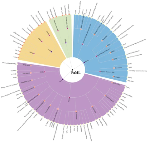
Physics-aware machine learning revolutionizes scientific paradigm for process-based modeling in hydrology
Accurate hydrological understanding and water cycle prediction are crucial for addressing scientific and societal challenges associated with the management of water resources. Existing reviews predominantly concentrate on the development of machine learning (ML) in this field, yet there is a clear distinction between hydrology and ML as separate paradigms.
Here, we introduce physics-aware ML as a transformative approach to overcome the perceived barrier and revolutionize both fields. Specifically, we present a comprehensive review of the physics-aware ML methods, building a structured community (PaML) of existing methodologies that integrate prior physical knowledge or physics-based modeling into ML. We systematically analyze these PaML methodologies with respect to four aspects: physical data-guided ML, physics-informed ML, physics-embedded ML, and physics-aware hybrid learning. These four approaches integrate ML with physics in diverse manners, offering models that balance interpretability, generalization, computational cost, representation, and operability. PaML facilitates ML-aided hypotheses, accelerating insights from big data and fostering scientific discoveries. We initiate a systematic exploration of hydrology in PaML, including rainfall-runoff and hydrodynamic processes. Our study highlights the most promising and challenging directions for different objectives in process-based hydrology, such as advancing PaML-based solutions and enhancing parameterization, calibration, data generation, spatio-temporal representation, and uncertainty quantification through PaML methods.
Finally, a new PaML-based hydrology community, termed HydroPML, is released as a foundation for hydrological applications. HydroPML enhances the explainability and causality of ML and lays the groundwork for the digital water cycle's realization. The HydroPML community is publicly accessible at https://hydropml.github.io/, with its resource hub available at https://github.com/HydroPML.
Reference: Qingsong Xu, Yilei Shi, Jonathan Bamber, Ye Tuo, Ralf Ludwig, Xiao Xiang Zhu (2025). Physics-aware machine learning revolutionizes scientific paradigm for process-based modeling in hydrology. Earth-Science Reviews, in press.
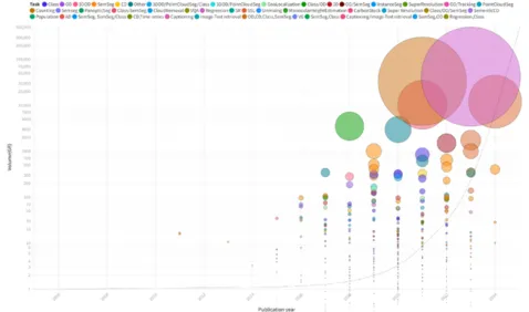
EarthNets: Empowering AI in Earth Observation
Earth observation (EO), aiming at monitoring the state of planet Earth using remote sensing data, is critical for improving our daily lives and living environment. With a growing number of satellites in orbit, an increasing number of datasets with diverse sensors and research domains are being published to facilitate the research of the remote sensing community. This paper presents a comprehensive review of more than 500 publicly published datasets, including research domains like agriculture, land use and land cover, disaster monitoring, scene understanding, vision-language models, foundation models, climate change, and weather forecasting. We systematically analyze these EO datasets from four aspects: volume, resolution distributions, research domains, and the correlation between datasets. Based on the dataset attributes, we propose to measure, rank, and select datasets to build a new benchmark for model evaluation. Furthermore, a new platform for EO, termed EarthNets, is released to achieve a fair and consistent evaluation of deep learning methods on remote sensing data. EarthNets supports standard dataset libraries and cutting-edge deep learning models to bridge the gap between the remote sensing and machine learning communities. Based on this platform, extensive deep-learning methods are evaluated on the new benchmark. The insightful results are beneficial to future research. The platform and dataset collections are publicly available at https://earthnets.github.io/.
Reference: Zhitong Xiong, Fahong Zhang, Yi Wang, Yilei Shi, Xiao Xiang Zhu (2024). EarthNets: Empowering AI in Earth Observation. IEEE Geoscience and Remote Sensing Magazine, in press. (link)
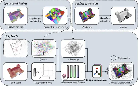
PolyGNN: Polyhedron-based Graph Neural Network for 3D Building Reconstruction from Point Clouds
We present PolyGNN, a polyhedron-based graph neural network for 3D building reconstruction from point clouds. PolyGNN learns to assemble primitives obtained by polyhedral decomposition via graph node classification, achieving a watertight and compact reconstruction. To effectively represent arbitrary-shaped polyhedra in the neural network, we propose a skeleton-based sampling strategy to generate polyhedron-wise queries. These queries are then incorporated with inter-polyhedron adjacency to enhance the classification. PolyGNN is end-to-end optimizable and is designed to accommodate variable-size input points, polyhedra, and queries with an index-driven batching technique. To address the abstraction gap between existing city-building models and the underlying instances, and provide a fair evaluation of the proposed method, we develop our method on a large-scale synthetic dataset with well-defined ground truths of polyhedral labels. We further conduct a transferability analysis across cities and on real-world point clouds. Both qualitative and quantitative results demonstrate the effectiveness of our method, particularly its efficiency for large-scale reconstructions. The source code and data are available at https://github.com/chenzhaiyu/polygnn.
Reference: Zhaiyu Chen, Yilei Shi, Liangliang Nan, Zhitong Xiong, Xiao Xiang Zhu (2024). PolyGNN: Polyhedron-based Graph Neural Network for 3D Building Reconstruction from Point Clouds. ISPRS Journal of Photogrammetry and Remote Sensing, 218 (2024): 693-706 (link).
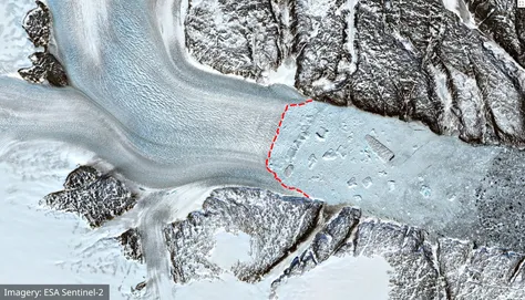
A High-Resolution Calving Front Data Product for Marine-Terminating Glaciers in Svalbard
Glacier calving fronts are an important indicator of the processes in the Earth's large ice sheets in Greenland and Antarctica. Existing approaches for calving front detection generally work by first performing a pixel-wise segmentation or edge detection, and then extract the actual calving front in a post-processing step. Our goal in this study is to build a model that only needs a single step, and directly outputs the calving front as a polyline. Following the idea of explicit contour prediction, we have developed a new method called “Charting Outlines by Recurrent Adaptation” (COBRA). It works by combining the idea of Active Contour models with deep learning. First, a 2D CNN backbone derives feature maps from the input imagery. Then, a 1D CNN (Snake Head) iteratively deforms an initial contour until to match the true contour. Evaluations on several large-scale datasets of Greenland's glaciers show that this approach is indeed better at predicting glacier calving fronts than previous methods.
The model results can be seen here: https://khdlr.github.io/COBRA/map.html
Reference: Tian Li, Konrad Heidler, Lichao Mou, Ádám Ignéczi, Xiao Xiang Zhu, Jonathan L Bamber (2024). A High-Resolution Calving Front Data Product for Marine-Terminating Glaciers in Svalbard. Earth System Science Data, 16, pp. 919–939. (link)
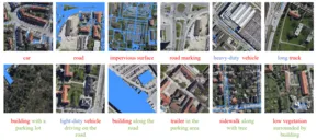
RRSIS: Referring Remote Sensing Image Segmentation
Localizing desired objects from remote sensing images is of great use in practical applications. Referring image segmentation, which aims at segmenting out the objects to which a given expression refers, has been extensively studied in natural images. However, almost no research attention is given to this task of remote sensing imagery. Considering its potential for real-world applications, in this paper, we introduce referring remote sensing image segmentation (RRSIS) to fill in this gap and make some insightful explorations. Specifically, we create a new dataset, called RefSegRS, for this task, enabling us to evaluate different methods. Afterward, we benchmark referring image segmentation methods of natural images on the RefSegRS dataset and find that these models show limited efficacy in detecting small and scattered objects. To alleviate this issue, we propose a language-guided cross-scale enhancement (LGCE) module that utilizes linguistic features to adaptively enhance multi-scale visual features by integrating both deep and shallow features. The proposed dataset, benchmarking results, and the designed LGCE module provide insights into the design of a better RRSIS model.
Reference: Zhenghang Yuan, Lichao Mou, Yuansheng Hua, Xiao Xiang Zhu (2024). RRSIS: Referring remote sensing image segmentation. IEEE Transactions Geoscience and Remote Sensing, 62, pp. 1-12. (link)
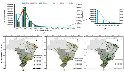
Assessing the Macro-scale Patterns of Urban Tree Canopy Cover in Brazil Using High-resolution Remote Sensing Images
Urban trees typically provide many environmental, social, and economic urban ecosystem services to people living in urban areas. Along streets, they mitigate air and noise pollution and urban forests provide a habitat for wildlife, such as insects, birds, and serrated animals, while also providing a cool living environment by mitigating urban heat. Therefore, studying patterns of UTC cover is important to promote environmental justice and support urban sustainable development in Brazil. To better understand the UTC cover patterns in Brazil, this study creates UTC products for 472 cities in Brazil based on high-resolution satellite images and an advanced CNN segmentation model and then conducts a comprehensive assessment of macro-scale patterns of UTC cover in Brazil by taking tree canopy coverage, human exposure, and determines into account. The results revealed that the UTC cover of Brazilian cities is spatially heterogeneous, ranging from 5% to 34%. There was a difference in UTC coverage between the old and new urban areas, with the average largest difference near 5%. More than 76% urban population exposure to UTC coverage of 0~0.2. Most cities have a relatively high inequality in human exposure to urban tree-covered spaces, especially in northeastern and southeastern Brazil. Results from the geographical detector models show climatic factors play a major role in determining the UTC cover patterns in Brazilian cities, followed by socioeconomic, geographical, soil, and urbanization factors. This study suggests the Brazilian government pay more attention to greening renovation projects in old urban areas and formulate effective urban tree irrigation policies for cities with limited autumn and winter rainfall. The study also suggests follow-up research on UTC cover patterns that consider the effects of race, urban history, city structure, land use, and local government policy factors to further support the goals of sustainable development in Brazilian cities.
Reference: Jianhua Guo, Zhiheng Liu, Xiao Xiang Zhu (2023). Assessing the Macro-scale Patterns of Urban Tree Canopy Cover in Brazil Using High-resolution Remote Sensing Images. Sustainable Cities and Society, 100, 105003.(link)
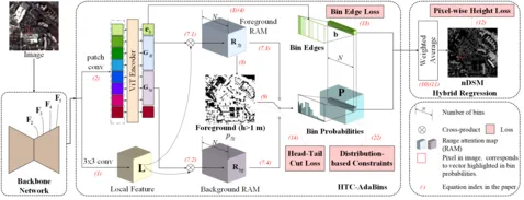
HTC-DC Net: Monocular Height Estimation from Single Remote Sensing Images
Three-dimensional geoinformation is of great significance for understanding the living environment; however, 3-D perception from remote sensing data, especially on a large scale, is restricted, mainly due to the high costs of 3-D sensors such as light detection and ranging (LiDAR). To tackle this problem, we propose a method for monocular height estimation from optical imagery, which is currently one of the richest sources of remote sensing data. As an ill-posed problem, monocular height estimation requires well-designed networks for enhanced representations to improve the performance. Moreover, the distribution of height values is long-tailed with the low-height pixels, e.g., the background (BG), as the head, and thus, trained networks are usually biased and tend to underestimate building heights. To solve the problems, instead of formalizing the problem as a regression task, we propose HTC-DC Net following the classification–regression paradigm, with the head-tail cut (HTC) and the distribution-based constraints (DCs) as the main contributions. HTC-DC Net is composed of the backbone network as the feature extractor, the HTC-AdaBins module, and the hybrid regression process. The HTC-AdaBins module serves as the classification phase to determine bins adaptive to each input image. It is equipped with a vision transformer (ViT) encoder to incorporate local context with holistic information and involves an HTC to address the long-tailed problem in monocular height estimation for balancing the performances of foreground (FG) and BG pixels. The hybrid regression process does the regression via the smoothing of bins from the classification phase, which is trained via DCs. The proposed network is tested on three datasets of different resolutions, namely ISPRS Vaihingen (0.09 m), Data Fusion Contest 19 (DFC19) (1.3 m), and Global Building Height (GBH) (3 m). The experimental results show the superiority of the proposed network over existing methods by large margins. Extensive ablation studies demonstrate the effectiveness of each design component
Reference: Sining Chen, Yilei Shi, Zhitong Xiong, Xiao Xiang Zhu (2023). HTC-DC Net: Monocular Height Estimation from Single Remote Sensing Images. IEEE Transactions Geoscience and Remote Sensing, 61 (2023): 1-18. (link)
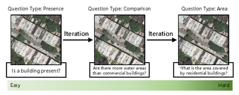
From Easy to Hard: Learning Language-guided Curriculum for Visual Question Answering on Remote Sensing Data.
Visual question answering (VQA) for remote sensing scene has great potential in intelligent human-computer interaction system. Although VQA in computer vision has been widely researched, VQA for remote sensing data (RSVQA) is still in its infancy. There are two characteristics that need to be specially considered for the RSVQA task. 1) No object annotations are available in RSVQA datasets, which makes it difficult for models to exploit informative region representation; 2) There are questions with clearly different difficulty levels for each image in the RSVQA task. Directly training a model with questions in a random order may confuse the model and limit the performance. To address these two problems, in this paper, a multi-level visual feature learning method is proposed to jointly extract language-guided holistic and regional image features. Besides, a self-paced curriculum learning (SPCL)-based VQA model is developed to train networks with samples in an easy-to-hard way. To be more specific, a language-guided SPCL method with a soft weighting strategy is explored in this work. The proposed model is evaluated on three public datasets, and extensive experimental results show that the proposed RSVQA framework can achieve promising performance.
Reference: Zhenghang Yuan, Lichao Mou, Qi Wang, Xiao Xiang Zhu (2022). From Easy to Hard: Learning Language-guided Curriculum for Visual Question Answering on Remote Sensing Data. IEEE Transactions on Geoscience and Remote Sensing, 60 (2022): 1-11. (link)
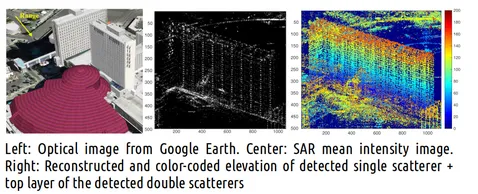
γ-Net: Superresolving SAR Tomographic Inversion via Deep Learning
Synthetic aperture radar tomography (TomoSAR) has been extensively employed in 3-D reconstruction in dense urban areas using high-resolution SAR acquisitions. Compressive sensing (CS)-based algorithms are generally considered as the state-of-the art in super-resolving TomoSAR, in particular in the single look case. This superior performance comes at the cost of extra computational burdens, because of the sparse reconstruction, which cannot be solved analytically, and we need to employ computationally expensive iterative solvers. In this article, we propose a novel deep learning-based superresolving TomoSAR inversion approach, γ -Net, to tackle this challenge. γ -Net adopts advanced complex-valued learned iterative shrinkage thresholding algorithm (CV-LISTA) to mimic the iterative optimization step in sparse reconstruction. Simulations show the height estimate from a well-trained γ -Net approaches the Cramér-Rao lower bound (CRLB) while improving the computational efficiency by one to two orders of magnitude comparing to the first-order CS-based methods. It also shows no degradation in the super-resolution power comparing to the state-of-the-art second-order TomoSAR solvers, which are much more computationally expensive than the first-order methods. Specifically, γ -Net reaches more than 90% detection rate in moderate super-resolving cases at 25 measurements at 6 dB SNR. Moreover, simulation at limited baselines demonstrates that the proposed algorithm outperforms the second-order CS-based method by a fair margin. Test on real TanDEM-X data with just
six interferograms also shows high-quality 3-D reconstruction with high-density detected double scatterers.
Reference: Kun Qian, Yuanyuan Wang, Yilei Shi, Xiao Xiang Zhu (2022). γ-Net: Superresolving SAR Tomographic Inversion via Deep Learning. IEEE Transactions on Geoscience and Remote Sensing, 60, pp. 1–16. (link)
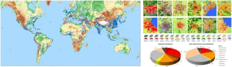
The urban morphology on our planet – Global perspectives from space
Urbanization is the second-largest megatrend, right after climate change. Accurate measurements of urban morphological and demographic figures are at the core of many international endeavours to address issues of urbanization, such as the United Nations’ call for “Sustainable Cities and Communities”. In many countries – particularly developing countries –, however, this database does not yet exist. Here, we demonstrate a novel deep learning and big data analytics approach to fuse freely available global radar and multi-spectral satellite data, acquired by the Sentinel-1 and Sentinel-2 satellites. Via this approach, we created the first-ever global and quality controlled urban local climate zones classification covering all cities across the globe with a population greater than 300,000 and made it available to the community. Statistical analysis of the data quantifies a global inequality problem: approximately 40% of the area defined as compact or light/large low-rise accommodates about 60% of the total population, whereas approximately 30% of the area defined as sparsely built accommodates only about 10% of the total population. Beyond, patterns of urban morphology were discovered from the global classification map, confirming a morphologic relationship to the geographical region and related cultural heritage. We expect the open access of our dataset to encourage research on the global change process of urbanization, as a multidisciplinary crowd of researchers will use this baseline for spatial perspective in their work. In addition, it can serve as a unique dataset for stakeholders such as the United Nations to improve their spatial assessments of urbanization.
Reference: Xiao Xiang Zhu, Chunping Qiu, Jingliang Hu, Yilei Shi, Yuanyuan Wang, Michael Schmitt, Hannes Taubenböck (2021). The Urban Morphology on Our Planet - Global Perspectives from Space. Remote Sensing of Environment, 269, p.112794. [code] [paper]
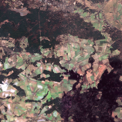
DENETHOR: The DynamicEarthNET dataset for Harmonized, inter-Operable, analysis-Ready, daily crop monitoring from space
Recent advances in remote sensing products allow near-real time monitoring of the Earth’s surface. Despite increasing availability of near-daily time-series of satellite imagery, there has been little exploration of deep learning methods to utilize the unprecedented temporal density of observations. This is particularly interesting in crop monitoring where time-series remote sensing data has been used frequently to exploit phenological differences of crops in the growing cycle over time. In this work, we present DENETHOR: The DynamicEarthNET dataset for Harmonized, inter-Operabel, analysis-Ready, daily crop monitoring from space. Our dataset contains daily, analysis-ready Planet Fusion data together with Sentinel-1 radar and Sentinel-2 optical time-series for crop type classification in Northern Germany. Our baseline experiments underline that incorporating the available spatial and temporal information fully may not be straightforward and could require the design of tailored architectures. The dataset presents two main challenges to the community: Exploit the temporal dimension for improved crop classification and ensure that models can handle a domain shift to a different year. Finally, the dataset is being used in the #AI4FoodSecurity challenge, organized by Planet, DLR, TUM and Radiant Earth, and hosted by ESA. Participate until December 19!
Reference: Lukas Kondmann, Aysim Toker, Marc Rußwurm, Andrés Camero, Devis Peressuti, Grega Milcinski, Pierre-Philippe Mathieu, Nicolas Longépé, Timothy Davis, Giovanni Marchisio, Laura Leal-Taixé, Xiao Xiang Zhu (2021). DENETHOR: The DynamicEarthNET dataset for Harmonized, inter-Operable, analysis-Ready, daily crop monitoring from space. In Thirty-fifth Conference on Neural Information Processing Systems (NeurIPS) Datasets and Benchmarks Track. [code][paper]
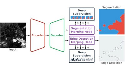
Mehr Informationen
HED-UNet: Combined Segmentation and Edge Detection for Monitoring the Antarctic Coastline.
Deep learning-based coastline detection algorithms have begun to outperform traditional statistical methods. However, these models are usually trained for as single-purpose: segment land and water, or delineate the coastline. On the other hand, a human annotator usually perform both tasks simultaneously. Considering this task duality, and inspired by the main building blocks of a semantic segmentation framework (UNet), and the edge detection framework (HED), we devised a new model that naturally combines both tasks: the HED-UNet. Training is made efficient by employing deep supervision on side predictions at multiple resolutions, and a hierarchical attention mechanism is introduced to adaptively merge these multiscale predictions into the final model output. The advantages of this approach are shown on a dataset of Sentinel-1 imagery covering parts of the Antarctic coast, where coastline detection is notoriously difficult.
Reference: Konrad Heidler, Lichao Mou, Celia Amélie Baumhoer, Andreas Dietz, Xiao Xiang Zhu (2021). HED-UNet: Combined Segmentation and Edge Detection for Monitoring the Antarctic Coastline. IEEE Transactions on Geoscience and Remote Sensing, doi: 10.1109/TGRS.2021.3064606. [code] [paper]
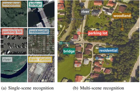
MultiScene: A Large-scale Dataset and Benchmark for Multi-scene Recognition in Single Aerial Images
Aerial scene recognition is a fundamental research problem in interpreting high-resolution aerial imagery. Over the past few years, most studies focus on classifying an image into one scene category, while in real-world scenarios, it is more often that a single image contains multiple scenes. Therefore, in this paper, we investigate a more practical yet underexplored task---multi-scene recognition in single images. To this end, we create a large-scale dataset, called MultiScene, composed of 100,000 unconstrained high-resolution aerial images. Considering that manually labeling such images is extremely arduous, we resort to low-cost annotations from crowdsourcing platforms, e.g., OpenStreetMap (OSM). However, OSM data might suffer from incompleteness and incorrectness, which introduce noise into image labels. To address this issue, we visually inspect 14,000 images and correct their scene labels, yielding a subset of cleanly-annotated images, named MultiScene-Clean. With it, we can develop and evaluate deep networks for multi-scene recognition using clean data. Moreover, we provide crowdsourced annotations of all images for the purpose of studying network learning with noisy labels. We conduct experiments with extensive baseline models on both MultiScene-Clean and MultiScene to offer benchmarks for multi-scene recognition in single images and learning from noisy labels for this task, respectively. To facilitate progress, we make our dataset and trained models available online.
Reference: Yuansheng Hua, Lichao Mou, Pu Jin, Xiao Xiang Zhu (2021). MultiScene: A Large-scale Dataset and Benchmark for Multi-scene Recognition in Single Aerial Images. IEEE Transactions on Geoscience and Remote Sensing, 60 (2021): 1-13. [code] [paper]
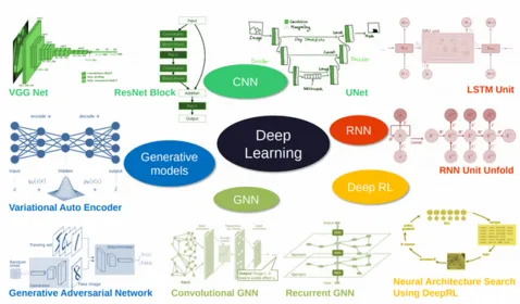
Deep Learning Meets SAR: Concepts, Models, Pitfalls, and Perspectives
Deep learning in remote sensing has become an international hype, but it is mostly limited to the evaluation of optical data. Although deep learning has been introduced in Synthetic Aperture Radar (SAR) data processing, despite successful first attempts, its huge potential remains locked. Here, we provide an introduction to the most relevant deep learning models and concepts, point out possible pitfalls by analyzing special characteristics of SAR data, review the state-of-the-art of deep learning applied to SAR in depth, summarize available benchmarks, and recommend some important future research directions. With this effort, we hope to stimulate more research in this interesting yet under-exploited research field and to pave the way for use of deep learning in big SAR data processing workflows.
Reference: Xiao Xiang Zhu, Sina Montazeri, Mohsin Ali, Yuansheng Hua, Yuanyuan Wang, Lichao Mou, Yilei Shi, Feng Xu, Richard Bamler (2021). Deep Learning Meets SAR: Concepts, Models, Pitfalls, and Perspectives. IEEE Geoscience and Remote Sensing Magazine, doi: 10.1109/MGRS.2020.3046356. [paper]