Project
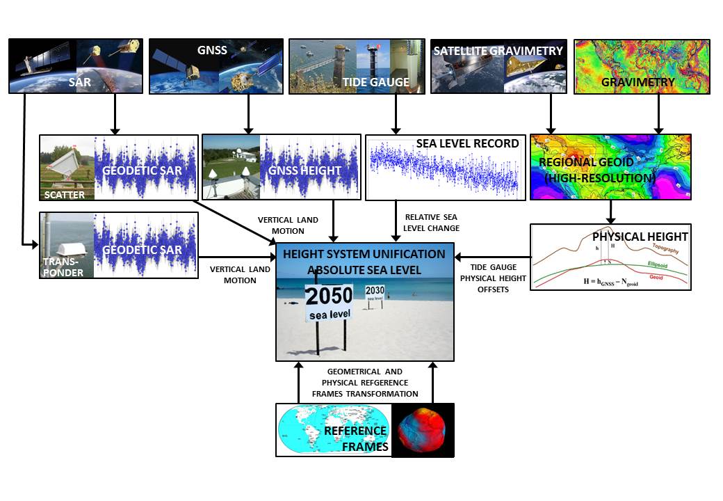
Height systems and related sea level observations are based on a number of measurement systems, which all have their own characteristics and deliver different type of observations. Traditionally, sea level is observed at tide gauge stations, which usually also serve as height reference stations for national levelling networks and therefore define a height system of a country. Thus sea level research across countries is closely linked to height system unification and needs to be regarded jointly. In order to analyse all observations they need to be available in a common reference frame. The following chart shows an overview about the observation techniques and their connection to the reference systems. The boxes at the top line represent the data needed to estimate the absolute sea level and its change at tide gauge locations. All other boxes represent tasks to be addressed by this project. These are ellipsoidal height determination from geodetic SAR and GNSS, physical height determination for tide gauge stations, determination of sea level heights as observed by tide gauges and estimation of transformation parameters between geometrical and physical reference frames. As a whole they deliver the required input to estimate the absolute sea level change and simultaneously the information needed to connect height systems across the sea.
Within this project three major objectives are addressed.
Objective 1: Geodetic SAR for connecting tide gauges to the GNSS network
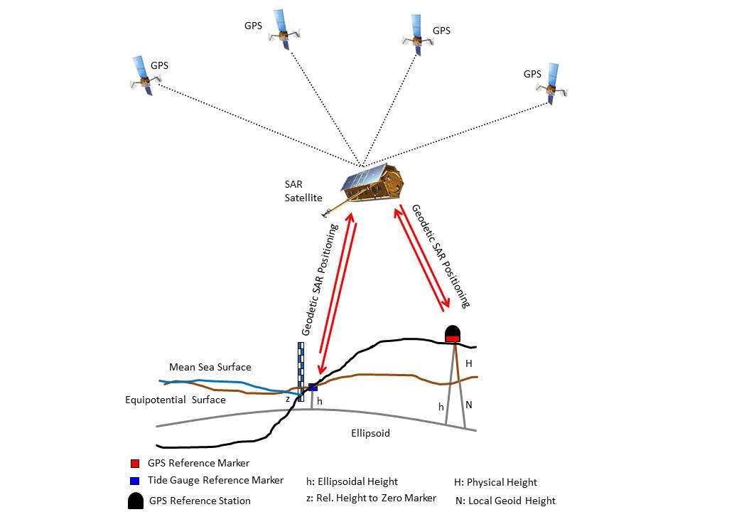
For the determination of ellipsoidal/geometric 3D-coordinates of points at the surface of the Earth the concept of geodetic SAR is a promising new technique. With this technique tide gauges not permanently equipped with a GNSS receiver can be connected to the geometric network of a country with relatively little effort on a permanent basis (see Figure). With availability of the Sentinel-1A/B SAR missions of the European Copernicus System, which are continuously providing SAR scenes worldwide with a short revisit time, the geodetic SAR technique can be applied on a systematic base for this purpose. It offers a relatively cheap and simple possibility to connect all tide gauges for an ocean area to the global geometric network, which is needed to disentangle the vertical land motion from the tide gauge readings.
Objective 2: GOCE based high resolution geoid at tide gauge stations
The available GOCE based satellite gravity field models and specifically the newest release of these models, provide a global physical height reference surface (geoid) with centimeter accuracy down to roughly 80 km resolution. Using these models as a global reference and combining them with local gravity information around the point of interest, the geoid can be determined with much higher resolution consistently worldwide, which is very useful to determine heights with the so-called GNSS-levelling approach (difference between the ellipsoidal height from GNSS and the geoid height from the GOCE based geoid). Knowing the geoid with sufficient accuracy and observing the geometric (ellipsoidal) heights by GNSS or by the geodetic SAR technique with adequate accuracy, physical heights can be easily determined at any point in the world without the need of doing repeated spirit levelling campaigns, which are costly and not always accurate enough. Therefore, the geodetic SAR technique offers the possibility to establish SAR-levelling as an efficient and accurate new tool with relatively low costs and instrument requirements. To connect height systems and to perform sea level analysis in an absolute sense consistent geoid heights are required at the tide gauges.
Objective 3: Compatibility of geometric and physical reference frames
As pointed out above, for height system unification and absolute sea level analysis a combination of geometric and physical heights needs to be done. Therefore, the applied geometric and physical reference systems need to be compatible in order to avoid systematic effects in the resulting height or sea level differences. Offsets between both reference systems and their relative change in time need to be identified and applied as corrections.