


- Demonstrating the potential for the reduction of temporal aliasing through tailored stochastic modelling of non-tidal atmosphere and ocean model uncertainties in closed-loop simulations. Journal of Geodesy 99 (7), 2025 mehr… BibTeX Volltext ( DOI )
- Effect of Coral Reefs on Wave Height Observed by Satellite Altimetry. Remote Sensing in Earth Systems Sciences, 2025 mehr… BibTeX Volltext ( DOI )
- Title: Impact of tone errors in future satellite gravimetry missions. Advances in Space Research, 2025 mehr… BibTeX Volltext ( DOI )
- Benefit of MAGIC and multi-pair quantum satellite gravity missions in Earth science applications. Geophysical Journal International, 2025 mehr… BibTeX Volltext ( DOI )
- Signal separation in geodetic observations: satellite gravimetry. Proceedings of the Royal Society A: Mathematical, Physical and Engineering Sciences 481 (2312), 2025 mehr… BibTeX Volltext ( DOI )
- Definition of Essential Geodetic Variables (EGV): Contribution of Geodesy to Earth Observation, White Paper. Global Geodetic Observing System (GGOS), 2025 mehr… BibTeX Volltext ( DOI )
- Benefit of classical leveling for geoid-based vertical reference frames. Journal of Geodesy 98 (7), 2024 mehr… BibTeX Volltext ( DOI )
- Properties of an optical event timer for satellite laser ranging. Journal of Geodesy 98 (8), 2024 mehr… BibTeX Volltext ( DOI )
- Satellite gravimetry: Methods, products, applications, and future trends. Earth-Science Reviews, 2024, 104783 mehr… BibTeX Volltext ( DOI )
- The Benefits of Future Quantum Accelerometers for Satellite Gravimetry. Earth and Space Science 11 (9), 2024 mehr… BibTeX Volltext ( DOI )
- Constellation design and performance of future quantum satellite gravity missions. Earth, Planets and Space 76 (1), 2024 mehr… BibTeX Volltext ( DOI )
- The Global Geodetic Observing System (GGOS) – Harnessing Geodesy for the Benefit of Science and Society. avn – allgemeine vermessungs-nachrichten (5), 2024, 256–269 mehr… BibTeX Volltext ( DOI )
- Relevance of PSInSAR Analyses at ITRF Co-location Sites. In: International Association of Geodesy Symposia. Springer Berlin Heidelberg, 2024 mehr… BibTeX Volltext ( DOI )
- Flatness constraints in the estimation of GNSS satellite antenna phase center offsets and variations. Journal of Geodesy 98, 2024 mehr… BibTeX Volltext ( DOI )
- A method to assess the quality of GNSS satellite phase bias products. GPS Solutions 28, 2024 mehr… BibTeX Volltext ( DOI )
- Improving Performance of Uncombined PPP-AR Model with Ambiguity Constraints. Remote Sensing 16, 2024 mehr… BibTeX Volltext ( DOI )
- Combination strategy for consistent final, rapid and predicted Earth rotation parameters. Journal of Geodesy 97 (1), 2023 mehr… BibTeX Volltext ( DOI )
- Impacts of frequency-dependent instrument noise for next-generation gravimetric mission on determining temporal gravity field model. Journal of Geodesy 97 (3), 2023 mehr… BibTeX Volltext ( DOI )
- Meteoroid ablation simulations with ESA’s SCARAB software. Planetary and Space Science 238, 2023, 105785 mehr… BibTeX Volltext ( DOI )
- Variations in the Earth’s rotation rate measured with a ring laser interferometer. Nature Photonics, 2023 mehr… BibTeX Volltext ( DOI )
- The impacts of reducing atmospheric and oceanic de-aliasing model error on temporal gravity field model determination. Geophysical Journal International 234 (1), 2023, 210-227 mehr… BibTeX Volltext ( DOI )
- Small satellite formations and constellations for observing sub-daily mass changes in the Earth system. Geophysical Journal International 234 (3), 2023, 1550-1567 mehr… BibTeX Volltext ( DOI )
- Mission design aspects for the mass change and geoscience international constellation (MAGIC). Geophysical Journal International 235 (1), 2023, 718-735 mehr… BibTeX Volltext ( DOI )
- Combination of Geometric and Gravimetric Datasets for the Estimation of High-Resolution Mass Balances of the Greenland Ice Sheet. Geophysical Journal International, 2023 mehr… BibTeX Volltext ( DOI )
- Mass-change And Geosciences International Constellation (MAGIC) expected impact on science and applications. Geophysical Journal International 236 (3), 2023, 1288-1308 mehr… BibTeX Volltext ( DOI )
- GENESIS: co-location of geodetic techniques in space. Earth, Planets and Space 75 (1), 2023 mehr… BibTeX Volltext ( DOI )
- Toward a Geodesy and Time Reference in Space (GETRIS): A Study of Apparent Satellite Clocks of a Future GNSS Satellite Constellation. Geosciences 13 (6), 2023, 173 mehr… BibTeX Volltext ( DOI )
- In-Orbit Performance of the GRACE Accelerometers and Microwave Ranging Instrument. Remote Sensing 15 (3), 2023, 563 mehr… BibTeX Volltext ( DOI )
- Colocation in Time and Space of High-Precision Two-Way Optical and Microwave Observations for Calibration of a Microwave Ranging Link—The ACES Mission Case. Remote Sensing 15 (20), 2023, 4897 mehr… BibTeX Volltext ( DOI )
- Space Gravity Missions: CHAMP, GRACE, GRACE-FO, and GOCE, Satellite Projects. In: Encyclopedia of Geodesy. Springer International Publishing, 2023 mehr… BibTeX Volltext ( DOI )
- Triple-frequency PPP-AR model comparison from the user perspective: combined and uncombined models. IEEE Symposium on Position Location and Navigation (PLANS), 2023 mehr… BibTeX Volltext ( DOI )
- Performance of Galileo satellite products determined from multi-frequency measurements. Journal of Geodesy 97 (4), 2023 mehr… BibTeX Volltext ( DOI )
- Assessment of a near-polar pair mission for detecting the Earth's temporal gravity field. Geophysical Journal International 234 (2), 2023, 852-869 mehr… BibTeX Volltext ( DOI )
- Bayerisches Satellitennetzwerk für Fernerkundung und Biomonitoring. zfv – Zeitschrift für Geodäsie, Geoinformation und Landmanagement (4/2023), 2023, 219-229 mehr… BibTeX Volltext ( DOI )
- Satellite range finding by photon counting against optical time ruler. Quantum Optics and Photon Counting 2023, SPIE, 2023 mehr… BibTeX Volltext ( DOI )
- Signal Separation in Global, Temporal Gravity Data. Proceedings of the 6th ACM SIGSPATIAL International Workshop on AI for Geographic Knowledge Discovery, ACM, 2023 mehr… BibTeX Volltext ( DOI )
- Proceedings of the 26th European VLBI Group for Geodesy and Astrometry Working Meeting. , 202326th EVGA Working Meeting, Bad Kötzting, Germany, 12-16 June, 2023 mehr… BibTeX Volltext ( DOI )
- Receiver Bias Estimation Strategy in the Uncombined Triple-Frequency PPP-AR Model. Proceedings of the 36th International Technical Meeting of the Satellite Division of The Institute of Navigation (ION GNSS+ 2023), Institute of Navigation, 2023 mehr… BibTeX Volltext ( DOI )
- Proceedings of the 26th European VLBI Group for Geodesy and Astrometry Working Meeting. , 26th EVGA Working Meeting, Bad Kötzting, Germany, 12-16 June, 2023. , 2023 mehr… BibTeX Volltext ( DOI ) Volltext (mediaTUM)
- Geodesy. De Gruyter (5th, completely revised edition. Aufl.), 2023 mehr… BibTeX Volltext ( DOI )
- Der aktuelle Stand der GNSS – ein Update. DVW Schriftenreihe, Wißner-Verlag, 2023 mehr… BibTeX
- Gestalt und Größe der Erde aus dem All. Physik in unserer Zeit 53 (1), 2022, 44-45 mehr… BibTeX Volltext ( DOI )
- Efficient variance component estimation for large-scale least-squares problems in satellite geodesy. Journal of Geodesy 96 (2), 2022 mehr… BibTeX Volltext ( DOI )
- Characterization and stabilization of the downward continuation problem for airborne gravity data. Journal of Geodesy 96 (4), 2022 mehr… BibTeX Volltext ( DOI )
- Potential of UT1–UTC transfer to the Galileo constellation using onboard VLBI transmitters. Journal of Geodesy 96 (10), 2022 mehr… BibTeX Volltext ( DOI )
- A new parallel algorithm for improving the computational efficiency of multi-GNSS precise orbit determination. GPS Solutions 26 (3), 2022 mehr… BibTeX Volltext ( DOI )
- Revisiting Force Model Error Modeling in GRACE Gravity Field Recovery. Surveys in Geophysics, 2022 mehr… BibTeX Volltext ( DOI )
- Geosynchronous satellites expanding a future GNSS satellite constellation: A precise orbit determination study. Advances in Space Research, 2022 mehr… BibTeX Volltext ( DOI )
- The GOP Analysis Center: DORIS contribution to ITRF2020. Advances in Space Research, 2022 mehr… BibTeX Volltext ( DOI )
- Ground-based laser momentum transfer concept for debris collision avoidance. Journal of Space Safety Engineering 9 (4), 2022, 612-624 mehr… BibTeX Volltext ( DOI )
- A proposed network of gamma-ray burst detectors on the global navigation satellite system <i>Galileo</i> G2. Astronomy & Astrophysics 664, 2022, A131 mehr… BibTeX Volltext ( DOI )
- Data-driven multi-step self-de-aliasing approach for GRACE and GRACE-FO data processing. Geophysical Journal International 232 (2), 2022, 1006-1030 mehr… BibTeX Volltext ( DOI )
- Precise orbit determination for a large LEO constellation with inter-satellite links and the measurements from different ground networks: a simulation study. Satellite Navigation 3 (22), 2022 mehr… BibTeX Volltext ( DOI )
- Geodetic SAR for Height System Unification and Sea Level Research—Results in the Baltic Sea Test Network. Remote Sensing 14 (14), 2022, 3250 mehr… BibTeX Volltext ( DOI )
- Hybrid Electrostatic–Atomic Accelerometer for Future Space Gravity Missions. Remote Sensing 14 (14), 2022, 3273 mehr… BibTeX Volltext ( DOI )
- Hybrid electrostatic-atomic accelerometer for future space gravity missions. , 2022 mehr… BibTeX Volltext ( DOI )
- Dilution of Precision (DOP) Factors for Evaluating Observations to Galileo Satellites with VLBI. In: International Association of Geodesy Symposia. Springer Berlin Heidelberg, 2022 mehr… BibTeX Volltext ( DOI )
- Estimating surface optical properties and thermal thrust for Galileo satellite body and solar panels. GPS Solutions 26 (4), 2022 mehr… BibTeX Volltext ( DOI )
- Copernicus Sentinel–1 POD Reprocessing Campaign. Advances in Space Research, 2022 mehr… BibTeX Volltext ( DOI )
- Closed loop simulations on recoverability of climate trends in next generation gravity missions. Geophysical Journal International 232 (2), 2022, 1083-1098 mehr… BibTeX Volltext ( DOI )
- BeiDou Satellite Radiation Force Models for Precise Orbit Determination and Geodetic Applications. IEEE Transactions on Aerospace and Electronic Systems 58 (4), 2022, 2823-2836 mehr… BibTeX Volltext ( DOI )
- Adjustment of Galileo satellite orbits with VLBI observations: a simulation study. Proceedings of the 12th IVS General Meeting, 2022 mehr… BibTeX
- Monitoring Gravitational Deformations of the Wettzell 20 m Radio Telescope’s Main Reflector Using a Leica RTC360. Proceedings of the 5th Joint International Symposium on Deformation Monitoring - JISDM 2022, Editorial de la Universitat Politècnica de València, 2022 mehr… BibTeX Volltext ( DOI )
- Improvement of the GRAV-D Processing. , Hrsg.: National Oceanic and Atmospheric Administration - National Geodetic Survey, 2021, mehr… BibTeX
- Strategy for the realisation of the International Height Reference System (IHRS). Journal of Geodesy 95 (3), 2021 mehr… BibTeX Volltext ( DOI )
- Galileo precise orbit determination with optical two-way links (OTWL): a continuous wave laser ranging and time transfer concept. Journal of Geodesy 95 (7), 2021 mehr… BibTeX Volltext ( DOI )
- A partition-enhanced least-squares collocation approach (PE-LSC). Journal of Geodesy 95 (8), 2021 mehr… BibTeX Volltext ( DOI )
- Colorado geoid computation experiment: overview and summary. Journal of Geodesy 95 (12), 2021 mehr… BibTeX Volltext ( DOI )
- Enhanced solar radiation pressure model for GPS satellites considering various physical effects. GPS Solutions 25 (2), 2021 mehr… BibTeX Volltext ( DOI )
- Comparisons of CODE and CNES/CLS GPS satellite bias products and applications in Sentinel-3 satellite precise orbit determination. GPS Solutions 25 (4), 2021 mehr… BibTeX Volltext ( DOI )
- Satellite Gravimetry: A Review of Its Realization. Surveys in Geophysics 42 (5), 2021, 1029-1074 mehr… BibTeX Volltext ( DOI )
- Review of Recent GNSS Modelling Improvements Based on CODEs Repro3 Contribution. Advances in Space Research, 2021 mehr… BibTeX Volltext ( DOI )
- Geodetic datum realization using SLR‐GNSS co‐location onboard Galileo and GLONASS. Journal of Geophysical Research: Solid Earth, 2021 mehr… BibTeX Volltext ( DOI )
- ROMY: a multicomponent ring laser for geodesy and geophysics. Geophysical Journal International 225 (1), 2021, 684-698 mehr… BibTeX Volltext ( DOI )
- Treatment of ocean tide background model errors in the context of GRACE/GRACE-FO data processing. Geophysical Journal International 228 (3), 2021, 1850-1865 mehr… BibTeX Volltext ( DOI )
- A review of property rights in outer space from a land management perspective. Journal of Property, Planning and Environmental Law 13 (2), 2021, 107-121 mehr… BibTeX Volltext ( DOI )
- DecaWave Ultra-Wideband Warm-Up Error Correction. IEEE Transactions on Aerospace and Electronic Systems 57 (1), 2021, 751-760 mehr… BibTeX Volltext ( DOI )
- In-Depth Verification of Sentinel-1 and TerraSAR-X Geolocation Accuracy Using the Australian Corner Reflector Array. IEEE Transactions on Geoscience and Remote Sensing 59 (2), 2021, 1154-1181 mehr… BibTeX Volltext ( DOI )
- LARAMOTIONS: a conceptual study on laser networks for near-term collision avoidance for space debris in the low Earth orbit. Applied Optics 60 (31), 2021, H24 mehr… BibTeX Volltext ( DOI )
- GOCO06s – a satellite-only global gravity field model. Earth System Science Data 13 (1), 2021, 99-118 mehr… BibTeX Volltext ( DOI )
- Estimating ambiguity fixed satellite orbit, integer clock and daily bias products for GPS L1/L2, L1/L5 and Galileo E1/E5a, E1/E5b signals. Journal of Geodesy 95 (4), 2021 mehr… BibTeX Volltext ( DOI )
- Caribbean plate tilted and actively dragged eastwards by low-viscosity asthenospheric flow. Nature Communications 12 (1), 2021 mehr… BibTeX Volltext ( DOI )
- Long-lived afterslip of the 2013 <i>M</i>w 6.1 Minab earthquake detected by Persistent Scatterer Interferometry along the Irer fault (western Makran-Zagros transition zone, Iran). Geophysical Journal International 229 (1), 2021, 171-185 mehr… BibTeX Volltext ( DOI )
- Mission Erde. Springer Berlin Heidelberg, 2021 mehr… BibTeX Volltext ( DOI )
- Remote Sensing by Satellite Gravimetry. MDPI, 2021 mehr… BibTeX Volltext ( DOI )
- VLBI enhancement of the Bernese GNSS Software for multi-technique analysis at BKG. Proceedings of the 25th European VLBI Group for Geodesy and Astrometry Working Meeting, 2021 mehr… BibTeX
- Integration of airborne gravimetry data filtering into residual least-squares collocation: example from the 1 cm geoid experiment. Journal of Geodesy 94 (8), 2020 mehr… BibTeX Volltext ( DOI )
- The combined global gravity field model XGM2019e. Journal of Geodesy 94 (7), 2020 mehr… BibTeX Volltext ( DOI )
- A Spectrally Consistent Globally Defined Geodetic Mean Dynamic Ocean Topography. Journal of Geophysical Research: Oceans 125 (7), 2020 mehr… BibTeX Volltext ( DOI )
- Evaluating Processing Choices for the Geodetic Estimation of Earth Orientation Parameters With Numerical Models of Global Geophysical Fluids. Journal of Geophysical Research: Solid Earth 125 (9), 2020 mehr… BibTeX Volltext ( DOI )
- Reconstruction of the Instantaneous Earth Rotation Vector with Sub-Arcsecond Resolution Using a Large Scale Ring Laser Array. Physical Review Letters 125 (3), 2020 mehr… BibTeX Volltext ( DOI )
- Self-Calibration for the Time-of-Arrival Positioning. IEEE Access 8, 2020, 65726-65733 mehr… BibTeX Volltext ( DOI )
- Testing gravity with cold-atom clocks in space. The European Physical Journal D 74 (8), 2020 mehr… BibTeX Volltext ( DOI )
- Determination of the Regularization Parameter to Combine Heterogeneous Observations in Regional Gravity Field Modeling. Remote Sensing 12 (10), 2020, 1617 mehr… BibTeX Volltext ( DOI )
- Self-Calibration for the Time Difference of Arrival Positioning. Sensors 20 (7), 2020, 2079 mehr… BibTeX Volltext ( DOI )
- Improving solar radiation pressure modeling for GLONASS satellites. Journal of Geodesy 94 (8), 2020 mehr… BibTeX Volltext ( DOI )
- GPS and GLONASS observable-specific code bias estimation: comparison of solutions from the IGS and MGEX networks. Journal of Geodesy 94 (8), 2020 mehr… BibTeX Volltext ( DOI )
- Inclusion of GPS clock estimates for satellites Sentinel-3A/3B in DORIS geodetic solutions. Journal of Geodesy 94 (116), 2020 mehr… BibTeX Volltext ( DOI )
- Regional gravity field refinement for (quasi-) geoid determination based on spherical radial basis functions in Colorado. Journal of Geodesy 94 (10), 2020 mehr… BibTeX Volltext ( DOI )
- Determination of precise Galileo orbits using combined GNSS and SLR observations. GPS Solutions 25 (1), 2020 mehr… BibTeX Volltext ( DOI )
- Earth’s gravity from space. Rendiconti Lincei. Scienze Fisiche e Naturali 31 (S1), 2020, 3-13 mehr… BibTeX Volltext ( DOI )
- A semi-analytic accuracy benchmark for Stokes flow in 3-D spherical mantle convection codes. GEM - Int. J. Geomathematics 11 (1), 2020, 1 mehr… BibTeX Volltext ( DOI )
- Galileo POD using optical inter-satellite links: A simulation study. Advances in Space Research 66 (7), 2020, 1558-1570 mehr… BibTeX Volltext ( DOI )
- Analysis of collision avoidance via ground-based laser momentum transfer. Journal of Space Safety Engineering 7 (3), 2020, 312-317 mehr… BibTeX Volltext ( DOI )
- Temporal Variations of the Marine Geoid. Journal of Geophysical Research: Oceans 125 (11), 2020 mehr… BibTeX Volltext ( DOI )
- Error Corrections for Ultrawideband Ranging. IEEE Transactions on Instrumentation and Measurement 69 (11), 2020, 9037-9047 mehr… BibTeX Volltext ( DOI )
- Triple-Pair Constellation Configurations for Temporal Gravity Field Retrieval. Remote Sensing 12 (5), 2020 mehr… BibTeX Volltext ( DOI )
- Temporal Gravity Signals in Reprocessed GOCE Gravitational Gradients. Remote Sensing 12 (21), 2020, 3483 mehr… BibTeX Volltext ( DOI )
- Geodetic SAR for Height System Unification and Sea Level Research—Observation Concept and Preliminary Results in the Baltic Sea. Remote Sensing 12 (22), 2020, 3747 mehr… BibTeX Volltext ( DOI )
- Consistent quantification of the impact of key mission design parameters on the performance of next-generation gravity missions. Geophysical Journal International 221 (2), 2020, 1190-1210 mehr… BibTeX Volltext ( DOI )
- Quantifying rates of “rifting while drifting” in the southern Gulf of California: The role of the southern Baja California microplate and its eastern boundary zone. Lithosphere 12 (1), 2020, 122-132 mehr… BibTeX Volltext ( DOI )
- New methods for linking science objectives to remote sensing observations: a concept study using single and dual-pair satellite gravimetry architectures. Earth and Space Science 01 (02), 2020 mehr… BibTeX Volltext ( DOI )
- Satellite gravitational gradiometry: methodological foundation and geomathematical advances;Mathematische Geodäsie/Mathematical Geodesy. Springer Berlin Heidelberg, 2020 mehr… BibTeX Volltext ( DOI )
- HD-GNSS: Real-Time Absolute Navigation at Sub-Centimetre Level. 7th International Colloquium on Scientific and Fundamental Aspects of GNSS / Galileo, 2020 mehr… BibTeX
- Impact of Uncertainties of GOCE Gravity Model on Crustal Thickness Estimates. Geophysical Journal International, 2020 mehr… BibTeX Volltext ( DOI )
- Prediction versus real-time orbit determination for GNSS satellites. GPS Solutions 23 (39), 2019 mehr… BibTeX Volltext ( DOI )
- The adjusted optical properties for Galileo/BeiDou-2/QZS-1 satellites and initial results on BeiDou-3e and QZS-2 satellites. Advances in Space Research 63 (5), 2019, 1803--1812 mehr… BibTeX Volltext ( DOI )
- Decawave UWB Clock Drift Correction and Power Self-Calibration. Sensors 19 (13), 2019, 2942 mehr… BibTeX Volltext ( DOI )
- Unique 4-DOF Relative Pose Estimation with Six Distances for UWB/V-SLAM-Based Devices. Sensors 19 (20), 2019, 4366 mehr… BibTeX Volltext ( DOI )
- Improved Time of Arrival measurement model for non-convex optimization. NAVIGATION 66 (1), 2019, 117-128 mehr… BibTeX Volltext ( DOI )
- Mechanism of error propagation from the subdaily Universal Time model into the celestial pole offsets estimated by VLBI. Advances in Space Research 63 (1), 2019, 51-62 mehr… BibTeX Volltext ( DOI )
- 20. Internationale Geodätische Woche Obergurgl, 2019 – Die Bestimmung physikalischer Höhen mit Satelliten. In: 20. Internationale Geodätische Woche Obergurgl, 2019. Wichmann, 2019, 59-68 mehr… BibTeX
- Applicability of NGGM near-real time simulations in flood detection. Journal of Geodetic Science 9 (1), 2019, 111-126 mehr… BibTeX Volltext ( DOI )
- Cap integration in spectral gravity forward modelling: near- and far-zone gravity effects via Molodensky's truncation coefficients. Journal of Geodesy 93 (1), 2019, 65--83 mehr… BibTeX Volltext ( DOI )
- Seismic Evidence for Plume‐Slab Interaction by High‐Resolution Imaging of the 410‐km Discontinuity Under Tonga. Geophysical Research Letters 46 (23), 2019, 13687-13694 mehr… BibTeX Volltext ( DOI )
- Southward propagation of Nazca subduction along the Andes. Nature 565 (7740), 2019, 441-447 mehr… BibTeX Volltext ( DOI )
- GNSS Orbit Prediction with Enhanced Solar Radiation Pressure Model. China Satellite Navigation Conference, 2019 mehr… BibTeX Volltext ( DOI )
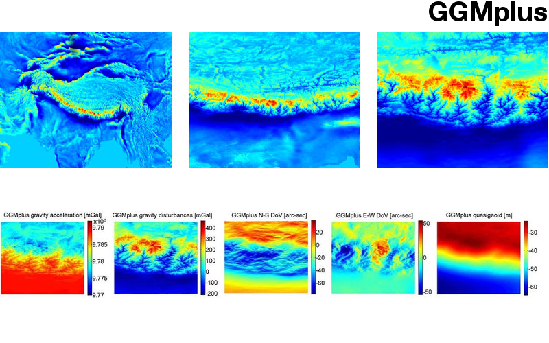
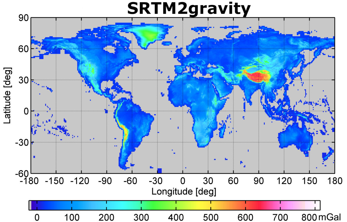
- SRTM2gravity: An Ultrahigh Resolution Global Model of Gravimetric Terrain Corrections. Geophysical Research Letters 46 (9), 2019 mehr… BibTeX Volltext ( DOI ) Volltext (mediaTUM)
- SPOOK - A comprehensive Space Surveillance and Tracking analysis tool. Acta Astronautica 158, 2019, 178-184 mehr… BibTeX Volltext ( DOI )
- Impact of a novel hybrid accelerometer on satellite gravimetry performance. Advances in Space Research 63 (10), 2019, 3235 - 3248 mehr… BibTeX Volltext ( DOI )
- Regional gravity field recovery of the void areas using SGG-derived surface residual gravity disturbances based on least-squares collocation: a case study in Iran. Journal of Applied Geophysics 164, 2019, 40 - 52 mehr… BibTeX Volltext ( DOI )
- Next generation gravity missions: near-real time gravity field retrieval strategy. Geophysical Journal International 217 (2), 2019, 1314-1333 mehr… BibTeX Volltext ( DOI )
- A Global Height System – Following Heinrich Bruns (1878). zfv – Zeitschrift für Geodäsie, Geoinformation und Landmanagement (1/2019), 2019, 17–24 mehr… BibTeX Volltext ( DOI )
- On the assimilation of absolute geodetic dynamic topography in a global ocean model: impact on the deep ocean state. Journal of Geodesy 93 (2), 2019, 141--157 mehr… BibTeX Volltext ( DOI )
- Influence of subdaily model for polar motion on the estimated GPS satellite orbits. Journal of Geodesy 93 (2), 2019, 229--240 mehr… BibTeX Volltext ( DOI )
- Divergence-free spherical harmonic gravity field modelling based on the Runge--Krarup theorem: a case study for the Moon. Journal of Geodesy 93 (4), 2019, 489--513 mehr… BibTeX Volltext ( DOI )
- A numerical study of residual terrain modelling (RTM) techniques and the harmonic correction using ultra-high-degree spectral gravity modelling. Journal of Geodesy 93 (9), 2019, 1469--1486 mehr… BibTeX Volltext ( DOI )
- GOCE gradiometer data calibration. Journal of Geodesy 93 (9), 2019, 1603--1630 mehr… BibTeX Volltext ( DOI )
- Cap integration in spectral gravity forward modelling up to the full gravity tensor. Journal of Geodesy 93 (9), 2019, 1707--1737 mehr… BibTeX Volltext ( DOI )
- Residual least-squares collocation: use of covariance matrices from high-resolution global geopotential models. Journal of Geodesy 93 (9), 2019, 1739--1757 mehr… BibTeX Volltext ( DOI )
- Residual terrain modelling (RTM) in terms of the cap-modified spectral technique: RTM from a new perspective. Journal of Geodesy 93 (10), 2019, 2089--2108 mehr… BibTeX Volltext ( DOI )
- Evaluation of terrestrial and airborne gravity data over Antarctica – a generic approach. Journal of Geodetic Science 9 (1), 2019, 29--30 mehr… BibTeX Volltext ( DOI )
- Evaluating GRACE Mass Change Time Series for the Antarctic and Greenland Ice Sheet—Methods and Results. Geosciences 9 (10), 2019 mehr… BibTeX Volltext ( DOI )
- Gravity Field Recovery Using High-Precision, High–Low Inter-Satellite Links. Remote Sensing 11 (5), 2019 mehr… BibTeX Volltext ( DOI )
- Mass variation observing system by high low inter-satellite links (MOBILE) – a new concept for sustained observation of mass transport from space. Journal of Geodetic Science 9 (1), 2019, 48--58 mehr… BibTeX Volltext ( DOI )
- Signal and error assessment of GOCE-based high resolution gravity field models. Journal of Geodetic Science 9 (1), 2019, 71--86 mehr… BibTeX Volltext ( DOI )
- Mass balance of the Greenland Ice Sheet from 1992 to 2018. Nature, 2019, 1--1 mehr… BibTeX Volltext ( DOI )
- Next-Generation Gravity Missions: Sino-European Numerical Simulation Comparison Exercise. Remote Sensing 11 (22), 2019, 2654 mehr… BibTeX Volltext ( DOI )
- GOCE Variance and Covariance Contribution to Height System Unification. International Symposium on Gravity, Geoid and Height Systems 2016, Springer International Publishing, 2019 mehr… BibTeX
- Gravimetric Investigations at Vernagtferner. International Symposium on Gravity, Geoid and Height Systems 2016, Springer International Publishing, 2019 mehr… BibTeX
- Analysis of GOCE Omission Error and Its Contribution to Vertical Datum Offsets in Greece and Its Islands. International Symposium on Gravity, Geoid and Height Systems 2016, Springer International Publishing, 2019 mehr… BibTeX
- Time and laser ranging: a window of opportunity for geodesy, navigation, and metrology. Journal of Geodesy 93 (11), 2018, 2389-2404 mehr… BibTeX Volltext ( DOI )
- On the observability of epeirogenic movement in current and future gravity missions. Gondwana Research 53 (Supplement C), 2018, 273 - 284 mehr… BibTeX Volltext ( DOI )
- Solution to the spectral filter problem of residual terrain modelling (RTM). Journal of Geodesy 92 (6), 2018, 675--690 mehr… BibTeX Volltext ( DOI )
- Assessment of Dynamic Geo-Positioning Using Multi-constellation GNSS in Challenging Environments. In: Data Analytics: Paving the Way to Sustainable Urban Mobility. Springer International Publishing, 2018 mehr… BibTeX Volltext ( DOI )
- Design of Mega-Constellations of LEO Satellites for Positioning. In: Lecture Notes in Electrical Engineering. Springer Singapore, 2018 mehr… BibTeX Volltext ( DOI )
- Analysis on the Representation of Polar Motion in GNSS Applications. In: Lecture Notes in Electrical Engineering. Springer Singapore, 2018 mehr… BibTeX Volltext ( DOI )
- Mass balance of the {Antarctic} {Ice} {Sheet} from 1992 to 2017. Nature 558 (7709), 2018, 219--222 mehr… BibTeX Volltext ( DOI )
- Orbit Prediction Uncertainty of Space Debris due to Drag Model Eerrors. Astrodynamics 2017, PTS I-IV, 2018 mehr… BibTeX
- Improved Time of Arrival Measurement Model for Non-Convex Optimization with Noisy Data. 2018 Ninth International Conference on Indoor Positioning and Indoor Navigation (IPIN), 2018 mehr… BibTeX
- Artefact detection in global digital elevation models (DEMs): The maximum slope approach and its application for complete screening of the SRTM v4.1 and MERIT DEMs. Remote Sensing of Environment 207, 2018, 27-41 mehr… BibTeX Volltext ( DOI ) Volltext (mediaTUM)
- Definition of Physical Height Systems for Telluric Planets and Moons. Surveys in Geophysics, 2018 mehr… BibTeX Volltext ( DOI )
- Reactivation of the Venezuelan vertical deflection data set from classical astrogeodetic observations. Journal of South American Earth Sciences 85, 2018, 97-107 mehr… BibTeX Volltext ( DOI ) Volltext (mediaTUM)
- Altimetry, gravimetry, GPS and viscoelastic modeling data for the joint inversion for glacial isostatic adjustment in Antarctica (ESA STSE Project REGINA). Earth System Science Data 10 (1), 2018, 493--523 mehr… BibTeX Volltext ( DOI )
- Short note: the experimental geopotential model XGM2016. Journal of Geodesy 92 (4), 2018, 443--451 mehr… BibTeX Volltext ( DOI )
- Insights from recent gravity satellite missions in the density structure of continental margins – With focus on the passive margins of the South Atlantic. Gondwana Research 53 (Supplement C), 2018, 285 - 308 mehr… BibTeX Volltext ( DOI )
- Decorrelation of GRACE Time Variable Gravity Field Solutions Using Full Covariance Information. Geosciences 8 (9), 2018 mehr… BibTeX Volltext ( DOI )
- Estimation of the Length of Day (LOD) from DORIS observations. Advances in Space Research 62 (2), 2018, 370-382 mehr… BibTeX Volltext ( DOI )
- Treatment of ocean tide aliasing in the context of a next generation gravity field mission. Geophysical Journal International 214 (1), 2018, 345-365 mehr… BibTeX Volltext ( DOI )
- All in fiber SESAM based comb oscillator with an intra-cavity electro-optic modulator for coherent high bandwidth stabilization. Optics Express 26 (18), 2018, 23798-23807 mehr… BibTeX Volltext ( DOI )
- Dynamic Vertical Mapping with Crowdsourced Smartphone Sensor Data. Sensors 18 (2), 2018, 480 mehr… BibTeX Volltext ( DOI )
- A high-precision digital astrogeodetic traverse in an area of steep geoid gradients close to the coast of Perth, Western Australia. Journal of Geodesy 92 (10), 2018, 1143--1153 mehr… BibTeX Volltext ( DOI )
- Estimation of satellite position, clock and phase bias corrections. Journal of Geodesy 92 (10), 2018, 1199--1217 mehr… BibTeX Volltext ( DOI )
- Correction to: Estimation of satellite position, clock and phase bias corrections. Journal of Geodesy 92 (10), 2018, 1219--1221 mehr… BibTeX Volltext ( DOI )
- Consistent estimation of geodetic parameters from SLR satellite constellation measurements. Journal of Geodesy 92 (9), 2018, 1003--1021 mehr… BibTeX Volltext ( DOI )
- Experiences with the use of mass-density maps in residual gravity forward modelling. Studia Geophysica et Geodaetica 62 (4), 2018, 596--623 mehr… BibTeX Volltext ( DOI )
- Auf den Spuren des wissenschaftlichen Wirkens von Friedrich Robert Helmert: Zum 175. Geburtstag. , 2018 mehr… BibTeX Volltext ( DOI )
- Ranging the GNSS Constellation. Proceedings of 20th International Workshop on Laser Ranging, 9.-14- October 2016, Potsdam, Germany, 2017 mehr… BibTeX
- Two-color and multistatic space debris tracking. Proceedings of 20th International Workshop on Laser Ranging, 9.-14. October 2016, Potsdam, Germany, 2017 mehr… BibTeX
- Satellite laser ranging in the near-infrared regime. SPIE Optics + Optoelectronics 10229, 2017, 102290J–102290J–7 mehr… BibTeX Volltext ( DOI )
- Current status of automation of the SLR-systems at the Geodetic Observatory Wettzell. Proceedings of the 20th international workshop on laser ranging, ILRS, 2017 mehr… BibTeX
- High-accuracy absolute rotation rate measurements with a large ring lyser gyro: establishing the scale factor. Appl. Opt 56 (4), 2017, 1124-1130 mehr… BibTeX Volltext ( DOI )
- Seafloor ground rotation observations: potential for improving signal-to-noise ratio on horizontal OBS components. Seismological Research Letters 88 (4), 2017, 1-19 mehr… BibTeX Volltext ( DOI )
- An Event Database for Rotational Seismology. Seismological Research Letters 88 (3), 2017, 935-941 mehr… BibTeX Volltext ( DOI )
- Comparing Direct Observation of Strain, Rotation and Displacement with Array Estimates at Pinon Flat Obeservatory, California. Seismological Research Letters 88 (4), 2017, 1107-1116 mehr… BibTeX Volltext ( DOI )
- Globale Satellitennavigationssysteme - Status und Ausblick. Schriftenreihe des DVW 2017 (87), 2017, 9-22 mehr… BibTeX
- Laser Ranging to GNSS Satellites. GPS World 28 (5), 2017, 42-48 mehr… BibTeX
- Gravity field recovery in the framework of a Geodesy and Time Reference in Space (GETRIS). Advances in Space Research 59 (2017) (8, 15 April 2017), 2017, 2032-2047 mehr… BibTeX Volltext ( DOI )
- Sentinel-1A – First precise orbit determination results. Advances in Space Research 60 (5), 2017, 879-892 mehr… BibTeX Volltext ( DOI )
- Comparison of glacier mass balance data in the Tien Shan and Pamir, Central Asia. Arctic, Antarctic, and Alpine Research 2017 (49, 1), 2017, 133–146 mehr… BibTeX Volltext ( DOI )
- Co-Location on the Ground and in Space. Proceedings of the First International Workshop on VLBI Observations of Near-field Targets, Schriftenreihe des Instituts für Geodäsie und Geoinformation, Instituts für Geodäsie und Geoinformation der Rheinischen Friedrich-Wilhelms-Universität Bonn, 2017 mehr… BibTeX
- Observing the Chang’E-3 Lander with VLBI (OCEL). Proceedings of the First International Workshop on VLBI Observations of Near-field Targets, Schriftenreihe des Instituts für Geodäsie und Geoinformation, Instituts für Geodäsie und Geoinformation der Rheinischen Friedrich-Wilhelms-Universität Bonn, 2017 mehr… BibTeX
- Satellite Orbits and Attitude – 3. In: Handbook of Global Navigation Satellite Systems. Springer, 2017, 59-90 mehr… BibTeX Volltext ( DOI )
- Differential geodetic stereo SAR with TerraSAR-X by exploiting small multi-directional radar reflectors. Journal of Geodesy 91 (1), 2017, 53-67 mehr… BibTeX Volltext ( DOI )
- Model improvements and validation of TerraSAR-X precise orbit determination. Journal of Geodesy 91 (5), 2017, 547-562 mehr… BibTeX Volltext ( DOI )
- GOCO05c: A New Combined Gravity Field Model Based on Full Normal Equations and Regionally Varying Weighting. Surveys in Geophysics 38 (3), 2017, 571–590 mehr… BibTeX Volltext ( DOI )
- Definition and Proposed Realization of the International Height Reference System (IHRS). Surveys in Geophysics 38 (3), 2017, 549-570 mehr… BibTeX Volltext ( DOI )
- Convergence and divergence in spherical harmonic series of the gravitational field generated by high‐resolution planetary topography – a case study for the Moon. Journal of Geophysical Research – Planets 2017 (122), 2017 mehr… BibTeX Volltext ( DOI ) Volltext (mediaTUM)
- Research and Analysis of Lunar Radio Measurements of the Chang’E-3 Lander. Proceedings of the First International Workshop on VLBI Observations of Near-field Targets, Schriftenreihe des Instituts für Geodäsie und Geoinformation, Instituts für Geodäsie und Geoinformation der Rheinischen Friedrich-Wilhelms-Universität Bonn, 2017 mehr… BibTeX
- A Novel Approach for Dynamic Vertical Indoor Mapping through Crowd-sourced Smartphone Sensor Data. Indoor Positioning and Indoor Navigation - IPIN 2017, September 18-21, 2017 mehr… BibTeX
- Camera pose refinement by matching uncertain 3D building models with thermal infrared image sequences for high quality texture extraction. ISPRS Journal of Photogrammetry and Remote Sensing 132 (2017), 2017, 33-47 mehr… BibTeX Volltext ( DOI )
- Joint inversion estimate of regional glacial isostatic adjustment in Antarctica considering a lateral varying Earth structure (ESA STSE Project REGINA). Geophysical Journal International, 2017 mehr… BibTeX Volltext ( DOI )
- Höhensysteme der nächsten Generation. In: Erdmessung und Satellitengeodäsie: Handbuch der Geodäsie, herausgegeben von Willi Freeden und Reiner Rummel. Springer Berlin Heidelberg, 2017, 349--400 mehr… BibTeX Volltext ( DOI )
- Globale Schwerefeldmodellierung am Beispiel von GOCE. In: Erdmessung und Satellitengeodäsie: Handbuch der Geodäsie, herausgegeben von Willi Freeden und Reiner Rummel. Springer Berlin Heidelberg, 2017, 217--257 mehr… BibTeX Volltext ( DOI )
- Influence of subdaily polar motion model on nutation offsets estimated by very long baseline interferometry. Journal of Geodesy 91 (12), 2017, 1503--1512 mehr… BibTeX Volltext ( DOI )
- Treatment of temporal aliasing effects in the context of next generation satellite gravimetry missions. Journal of Geophysical Research: Solid Earth 122 (9), 2017, 7343--7362 mehr… BibTeX Volltext ( DOI )
- Retrieving geophysical signals from current and future satellite gravity missions. Verlag der Bayerischen Akademie der Wissenschaften (München) , (DGK Reihe C 803), 2017, mehr… BibTeX
- Topographische Modellierung des Gravitationsfeldes. In: Erdmessung und Satellitengeodäsie: Handbuch der Geodäsie, herausgegeben von Willi Freeden und Reiner Rummel. Springer Berlin Heidelberg, 2017, 259--294 mehr… BibTeX Volltext ( DOI ) Volltext (mediaTUM)
- The relation between degree-2160 spectral models of Earth's gravitational and topographic potential: a guide on global correlation measures and their dependency on approximation effects. Journal of Geodesy 91 (10), 2017, 1179--1205 mehr… BibTeX Volltext ( DOI ) Volltext (mediaTUM)
- Über die Anziehungskraft der Erde. Jahrbuch 2016 der Braunschweigischen Wissenschaftlichen Gesellschaft 2016, 2017, 269--283 mehr… BibTeX Volltext ( DOI )
- Satellite Altimetry over Oceans and Land Surfaces. CRC Press, 2017 mehr… BibTeX Volltext ( DOI )
- Global Gravity Field Modeling from Satellite-to-Satellite Tracking Data. Springer International Publishing, 2017 mehr… BibTeX Volltext ( DOI )
- Retrieving geophysical signals from current and future satellite gravity missions. , 2017 mehr… BibTeX
- Spectral Solutions to the Topographic Potential in the context of High-Resolution Global Gravity Field Modelling. , 2017 mehr… BibTeX
- Estimating maneuvers for precise relative orbit determination using GPS. Adv.Space Res., 2016 mehr… BibTeX Volltext ( DOI )
- Geodetic Observatory Wettzell. Max-Planck-Institut für Radioastronomie, 2016, mehr… BibTeX
- RadioAstron gravitational redshift experiment: status update. 14th Marcel Grossmann Meeting Proceedings, Astrophysics - Instrumentation and Methods for Astrophysics, 2016 mehr… BibTeX
- Seafloor ground rotation observations: potential for improving signal-to-noise ratio on horizontal OBS components. Seismological Research Letters, 2016, 1-19 mehr… BibTeX Volltext ( DOI )
- Sub-ns time transfer consistency: a direct comparison between GPS CV and T2L2. Metrologia 53 (6), 2016, 1395-1401 mehr… BibTeX
- Current Status of an Implementation of a System Monitoring for Seamless Auxiliary Data at the Geodetic Observatory Wettzell. International VLBI Service for Geodesy and Astrometry 2016 General Meeting Proceedings - "New Horizons with VGOS", 2016, 101-105 mehr… BibTeX
- The German Antarctic Receiving Station O’Higgins and its VLBI Capabilities. International VLBI Service for Geodesy and Astrometry 2016 General Meeting Proceedings - "New Horizons with VGOS", 2016, 146-148 mehr… BibTeX
- First Local Ties from Data of the Wettzell Triple Radio Telescope Array. International VLBI Service for Geodesy and Astrometry 2016 General Meeting Proceedings - "New Horizons with VGOS", 2016, 149-153 mehr… BibTeX
- Venus and Mars Express Spacecraft Observations with Wettzell Radio Telescopes. International VLBI Service for Geodesy and Astrometry 2016 General Meeting Proceedings - "New Horizons with VGOS", 2016, 382-385 mehr… BibTeX
- Ultra-high-degree extension (v1.0) of SHTOOLS. 2016 mehr… BibTeX
- High-Accuracy Ring Laser Gyroscopes: Earth Rotation Rate and Relativistic Effects. J. Phys: Conference Series (723), 2016, 012061–7 mehr… BibTeX Volltext ( DOI )
- SAR ground control point identification with the aid of high resolution optical data. Geoscience and Remote Sensing Symposium (IGARSS), 2016 IEEE International, IEEE, 2016 mehr… BibTeX Volltext ( DOI )
- Geodetic stereo SAR with small multi-directional radar reflectors. Geoscience and Remote Sensing Symposium (IGARSS), 2016 IEEE International, IEEE, 2016 mehr… BibTeX Volltext ( DOI )
- Sub-ns time transfer consistency: a direct comparison between GPS CV and T2L2. Metrologia 2016 (53, 6), 2016, 1395–1401 mehr… BibTeX
- The VGOS TWIN Radio Telescope TTW2 at Wettzell. International VLBI Service for Geodesy and Astrometry 2016 General Meeting Proceedings - "New Horizons with VGOS", National Aeronautics and Space Administration, Goddard Space Flight Center, 2016 mehr… BibTeX
- First Results of the FAST-S/X Sessions with New VGOS Antennas. International VLBI Service for Geodesy and Astrometry 2016 General Meeting Proceedings - "New Horizons with VGOS", National Aeronautics and Space Administration, Goddard Space Flight Center, 2016 mehr… BibTeX
- Seasonal variations in the Rayleigh-to-Love wave ratio in the secondary microseism from colocated ring laser and seismograph. Journal of Geophysical Research: Solid Earth 121 (4), 2016, 2447–2459 mehr… BibTeX Volltext ( DOI )
- Planetary Radio Interferometry and Doppler Experiment (PRIDE) technique: a test case of the Mars Express Phobos fly-by. Astronomy & Astrophysics (A&A) (593, A34), 2016 mehr… BibTeX Volltext ( DOI )
- A Particle Filter for Orbit Determination of Space Debris based on Mono- and Multi-static Laser Ranging. Advances in the Astronautical Sciences, AAS/AIAA Space Flight Mechanics Meeting 2016, Univelt, 2016 mehr… BibTeX
- Höhensysteme der nächsten Generation – 7-1. In: Handbuch der Geodäsie. Springer, 2016 mehr… BibTeX Volltext ( DOI )
- Globale Schwerefeldmodellierung am Beispiel von GOCE – 8-1. In: Handbuch der Geodäsie. Springer, 2016 mehr… BibTeX Volltext ( DOI )
- High resolution gravity field modeling. High Performance Computing in Science and Engineering, Garching/Munich 2016, Bayerische Akademie der Wissenschaften, 2016 mehr… BibTeX
- Gravity field processing towards future LL-SST satellite missions. Verlag der Bayerischen Akademie der Wissenschaften, 2016, mehr… BibTeX
- Interaction between Subdaily Earth Rotation Parameters and GPS Orbits. International Association of Geodesy Symposia, Proceedings of the 2013 IAG Scientific Assembly, Springer, 2016 mehr… BibTeX Volltext ( DOI )
- GGOS Bureau of Products and Standards Inventory of Standards and Conventions for Geodesy. International Association of Geodesy Symposia, Proceedings of the 2013 IAG Scientific Assembly, Springer, 2016 mehr… BibTeX Volltext ( DOI )
- Monitoring Antenna Changes at IGS Stations in Iceland. International Association of Geodesy Symposia, Proceedings of the 2013 IAG Scientific Assembly, Springer, 2016 mehr… BibTeX Volltext ( DOI )
- Combination of Ground- and Space-Based GPS Data for the Determination of a Multi-scale Regional 4-D Ionosphere Model. International Association of Geodesy Symposia, Proceedings of the 2013 IAG Scientific Assembly, Springer, 2016 mehr… BibTeX Volltext ( DOI )
- Contribution of mass density heterogeneities to the quasigeoid-to-geoid separation. Journal of Geodesy 90 (1), 2016, 65-80 mehr… BibTeX Volltext ( DOI )
- Absolute IGS antenna phase center model igs08.atx: status and potential improvements. Journal of Geodesy 90 (4), 2016, 343-364 mehr… BibTeX Volltext ( DOI )
- Layer-based modelling of the Earth’s gravitational potential up to 10km-scale in spherical harmonics in spherical and ellipsoidal approximation. Surveys in Geophysics 37 (6), 2016, 1035 mehr… BibTeX Volltext ( DOI ) Volltext (mediaTUM)
- Topographic gravitational potential up to second-order derivatives: an examination of approximation errors caused by rock-equivalent topography (RET). Journal of Geodesy 90, 2016 mehr… BibTeX Volltext ( DOI ) Volltext (mediaTUM)
- Experiences with the QDaedalus system for astrogeodetic determination of deflections of the vertical. Survey Review 48, 2016 mehr… BibTeX Volltext ( DOI ) Volltext (mediaTUM)
- Topographic gravity modelling for global Bouguer maps to degree 2,160: Validation of spectral and spatial domain forward modelling techniques at the 10 microgal-level. Journal of Geophysical Research: Solid Earth 121 (9), 2016, 6846 mehr… BibTeX Volltext ( DOI ) Volltext (mediaTUM)
- A new degree-2190 (10 km resolution) gravity field model for Antarctica developed from GRACE, GOCE and Bedmap2 data. Journal of Geodesy 90 (2), 2016, 105-127 mehr… BibTeX Volltext ( DOI ) Volltext (mediaTUM)
- Gravity Forward Modelling – 2. In: Encyclopedia of Geodesy. Springer, Berlin, New York, 2016 mehr… BibTeX Volltext ( DOI ) Volltext (mediaTUM)
- Digital Terrain Models – 2. In: Encyclopedia of Geodesy. Springer, Berlin, New York, 2016 mehr… BibTeX Volltext ( DOI ) Volltext (mediaTUM)
- Topographische Modellierung des Gravitationsfeldes – 2. In: Handbuch der Geodäsie. Springer, Berlin, New York, 2016 mehr… BibTeX Volltext ( DOI ) Volltext (mediaTUM)
- Evaluation of intermediate TanDEM-X digital elevation data products over Tasmania using other digital elevation models and accurate heights from the Australian National Gravity Database. Australian Journal of Earth Sciences 63 (5), 2016, 599-609 mehr… BibTeX Volltext ( DOI ) Volltext (mediaTUM)
- Gravity field processing towards future LL-SST satellite missions. , 2016 mehr… BibTeX
- Analysis of Mono- and Multi-static Laser Ranging Scenarios for Orbit Improvement of Space Debris. Proceedings of the 25th International Symposium on Space Flight Dynamics, 2015 mehr… BibTeX
- Quality-based building-texture selection from different sensors. Proceedings of JURSE 2015, 2015 mehr… BibTeX
- International GNSS Service (IGS) Troposphere Products and Working Group Activities. Proceedings of the FIG Working Week 2015, 2015 mehr… BibTeX
- Estimate of Rayleight-to-Love wave ratio in the secondary microseism by colocated ring laser and seismograph. Geophysical Research Letters, 2015 mehr… BibTeX Volltext ( DOI )
- High-rate clock variations of the Galileo IOV-1/2 satellites and their impact on carrier tracking by geodetic receivers. GPS Solutions, 2015 mehr… BibTeX Volltext ( DOI )
- Untersuchung zur automatisierten Bestimmung des IVS-Referenzpunktes am TWIN Radioteleskop Wettzell. HTW Dresden, QUCOSA, 2015, mehr… BibTeX
- Sensing earth's rotation with a helium-neon ring laser operating at 1,15 Mikrometer. Optics Letters 40 (8), 2015 mehr… BibTeX
- Initial Results Obtained with the First TWIN VLBI Radio Telescope at the Geodetic Observatory Wettzell. Sensors — Open Access Journal, 2015 mehr… BibTeX
- Estimates of Te from PreCambrian Shields using GOCE gravity. Proc. '5th International GOCE User Workshop', Paris, France, 25-28 November 2014 (ESA SP-728), 2015 mehr… BibTeX
- Simulation of Facade Reference Data for 3D SAR Algorithms. Geoscience and Remote Sensing Symposium (IGARSS), 2015 IEEE International, IEEE, 2015 mehr… BibTeX Volltext ( DOI )
- Absolute 4-D Positioning of Persistent Scatterers with TerraSAR-X by applying Geodetic Stereo SAR. Geoscience and Remote Sensing Symposium (IGARSS), 2015 IEEE International, IEEE, 2015 mehr… BibTeX Volltext ( DOI )
- Droughts and floods in the La Plata basin in soil moisture data and GRACE. Remote Sensing 7, 2015, 7324-7349 mehr… BibTeX Volltext ( DOI )
- Spatial and spectral representations of the geoid-to-quasigeoid correction. Surveys in Geophysics 36 (5, 627-658), 2015 mehr… BibTeX Volltext ( DOI )
- Results from the TWIN Commissioning Phase. Proceedings of the 22nd European VLBI Group for Geodesy and Astrometry Working Meeting, 2015 mehr… BibTeX
- Results from a test realization of a system monitoring for seamless auxiliary data. Proceedings of the 22nd European VLBI Group for Geodesy and Astrometry Working Meeting, 2015 mehr… BibTeX
- The German Antarctic Receiving Station O'Higgins - upgrades of the VLBI-capabilities for future challenges. Proceedings of the 22nd European VLBI Group for Geodesy and Astrometry Working Meeting, 2015 mehr… BibTeX
- The southern hemisphere AUSTRAL program: A pathway to VGOS. Proceedings of the 22nd European VLBI Group for Geodesy and Astrometry Working Meeting, 2015 mehr… BibTeX
- Scheduling of VLBI observations to satellites with the Vienna VLBI Software (VieVS). Proceedings of the 22nd European VLBI Group for Geodesy and Astrometry Working Meeting, 2015 mehr… BibTeX
- GLONASS-VLBI: Onsala-Wettzell test observations. Proceedings of the 22nd European VLBI Group for Geodesy and Astrometry Working Meeting, 2015 mehr… BibTeX
- Assessment of GOCE Geopotential Models. Newton's Bulletin. International Association of Geodesy and International Gravity Field Service, 2015 mehr… BibTeX
- Estimates of Te for continental regions using GOCE gravity. Earth and Planetary Science Letters 428, 2015, 97-107 mehr… BibTeX Volltext ( DOI )
- Article: Regional modeling of ionospheric peak parameters using GNSS data—An update for IRI. Advances in Space Research 55 (8), 2015, 1981–1993 mehr… BibTeX Volltext ( DOI )
- CHAMP-, GRACE-, GOCE-Satellite Projects – 29-1. In: Encyclopedia of Geodesy. Springer International Publishing, 2015 mehr… BibTeX Volltext ( DOI )
- Geometrical reference systems. In: Handbook of Geomathematics (Second Edition). Springer, 2015, 1-35 mehr… BibTeX Volltext ( DOI )
- Using B-spline expansions for ionosphere modeling. In: Handbook of Geomathematics (Second Edition). Springer, 2015, 939-983 mehr… BibTeX Volltext ( DOI )
- DAHITI – an innovative approach for estimating water level time series over inland waters using multi-mission satellite altimetry. Hydrol. Earth Syst. Sci. 19 (10), 2015, 4345-4364 mehr… BibTeX Volltext ( DOI )
- Virtual Constellations of Next Generation Gravity Missions. Verlag der Bayerischen Akademie der Wissenschaften, 2015, mehr… BibTeX
- Ionosphere modeling from GPS radio occultations and complementary data based on B-splines. Verlag der Bayerischen Akademie der Wissenschaften, 2015, mehr… BibTeX
- Feasibility Study of a Future Satellite Gravity Mission Using GEO-LEO Line-of-Sight Observations. Gravity, Geoid and Height Systems. Proceedings of the IAG Symposium GGHS2012, October 9-12, 2012, Venice, Italy. Part III. IAG Symposia, 2015 mehr… BibTeX Volltext ( DOI )
- Gravity field processing with enhanced numerical precision for LL-SST missions. Journal of Geodesy 2015 (89), 2015, 99-110 mehr… BibTeX Volltext ( DOI )
- Enhanced solar radiation pressure modeling for Galileo satellites. Journal of Geodesy 89 (3), 2015, 283-297 mehr… BibTeX Volltext ( DOI )
- Separation of atmospheric, oceanic and hydrological polar motion excitation mechanisms based on a combination of geometric and gravimetric space observations. Journal of Geodesy 89 (4), 2015, 377-390 mehr… BibTeX Volltext ( DOI )
- A consistent combination of GNSS and SLR with minimum constraints. Journal of Geodesy 89 (12), 2015, 1165-1180 mehr… BibTeX Volltext ( DOI )
- Galileo orbit determination using combined GNSS and SLR observations. GPS Solutions 19 (1), 2015, 15-25 mehr… BibTeX Volltext ( DOI )
- Science and User Needs for Observing Global Mass Transport to Understand Global Change and to Benefit Society. Surveys in Geophysics 36 (6), 2015, 743-772 mehr… BibTeX Volltext ( DOI )
- Geodetic SAR Tomography. IEEE Transactions on Geoscience and Remote Sensing 54/2016 (1), 2015, 18-35 mehr… BibTeX Volltext ( DOI )
- Erratum to: A consistent combination of GNSS and SLR with minimum constraints. Journal of Geodesy 89 (12), 2015, 1181-1182 mehr… BibTeX Volltext ( DOI )
- The 1st International Workshop on the Quality of Geodeic Observation and Monitoring Systems (QuGOMS'11). Band 140. IAG Symposia. Springer, 2015 mehr… BibTeX
- Observing Mass Transport to Understand Global Change and Benefit Society: Science and User Needs. Verlag der Bayerischen Akademie der Wissenschaften in Kommission beim Verlag C.H. Beck, 2015, mehr… BibTeX
- Time Variable Gravity: Contributions of GOCE Satellite Data to Monthly and Bi-monthly GRACE Gravity Field Estimates. Proceedings of the International Symposium on Gravity, Geoid and Height Systems (GGHS2012), Springer, 2015 mehr… BibTeX Volltext ( DOI )
- Validation of Regional Geoid Models for Saudi Arabia Using GPS/Levelling Data and GOCE Models. Proceedings of the IAG Symposium GGHS2012, October 9-12, 2012, Venice, Italy, Springer, 2015 mehr… BibTeX Volltext ( DOI )
- A surface spherical harmonic expansion of gravity anomalies on the ellipsoid. Journal of Geodesy 89 (10), 2015, 1035-1048 mehr… BibTeX Volltext ( DOI ) Volltext (mediaTUM)
- Ultra-high-Degree Surface Spherical Harmonic Analysis Using the Gauss-Legendre and the Driscoll/Healy Quadrature Theorem and Application to Planetary Topography Models of Earth, Mars and Moon. Surveys in Geophysics 36 (6), 2015, 803-830 mehr… BibTeX Volltext ( DOI ) Volltext (mediaTUM)
- Topographic evaluation of fifth-generation GOCE gravity field models - globally and regionally. In: Newton's Bulletin 5, Special issue on validation of GOCE gravity fields, International Association of Geodesy. IAG, 2015, 1-24 mehr… BibTeX Volltext (mediaTUM)
- Earth2014: 1' shape, topography, bedrock and ice-sheet models - Available as gridded data and degree 10,800 spherical harmonics. International Journal of Applied Earth Observation and Geoinformation 39, 2015, 103-112 mehr… BibTeX Volltext ( DOI ) Volltext (mediaTUM)
- Use of topography in the context of the GOCE satellite mission - some examples. Proc. '5th International GOCE User Workshop', Paris, France, 25-28 November 2014, ESA Communications, 2015 mehr… BibTeX Volltext (mediaTUM)
- Remote Sensing of Storage Fluctuations of Poorly Gauged Reservoirs and State Space Model (SSM)-Based Estimation. Remote Sensing (7), 2015, 17113–17134 mehr… BibTeX Volltext ( DOI ) Volltext (mediaTUM)
- Spectral analysis of the Earth’s topographic potential via 2D-DFT: a new data-based degree variance model to degree 90,000. Journal of Geodesy 89 (9), 2015, 887-909 mehr… BibTeX Volltext ( DOI ) Volltext (mediaTUM)
- GIOVE-B solar radiation pressure modeling for precise orbit determination. Advances in Space Research 55 (5), 2015, 1422-1431 mehr… BibTeX Volltext ( DOI )
- Neotectonic characteristics along the eastern flank of the Central Range in the active Taiwan orogen inferred from fluvial channel morphology. Tectonics 34 (10), 2015, 2249-2270 mehr… BibTeX Volltext ( DOI )
- Space geodetic observation of the deformation cycle across the Ballenas Transform, Gulf of California. Journal of Geophysical Research: Solid Earth 120 (8), 2015, 5843-5862 mehr… BibTeX Volltext ( DOI )
- The BeiDou Navigation Message. Proceedings of IGNSS 2013, 2014 mehr… BibTeX
- Combination of ground- and space-based GPS data for the determination of a multi-scale regional 4-D ionosphere model (accepted). International Association of Geodesy Symposia, 2014 mehr… BibTeX
- Precise Mean Orbital Elements Determination for LEO Monitoring and Maintenance. Proceedings of 24th International Symposium on Space Flight Dynamics (ISSFD), 2014 mehr… BibTeX
- Identification of Errors in 3D Building Models by a Robust Camera Pose Estimation. Proceedings of Photogrammetric Computer Vision - PCV 2014,, 2014 mehr… BibTeX
- Differential Code Bias Estimation using Multi-GNSS Observations and Global Ionosphere Maps. Proceedings of ION-ITM 2014, Institute of Navigation, 2014 mehr… BibTeX
- Texturierung von 3D Gebäudemodellen unter Verwendung von Schrägsichtaufnahmen flugzeuggetragener TIR-Kameras. DGPF Tagung, 2014 mehr… BibTeX
- Progress Report on the WLRS: Getting ready for GGOS, LLR and Time Transfer. Proceedings of the 18th International Workshop on Laser Ranging, 2014 mehr… BibTeX
- European Laser Time Transfer (ELT) and Laser Safety for the ISS. Proceedings of the 18th International Workshop on Laser Ranging, 2014 mehr… BibTeX
- Coregistration refinement of hyperspectral images and DSM: An object-based approach using spectral information. ISPRS Journal of Photogrammetry and Remote Sensing, 2014 mehr… BibTeX Volltext ( DOI )
- Earth and space observation at the German Antarctic Receiving Station O'Higgins. Polar Record, 2014 mehr… BibTeX Volltext ( DOI )
- Photogrammetry and remote sensing in the MSc programme ESPACE at Technische Universitaet Muenchen. ISPRS Annals of the Photogrammetry, Remote Sensing and Spatial Information Sciences, ISPRS Technical Commission VI Symposium, 19 21 May 2014, 2014 mehr… BibTeX Volltext ( DOI )
- IGS-MGEX: Preparing the Ground for Multi-Constellation GNSS Science. Inside GNSS (1/2), 2014, 42-49 mehr… BibTeX
- Atmosphärische Korrekturen für TerraSAR-X basierend auf GNSS Beobachtungen. Publikationen der Deutschen Gesellschaft für Photogrammetrie, Fernerkundung und Geoinformation e.V., 2014 mehr… BibTeX
- Precise Measurements on the Absolute Localization Accuracy of TerraSAR-X on the Base of Far-Distributed Test Sites. EUSAR 2014 - 10th European Conference on Synthetic Aperture Radar, 03 - 05 June 2014, Berlin, Germany, VDE Verlag GmbH, 2014 mehr… BibTeX
- Alignment of 3D building models and TIR video sequences with line Tracking. ISPRS Annals of the Photogrammetry, Remote Sensing and Spatial Information Sciences II-1/2014, 2014 mehr… BibTeX
- EGM TIM RL05: An Independent Geoid with Centimeter Accuracy Purely Based on the GOCE Mission. Geophysical Research Letters, 2014 mehr… BibTeX Volltext ( DOI )
- Homogeneous reprocessing of GPS, GLONASS and SLR observations. Journal of Geodesy, 2014 mehr… BibTeX Volltext ( DOI )
- Comparison of free high resolution digital elevation data sets (ASTER GDEM2, SRTM v2.1/v4.1) and validation against accurate heights from the Australian National Gravity Database. Australian Journal of Earth Sciences, 2014, 1-15 mehr… BibTeX Volltext ( DOI )
- Geodetic TomoSAR - Fusion of SAR Imaging Geodesy and TomoSAR for 3D Absolute Scatterer Positioning. Geoscience and Remote Sensing Symposium (IGARSS), 2014 IEEE International, IEEE, 2014 mehr… BibTeX Volltext ( DOI )
- TerraSAR-X Pixel Localization Accuracy: Approaching the Centimeter Level. Geoscience and Remote Sensing Symposium (IGARSS), 2014 IEEE International, IEEE, 2014 mehr… BibTeX Volltext ( DOI )
- Analysis of Internal Timings and Clock Rates of TerraSAR-X. Geoscience and Remote Sensing Symposium (IGARSS), 2014 IEEE International, IEEE, 2014 mehr… BibTeX Volltext ( DOI )
- Correlation studies for B-spline modeled F2 Chapman parameters obtained from FORMOSAT-3/COSMIC data. Ann. Geophys. 32, 2014, 1533-1545 mehr… BibTeX Volltext ( DOI )
- Untersuchung zur automatisierten Bestimmung des IVS-Referenzpunktes am TWIN Radioteleskop Wettzell. Ingenieurvermessung 14: Beiträge zum 17. Internationalen Ingenieurvermessungskurs Zürich, 14.-17. Januar 2014, 2014, 335-346 mehr… BibTeX
- The System: GLONASS in April, What Went Wrong. GPS World 25 (7), 2014, 14-15 mehr… BibTeX
- Correction of backscatter-induced systematic errors in ring laser gyroscopes. Appl. Opt 53 (31), 2014, 7610 - 7618 mehr… BibTeX
- Antarctic outlet glacier mass change resolved at basin scale from satellite gravity gradiometry. Geophysical Research Letters 2014 (41), 2014 mehr… BibTeX Volltext ( DOI )
- »Jadehase« sendet nach Wettzell. TUMcampus. Das Magazin der Technischen Universität München 2014 (3), 2014, 18 mehr… BibTeX
- Real-time data streams from "e-RemoteCtrl" to central VLBI network status monitoring services like "IVS Live". IVS 2014 General Meeting Proceedings - "VGOS: The New VLBI Network", Science Press, 2014 mehr… BibTeX
- The usage of recursive parameter estimation in automated reference point determination. IVS 2014 General Meeting Proceedings - "VGOS: The New VLBI Network", Science Press, 2014 mehr… BibTeX
- New progress in VLBI tracking of GNSS satellites at GFZ. IVS 2014 General Meeting Proceedings - "VGOS: The New VLBI Network", Science Press, 2014 mehr… BibTeX
- The Wettzell-Onsala G0128 experiment. IVS 2014 General Meeting Proceedings - "VGOS: The New VLBI Network", Science Press, 2014 mehr… BibTeX
- Co-location of space geodetic techniques on ground and in space. IVS 2014 General Meeting Proceedings - "VGOS: The New VLBI Network", Science Press, 2014 mehr… BibTeX
- Observing satellites with VLBI radio telescopes - practical realization at Wettzell. IVS 2014 General Meeting Proceedings - "VGOS: The New VLBI Network", Science Press, 2014 mehr… BibTeX
- Status of the Wettzell Triple Radio Telescope. IVS 2014 General Meeting Proceedings - "VGOS: The New VLBI Network", Science Press, 2014 mehr… BibTeX
- Developments for the automation and remote control of radio telescopes of the Geodetic Observatory Wettzell. IVS 2014 General Meeting Proceedings - "VGOS: The New VLBI Network", Science Press, 2014 mehr… BibTeX
- Gravitationsfeldbestimmung nach der Integralgleichungsmethode. Centre of Geodetic Earth System Research, 2014, mehr… BibTeX
- Super-large optical gyroscopes for applications in geodesy and seismology. Quantom Electronics, 2014 mehr… BibTeX
- The centennial of the Sagnac experiment in the optical regime. Comptes Rendus Physique 15 (1), 2014, 859-865 mehr… BibTeX
- Differential Code Bias Estimation using Multi-GNSS Observations and Global Ionosphere Maps. Navigation: Journal of the Institute of Navigation 61 (3), 2014, 191-201 mehr… BibTeX Volltext ( DOI )
- Impact of orbit modeling on DORIS station position and Earth rotation estimates. Advances in Space Research 53 (7), 2014, 10581070 mehr… BibTeX Volltext ( DOI )
- Systematic effects in LOD from SLR observations. Advances in Space Research 54 (6), 2014, 10491063 mehr… BibTeX Volltext ( DOI )
- Galileo Orbit and Clock Quality of the IGS Multi-GNSS Experiment. Advances in Space Research 55 (1), 2014 mehr… BibTeX Volltext ( DOI )
- Estimates of Te from GOCE data. Earth and Planetary Science Letters 2014 (399), 2014, 116-127 mehr… BibTeX Volltext ( DOI )
- A comparison of GOCE gravitational models with EGM2008. Journal of Geodynamics 73 (0), 2014, 14-22 mehr… BibTeX Volltext ( DOI )
- Geodäsie in Zeiten des Wandels – Versuch einer Standortbestimmung. Zeitschrift für Vermessungswesen 2014 (4), 2014, 211-216 mehr… BibTeX Volltext ( DOI )
- TWANGS High-Frequency Disturbing Signals in 10 Hz Accelerometer Data of the GRACE Satellites. Verlag der Bayerischen Akademie der Wissenschaften, 2014, mehr… BibTeX
- IGS-MGEX, on prépare le terrain pour les sciences et techniques GNSS multi-constellation. Revue XYZ 2014 (140), 2014, 35-42 mehr… BibTeX
- Future Gravity Field Satellite Missions. In: Observation of the System Earth from Space - CHAMP, GRACE, GOCE and future missions GEOTECHNOLOGIEN Science Report No. 20. Springer, 2014, 165-230 mehr… BibTeX
- GOCE Gravity Gradients: Reprocessed Gradients and Spherical Harmonic Analyses. In: Observation of the System Earth from Space - CHAMP, GRACE, GOCE and future missions GEOTECHNOLOGIEN Science Report No. 20. Springer, 2014, 81-88 mehr… BibTeX Volltext ( DOI )
- Reducing the draconitic errors in GNSS geodetic products. Journal of Geodesy 88 (6), 2014, 559-574 mehr… BibTeX Volltext ( DOI )
- Combined Regional Gravity Model of the Andean Convergent Subduction Zone and Its Application to Crustal Density Modelling in Active Plate Margins. Surveys of Geophysics 2014 (6), 2014, 1393-1415 mehr… BibTeX Volltext ( DOI )
- Precise Three-Dimensional Stereo Localization of Corner Reflectors and Persistent Scatterers With TerraSAR-X. IEEE Transactions on Geoscience and Remote Sensing 53/2015 (4), 2014, 1782-1802 mehr… BibTeX Volltext ( DOI )
- Characterization of Facade Regularities in High-Resolution SAR Images. IEEE Transactions on Geoscience and Remote Sensing 53/2015 (5), 2014, 2727-2737 mehr… BibTeX Volltext ( DOI )
- Precise phase and frequency comparator based on direct phase-time measurements. Review of Scientific Instruments 85 (12), 2014, 126110 - 126110-3 mehr… BibTeX Volltext ( DOI )
- e2.motion - Earth System Mass Transport Mission (Square) - Concept for a Next Generation Gravity Field Mission. C.H. Beck, 2014, mehr… BibTeX
- Forschungsvorhaben - Erdmessung und Geodynamik – 17.2. In: Das deutsche Vermessungs- und Geoinformationswesen 2015. Wichmann, 2014, 989-1007 mehr… BibTeX
- Consistent Adjustment of Combined Terrestrial and Celestial Reference Frames. Earth on the Edge: Science for a Sustainable Planet, IAG Symposia, Springer, 2014 mehr… BibTeX Volltext ( DOI )
- Multi-sensor space observation of heavy flood and drought conditions in the Amazon region. In: Earth on the Edge: Science for a Sustainable Planet, IAG Symposia. Springer, 2014, 311-318 mehr… BibTeX Volltext ( DOI )
- Reducing Non-tidal Aliasing Effects by Future Gravity Satellite Formations. In: Earth on the Edge: Science for a Sustainable Planet, IAG Symposia. Springer, 2014, 407-412 mehr… BibTeX Volltext ( DOI )
- Recursive adjustment approach for the estimation of physical Earth parameters from polar motion. In: Earth on the Edge: Science for a Sustainable Planet, IAG Symposia. Springer, 2014, 453-460 mehr… BibTeX Volltext ( DOI )
- Comparison of Daily GRACE Gravity Field and Numerical Water Storage Models for De-aliasing of Satellite Gravimetry Observations. Surveys in Geophysics 2014 (6), 2014, 1251-266 mehr… BibTeX Volltext ( DOI )
- Identification and Reduction of Satellite-Induced Signals in GRACE Accelerometer Data – 7. In: Observation of the System Earth from Space - CHAMP, GRACE, GOCE and Future Missions. GEOTECHNOLOGIEN Science Report No. 20. Springer, 2014, 53-61 mehr… BibTeX Volltext ( DOI )
- Geodätische Erdbeobachtungsdaten als Fundament für die Beobachtung und das Verständnis des globalen Wandels. avn - Allgemeine Vermessungs-Nachrichten 05/2014, 2014, 169 mehr… BibTeX Volltext (mediaTUM)
- Expected accuracy of tilt measurements on a novel hexapod-based Digital Zenith Camera System – a Monte Carlo simulation study. Measurement Science Technology 25 (085004), 2014 mehr… BibTeX Volltext ( DOI ) Volltext (mediaTUM)
- A band-limited topographic mass distribution generates a full-spectrum gravity field – gravity forward modelling in the spectral and spatial domain revisited. Journal of Geophysical Research (JGR) – Solid Earth 119 (4), 2014, 3646–3661 mehr… BibTeX Volltext ( DOI ) Volltext (mediaTUM)
- GOCE’s view below the ice of Antarctica: Satellite gravimetry confirms improvements in Bedmap2 bedrock knowledge. Geophysical Research Letters 41 (14), 2014, 5021- 5028 mehr… BibTeX Volltext ( DOI ) Volltext (mediaTUM)
- Study of the Earth׳s short-scale gravity field using the ERTM2160 gravity model. Computers & Geosciences 73, 2014, 71-80 mehr… BibTeX Volltext ( DOI ) Volltext (mediaTUM)
- The adjoint method in geodynamics: derivation from a general operator formulation and application to the initial condition problem in a high resolution mantle circulation model. GEM - Int. J. Geomathematics 5 (2), 2014, 163--194 mehr… BibTeX Volltext ( DOI )
- Multi-scale ionosphere model with data-adapted spatial resolution. 2014 XXXITH URSI General Assembly and Sciencifig Symposium (URSI GASS), 2014 mehr… BibTeX
- TWANGS High-Frequency Disturbing Signals in 10 Hz Accelerometer Data of the GRACE Satellites. , 2014 mehr… BibTeX
- Impact of non-conservative force modeling on GNSS satellite orbits and global solutions. , 2014 mehr… BibTeX
- Co-location of space geodetics techniques in Space and on the ground. In: , 2013 mehr… BibTeX
- Common Field-of-View of Cameras in Robotic Swarms. Proceedings of the 2013 IEEE/RSJ International Conference on Intelligent Robots and Systems (IROS-2013), 2013 mehr… BibTeX
- GNSS Based Signal Path Delay and Geodynamic Corrections for Centimeter Level Pixel Localization with TerraSAR-X. 2013 mehr… BibTeX
- Advanced High Resolution SAR Interferometry of Urban Areas with Airborne Millimetrewave Radar. PFG Photogrammetrie, Fernerkundung, Geoinformation Jahrgang 2013 Heft 6, 2013 mehr… BibTeX
- Recent snowfall anomalies in Dronning Maud Land, East Antarctica, in a historical and future climate perspective. Geophysical Research Letters, 2013 mehr… BibTeX Volltext ( DOI )
- Global gravity field modeling based on GOCE and complementary gravity data. International Journal of Applied Earth Observation and Geoinformation, 2013 mehr… BibTeX Volltext ( DOI )
- Center for Orbit Determination in Europe (CODE). Jet Propulsion Laboratory, 2013, mehr… BibTeX
- IGS-MGEX: Preparing the Ground for Multi-Constellation GNSS Science. 4th International Colloquium Scientific and Fundamental Aspects of the Galileo Programme, ESA, 2013 mehr… BibTeX
- Geodetic Observatory Wettzell - 20-m Radio Telescope and Twin Telescope. NASA Center for AeroSpace Information, 2013, mehr… BibTeX
- German Antarctic Receiving Station (GARS) O'Higgins. NASA Center for AeroSpace Information, 2013, mehr… BibTeX
- When "IVS Live" meets "e-RemoteCtrl" real-time data ... Finish Geodetic Institute, 2013, mehr… BibTeX
- Continuous Integration and quality control for scientific software. Finnish Geodetic Institute, 2013, mehr… BibTeX
- Co-location of space geodetics techniques in Space and on the ground. Finnish Geodetic Institute, 2013, mehr… BibTeX
- Impact of Different Observation Strategies on Reference Point Determination - Evaluations from a Campaign at the Geodetic Observatory Wettzell. Finnish Geodetic Institute, 2013, mehr… BibTeX
- On the Importance of Tima and Frequency in Geodesy. UFFC - EFTF Proceedings, 2013 mehr… BibTeX
- Examining ambient noise using colocated measurements of rotational and translational motion. J. Seismol, 2013 mehr… BibTeX Volltext ( DOI )
- Invited Review Article: Large ring lasers for rotation sensing. Review of Scientific Instruments (AIP) (84), 2013 mehr… BibTeX Volltext ( DOI )
- Photon counting delay stability as a key factor for optical time transfer. Proc. SPIE 8773, Photon Counting Applications IV; and Quantum Optics and Quantum Information Transfer and Processing, 2013 mehr… BibTeX Volltext ( DOI )
- The Development of the IGS in 2012 The Governing Boards Perspective. IGS Technical Report 2012, 2013, 3-12 mehr… BibTeX
- Safe and secure remote control for the Twin Radio Telescope Wettzell. Proceedings of the 21st meeting of the European VLBI Group for Geodesy and Astrometry, 2013, 25-28 mehr… BibTeX
- Optimal orbits for temporal gravity recovery regarding temporal aliasing. Journal of Geodesy, 2013 mehr… BibTeX Volltext ( DOI )
- Geodesy instrument package on the Moon for improving our knowledge of the Moon and the realization of Reference Frames. Planetary and Space Science 68, 2013, pp 94 - 104 mehr… BibTeX Volltext ( DOI )
- On the accuracy of glacier outlines derived from remote sensing data. Annals of Glaciology 54 (63), 2013, 171-182 mehr… BibTeX
- Precise 2-D and 3-D Ground Target Localization with TerraSAR-X. International Archives of the Photogrammetry, Remote Sensing and Spatial Information Sciences, ISPRS Hannover Workshop 2013, 21 24 May 2013, Hannover, Germany, 2013 mehr… BibTeX
- Ein Ring, die Erde zu finden. Physik Journal 12 (5), 2013, 25-30 mehr… BibTeX
- Local Ties Control in Application of Laser Time Transfer. 2013 Joint UFFC, EFTF and PFM Symposium, 2013 mehr… BibTeX
- Impact of GOCE Level 1b data reprocessing on GOCE-only and combined gravity field models. Studia Geophysica et Geodaetica, 2013 mehr… BibTeX Volltext ( DOI )
- How rigid is a rigid plate? Geodetic constraint from the TrigNet CGPS network, South Africa. Geophysical Journal International 192 (3), 2013, 918-928 mehr… BibTeX Volltext ( DOI )
- Estimation of soil loss by water erosion in the Chinese Loess Plateau using Universal Soil Loss Equation and GRACE. Geophysical Journal International 193 (3), 2013, 1283-1290 mehr… BibTeX Volltext ( DOI )
- High Resolution Geodetic Earth Observation with TerraSAR-X: Correction Schemes and Validation. Geoscience and Remote Sensing Symposium (IGARSS), 2013 IEEE International, IEEE, 2013 mehr… BibTeX Volltext ( DOI )
- Closed-loop locking of an optical frequency comb to a large ring laser. OPTICS LETTERS 38 (18), 2013, 3574 - 3577 mehr… BibTeX Volltext ( DOI )
- Regional representation of F2 Chapman parameters based on electron density profiles. Annales Geophysicae 31, 2013, 2215-2227 mehr… BibTeX Volltext ( DOI )
- First Demonstration of Galileo-Only Positioning. GPS World 24 (2), 2013, 14-15 mehr… BibTeX
- Galileo, Compass und QZSS: Aktueller Stand der neuen Satellitennavigationssysteme. zfv 138 (1), 2013, 53-59 mehr… BibTeX
- Safety Design for Space Operations – 11. In: Safety Design for Space Operations. IAASS, 2013 mehr… BibTeX
- First Live Broadcast of GPS CNAV Messages. GPS World 24 (8), 2013, 14-15 mehr… BibTeX
- Event Timing Device Providing Subpicosecond Precision. 2013 Joint UFFC, EFTF and PFM Symposium, 2013 mehr… BibTeX
- VLBI Receiver Chain Monitoring. 2013 Joint UFFC, EFTF and PFM Symposium 2013 (1), 2013, 854-856 mehr… BibTeX
- More than 50 Years of Progress in Satellite Gravimetry. EOS Transactions American Geophysical Union 94 (2013, 31), 2013, 269-276 mehr… BibTeX Volltext ( DOI )
- Orbit and clock determination of QZS-1 based on the CONGO network. Navigation, Journal of the Institute of Navigation 60 (1), 2013, 31-40 mehr… BibTeX Volltext ( DOI )
- Improving the orbits of GPS block IIA satellites during eclipse seasons. Advances in Space Research 52 (8), 2013, 1511-1529 mehr… BibTeX Volltext ( DOI )
- Relating satellite gravimetry data to global soil moisture products via data harmonization and correlation analysis. Remote Sensing of Environment 136, 2013, 89-98 mehr… BibTeX Volltext ( DOI )
- Approximations of the GOCE error variance-covariance matrix for least-squares estimation of height datum offsets. Journal of Geodetic Science 2012 (2, 4), 2013, 247-256 mehr… BibTeX Volltext ( DOI )
- Accuracy of two-way time transfer via a single coaxial cable. Metrologia 50 (1), 2013, 60-65 mehr… BibTeX Volltext ( DOI )
- Gradiometer data processing and analysis for the GOCE mission. Verlag der Bayerischen Akademie der Wissenschaften, 2013, mehr… BibTeX
- Atmospheric and oceanic mass variations and their role for gravity field determination. Verlag der Bayerischen Akademie der Wissenschaften, 2013, mehr… BibTeX
- Geodätische Erdsystemforschung. Akademie Aktuell - Zeitschrift der Bayerischen Akademie der Wissenschaften 2013 (2, 45), 2013, 21-22 mehr… BibTeX
- Die Gestalt der Erde. Akademie Aktuell - Zeitschrift der Bayerischen Akademie der Wissenschaften 2013 (2, 45), 2013, 28-31 mehr… BibTeX
- Getting a Grip on Multi-GNSS. GPS World 24 (7), 2013, 44-49 mehr… BibTeX
- Simulation of Two-Way Laser Transponder Links: The Wettzell Experience. Mitteilung des Bundesamtes für Kartographie und Geodäsie, 2013 mehr… BibTeX
- Earth Observation of Global Changes (EOGC). Band 2013. Lecture Notes in Geoinformation and Cartography. Springer, 2013 mehr… BibTeX Volltext ( DOI )
- Global height system unification with GOCE: a simulation study on the indirect bias term in the GBVP approach. Journal of Geodesy 87 (1), 2013, 57-67 mehr… BibTeX Volltext ( DOI )
- Troposphere delays from space geodetic techniques, water vapor radiometers, and numerical weather models over a series of continuous VLBI campaigns. Journal of Geodesy 87 (10-12), 2013, 981-1001 mehr… BibTeX Volltext ( DOI )
- Evaluation of the ITRF2008 GPS vertical velocities using satellite antenna z-offsets. GPS Solutions 17 (2), 2013, 237-246 mehr… BibTeX Volltext ( DOI )
- Short-term analysis of GNSS clocks. GPS Solutions 17 (3), 2013, 295-307 mehr… BibTeX Volltext ( DOI )
- Earth System Mass Transport Mission (e.motion): A Concept for Future Earth Gravity Field Measurements from Space. Surveys in Geophysics 34 (2), 2013, 141-163 mehr… BibTeX Volltext ( DOI )
- High-frequency noise caused by wind in large ring laser gyroscope data. Journal of Seismology 16 (4), 2013, 777-786 mehr… BibTeX Volltext ( DOI )
- Gravity field contribution analysis of GOCE gravitational gradient components. Studia Geophysica et Geodaetica 57 (2), 2013, 174-202 mehr… BibTeX Volltext ( DOI )
- Application of multi-sensor satellite data to observe water storage variations. Journal of Selected Topics in Applied Earth Observations and Remote Sensing 6 (3), 2013, 1502-1508 mehr… BibTeX Volltext ( DOI )
- Intercontinental height datum connection with GOCE and GPS-levelling data. Journal of Geodetic Science 2012 (2, 4), 2013, 270-280 mehr… BibTeX Volltext ( DOI )
- Le monde est bleu comme une pomme de terre. Akademie Aktuell - Zeitschrift der Bayerischen Akademie der Wissenschaften 2013 (2, 45), 2013, 23-27 mehr… BibTeX
- Multi-Sensor Combination for the Separation of Integral Geodetic Signals. In: Travaux de l'Association Internationale de Géodésie 2011-2013. International Association of Geodesy, 2013, 15-17 mehr… BibTeX
- Global Gravity Field Models and their Use in Earth System Research. In: Lecture Notes in Geoinformation and Cartography. Springer, 2013, 3-20 mehr… BibTeX Volltext ( DOI )
- Dependence of IGS products on the ITRF datum. Reference Frames for Applications in Geosciences, IAG Symposia, Springer, 2013 mehr… BibTeX Volltext ( DOI )
- A Priori Gradients in the Analysis of Space Geodetic Observations. Reference Frames for Applications in Geosciences, IAG Symposia, Springer, 2013 mehr… BibTeX Volltext ( DOI )
- GPS-specific local effects at the Geodetic Observatory Wettzell. Reference Frames for Applications in Geosciences, IAG Symposia, Springer, 2013 mehr… BibTeX Volltext ( DOI )
- Orbit and clock analysis of Compass GEO and IGSO satellites. Journal of Geodesy 87 (6), 2013, 515-525 mehr… BibTeX Volltext ( DOI )
- Initial assessment of the COMPASS/BeiDou-2 regional navigation satellite system. GPS Solutions 17 (2), 2013, 211-222 mehr… BibTeX Volltext ( DOI )
- Assessing antenna field of view and receiver clocks of COSMIC and GRACE satellites: lessons for COSMIC-2. GPS Solutions 18 (2), 2013, 219-230 mehr… BibTeX Volltext ( DOI )
- Note: Solid state photon counters with sub-picosecond timing stability. Review of Scientific Instruments 84 (4), 2013, 3 mehr… BibTeX Volltext ( DOI )
- Height unification using GOCE. Journal of Geodetic Science 2012 (2, 4), 2013, 355-362 mehr… BibTeX Volltext ( DOI )
- Towards worldwide height system unification using ocean information. Journal of Geodetic Science 2012 (2, 4), 2013, 302-318 mehr… BibTeX Volltext ( DOI )
- GNSS Satellite Orbit Validation Using Satellite Laser Ranging. ILRS Workshop Proceedings, 2013 mehr… BibTeX Volltext (mediaTUM)
- Ellipsoidal topographic potential - new solutions for spectral forward gravity modelling of topography with respect to a reference ellipsoid. Journal of Geophysical Research (JGR) Solid Earth 118, 2013 mehr… BibTeX Volltext ( DOI ) Volltext (mediaTUM)
- New ultra-high resolution picture of Earth's gravity field. Geophysical Research Letters 2013, 2013 mehr… BibTeX Volltext ( DOI ) Volltext (mediaTUM)
- Error sources and data limitations for the prediction of surface gravity: a case study using benchmarks. Studia Geophysica and Geodetica 57, 2013, 47-66 mehr… BibTeX Volltext ( DOI ) Volltext (mediaTUM)
- Band-limited Bouguer gravity identifies new basins on the Moon. Journal Geophysical Research (JGR) - Planets 118, 2013, 1-17 mehr… BibTeX Volltext ( DOI ) Volltext (mediaTUM)
- Testing Stokes-Helmert geoid model computation on a synthetic gravity field: experiences and shortcomings. Studia Geophysica and Geodetica 57 (2), 2013, 369-400 mehr… BibTeX Volltext ( DOI ) Volltext (mediaTUM)
- Evaluation of the third- and fourth-generation GOCE Earth gravity field models with Australian terrestrial gravity data in spherical harmonics. Journal of Geodesy, 2013, 1-15 mehr… BibTeX Volltext ( DOI ) Volltext (mediaTUM)
- RTM gravity forward-modeling using topography/bathymetry data to improve high-degree global geopotential models in the coastal zone. Marine Geodesy 36 (2), 2013, 1-20 mehr… BibTeX Volltext ( DOI ) Volltext (mediaTUM)
- Velocity covariance in the presence of anisotropic time correlated noise and transient events in GPS time series. Journal of Geodynamics 72, 2013, 36-45 mehr… BibTeX Volltext ( DOI )
- The role of viscous magma mush spreading in volcanic flank motion at Kīlauea Volcano, Hawai‘i. Journal of Geophysical Research: Solid Earth 118 (5), 2013, 2474-2487 mehr… BibTeX Volltext ( DOI )
- The IGS MGEX Experiment as a Milestone for a Comprehensive Multi-GNSS Service. ION 2013 Pacific PNT Meeting, 2013 mehr… BibTeX
- Gradiometer data processing and analysis for the GOCE mission. , 2013 mehr… BibTeX
- Hochgenaue numerische Lösung von Bewegungsproblemen mit frei wählbarer Stellengenauigkeit. , 2013 mehr… BibTeX
- Kombination geodätischer Raumbeobachtungen zur Bestimmung von geophysikalischen Anregungsmechanismen der Polbewegung. , 2013 mehr… BibTeX
- Atmospheric and oceanic mass variations and their role for gravity field determination. , 2013 mehr… BibTeX
- Contributions of DORIS to ionosphere modeling. Proceedings of 20 years of Progress in Radar Altimetry Symposium, IDS Workshop, Venice, Italy, ESA SP-710, ESA/ESTEC, 2012, 2012 mehr… BibTeX
- Two Way Time Transfer with Picoseconds Precision and Accuracy. In Proceedings of the 26th European Frequency and Time Forum, 2012 mehr… BibTeX
- Combined GPS and GALILEO Real-time Clock Estimation with DLR's RETICLE System. ION GNSS 2012, 2012 mehr… BibTeX
- The European Laser Timing Experiment (ELT) and Data Centre (ELT-DC). Mitteilung des Bundesamtes für Kartographie und Geodäsie: Proceeding of the 17th International Workshop on Laser Ranging 48, 2012 mehr… BibTeX
- High Precision Measurement on the Absolute Localization Accuracy of TerraSAR-X. Proc. IGARSS 2012, Munich, 2012 mehr… BibTeX
- German Antarctic Receiving Station (GARS) OHiggins. NASA Center for AeroSpace Information, 2012, mehr… BibTeX
- Geodetic Observatory Wettzell - 20-m Radio Telescope and Twin Telescope. NASA Center for AeroSpace Information, 2012, mehr… BibTeX
- Mean Dynamic Ocean Topography in the Southern hemisphere from GRACE and GOCE and multi-mission altimeter data. proceedings IUGG 2011, 2012 mehr… BibTeX
- Satellite gravity models and their use for estimating mean ocean circulation. proceedings IUGG 2011, 2012 mehr… BibTeX
- Toroidal free oscillations of the Earth observed by a ring laser system. J. Seismol, 2012 mehr… BibTeX Volltext ( DOI )
- First results of instantaneous GPS/Galileo/COMPASS attitude determination. 6th ESA Workshop on Satellite Navigation Technologies and European Workshop on GNSS Signals and Signal Processing (NAVITEC), ESA/ESTEC, 2012 mehr… BibTeX Volltext ( DOI )
- Time Transfers and Ranging The ELT-Mission and the new big Goal at Wettzell. Proceedings of the 17th International Workshop on Laser Ranging, Verlag des Bundesamtes für Kartographie und Geodäsie, 2012 mehr… BibTeX
- Error Budget Analysis of a Mean Dynamic Topography. Proceedings of the 20 years of Progress in Radar Altimetry Symposium, ESA Publication SP-710, ESA/ESTEC, 2012 mehr… BibTeX
- Consistency and Performance of CryoSat-2 LRM and SAR mode data over Open Ocean. Proceedings of the 20 years of Progress in Radar Altimetry Symposium, ESA Publication SP-710, ESA/ESTEC, 2012 mehr… BibTeX
- Combined global gravity models including satellite altimetry data. Proceedings of the 20 years of Progress in Radar Altimetry Symposium, ESA Publication SP-710, ESA/ESTEC, 2012 mehr… BibTeX
- GOCE: Its Principles and Science. Proceedings of the Journées 2011 "Systèmes de référence spatio-temporels", (eds), Vienna University of Technology, 2012., 2012 mehr… BibTeX
- Lunar Laser RAnging - A Tool for General Relativity, Lunar Geophyics and Earth Science. Journal of Geodynamics 2012, 2012, 1 - 18 mehr… BibTeX
- Photodiode optical to electrical signal delay. Nuclear Instruments and Methods in Physics Research Section A 695, 2012, 359-361 mehr… BibTeX Volltext ( DOI )
- Quantifying the seasonal 'breathing' of the Antarctic ice sheet. Geophysical Research Letters 39, 2012 mehr… BibTeX Volltext ( DOI )
- New technologies for time transfer with picoseconds precision and accuracy. In 2012 International Frequency Control Symposium Proceedings, 2012 mehr… BibTeX Volltext ( DOI )
- Long-term frequency stabilization of a 16m2 ring laser gyroscope. Optics Letters 37, 2012, 1925-1927 mehr… BibTeX Volltext ( DOI )
- Hyper-Kugeln und ihre Oberflächen. Shaker-Verlag, 2012 mehr… BibTeX Volltext ( DOI )
- Über eine Spezielle Metrik. Shaker-Verlag, 2012 mehr… BibTeX Volltext ( DOI )
- Orbit and clock determination of QZS-1 based on the CONGO network. Proceedings of the 2012 International Technical Meeting (ITM) of the Institute of Navigation, Institute of Navigation, 2012 mehr… BibTeX
- The Development of the IGS in 2011 The Governing Boards Perspective. In: IGS Technical Report 2011. IGS Central Bureau, Jet Propulsion Laboratory, 2012, 3-10 mehr… BibTeX
- Center for Orbit Determination In Europe. In: IGS Technical Report 2011. IGS Central Bureau, Jet Propulsion Laboratory, 2012, 29-40 mehr… BibTeX
- WLRS: In-Sky Laser Safety. Proceedings of the 17th International Workshop on Laser Ranging, Verlag des Bundesamtes für Kartographie und Geodäsie, 2012 mehr… BibTeX
- SLR-2.0 - An overview about the new SLR/LLR control software from Wettzell. Proceedings of the 17th International Workshop on Laser Ranging, Verlag des Bundesamtes für Kartographie und Geodäsie, 2012 mehr… BibTeX
- Automation and remote control as new challenges on the way to GGOS. Proceedings of the 17th International Workshop on Laser Ranging, Verlag des Bundesamtes für Kartographie und Geodäsie, 2012 mehr… BibTeX
- Continuous integration and quality control during software development. Proceedings of the 17th International Workshop on Laser Ranging, Verlag des Bundesamtes für Kartographie und Geodäsie, 2012 mehr… BibTeX
- Solving ordinary differential equations with multi-precision libraries. Proceedings of the 17th International Workshop on Laser Ranging, Verlag des Bundesamtes für Kartographie und Geodäsie, 2012 mehr… BibTeX
- GOCE goes application Status und Erkenntnisgewinn. VGI Zeitschrift für Vermessung und Geoinformation 2012 (1), 2012, 19-27 mehr… BibTeX
- New technologies for sub-millimeter laser ranging. In Proceedings of the 17th International Workshop on Laser Ranging Extending the Range, Verlag des Bundesamtes für Kartographie und Geodasie, 2012 mehr… BibTeX
- New technologies for time transfer with picoseconds precision and accuracy. In One-way and two-way SLR for GNSS co-located with RF techniques, OJC-RPC-PSI, 2012 mehr… BibTeX
- e-RemoteCtrl: Concepts for VLBI Station Control as Part of NEXPReS. Launching the Next-Generation IVS Network, IVS 2012 General Meeting Proceedings, NASA/CP-2012-217504, National Aeronautics and Space Administration, 2012 mehr… BibTeX
- The Potential for a Ka-band (32 GHz) Worldwide VLBI Network. Launching the Next-Generation IVS Network, IVS 2012 General Meeting Proceedings, NASA/CP-2012-217504, National Aeronautics and Space Administration, 2012 mehr… BibTeX
- Continuous Software Integration and Quality Control during Software Development. Launching the Next-Generation IVS Network, IVS 2012 General Meeting Proceedings, NASA/CP-2012-217504, National Aeronautics and Space Administration, 2012 mehr… BibTeX
- Line based Matching of Uncertain 3D Building Models with IR Image Sequences for Precise Texture Extraction. Photogrammetrie, Fernerkundung, Geoinformation (PFG) 2012 (5), 2012, 511-521 mehr… BibTeX
- Enhanced ring lasers: a new measurement tool for Earth sciences. Quantum Electronics 42 (11), 2012, 1045 - 1050 mehr… BibTeX
- QZS-1 Yaw Attitude Estimation Based on Measurements from the CONGO Network. Navigation 59 (3), 2012, 237-248 mehr… BibTeX Volltext ( DOI )
- Assimilation of geodetic dynamic ocean topography using ensemble based Kalman filter. Journal of Geodynamics 59-60, 2012, 92-98 mehr… BibTeX Volltext ( DOI )
- Non-tidal atmospheric and oceanic mass variations and their impact on GRACE data analysis. Journal of Geodynamics 59-60, 2012, 9-15 mehr… BibTeX Volltext ( DOI )
- Single photon avalanche diode radiation tests. Nuclear Instruments and Methods in Physics Research Section A 695, 2012, 309-312 mehr… BibTeX Volltext ( DOI )
- Note: Optical trigger device with sub-picosecond timing jitter and stability. Review of Scientific Instruments 83 (3), 2012 mehr… BibTeX Volltext ( DOI )
- Characterization of SAR Image Patterns Pertinent to Individual Facades. 2012 IEEE International Geoscience and Remote Sensing Symposium (IGARSS), 2012 mehr… BibTeX Volltext ( DOI )
- Water Storage Variations in the Aral Sea from Multi-sensor Satellite Data in comparison with Results from GRACE gravimetry. IEEE International Geoscience and Remote Sensing Symposium (IGARSS) 2012, 2012 mehr… BibTeX Volltext ( DOI )
- High resolution dynamic ocean topography in the Southern Ocean from GOCE. Geophysical Journal International 190 (2), 2012, 922-930 mehr… BibTeX Volltext ( DOI )
- Time-variable gravity field from satellite constellations using the energy integral. Geophysical Journal International 190 (3), 2012, 1507-1525 mehr… BibTeX Volltext ( DOI )
- A Reconciled Estimate of Ice-Sheet Mass Balance. Science 338 (6111), 2012, 1183-1189 mehr… BibTeX Volltext ( DOI )
- Mode selection in an ultralarge ring laser gyro. Applied Optics 51 (22), 2012, 5591-5595 mehr… BibTeX Volltext ( DOI )
- Simulation, prediction and analysis of Earth rotation parameters with a dynamic Earth system model. Proceedings of the "Journées 2011 Systèmes de Référence Spatio-temporels", TU Wien, 2012 mehr… BibTeX
- The International GNSS Real-Time Service. GPS World 6 (23), 2012, 52-58 mehr… BibTeX
- IGS Antenna Working Group. In: IGS Technical Report 2011. IGS Central Bureau, Jet Propulsion Laboratory, 2012, 133-137 mehr… BibTeX
- First Results: Precise Positioning with Galileo Prototype Satellites. GPS World 23 (9), 2012, 45-49 mehr… BibTeX
- System Automation. Proceedings of the 17th International Workshop on Laser Ranging, Verlag des Bundesamtes für Kartographie und Geodäsie, 2012 mehr… BibTeX
- Consistent Realization of ITRS and ICRS. Launching the Next-Generation IVS Network, IVS 2012 General Meeting Proceedings, NASA/CP-2012-217504, National Aeronautics and Space Administration, 2012 mehr… BibTeX
- Two Weeks of Continuous Remote Attendance during CONT11. Launching the Next-Generation IVS Network, IVS 2012 General Meeting Proceedings, NASA/CP-2012-217504, National Aeronautics and Space Administration, 2012 mehr… BibTeX
- Ideas for a Cooperative Software Development for Future GGOS Stations. Launching the Next-Generation IVS Network, IVS 2012 General Meeting Proceedings, NASA/CP-2012-217504, National Aeronautics and Space Administration, 2012 mehr… BibTeX
- Flight Characterization of New Generation GNSS Satellite Clocks. Navigation, Journal of the Institute of Navigation 59 (4), 2012, 291-302 mehr… BibTeX Volltext ( DOI )
- On the application of fiber optic gyroscopes for detection of seismic rotations. Journal of Seismologie 9 (1), 2012, 15 mehr… BibTeX Volltext ( DOI )
- Global surface mass from a new combination of GRACE, modelled OBP and reprocessed GPS data. Journal of Geodynamics 59-60, 2012, 64-71 mehr… BibTeX Volltext ( DOI )
- Ocean tides from satellite altimetry and GRACE. Journal of Geodynamics 59-60, 2012, 28-38 mehr… BibTeX Volltext ( DOI )
- Separation of mass signals within GRACE monthly gravity field models by means of empirical orthogonal functions. Journal of Geodynamics 59-60, 2012, 124-132 mehr… BibTeX Volltext ( DOI )
- Inter-annual water storage changes in the Aral Sea from multi-mission satellite altimetry, optical remote sensing, and GRACE satellite gravimetry. Remote Sensing of Environment 123, 2012, 187-195 mehr… BibTeX Volltext ( DOI )
- Estimating glacier mass changes by GRACE satellite gravimetry in the Pamir and Tien-Shan Mountains, Central Asia. Proceedings of IEEE International Geoscience and Remote Sensing Symposium (IGARSS 2012), 2012 mehr… BibTeX Volltext ( DOI )
- Mapping Specific Crop - A Multi Sensor Temporal Approach. IEEE International Geoscience and Remote Sensing Symposium (IGARSS) 2012, 2012 mehr… BibTeX Volltext ( DOI )
- Height unification using GOCE. Journal of Geodetic Science 2012 (4), 2012, 355362 mehr… BibTeX Volltext ( DOI )
- Geodesy, metrology for Earth system sciences. Public Service Review, European Science & Technology 16, 2012, 98-99 mehr… BibTeX
- The Earths gravity field from GOCE. Centre of Geodetic Earth System Research, 2012, mehr… BibTeX
- Methodology for the combination of sub-daily Earth rotation from GPS and VLBI observations. Journal of Geodesy 86 (3), 2012, 221-239 mehr… BibTeX Volltext ( DOI )
- Impact of Earth radiation pressure on GPS position estimates. Journal of Geodesy 86 (5), 2012, 309-317 mehr… BibTeX Volltext ( DOI )
- Signal, orbit and attitude analysis of Japans first QZSS satellite Michibiki. GPS Solutions 16 (1), 2012, 127-133 mehr… BibTeX Volltext ( DOI )
- IGS08: the IGS realization of ITRF2008. GPS Solutions 16 (4), 2012, 483-494 mehr… BibTeX Volltext ( DOI )
- GETEMME a mission to explore the Martian satellites and the fundamentals of solar system physics. Experimental Astronomy 34 (2), 2012, 243271 mehr… BibTeX Volltext ( DOI )
- Upgrade of the GOCE Level 1b gradiometer processor. Advances in Space Research 49 (4), 2012, 739-752 mehr… BibTeX Volltext ( DOI )
- Adjustable box-wing model for solar radiation pressure impacting GPS satellites. Advances in Space Research 49 (7), 2012, 1113-1128 mehr… BibTeX Volltext ( DOI )
- Magnetic torquer induced disturbing signals within GRACE accelerometer data. Advances in Space Research 49 (9), 2012, 1388-1394 mehr… BibTeX Volltext ( DOI )
- An alternative computation of a gravity field model from GOCE. Advances in Space Research 50 (3), 2012, 371-384 mehr… BibTeX Volltext ( DOI )
- Combining VLBI and ring laser observations for determination of high frequency Earth rotation variation. Journal of Geodynamics 62 (12), 2012, 6973 mehr… BibTeX Volltext ( DOI )
- Precision and accuracy of GPS-derived station displacements. Physics and Chemistry of the Earth 53-54, 2012, 72-79 mehr… BibTeX Volltext ( DOI )
- Determination of the Earth's Pole Tide Love Number k2 from Observations of Polar Motion Using an Adaptive Kalman Filter Approach. Journal of Geophysical Research 117 (B09), 2012 mehr… BibTeX Volltext ( DOI )
- A wavelet based approach for monitoring plantation crops (tea: Camellia sinensis) in North East India. International Journal of Remote Sensing 33 (16), 2012, 4982-5008 mehr… BibTeX Volltext ( DOI )
- Self-locked operation of large HeNe ring laser gyroscopes. Metrologia 49 (3), 2012, 209-212 mehr… BibTeX Volltext ( DOI )
- Consistent patterns of Antarctic ice sheet interannual variations from ENVISAT radar altimetry and GRACE satellite gravimetry. Geophysical Journal International 189 (2), 2012, 863-876 mehr… BibTeX Volltext ( DOI )
- Impact of combining GRACE and GOCE gravity data on ocean circulation estimates. Ocean Science 8 (1), 2012, 65-79 mehr… BibTeX Volltext ( DOI )
- Scientific rationale and development of the Global Geodetic Observing System. Geodesy for Planet Earth, IAG Symposia, Springer, 2012 mehr… BibTeX Volltext ( DOI )
- GGOS Bureau for Standards and Conventions: Integrated standards and conventions for geodesy. Geodesy for Planet Earth, IAG Symposia, Springer, 2012 mehr… BibTeX Volltext ( DOI )
- Impact of albedo radiation on GPS satellites. Geodesy for Planet Earth, IAG Symposia, Springer, 2012 mehr… BibTeX Volltext ( DOI )
- Using atmospheric uncertainties for GRACE de-aliasing: first results. Geodesy for Planet Earth, IAG Symposia, Springer, 2012 mehr… BibTeX Volltext ( DOI )
- Future satellite gravity field missions: feasibility study of post-Newtonian method. Geodesy for Planet Earth, IAG Symposia, Springer, 2012 mehr… BibTeX Volltext ( DOI )
- Mass variations in the Siberian permafrost region from GRACE. Geodesy for Planet Earth, IAG Symposia, Springer, 2012 mehr… BibTeX Volltext ( DOI )
- Using Swarm for gravity field recovery: first simulation results. VII Hotine-Marussi Symposium on Mathematical Geodesy, IAG Symposia, Springer, 2012 mehr… BibTeX Volltext ( DOI )
- Apparent clock variations of the Block IIF-1 (SVN62) GPS satellite. GPS Solutions 16 (3), 2012, 303-313 mehr… BibTeX Volltext ( DOI )
- Note: Electronic circuit for two-way time transfer via a single coaxial cable with picosecond accuracy and precision. Review of Scientific Instruments 83 (11), 2012 mehr… BibTeX Volltext ( DOI )
- Time-variable Gravity Field: Contributions of GOCE Gradiometer Data to Monthly and Bi-Monthly GRACE Gravity Field Estimates. , 2012 mehr… BibTeX Volltext (mediaTUM)
- The application and potential of Bayesian network fusion for automatic cartographic mapping. 2012 IEEE International Geoscience and Remote Sensing Symposium (IGARSS), 2012 mehr… BibTeX Volltext ( DOI ) Volltext (mediaTUM)
- Indirect evaluation of Mars Gravity Model 2011 using a replication experiment on Earth. Studia Geophysica and Geodetica 56, 2012, 957-975 mehr… BibTeX Volltext ( DOI ) Volltext (mediaTUM)
- Regional Geoid-based Vertical Datums - Some Australian Perspectives. Journal of Geodetic Science, Special Issue on Vertical Datum 4 (2), 2012, 370-376 mehr… BibTeX Volltext ( DOI ) Volltext (mediaTUM)
- Evaluation of high-degree series expansions of the topographic potential to higher-order powers. Journal Geophysical Research (JGR) – Solid Earth 117, 2012, B12407 mehr… BibTeX Volltext ( DOI ) Volltext (mediaTUM)
- Die GETRIS Mission Konzeptstudie einer zukünftigen Schwerefeldmission zur Beobachtung von Massentransportprozessen im System Erde. Centre of Geodetic Earth System Research, 2012, mehr… BibTeX Volltext (mediaTUM)
- Research and Development Programme 2011 2015. Centrum für Geodätische Erdsystemforschung, 2012, mehr… BibTeX Volltext (mediaTUM)
- A 1.5 km-resolution gravity field model of the Moon. Earth Planet Science Letters 329-330, 2012, 22-30 mehr… BibTeX Volltext ( DOI ) Volltext (mediaTUM)
- Topographic/isostatic evaluation of newgeneration GOCE gravity field models. , Journal Geophysical Research (JGR) – Solid Earth 117, 2012, B05407 mehr… BibTeX Volltext ( DOI ) Volltext (mediaTUM)
- Kilometer-resolution gravity field of Mars: MGM2011. Planetary and Space Science 67 (1), 2012, 147–154 mehr… BibTeX Volltext ( DOI ) Volltext (mediaTUM)
- Efficient and accurate high-degree spherical harmonic synthesis of gravity field functionals at the Earth's surface using the gradient approach. Journal of Geodesy 86 (9), 2012, 729-744 mehr… BibTeX Volltext ( DOI ) Volltext (mediaTUM)
- Anomalous atmospheric refraction and comments on "fast and accurate determination of astronomical coordinates …" (Balodimos et al. 2003, Survey Review 37,290:269-275). Survey Review 44 (327), 2012, 285-289 mehr… BibTeX Volltext ( DOI ) Volltext (mediaTUM)
- The Earths gravity field from GOCE. , 2012 mehr… BibTeX
- Picosecond Photon Counting. , 2012 mehr… BibTeX
- IGS M-GEX - The IGS Multi-GNSS Global Experiment. Proceedings of the 3rd International Colloquium on Scientific and Fundamental Aspects of the Galileo Program, 30 Aug. - 02 Sept. 2011, Copenhagen, 2011 mehr… BibTeX
- German Antarctic Receiving Station (GARS) O'Higgins. NASA Center for AeroSpace Information, 2011, mehr… BibTeX
- Teleseismic wave front anomalies at a Continental Rift: no mantle anomaly below the central Upper Rhine Graben. Geophysical Journal International 186, 2011, 447-461 mehr… BibTeX Volltext ( DOI )
- Measuring gravitomagnetic effects by a multi-ring-laser gyroscope. PHYSICAL REVIEW (D 84), 2011, 23 mehr… BibTeX Volltext ( DOI )
- Novel concept of sub-picosecond timing system and its applications in fundamental metrology. Proceedings of the 2011 Joint Conference of the IEEE International Frequency Control Symposium/European Frequency and Time Forum, 2011 mehr… BibTeX Volltext ( DOI )
- Refinement of the stochastic model of GOCE scientific data in a long time series. Proceedings of the 4th International GOCE User Workshop, ESA Publication SP-696, ESA/ESTEC, 2011 mehr… BibTeX
- GOCE Level 2 gravity gradients. Proceedings of the 4th International GOCE User Workshop, ESA Publication SP-696, ESA/ESTEC, 2011 mehr… BibTeX
- Exploitation of GOCE and CryoSat-2 data combined applications. Proceedings of the 4th International GOCE User Workshop, ESA Publication SP-696, ESA/ESTEC, 2011 mehr… BibTeX
- Flight characterization of new generation GNSS satellite clocks. Proceedings of the 24th International Technical Meeting of the Satellite Division of the Institute of Navigation (ION GNSS 2011), Institute of Navigation, 2011http://www.ion.org/search/view_abstract.cfm?jp=p&idno=9852 mehr… BibTeX
- Geodetic Observatory Wettzell: 20-m radio telescope and twin telescope. In: International VLBI Service for Geodesy and Astrometry 2010 Annual Report, NASA/TP-2011-215880. NASA Center for AeroSpace Information, 2011, 113-116 mehr… BibTeX
- QZS-1 yaw attitude estimation based on measurements from the CONGO network. Proceedings of the 24th International Technical Meeting of the Satellite Division of the Institute of Navigation (ION GNSS 2011), Institute of Navigation, 2011http://www.ion.org/search/view_abstract.cfm?jp=p&idno=9686 mehr… BibTeX
- An initial estimate of the North Atlantic steady-state geostrophic circulation from GOCE. Geophysical Research Letters 38, 2011 mehr… BibTeX Volltext ( DOI )
- Estimation of velocity uncertainties from GPS time series: Examples from the analysis of the South African TrigNet network. Journal of Geophysical Research (Solid Earth) 116, 2011 mehr… BibTeX Volltext ( DOI )
- Observations of Earth's toroidal free oscillations with a rotation sensor: The 2011 magnitude 9.0 Tohoku-Oki earthquake. Geophysical Research Letters 38, 2011 mehr… BibTeX Volltext ( DOI )
- Interactive classification of urban areas using decision trees. Proceedings of the 2011 Joint Urban Remote Sensing Event (JURSE), IEEE, 2011 mehr… BibTeX Volltext ( DOI )
- Imaging geodesy Toward centimeter-level ranging accuracy with TerraSAR-X. IEEE Transactions on Geoscience and Remote Sensing 49 (2), 2011, 661-671 mehr… BibTeX Volltext ( DOI )
- The Geodetic Observatory Wettzell - a fundamental reference point. Geological Field Trips in Central Western Europe, Proceedings of Fragile Earth International Conference, GSA Field Guides 22, 2011, 1-6 mehr… BibTeX Volltext ( DOI )
- Influence of atmospheric pressure loading on GNSS analysis. In: Swiss National Report on the Geodetic Activities in the years 2007 to 2011. Swiss Geodetic Commission, 2011, 79-81 mehr… BibTeX
- Reprocessing activities at CODE. In: Swiss National Report on the Geodetic Activities in the years 2007 to 2011. Swiss Geodetic Commission, 2011, 5-6 mehr… BibTeX
- Steric sea level variations in the central-eastern Mediterranean Sea from Argo observations. Bollettino di Geofisica Teorica ed Applicata 52 (1), 2011, 131-147 mehr… BibTeX
- Improved GRACE science results after adjustment of geometric biases in the Level-1B K-band ranging data. Journal of Geodesy 85 (1), 2011, 23-38 mehr… BibTeX Volltext ( DOI )
- Evaluation of the impact of atmospheric pressure loading modeling on GNSS data analysis. Journal of Geodesy 85 (2), 2011, 75-91 mehr… BibTeX Volltext ( DOI )
- Vertical deformations from homogeneously processed GRACE and global GPS long-term series. Journal of Geodesy 85 (5), 2011, 291-310 mehr… BibTeX Volltext ( DOI )
- Alternative method for angular rate determination within the GOCE gradiometer processing. Journal of Geodesy 85 (9), 2011, 585-596 mehr… BibTeX Volltext ( DOI )
- GGOS-D: homogeneous reprocessing and rigorous combination of space geodetic observations. Journal of Geodesy 85 (10), 2011, 679-705 mehr… BibTeX Volltext ( DOI )
- Improved antenna phase center models for GLONASS. GPS Solutions 15 (1), 2011, 49-65 mehr… BibTeX Volltext ( DOI )
- GOCE, satellite gravimetry and antarctic mass transports. Surveys in Geophysics, Special Issue: "ISSI Workshop on the Earth's Cryosphere and Sea Level Change" 32 (4-5), 2011, 643-657 mehr… BibTeX Volltext ( DOI )
- The ACES mission: system development and test status. Acta Astronautica 69 (11-12), 2011, 929-938 mehr… BibTeX Volltext ( DOI )
- Laser time transfer and its application in the Galileo programme. Advances in Space Research 47 (2), 2011, 239-246 mehr… BibTeX Volltext ( DOI )
- Impact of covariance information of kinematic positions on orbit reconstruction and gravity field recovery. Advances in Space Research 47 (9), 2011, 1472-1479 mehr… BibTeX Volltext ( DOI )
- IAU Commission 19: Rotation of the Earth. In: Proceedings of the International Astronomical Union, IAU Transactions. Cambridge University Press, 2011, 33-46 mehr… BibTeX Volltext ( DOI )
- How to detect the Chandler and the annual wobble of the Earth with a large ring laser gyroscope. Physical Review Letters 107 (17), 2011 mehr… BibTeX Volltext ( DOI )
- On domain localization in ensemble-based Kalman filter algorithms. Monthly Weather Review 139 (7), 2011, 2046-2060 mehr… BibTeX Volltext ( DOI )
- Impact of combining GRACE and GOCE gravity data on ocean circulation estimates. Ocean Science Discussions 8 (3), 2011, 1535-1573 mehr… BibTeX Volltext ( DOI )
- Analysis of regional variations in soil moisture by means of remote sensing, satellite gravimetry and hydrological modelling. In: GRACE, Remote Sensing and Ground-based Methods in Multi-Scale Hydrology, IAHS Red Book Series. International Association of Hydrological Sciences, 2011, 9-15 mehr… BibTeX
- Configuration analysis of Earth oriented space techniques. In: Travaux de l'Association Internationale de Géodésie 2007-2011. International Association of Geodesy, 2011, 18-26 mehr… BibTeX
- Experiences with regular remote attendance towards new observation strategies. Proceedings of the 20th Meeting of the European VLBI Group for Geodesy and Astronomy (EVGA), Schriftenreihe des Instituts für Geodäsie und Geoinformation, Universität Bonn, 2011 mehr… BibTeX
- Concepts for continuous quality monitoring and station remote control. Proceedings of the 20th Meeting of the European VLBI Group for Geodesy and Astronomy (EVGA), Schriftenreihe des Instituts für Geodäsie und Geoinformation, Universität Bonn, 2011 mehr… BibTeX
- New technical observation strategies with e-control (new name: e-RemoteCtrl). Proceedings of the 20th Meeting of the European VLBI Group for Geodesy and Astronomy (EVGA), Schriftenreihe des Instituts für Geodäsie und Geoinformation, Universität Bonn, 2011 mehr… BibTeX
- VLBI2010 - Current status of the TWIN radio telescope project at Wettzell, Germany. Proceedings of the 20th Meeting of the European VLBI Group for Geodesy and Astronomy (EVGA), Schriftenreihe des Instituts für Geodäsie und Geoinformation, Universität Bonn, 2011 mehr… BibTeX
- The gravity field - an important parameter for Earth observation. inSiDE 9 (2), 2011, 26-31 mehr… BibTeX
- Evaluation of combined sub-daily UT1 estimates from GPS and VLBI observations. Proceedings of the 20th Meeting of the European VLBI Group for Geodesy and Astronomy (EVGA), Schriftenreihe des Instituts für Geodäsie und Geoinformation, Universität Bonn, 2011 mehr… BibTeX
- Common realization of terrestrial and celestial reference frame. Proceedings of the 20th Meeting of the European VLBI Group for Geodesy and Astronomy (EVGA), Schriftenreihe des Instituts für Geodäsie und Geoinformation, Universität Bonn, 2011 mehr… BibTeX
- Impact of a priori gradients on VLBI-derived terrestrial reference frames. Proceedings of the 20th Meeting of the European VLBI Group for Geodesy and Astronomy (EVGA), Schriftenreihe des Instituts für Geodäsie und Geoinformation, Universität Bonn, 2011 mehr… BibTeX
- Multi-technique comparison of troposphere zenith delays and gradients during CONT08. Journal of Geodesy 85 (7), 2011, 395-413 mehr… BibTeX Volltext ( DOI )
- Precise orbit determination of GIOVE-B based on the CONGO network. Journal of Geodesy 85 (6), 2011, 357-365 mehr… BibTeX Volltext ( DOI )
- On the computation of the geoid-quasigeoid separation. Journal of Geodesy 85 (3), 2011, 185-186 mehr… BibTeX Volltext ( DOI )
- GOCE gravitational gradients along the orbit. Journal of Geodesy 85 (11), 2011, 791-805 mehr… BibTeX Volltext ( DOI )
- First GOCE gravity field models derived by three different approaches. Journal of Geodesy 85 (11), 2011, 819-843 mehr… BibTeX Volltext ( DOI )
- Preface to the special issue on "CONT08 - Continuous geodetic VLBI Campaign 2008". Journal of Geodesy 85 (7), 2011, 375-376 mehr… BibTeX Volltext ( DOI )
- GPS-derived orbits for the GOCE satellite. Journal of Geodesy 85 (11), 2011, 807-818 mehr… BibTeX Volltext ( DOI )
- Validation of GOCE gravity field models by means of orbit residuals and geoid comparisons. Journal of Geodesy 85 (11), 2011, 845-860 mehr… BibTeX Volltext ( DOI )
- Preface to the special issue on "GOCE - The Gravity and Steady-state Ocean Circulation Explorer". Journal of Geodesy 85 (11), 2011, 747 mehr… BibTeX Volltext ( DOI )
- GOCE gravitational gradiometry. Journal of Geodesy 85 (11), 2011, 777-790 mehr… BibTeX Volltext ( DOI )
- Simulation of the time-variable gravity field by means of coupled geophysical models. Earth System Science Data 3 (1), 2011, 19-35 mehr… BibTeX Volltext ( DOI )
- Troposphere Delay Modeling based on Numerical Weather Models. Proceedings of the 3rd International Colloquium - Scientific and Fundamental Aspects of the Galileo Programme, 2011 mehr… BibTeX Volltext (mediaTUM)
- CODE contribution to the first IGS reprocessing campaign. IAPG/TUM, 2011, mehr… BibTeX Volltext (mediaTUM)
- On the accurate numerical evaluation of geodetic convolution integrals. Journal of Geodesy 85 (8), 2011, 519-538 mehr… BibTeX Volltext ( DOI ) Volltext (mediaTUM)
- Ellipsoidal area mean gravity anomalies – precise computation of gravity anomaly reference fields for remove-compute-restore geoid computation. Studia Geophysica and Geodetica 55 (4), 2011, 589-607 mehr… BibTeX Volltext ( DOI ) Volltext (mediaTUM)
- Assessment of EGM2008 over Germany using accurate quasigeoid heights from vertical deflections, GCG05 and GPS/levelling. Zeitschrift für Geodäsie, Geoinformation und Landmanagement 136 (3), 2011, 138-149 mehr… BibTeX Volltext (mediaTUM)
- The NZGEOID09 New Zealand quasigeoid model. Survey Review 43 (319), 2011, 2-15 mehr… BibTeX Volltext ( DOI ) Volltext (mediaTUM)
- Impact of cross winds in polar regions on GOCE accelerometer and gradiometer data. Proceedings of the 4th International GOCE User Workshop, ESA Publication SP-696, ESA/ESTEC, 2011 mehr… BibTeX Volltext (mediaTUM)
- Global gravity field determination by combining GOCE and complementary data. Proceedings of the 4th International GOCE User Workshop, ESA Publication SP-696, ESA/ESTEC, 2011 mehr… BibTeX Volltext (mediaTUM)
- GOCE gravity gradients: a new satellite observable. Proceedings of the 4th International GOCE User Workshop, ESA Publication SP-696, ESA/ESTEC, 2011 mehr… BibTeX Volltext (mediaTUM)
- Genauigkeitssimulation von Schwerefeld-Satellitenmissionen. Institut für Astronomische und Physikalische Geodäsie, Forschungseinrichtung Satellitengeodäsie, 2011, mehr… BibTeX Volltext (mediaTUM)
- GOCE-only gravity field model derived from 8 months of GOCE data. Proceedings of the 4th International GOCE User Workshop, ESA Publication SP-696, ESA/ESTEC, 2011 mehr… BibTeX Volltext (mediaTUM)
- Combination of GOCE data with complementary gravity field information. Proceedings of the 4th International GOCE User Workshop, ESA Publication SP-696, ESA/ESTEC, 2011 mehr… BibTeX Volltext (mediaTUM)
- Contribution analysis of the gravity field recovered from GOCE. Proceedings of the 4th International GOCE User Workshop, ESA Publication SP-696, ESA/ESTEC, 2011 mehr… BibTeX Volltext (mediaTUM)
- Can GOCE help to improve temporal gravity field estimates? Proceedings of the 4th International GOCE User Workshop, ESA Publication SP-696, ESA/ESTEC, 2011 mehr… BibTeX Volltext (mediaTUM)
- The AUSGeoid09 model of the Australian Height Datum. Journal of Geodesy 85 (2), 2011, 133-150 mehr… BibTeX Volltext ( DOI ) Volltext (mediaTUM)
- Mean kernels to improve gravimetric geoid determination based on modified Stokes’s integration. Computers & Geosciences 37 (11), 2011, 1836-1842 mehr… BibTeX Volltext ( DOI ) Volltext (mediaTUM)
- Joint gravimetric and geometric survey of geophysical signals - Feasibility study for the TERENO alpine and prealpine Ammer observatory. Institut für Astronomische und Physikalische Geodäsie, Forschungseinrichtung Satellitengeodäsie, 2011, mehr… BibTeX Volltext (mediaTUM)
- Mutual validation of GNSS height measurements from high-precision geometric-astronomical levelling,. GPS Solutions 15 (2), 2011, 149-159 mehr… BibTeX Volltext ( DOI ) Volltext (mediaTUM)
- Evaluation of the first GOCE static gravity field models using terrestrial gravity, vertical deflections and EGM2008 quasigeoid heights. Journal of Geodesy 85 (10), 2011, 723-740 mehr… BibTeX Volltext ( DOI ) Volltext (mediaTUM)
- Geodätische Beiträge zur Erforschung des Systems Erde. , 2011 mehr… BibTeX
- Time-variable gravity field determination from satellite constellations. , 2011 mehr… BibTeX
- Interacting with radio telescopes in real-time during VLBI sessions using e-control. Proceedings of Science (PoS) - 10th European VLBI Network Symposium and EVN Users Meeting: VLBI and the new generation of radio arrays, Scuola Internazionale Superiore di Studi Avanzati (SISSA), 2010 mehr… BibTeX
- SysMon - a robust and flexible remote monitoring system for VLBI and more. Proceedings of Science (PoS) - 10th European VLBI Network Symposium and EVN Users Meeting: VLBI and the new generation of radio arrays, Scuola Internazionale Superiore di Studi Avanzati (SISSA), 2010 mehr… BibTeX
- First proof of concept of remote attendance for future observation strategies between Wettzell (Germany) and Concepcion (Chile). Proceedings of Science (PoS) - 10th European VLBI Network Symposium and EVN Users Meeting: VLBI and the new generation of radio arrays, Scuola Internazionale Superiore di Studi Avanzati (SISSA), 2010 mehr… BibTeX
- The TWIN radio telescope project at Wettzell, Germany. Proceedings of Science (PoS) - 10th European VLBI Network Symposium and EVN Users Meeting: VLBI and the new generation of radio arrays, Scuola Internazionale Superiore di Studi Avanzati (SISSA), 2010 mehr… BibTeX
- Performance evaluation of integrated GPS/GIOVE precise point positioning. Proceedings of the 2010 International Technical Meeting (ITM) of the Institute of Navigation, Institute of Navigation, 2010 mehr… BibTeX
- Aufbau eines Katasters in Kambodscha. DVW-Nachrichten 60 (6), 2010, 90 mehr… BibTeX
- Space-time reference systems for monitoring global change and for precise navigation. Verlag des Bundesamtes für Kartographie und Geodäsie, 2010, mehr… BibTeX
- Geodetic Observatory Wettzell - 20 m Radiotelescope. In: International VLBI Service for Geodesy and Astrometry - Annual Report 2009, NASA/TP-2010-215860. NASA Center for AeroSpace Information, 2010, 146-149 mehr… BibTeX
- German Antarctic Receiving Station (GARS) OHiggins. In: International VLBI Service for Geodesy and Astrometry - Annual Report 2009, NASA/TP-2010-215860. NASA Center for AeroSpace Information, 2010, 109-112 mehr… BibTeX
- DBBC VLBI2010. VLBI2010: From Vision to Reality, IVS 2010 General Meeting Proceedings, NASA/CP2010215864, NASA, Goddard Space Flight Center, 2010 mehr… BibTeX
- Differences between S/X and VLBI2010 operation. VLBI2010: From Vision to Reality, IVS 2010 General Meeting Proceedings, NASA/CP2010215864, NASA, Goddard Space Flight Center, 2010 mehr… BibTeX
- Permanent monitoring of the reference point of the 20m radio telescope Wettzell. VLBI2010: From Vision to Reality, IVS 2010 General Meeting Proceedings, NASA/CP2010215864, NASA, Goddard Space Flight Center, 2010 mehr… BibTeX
- First results of Venus Express spacecraft observations with Wettzell. VLBI2010: From Vision to Reality, IVS 2010 General Meeting Proceedings, NASA/CP2010215864, NASA, Goddard Space Flight Center, 2010 mehr… BibTeX
- DBBC2 backend: Status and development plan. VLBI2010: From Vision to Reality, IVS 2010 General Meeting Proceedings, NASA/CP2010215864, NASA, Goddard Space Flight Center, 2010 mehr… BibTeX
- E-control: First public release of remote control software for VLBI telescopes. VLBI2010: From Vision to Reality, IVS 2010 General Meeting Proceedings, NASA/CP2010215864, NASA, Goddard Space Flight Center, 2010 mehr… BibTeX
- The Wettzell system monitoring concept and first realizations. VLBI2010: From Vision to Reality, IVS 2010 General Meeting Proceedings, NASA/CP2010215864, NASA, Goddard Space Flight Center, 2010 mehr… BibTeX
- On the combination of global and local data in collocation theory. Studia Geophysica et Geodaetica 54 (2), 2010, 195-218 mehr… BibTeX Volltext ( DOI )
- The interdisciplinary role of space geodesy revisited. Journal of Geodynamics (Proceedings of the 14th General Assembly of Wegener 2008) 49 (3-4), 2010, 112-115 mehr… BibTeX Volltext ( DOI )
- Can we estimate local Love wave dispersion properties from collocated amplitude measurements of translations and rotations? Geophysical Research Letters 37, 2010 mehr… BibTeX Volltext ( DOI )
- Combined satellite gravity field model GOCO01S derived from GOCE and GRACE. Geophysical Research Letters 37, 2010 mehr… BibTeX Volltext ( DOI )
- Imaging geodesy with TerraSAR-X. 2010 IEEE International Geoscience & Remote Sensing Symposium, The Institute of Electrical and Electronics Engineers, Inc., 2010 mehr… BibTeX Volltext ( DOI )
- Ground-based demonstration of the European Laser Timing (ELT) experiment. IEEE Transactions on Ultrasonics, Ferroelectrics and Frequency Control 57 (3), 2010, 728-737 mehr… BibTeX Volltext ( DOI )
- Road network extraction in VHR SAR images of urban and suburban areas by means of class-aided feature-level fusion. IEEE Transactions on Geoscience and Remote Sensing 48 (3), 2010, 1294-1296 mehr… BibTeX Volltext ( DOI )
- Little Ice Age precipitation in Jotunheimen, southern Norway. The Holocene 20 (7), 2010, 1039-1045 mehr… BibTeX Volltext ( DOI )
- Voorwoord. Ruimtevaart (1), 2010, 4 mehr… BibTeX
- GPS L5, the real stuff. GPS World 21 (7), 2010, 13-14 mehr… BibTeX
- Three's the challenge: A close look at GPS SVN62 triple-frequency signal combinations finds carrier-phase variations on the new L5. GPS World 21 (8), 2010, 8-19 mehr… BibTeX
- Statistical fusion of multi-aspect Synthetic Aperture Radar data for automatic road extraction. Verlag der Bayerischen Akademie der Wissenschaften, 2010, mehr… BibTeX
- Die Satellitenmission GOCE - Geodäsie aus dem Weltraum. Mitteilungen des DVW-Bayern 62 (4), 2010, 471-475 mehr… BibTeX
- Geoinformation im internationalen Umfeld. In: Das deutsche Vermessungs- und Geoinformationswesen 2011. Wichmann, 2010, 61-86 mehr… BibTeX
- GOCE: Gravitational gradiometry in a satellite. In: Handbook of Geomathematics. Springer, 2010, 93-103 mehr… BibTeX Volltext ( DOI )
- Global gravity fields from simulated Level-1 GRACE data. In: System Earth via Geodetic-Geophysical Space Techniques. Springer, 2010, 143-158 mehr… BibTeX Volltext ( DOI )
- Gravity and Steady-State Ocean Circulation Explorer GOCE. In: System Earth via Geodetic-Geophysical Space Techniques. Springer, 2010, 203-212 mehr… BibTeX Volltext ( DOI )
- GOCE data analysis: from calibrated measurements to the global Earth gravity field. In: System Earth via Geodetic-Geophysical Space Techniques. Springer, 2010, 213-229 mehr… BibTeX Volltext ( DOI )
- Validation of satellite gravity field models by regional terrestrial data sets. In: System Earth via Geodetic-Geophysical Space Techniques. Springer, 2010, 277-296 mehr… BibTeX Volltext ( DOI )
- Mass variation signals in GRACE products and in crustal deformations from GPS: a comparison. In: System Earth via Geodetic-Geophysical Space Techniques. Springer, 2010, 399-406 mehr… BibTeX Volltext ( DOI )
- GGOS-D consistent and combined time series of geodetic/geophysical parameters. In: System Earth via Geodetic-Geophysical Space Techniques. Springer, 2010, 565-575 mehr… BibTeX Volltext ( DOI )
- The GRACE Gravity Sensor System. In: System Earth via Geodetic-Geophysical Space Techniques. Springer, 2010, 105-118 mehr… BibTeX Volltext ( DOI )
- Low-degree Earth deformation from reprocessed GPS observations. GPS Solutions 14 (2), 2010, 165-175 mehr… BibTeX Volltext ( DOI )
- Quality assessment of FORMOSAT-3/COSMIC and GRACE GPS observables: analysis of multipath, ionospheric delay and phase residual in orbit determination. GPS Solutions 14 (1), 2010, 121-131 mehr… BibTeX Volltext ( DOI )
- Improved constraints on models of glacial isostatic adjustment: A review of the contribution of ground-based geodetic observations. Surveys in Geophysics 31 (5), 2010, 465-507 mehr… BibTeX Volltext ( DOI )
- Improved kHz-SLR tracking techniques and orbit quality analysis for LEO missions. Advances in Space Research 45 (6), 2010, 721-732 mehr… BibTeX Volltext ( DOI )
- Subdiurnal variations in the Earth's rotation from continuous Very Long Baseline Interferometry campaigns. Journal of Geophysical Research 115 (B5), 2010 mehr… BibTeX Volltext ( DOI )
- Relation between GRACE-derived surface mass variations and precipitation over Australia. Australian Journal of Earth Sciences 57 (7), 2010, 887-900 mehr… BibTeX Volltext ( DOI )
- Performances of 'G-Pisa': a middle size gyrolaser. Classical and Quantum Gravity 27 (8), 2010 mehr… BibTeX Volltext ( DOI )
- Finite element modelling of atmosphere loading effects on strain, tilt and displacement at multi-sensor stations. Geophysical Journal International 181 (3), 2010, 15931612 mehr… BibTeX Volltext ( DOI )
- Propagation of atmospheric model errors to gravity potential harmonics impact on GRACE de-aliasing. Geophysical Journal International 182 (2), 2010, 797-807 mehr… BibTeX Volltext ( DOI )
- A laser gyroscope system to detect the gravito-magnetic effect on Earth. International Journal of Modern Physics D 19 (14), 2010, 2331-2343 mehr… BibTeX Volltext ( DOI )
- Validation of precipitable water vapor within the NCEP/DOE reanalysis using global GPS observations from one decade. Journal of Climate 23 (7), 2010, 1675-1695 mehr… BibTeX Volltext ( DOI )
- Improved acceleration modelling and Level 1 processing alternative for GRACE. Koordinierungsbüro GEOTECHNOLOGIEN, 2010, mehr… BibTeX Volltext ( DOI )
- GOCE gravity gradients: a new satellite observable. Koordinierungsbüro GEOTECHNOLOGIEN, 2010, mehr… BibTeX Volltext ( DOI )
- Parameterization of glacier inventory data from Jotunheimen/Norway in comparison to the European Alps and the Southern Alps of New Zealand. Erdkunde 64 (2), 2010, 155-177 mehr… BibTeX Volltext ( DOI )
- Earth rotation and global dynamic processes: Research activities in the framework of the German DFG-research unit FOR584/2. In: Proceedings of the XXVII IAU General Assembly Rio de Janeiro 2009. Cambridge University Press, 2010, 137-138 mehr… BibTeX
- DORIS at GOP: from pilot testing campaign to fully operational analysis center. Acta Geodynamica et Geomaterialia 7 (1, 157), 2010, 49-60 mehr… BibTeX
- Großer Aufwand für klein g. Physik Journal 9 (3), 2010, 35-40 mehr… BibTeX
- GGOS-D consistent, high-accuracy technique-specific solutions. In: System Earth via Geodetic-Geophysical Space Techniques. Springer, 2010, 545-554 mehr… BibTeX Volltext ( DOI )
- Preliminary results of a GPS/INS airborne gravimetry experiment over the German Alps. Gravity, Geoid and Earth Observation, IAG Symposia, Springer, 2010 mehr… BibTeX Volltext ( DOI )
- External calibration of SGG observations on accelerometer level. Gravity, Geoid and Earth Observation, IAG Symposia, Springer, 2010 mehr… BibTeX Volltext ( DOI )
- Covariance propagation of latitude-dependent orbit errors within the energy integral approach. Gravity, Geoid and Earth Observation, IAG Symposia, Springer, 2010 mehr… BibTeX Volltext ( DOI )
- A simulation study discussing the GRACE baseline accuracy. Gravity, Geoid and Earth Observation, IAG Symposia, Springer, 2010 mehr… BibTeX Volltext ( DOI )
- Filtering of altimetric sea surface heights with a global approach. Gravity, Geoid and Earth Observation, IAG Symposia, Springer, 2010 mehr… BibTeX Volltext ( DOI )
- Determination of a gravimetric geoid model of Greece using the method of KTH. Gravity, Geoid and Earth Observation, IAG Symposia, Springer, 2010 mehr… BibTeX Volltext ( DOI )
- Earth rotation – 6. In: Sciences of Geodesy I: Advances and Future Directions. Springer (1. Aufl.), 2010, 185-227 mehr… BibTeX Volltext ( DOI )
- DORIS data analysis at Geodetic Observatory Pecný using single-satellite and multi-satellite geodetic solutions. Advances in Space Research 46 (12), 2010, 1578-1592 mehr… BibTeX Volltext ( DOI )
- Permanentüberwachung des 20 m VLBI-Radioteleskops an der Fundamentalstation in Wettzell. zfv - Zeitschrift für Geodäsie, Geoinformation und Landmanagement 135 (1), 2010, 40-48 mehr… BibTeX Volltext (mediaTUM)
- Feature fusion based on Bayesian network theory for automatic road extraction – 3. In: Radar Remote Sensing of Urban Areas, Remote Sensing and Digital Image Processing. Springer, 2010, 69-86 mehr… BibTeX Volltext ( DOI )
- Prediction of vertical deflections from high-degree spherical harmonic synthesis and residual terrain model data. Journal of Geodesy 84 (3), 2010, 179-190 mehr… BibTeX Volltext ( DOI ) Volltext (mediaTUM)
- Assessment of EGM2008 in Europe using accurate astrogeodetic vertical deflections and omission error estimates from SRTM/DTM2006.0 residual terrain model data. Journal Geophysical Research (JGR) – Solid Earth 115, 2010, B10404 mehr… BibTeX Volltext ( DOI ) Volltext (mediaTUM)
- Rapid and precise orbit determination for the GOCE satellite. Proceedings of the ESA Living Planet Symposium, ESA Publication SP-686, ESA/ESTEC, 2010 mehr… BibTeX Volltext (mediaTUM)
- Ice mass change versus gravity - local models and GOCE's contribution. Proceedings of the ESA Living Planet Symposium, ESA Publication SP-686, ESA/ESTEC, 2010 mehr… BibTeX Volltext (mediaTUM)
- Comparison and validation of recent freelyavailable ASTER-GDEM ver1, SRTM ver4.1 and GEODATA DEM-9S ver3 digital elevation models over Australia. Australian Journal of Earth Sciences 57 (3), 2010, 337 -347 mehr… BibTeX Volltext ( DOI ) Volltext (mediaTUM)
- Towards the assessment of regional mass variations in continental surface water storages from a combination of heterogeneous space and in-situ observations. Proceedings of the ESA Living Planet Symposium, ESA Publication SP-686, ESA/ESTEC, 2010 mehr… BibTeX Volltext (mediaTUM)
- GOCE gravity field model derived from orbit and gradiometry data applying the time-wise method. Proceedings of the ESA Living Planet Symposium, ESA Publication SP-686, ESA/ESTEC, 2010 mehr… BibTeX Volltext (mediaTUM)
- Quicklook gravity field solutions as part of the GOCE quality assessment. Proceedings of the ESA Living Planet Symposium, ESA Publication SP-686, ESA/ESTEC, 2010 mehr… BibTeX Volltext (mediaTUM)
- Refinement of the stochastic model of GOCE scientific data and its effect on the in-situ gravity field solution. Proceedings of the ESA Living Planet Symposium, ESA Publication SP-686, ESA/ESTEC, 2010 mehr… BibTeX Volltext (mediaTUM)
- Dynamic ocean topography from GOCE - some preparatory attempts. Proceedings of the ESA Living Planet Symposium, ESA Publication SP-686, ESA/ESTEC, 2010 mehr… BibTeX Volltext (mediaTUM)
- Refining regional gravity field solutions with GOCE gravity gradients for cryospheric investigations. Proceedings of the ESA Living Planet Symposium, ESA Publication SP-686, ESA/ESTEC, 2010 mehr… BibTeX Volltext (mediaTUM)
- Variations of the Arctic ice-snow cover in nonhomogeneous geopotential. Proceedings of the ESA Living Planet Symposium, ESA Publication SP-686, ESA/ESTEC, 2010 mehr… BibTeX Volltext (mediaTUM)
- Monitoring of the refraction coefficient of the lower atmosphere using a controlled set-up of simultaneous reciprocal vertical angle measurements. Journal of Geophysical Research (JGR) - Atmospheres 115, 2010, D21102 mehr… BibTeX Volltext ( DOI ) Volltext (mediaTUM)
- Reliability and stability of VLBI-derived sub-daily EOP models. VLBI2010: From Vision to Reality, IVS 2010 General Meeting Proceedings, NASA/CP2010215864, NASA, Goddard Space Flight Center, 2010 mehr… BibTeX Volltext (mediaTUM)
- Performance analysis of GOCE gradiometer measurements. Proceedings of the ESA Living Planet Symposium, ESA Publication SP-686, ESA/ESTEC, 2010 mehr… BibTeX Volltext (mediaTUM)
- Combining EGM2008 and SRTM/DTM2006.0 residual terrain model data to improve quasigeoid computations in mountainous areas devoid of gravity data. Journal of Geodesy 84 (9), 2010, 557-567 mehr… BibTeX Volltext ( DOI ) Volltext (mediaTUM)
- Modern determination of vertical deflections using digital zenith cameras. Journal Surveying Engineering 136 (1), 2010, 1-12 mehr… BibTeX Volltext ( DOI ) Volltext (mediaTUM)
- Development of the Eastern California Shear Zone — Walker Lane belt: The effects of microplate motion and pre-existing weakness in the Basin and Range. Tectonophysics 485 (1-4), 2010, 78-84 mehr… BibTeX Volltext ( DOI )
- Surface subsidence induced by the Crandall Canyon Mine (Utah) collapse: InSAR observations and elasto-plastic modelling. Geophysical Journal International 183 (3), 2010, 1089-1096 mehr… BibTeX Volltext ( DOI )
- Geodetic observations of the ocean surface topography, geoid, currents, and changes in ocean mass and volume. Proceedings of OceanObs'09: Sustained Ocean Observations and Information for Society, Community white paper, ESA Publication WPP-306, ESA, 2010 mehr… BibTeX Volltext ( DOI )
- Mapping, analysis, and interpretation of the glacier inventory data from Jotunheimen, South Norway, since the maximum of the 'Little Ice Age'. , 2010 mehr… BibTeX
- Precise GNSS clock-estimation for real-time navigation and precise point positioning. , 2010 mehr… BibTeX
- Tilt observations and finite-element-modelling of deformation and stress, induced by the large scale injection experiment at the KTB/Germany. Université de Polynésie Française, 2009, mehr… BibTeX
- Modelling of Earth's radiation for GPS satellite orbits. 3rd Alßan Conference, submitted, 2009tbd: submitted mehr… BibTeX
- Analyzing Tea replantation pattern by wavelet and geospatial technique. , 2009 mehr… BibTeX
- Datenbearbeitung und -auswertung der Messwerte der Messungen mit fünf ASKANIA-Bohrlochneigungsmessern. , 2009 mehr… BibTeX
- GOCE-Schwerefeldmodellierung an der TU Graz. VGI - Österr. Zeitschrift für Vermessung und Geoinformation (97, 3/2009), 2009, 292-299 mehr… BibTeX
- Introduction. In: Global Geodetic Observing System. Springer, 2009, 1-14 mehr… BibTeX Volltext ( DOI )
- The European Laser Timing (ELT) experiment on-board ACES. Proceedings of the 23rd European Frequency and Time Forum (EFTF 2009), 2009 mehr… BibTeX Volltext ( DOI )
- G-Pisa gyrolaser. Proceedings of the 23rd European Frequency and Time Forum (EFTF 2009), 2009 mehr… BibTeX Volltext ( DOI )
- A concept for remote control of VLBI-telescopes and first experiences at Wettzell. Proceedings of the 19th European VLBI for Geodesy and Astrometry Working Meeting, Université Bordeaux 1 - CNRS, 2009 mehr… BibTeX
- Fundamentalstation Wettzell - 20m radiotelescope. In: International VLBI Service for Geodesy and Astrometry - Annual Report 2008, NASA/TP-2009-214183. NASA Center for AeroSpace Information, 2009, 180-183 mehr… BibTeX
- German Antarctic Receiving Station (GARS) O'Higgins. In: International VLBI Service for Geodesy and Astrometry - Annual Report 2008, NASA/TP-2009-214183. NASA Center for AeroSpace Information, 2009, 142-145 mehr… BibTeX
- Interactions of the IGS reprocessing and the IGS antenna phase center model. 2009 mehr… BibTeX
- DBBC.2 Backend System: status report. Proceedings of the 19th European VLBI for Geodesy and Astrometry Working Meeting, Université Bordeaux 1 - CNRS, 2009 mehr… BibTeX
- Status of the Twin Telescope Wettzell project. Proceedings of the 19th European VLBI for Geodesy and Astrometry Working Meeting, Université Bordeaux 1 - CNRS, 2009 mehr… BibTeX
- Observational error covariance specification in ensemble based Kalman filter algorithms. Proceedings of the 5th WMO (World Meteorological Organization) Symposium on Data Assimilation, Centre for Australian Weather and Climate Research (CAWCR), 2009http://www.wmo.int/pages/prog/arep/wwrp/new/documents/WWRP_5_WMO_TD_No_1549.pdf mehr… BibTeX
- Satellite geodesy. In: Annual Report 2007/2008, TUM Institute for Advanced Study. Institute for Advanced Study, Technische Universität München, 2009, 62-67 mehr… BibTeX
- Simulation of polar motion with a dynamic Earth system model over a period of 200 years (1860-2060). Proceedings of the "Journées 2008 Systèmes de Référence Spatio-temporels", 2009 mehr… BibTeX
- Towards GGOS in 2020. In: Global Geodetic Observing System - Meeting the Requirements of a Global Society on a Changing Planet in 2020. Springer, 2009, 273-281 mehr… BibTeX Volltext ( DOI )
- Recommendations. In: Global Geodetic Observing System - Meeting the Requirements of a Global Society on a Changing Planet in 2020. Springer, 2009, 283-291 mehr… BibTeX Volltext ( DOI )
- The goals, achievements, and tools of modern geodesy. In: Global Geodetic Observing System - Meeting the Requirements of a Global Society on a Changing Planet in 2020. Springer, 2009, 15-88 mehr… BibTeX Volltext ( DOI )
- Understanding a dynamic planet: Earth science requirements for geodesy. In: Global Geodetic Observing System - Meeting the Requirements of a Global Society on a Changing Planet in 2020. Springer, 2009, 89-133 mehr… BibTeX Volltext ( DOI )
- On the geoidquasigeoid separation in mountain areas. Journal of Geodesy 83 (9), 2009, 829 - 847 mehr… BibTeX Volltext ( DOI )
- Orbit accuracy requirement for ABYSS: the space station radar altimeter to map global bathymetry. IEEE Geoscience and Remote Sensing Letters 6 (4), 2009, 653-657 mehr… BibTeX Volltext ( DOI )
- The application of fiber optic gyroscopes for the measurement of rotations in structural engineering. Bulletin of the Seismological Society of America (BSSA) - Special Issue on Rotational Seismology 99 (2B), 2009, 1207-1214 mehr… BibTeX Volltext ( DOI )
- Performance test of a commercial rotational motions sensor. Bulletin of the Seismological Society of America (BSSA) - Special Issue on Rotational Seismology 99 (2B), 2009, 1449-1456 mehr… BibTeX Volltext ( DOI )
- Ring laser mesasurements of ground rotations for seismology. Bulletin of the Seismological Society of America (BSSA) - Special Issue on Rotational Seismology 99 (2B), 2009, 1190-1198 mehr… BibTeX Volltext ( DOI )
- The effects of tilt on interferometric rotation sensors. Bulletin of the Seismological Society of America (BSSA) - Special Issue on Rotational Seismology 99 (2B), 2009, 1352-1365 mehr… BibTeX Volltext ( DOI )
- Experiences with regular e-transfer of geodetic INTENSIVE data at Wettzell. Proceedings of Science (PoS) - The 8th International e-VLBI Workshop, Scuola Internazionale Superiore di Studi Avanzati (SISSA), 2009 mehr… BibTeX
- e-control: new concepts for remote control of VLBI-telescopes and first experiences at Wettzell. Proceedings of Science (PoS) - The 8th International e-VLBI Workshop, Scuola Internazionale Superiore di Studi Avanzati (SISSA), 2009 mehr… BibTeX
- New concepts in control systems for SLR with remotely accessible, autonomous process cells. Proceedings of the 16th International Workshop on Laser Ranging, SLR the Next Generation, Space Research Centre, Polish Academy of Sciences, 2009 mehr… BibTeX
- Considerations for an optical link for the ACES mission. Proceedings of the 16th International Workshop on Laser Ranging, SLR the Next Generation, Space Research Centre, Polish Academy of Sciences, 2009 mehr… BibTeX
- BepiColombo laser altimeter simulator. Proceedings of the 16th International Workshop on Laser Ranging, SLR the Next Generation, Space Research Centre, Polish Academy of Sciences, 2009 mehr… BibTeX
- Altimetry and transponder ground simulation experiment. Proceedings of the 16th International Workshop on Laser Ranging, SLR the Next Generation, Space Research Centre, Polish Academy of Sciences, 2009 mehr… BibTeX
- Physically consistent system model for the study of the Earth's rotation, surface deformation and gravity field parameters. DGK, Reihe B. Verlag der Bayerischen Akademie der Wissenschaften, 2009 mehr… BibTeX
- Zur Kombination von VLBI und GNSS. Verlag der Bayerischen Akademie der Wissenschaften, 2009, mehr… BibTeX
- Geographische Finsternisse vertreiben. 250 Jahre Bayerische Akademie der Wissenschaften - 1759 bis 2009, Akademie Aktuell (2, 29), 2009, 58-61 mehr… BibTeX
- CONGO: First GPS/GIOVE tracking network for science, research. GPS World 20 (9), 2009, 56-62 mehr… BibTeX
- Reprocessing of a global GPS network. Verlag der Bayerischen Akademie der Wissenschaften, 2009, mehr… BibTeX
- Earth rotation observed by very long baseline interferometry and ring laser. Pure and Applied Geophysics 166 (8-9), 2009, 1499-1517 mehr… BibTeX Volltext ( DOI )
- A geodetic view on isostatic models. Pure and Applied Geophysics 166 (8-9), 2009, 1247-1260 mehr… BibTeX Volltext ( DOI )
- The large ring laser G for continuous Earth rotation monitoring. Pure and Applied Geophysics 166 (8-9), 2009, 1485-1498 mehr… BibTeX Volltext ( DOI )
- Precise orbit determination for the FORMOSAT-3/COSMIC satellite mission using GPS. Journal of Geodesy 83 (5), 2009, 477-489 mehr… BibTeX Volltext ( DOI )
- Preprocessing of gravity gradients at the GOCE high-level processing facility. Journal of Geodesy 83 (7), 2009, 659-678 mehr… BibTeX Volltext ( DOI )
- On the spectral consistency of the altimetric ocean and geoid surface: a one-dimensional example. Journal of Geodesy 83 (9), 2009, 805 - 815 mehr… BibTeX Volltext ( DOI )
- Annual deformation signals from homogeneously reprocessed VLBI and GPS height time series. Journal of Geodesy 83 (10), 2009, 973-988 mehr… BibTeX Volltext ( DOI )
- Phase center modeling for LEO GPS receiver antennas and its impact on precise orbit determination. Journal of Geodesy 83 (12), 2009, 1145-1162 mehr… BibTeX Volltext ( DOI )
- Einstein Gravity Explorer a medium-class fundamental physics mission. Experimental Astronomy 23 (2), 2009, 573-610 mehr… BibTeX Volltext ( DOI )
- Orbit determination for the GOCE satellite. Advances in Space Research 43 (5), 2009, 760-768 mehr… BibTeX Volltext ( DOI )
- Altimetry and transponder ground simulation experiment. Planetary and Space Science 57 (12), 2009, 1485-1490 mehr… BibTeX Volltext ( DOI )
- On the homogeneity and interpretation of precipitable water time series derived from global GPS observations. Journal of Geophysical Research 114 (D10), 2009 mehr… BibTeX Volltext ( DOI )
- Earth oblateness changes reveal land ice contribution to interannual sea level variability. Geophysical Research Letters 36 (23), 2009 mehr… BibTeX Volltext ( DOI )
- Experiments with an 834 m² ring laser interferometer. Journal of Applied Physics 105 (11), 2009 mehr… BibTeX Volltext ( DOI )
- Signal and error in mass change inferences from GRACE: the case of Antarctica. Geophysical Journal International 177 (3), 2009, 849-864 mehr… BibTeX Volltext ( DOI )
- Obervations and modeling of rotational signals in the P coda. Bulletin of the Seismological Society of America (BSSA) - Special Issue on Rotational Seismology 99 (2B), 2009, 1315-1332 mehr… BibTeX Volltext ( DOI )
- Mapping glaciers in Jotunheimen, South-Norway, during the Little Ice Age maximum. The Cryosphere 3 (2), 2009, 231-243 mehr… BibTeX Volltext ( DOI )
- Mapping and morphometric analysis of glaciers in Jotunheimen, South Norway, during the "Little Ice Age" maximum. The Cryosphere Discussions 3 (2), 2009, 351-381 mehr… BibTeX Volltext ( DOI )
- Configuration analysis of Earth oriented space techniques. In: Travaux de l'Association Internationale de Géodésie 2007-2009. International Association of Geodesy, 2009, 188-191 mehr… BibTeX
- An assessment of urban environmental issues using remote sensing and GIS techniques: an integrated approach. Urban Population-Development-Environment Dynamics in the Developing World, Committee for International Cooperation in National Research in Demography (CICRED), 2009 mehr… BibTeX
- Innovative Satelliten und Fernerkundungstechnologien zur Erfassung des Systems Erde aus dem Weltraum. System Erde Mensch, Handlungsoptionen und Managementstrategien, Terra Nostra, GeoUnion Alfred-Wegener-Stiftung, 2009 mehr… BibTeX
- The role of the atmosphere for satellite gravity field missions. Observing our Changing Earth, IAG Symposia, Springer, 2009 mehr… BibTeX Volltext ( DOI )
- Effects of different antenna phase center models on GPS-derived reference frames. Geodetic Reference Frames, IAG Symposia, Springer, 2009 mehr… BibTeX Volltext ( DOI )
- Inverse model approach for vertical load deformations in consideration of crustal inhomogeneities. Geodetic Reference Frames, IAG Symposia, Springer, 2009 mehr… BibTeX Volltext ( DOI )
- Contribution of lunar laser ranging to realise geodetic reference systems. Geodetic Reference Frames, IAG Symposia, Springer, 2009 mehr… BibTeX Volltext ( DOI )
- Quality of reprocessed GPS satellite orbits. Journal of Geodesy 83 (3-4), 2009, 241-248 mehr… BibTeX Volltext ( DOI )
- Comparison of GMF/GPT with VMF1/ECMWF and implications for atmospheric loading. Journal of Geodesy 83 (10), 2009, 943-951 mehr… BibTeX Volltext ( DOI )
- Theoretical analysis of building height estimation using space-borne SAR-interferometry for rapid mapping applications. Proceedings of CMRT09 - City Models, Roads and Traffic, International Society for Photogrammetry and Remote Sensing, 2009 mehr… BibTeX
- Kartierung und morphometrische Analyse der Gletscher in Jotunheimen, Südnorwegen, während des Maximalstandes der Kleinen Eiszeit. NORDEN, Beiträge zur geographischen Nordeuropaforschung, Arbeitskreis NORDEN, 2009 mehr… BibTeX
- ESA's Gravity Field and Steady-State Ocean Circulation Explorer GOCE. zfv - Zeitschrift für Geodäsie, Geoinformation und Landmanagement 134 (3), 2009, 125-130 mehr… BibTeX Volltext (mediaTUM)
- Erfahrungen im Gravimeterkalibriersystem Zugspitze. zfv - Zeitschrift für Geodäsie, Geoinformation und Landmanagement 134 (3), 2009, 167-176 mehr… BibTeX Volltext (mediaTUM)
- 1609-2009: 400 Jahre Keplersche Gesetze. zfv - Zeitschrift für Geodäsie, Geoinformation und Landmanagement 134 (5), 2009, 306-313 mehr… BibTeX Volltext (mediaTUM)
- FODITS: a new tool of the Bernese GPS Software. EUREF 2008 Proceedings, 2009tbd: pp, doi mehr… BibTeX Volltext (mediaTUM)
- A case study of education reform in Earth observation technology and applications. Proceedings on the 2nd International Conference on Earth Observation for Global Changes (EOGC), 2009 mehr… BibTeX Volltext (mediaTUM)
- Optical clocks in future global navigation satellites. Proceedings of the 2nd International Colloquium on Scientific and Fundamental Aspects of the Galileo Programme, 2009tbd: Link? Adv Space Res? mehr… BibTeX Volltext (mediaTUM)
- Impact of albedo modelling on GPS orbits. , 2009 mehr… BibTeX Volltext (mediaTUM)
- Developing a multi-GNSS analysis software for scientific purposes. Proceedings of the 2nd International Colloquium on Scientific and Fundamental Aspects of the Galileo Programme, 2009tbd: pp? mehr… BibTeX Volltext (mediaTUM)
- Evaluation of the EGM2008 gravity field by means of GPS-levelling and sea surface topography solutions. Bureau Gravimétrique International (BGI) / International Geoid Service (IGeS), 2009, mehr… BibTeX Volltext (mediaTUM)
- Numerische Integration von Satellitenbahnen. Institut für Astronomische und Physikalische Geodäsie, Forschungseinrichtung Satellitengeodäsie, 2009, mehr… BibTeX Volltext (mediaTUM)
- ACES and future GNSS-based Earth observation and navigation. Institut für Astronomische und Physikalische Geodäsie, Forschungseinrichtung Satellitengeodäsie, 2009, mehr… BibTeX Volltext (mediaTUM)
- Heights in the Bavarian Alps: mutual validation of GPS, levelling, gravimetric and astrogeodetic quasigeoids. Geodetic Reference Frames, IAG Symposia, Springer, 2009 mehr… BibTeX Volltext ( DOI ) Volltext (mediaTUM)
- IERS Combination Research Centre at GeoForschungsZentrum Potsdam (GFZ). In: IERS Annual Report 2007. Verlag des Bundesamts für Kartographie und Geodäsie, 2009, 147-152 mehr… BibTeX Volltext (mediaTUM)
- Structural-geologic and lithosperic factors affecting deformations of the upper crust. Université de Polynésie Française, 2009, mehr… BibTeX
- Stability of the rotation axis in high-resolution mantle circulation models: Weak polar wander despite strong core heating. Geochemistry, Geophysics, Geosystems 10 (11), 2009 mehr… BibTeX Volltext ( DOI )
- The influence of topographic and lithologic features on horizontal deformations. Geophysical Journal International 177 (2), 2009, 568-602 mehr… BibTeX Volltext ( DOI )
- On the plate boundary forces that drive and resist Baja California motion. Geology 37 (4), 2009, 359-362 mehr… BibTeX Volltext ( DOI )
- Gravity field analysis from the satellite missions CHAMP and GOCE. , 2009 mehr… BibTeX
- Zur Kombination von VLBI und GNSS. , 2009 mehr… BibTeX
- Reprocessing of a global GPS network. , 2009 mehr… BibTeX
- The impact of topographic and geological features on deformations of the upper crust. , 2009 mehr… BibTeX
- Entwicklung einer Methodenbibliothek zur genauen Positionsbestimmung beliebiger Objekte mit echtzeitnaher Bildverarbeitung. , 2008 mehr… BibTeX
- Die Neuberechnung des österreichischen Geoids. 2008 mehr… BibTeX
- Qualification of fibre-optic gyroscopes for civil engineering applications. Proceedings of the 2008 Annual NZSEE (New Zealand Society for Earthquake Engineering) Technical Conference, 2008 mehr… BibTeX
- Determination of a gravimetric geoid model of Greece using the method of KTH. , 2008 mehr… BibTeX
- Mapping Little Ice Age glacier maxima in Jotunheimen, Norway, using aerial photography and Landsat imagery. Proceedings of the 5th EARSeL LISSIG Workshop on Remote Sensing of Snow and Glaciers, University of Bern, 2008 mehr… BibTeX
- CODE IGS Analysis Center Technical Report 2003/2004. In: IGS 2003-2004 Technical Reports. IGS Central Bureau, 2008 mehr… BibTeX
- Identification and mitigation of GNSS errors. Position Paper, IGS 2006 Workshop Proceedings, ESA, 2008 mehr… BibTeX
- Validation of GNSS orbits using SLR observations. IGS 2006 Workshop Proceedings, ESA, 2008 mehr… BibTeX
- Multi-GNSS processing. Position paper, IGS 2008 Workshop, Miami Beach, IGS Central Bureau, 2008 mehr… BibTeX
- Inter-technique combination based on homogeneous normal equation systems including station coordinates, Earth orientation and troposphere parameters. Deutsches GeoForschungsZentrum, 2008, mehr… BibTeX Volltext ( DOI )
- Impact of different modeling on long-time series of reprocessed troposphere zenith delays. 2008 mehr… BibTeX
- How can the Wettzell "G" ring laser improve VLBI measurements of subdiurnal Earth rotation variations? Measuring the Future, Proceedings of the Fifth IVS General Meeting, 2008 mehr… BibTeX
- Twin Telescope Wettzell - a VLBI2010 radio telescope project. Measuring the Future, Proceedings of the Fifth IVS General Meeting, 2008 mehr… BibTeX
- Fünfzig Jahre Sputnik und fünfzig Jahre Vermessung des Gravitationsfelds der Erde mit Satelliten. trafo verlag, 2008, mehr… BibTeX
- Sagnac interferometry for the determination of rotations in geodesy and seismology. Proceedings of the 15th St. Petersburg International Conference on Integrated Navigation Systems; Giroskopiia i Navigatsiia (Gyroscopy and Navigation), 2008 mehr… BibTeX
- Highly-reduced dynamic orbits and their use for global gravity field recovery: a simulation study for GOCE. Studia Geophysica et Geodaetica 52 (3), 2008, 341-359 mehr… BibTeX Volltext ( DOI )
- Signals of extreme weather conditions in Central Europe in GRACE 4-D hydrological mass variations. Earth and Planetary Science Letters 268 (1-2), 2008, 165-170 mehr… BibTeX Volltext ( DOI )
- Zur Bestimmung zeitlicher Schwerevariationen mit Satellitenmissionen. Mitteilungen des DVW-Bayern 60 (1), 2008, 53-70 mehr… BibTeX
- Timing system for the laser altimeter for planetary exploration technology demonstrator. Extending the Range, Proceedings of the 15th International Workshop on Laser Ranging, EOS Space Systems Pty Limited, 2008 mehr… BibTeX
- The BELA - The first European planetary laser altimeter: conceptional design and technical status. Extending the Range, Proceedings of the 15th International Workshop on Laser Ranging, EOS Space Systems Pty Limited, 2008 mehr… BibTeX
- Recursive filter algorithm for noise reduction in SLR. Extending the Range, Proceedings of the 15th International Workshop on Laser Ranging, EOS Space Systems Pty Limited, 2008 mehr… BibTeX
- Integrated sensor analysis of the GRACE mission. Verlag der Bayerischen Akademie der Wissenschaften, 2008, mehr… BibTeX
- Calibrating GNSS orbits with SLR tracking data. Extending the Range, Proceedings of the 15th International Workshop on Laser Ranging, EOS Space Systems Pty Limited, 2008 mehr… BibTeX
- Orbit determination for GIOVE-A using SLR tracking data. Extending the Range, Proceedings of the 15th International Workshop on Laser Ranging, EOS Space Systems Pty Limited, 2008 mehr… BibTeX
- Die Wasserspeicher Mitteleuropas - beobachtet aus dem Weltall. Akademie Aktuell - Zeitschrift der Bayerischen Akademie der Wissenschaften 2008 (3), 2008, 36-39 mehr… BibTeX
- Noise processes in large ring lasers. General Relativity and Gravitation 40 (5), 2008, 935-943 mehr… BibTeX Volltext ( DOI )
- Realization of the terrestrial reference system by a reprocessed global GPS network. Journal of Geophysical Research 113 (B8), 2008 mehr… BibTeX Volltext ( DOI )
- Regional four-dimensional hydrological mass variations from GRACE, atmospheric flux convergence, and river gauge data. Journal of Geophysical Research 113 (B10), 2008 mehr… BibTeX Volltext ( DOI )
- Deformation, seismicity, and fluids: Results of the 2004/2005 water injection experiment at the KTB/Germany. Journal of Geophysical Research 113 (B11), 2008 mehr… BibTeX Volltext ( DOI )
- Small-scale spatio-temporal characteristics of accumulation rates in western Dronning Maud Land, Antarctica. Journal of Glaciology 54 (185), 2008, 315-323 mehr… BibTeX Volltext ( DOI )
- Orbit determination requirements for ABYSS: a proposed space station science payload. Proceedings of the AAS/AIAA Spaceflight Mechanics Meeting 2008, Advances in the Astronautical Sciences, Univelt Inc./American Astronautical Society, 2008 mehr… BibTeX
- GOCE - ein neues Bild der Erde. COUNTDOWN 7, Aktuelles aus der DLR Raumfahrt-Agentur (3), 2008, 3-9 mehr… BibTeX
- The Austrian Geoid 2007. vgi - Österreichische Zeitschrift für Vermessung und Geoinformation 96 (1), 2008, 3-14 mehr… BibTeX
- Atmospheric de-aliasing revisited. VI Hotine-Marussi Symposium on Theoretical and Computational Geodesy, IAG Symposia, Springer, 2008 mehr… BibTeX Volltext ( DOI )
- Contribution of non-tidal oceanic mass variations to polar motion determined from space geodesy and ocean data. Observing our Changing Earth, IAG Symposia, Springer, 2008 mehr… BibTeX Volltext ( DOI )
- Simulation of historic and future atmospheric angular momentum effects on length-of-day variations with GCMs. Observing our Changing Earth, IAG Symposia, Springer, 2008 mehr… BibTeX Volltext ( DOI )
- Comparison of ECMWF analyses with GPS radio occultations from CHAMP. Annales Geophysicae 26 (11), 2008, 3225-3234 mehr… BibTeX Volltext ( DOI )
- Position paper "Reprocessing issues, standardization, new models". IGS 2006 Workshop Proceedings, ESA, 2008 mehr… BibTeX Volltext (mediaTUM)
- GOCE - Neues Weltbild aus der Schwerkraft. 2008 mehr… BibTeX Volltext (mediaTUM)
- Evaluation of a statistical fusion of linear features in SAR Data. Proceedings of IGARSS'08, 2008 mehr… BibTeX Volltext (mediaTUM)
- Road network extraction in urban areas by means of feature-level fusion. 3. TerraSAR-X Science Team Meeting, 2008 mehr… BibTeX Volltext (mediaTUM)
- The future of satellite gravimetry. Institute of Advanced Study, Technische Universität München, 2008, mehr… BibTeX Volltext (mediaTUM)
- The GOCE gravity field space mission as an important step for the exploration of our planet. Proceedings of INCOSE2008 - Systems Engineering for the Planet, International Council of System Engineering (INCOSE), 2008 mehr… BibTeX Volltext (mediaTUM)
- Re-processing strategies, station selection issues, discussion points and conclusions. IGS 2006 Workshop Proceedings, ESA, 2008 mehr… BibTeX Volltext (mediaTUM)
- GGOS-D: A German project on the integration of space geodetic techniques. Proceedings of the "Journées 2007 Systèmes de Référence Spatio-Temporels", Observatoire de Paris, 2008 mehr… BibTeX Volltext (mediaTUM)
- Dynamic ocean topography - the geodetic approach. Institut für Astronomische und Physikalische Geodäsie, Forschungseinrichtung Satellitengeodäsie, 2008, mehr… BibTeX Volltext (mediaTUM)
- Combining VLBI Intensive with GPS Rapid solutions for deriving a stable UT time series. Measuring the Future, Proceedings of the Fifth IVS General Meeting, 2008 mehr… BibTeX Volltext (mediaTUM)
- Atmospheric loading coefficients determined from homogeneously reprocessed GPS and VLBI height time series. Measuring the Future, Proceedings of the Fifth IVS General Meeting, 2008 mehr… BibTeX Volltext (mediaTUM)
- Astronomical-topographic levelling using high-precision astrogeodetic vertical deflections and digital terrain model data. Journal of Geodesy 82 (4-5), 2008, 231-248 mehr… BibTeX Volltext ( DOI ) Volltext (mediaTUM)
- IERS Combination Research Centre GFZ. In: IERS Annual Report 2006. Verlag des Bundesamtes für Kartographie und Geodäsie, 2008, 134-139 mehr… BibTeX Volltext (mediaTUM)
- Methodische Grundlagen von kombinierten Schwerefeldmodellen. Institut für Astronomische und Physikalische Geodäsie, Forschungseinrichtung Satellitengeodäsie, 2008, mehr… BibTeX Volltext (mediaTUM)
- Integrated sensor analysis of the GRACE mission. , 2008 mehr… BibTeX
- Inter-technique combination based on homogeneous normal equation systems including station coordinates, Earth orientation and troposphere parameters. , 2008 mehr… BibTeX
- Zur Ermittlung geophysikalischer Massensignale mit Schwerefeldmissionen: Eine Analyse des gegenwärtigen Standes am Beispiel der Antarktis. , 2008 mehr… BibTeX
- Computation of the high-precision Austrian geoid. 2007 mehr… BibTeX
- Investigation of methods for data combination. 2007 mehr… BibTeX
- Combined global gravity models from satellite data. 2007 mehr… BibTeX
- Navigation system based on master clocks and two-way links in space. Signalverarbeitung in der Navigation, 10. Sitzung der ITG-Fachgruppe "Angewandte Informationstheorie", DLR, 2007 mehr… BibTeX
- The Austrian Geoid 2007 (GEOnAUT). 2007 mehr… BibTeX
- Hydrological mass variations due to extreme weather situations in Central Europe from global and regional GRACE expansions. Proceedings of the 2nd Space for Hydrology Workshop 'Surface Water Storage and Runoff: Modeling, In-Situ Data and Remote Sensing', ESA Publication WPP-280, 2007 mehr… BibTeX
- Bernese GPS Software, Version 5.0. 2007 mehr… BibTeX
- Twin-Telescope Wettzell (TTW). Proceedings of the 18th European VLBI for Geodesy and Astronomy Working Meeting, 12-13 April 2007, Vienna, 2007 mehr… BibTeX
- CHAMP normal equation analyses for assessing sensitivities and parameter correlations. Proceedings of the Joint CHAMP/GRACE Science Meeting, GeoForschungsZentrum Potsdam, 2007 mehr… BibTeX
- Road extraction from SAR imagery. In: Remote Sensing of Impervious Surfaces (Taylor & Francis Series in Remote Sensing Applications). CRC Press, 2007 mehr… BibTeX
- Contribution of SLR tracking data to GNSS orbit determination. Advances in Space Research 39 (10), 2007, 1515-1523 mehr… BibTeX Volltext ( DOI )
- Precise orbit determination for the GOCE satellite using GPS. Advances in Space Research 39 (10), 2007, 1638-1647 mehr… BibTeX Volltext ( DOI )
- Precise orbit determination for GRACE using undifferenced or doubly differenced GPS data. Advances in Space Research 39 (10), 2007, 1612-1619 mehr… BibTeX Volltext ( DOI )
- On the potential of large ring lasers. Optics Communications 279 (1), 2007, 124-129 mehr… BibTeX Volltext ( DOI )
- Road extraction from SAR multi-aspect data supported by a statistical context-based fusion. Proceedings of IEEE-ISPRS Workshop URBAN 2007, 2007on CD mehr… BibTeX Volltext ( DOI )
- Atmospheric loading coefficients determined from homogeneously reprocessed long-term GPS and VLBI position time series. 2007 mehr… BibTeX
- GPS-only terrestrial reference frame based on a global reprocessing. 2007 mehr… BibTeX
- Subdaily Earth rotation models estimated from GPS and VLBI data. 2007 mehr… BibTeX
- Consistent VLBI, GPS and SLR time series of station positions and troposphere parameters. Koordinierungsbüro GEOTECHNOLOGIEN, 2007, mehr… BibTeX
- Time series from inter-technique combinations. Koordinierungsbüro GEOTECHNOLOGIEN, 2007, mehr… BibTeX
- GOCE validation over land and ocean. Koordinierungsbüro GEOTECHNOLOGIEN, 2007, mehr… BibTeX
- GRACE gravity field models using alternative L1B data. Koordinierungsbüro GEOTECHNOLOGIEN, 2007, mehr… BibTeX
- Global gravity fields from simulated L1-products. Koordinierungsbüro GEOTECHNOLOGIEN, 2007, mehr… BibTeX
- Advances in inertial Earth rotation measurements - new data from the Wettzell G ring laser. Proceedings of the "Journees Systemes de Reference Spatio-temporels 2007", Observatoire de Paris, 2007 mehr… BibTeX
- Fundamentalstation Wettzell - 20m radiotelescope. In: International VLBI Service for Geodesy and Astrometry 2006 Annual Report. , 2007, 114-117 mehr… BibTeX
- Scale factor corrections in large ring lasers. Applied Physics Letters 91 (6), 2007, 061115 mehr… BibTeX Volltext ( DOI )
- Broad-band observations of earthquake-induced rotational ground motions. Geophysical Journal International 168 (1), 2007, 182-196 mehr… BibTeX Volltext ( DOI )
- Effects of inter-annual water storage variations on polar motion. Geophysical Journal International 169 (1), 2007, 12-18 mehr… BibTeX Volltext ( DOI )
- High resolution Sagnac interferometry. In: Oscillations, Waves, and Interactions; Sixty Years Drittes Physikalisches Institut; Festschrift. Universitätsverlag Göttingen, 2007, 279-310 mehr… BibTeX
- Wavelet modeling of regional and temporal variations of the Earths gravitational potential observed by GRACE. Journal of Geodesy 81 (1), 2007, 5-15 mehr… BibTeX Volltext ( DOI )
- Tropospheric parameters: combination studies based on homogeneous VLBI and GPS data. Journal of Geodesy 81 (6-8), 2007, 515-527 mehr… BibTeX Volltext ( DOI )
- Refined analysis of radar altimetry data applied to the region of the subglacial Lake Vostok/Antarctica. Remote Sensing of Environment 106 (3), 2007, 269-284 mehr… BibTeX Volltext ( DOI )
- Recording and interpretation/analysis of tilt signals with five ASKANIA borehole tiltmeters at the KTB. Review of Scientific Instruments 78 (5), 2007 mehr… BibTeX Volltext ( DOI )
- Photon counting laser altimeter for planetary exploration the technology demonstrator. Journal of Optics A: Pure and Applied Optics 9 (6), 2007, S98-S101 mehr… BibTeX Volltext ( DOI )
- Rapid and precise orbit determination for the GOCE satellite. Proceedings of the 3rd International GOCE User Workshop, ESA SP-627, ESA, 2007 mehr… BibTeX
- Geophysical fluids. In: National Report of the Federal Republic of Germany on the Geodetic Activities in the Years 2003-2007, DGK, Reihe B. Verlag der Bayerischen Akademie der Wissenschaften, 2007, 88-89 mehr… BibTeX
- Improved kHz-SLR tracking techniques and orbit quality analysis for LEO-missions. Proceedings of the 3rd International GOCE User Workshop, ESA SP-627, ESA, 2007 mehr… BibTeX
- Investigation of velocities derived from satellite positions in the framework of the energy integral approach. Proceedings of the 3rd International GOCE User Workshop, ESA SP-627, ESA, 2007 mehr… BibTeX
- Spherical cap regularization of GOCE normal equation systems. Proceedings of the 3rd International GOCE User Workshop, ESA SP-627, ESA, 2007 mehr… BibTeX
- Deformations detection by a Bayesian approach: prior information representation and testing criteria definition. Geodetic Deformation Monitoring: From Geophysical to Engineering Roles, IAG Symposia, Springer, 2007 mehr… BibTeX Volltext ( DOI )
- GPS/GLONASS orbit determination based on combined microwave and SLR data analysis. Dynamic Planet, IAG Symposia, Springer, 2007 mehr… BibTeX Volltext ( DOI )
- Kinematic and highly reduced-dynamic LEO orbit determination for gravity field estimation. Dynamic Planet, IAG Symposia, Springer, 2007 mehr… BibTeX Volltext ( DOI )
- Tilt observations around the KTB-site/Germany: Monitoring and modelling of fluid induced deformation of the upper crust of the Earth. Dynamic Planet, IAG Symposia, Springer, 2007 mehr… BibTeX Volltext ( DOI )
- Combined Earth orientation parameters based on homogeneous and continuous VLBI and GPS data. Journal of Geodesy 81 (6-8), 2007, 529-541 mehr… BibTeX Volltext ( DOI )
- Comparisons of homogeneously reprocessed GPS and VLBI long time-series of troposphere zenith delays and gradients. Journal of Geodesy 81 (6-8), 2007, 503-514 mehr… BibTeX Volltext ( DOI )
- Generation of a consistent absolute phase center correction model for GPS receiver and satellite antennas. Journal of Geodesy 81 (12), 2007, 781-798 mehr… BibTeX Volltext ( DOI )
- GOCE Schwerefeldprozessierung: Softwarearchitektur und Simulationsergebnisse. zfv - Zeitschrift für Geodäsie, Geoinformation und Landmanagement 132 (1), 2007, 16-25 mehr… BibTeX Volltext (mediaTUM)
- Analyse und Vergleich verschiedener Schwerefeldlösungen. zfv - Zeitschrift für Geodäsie, Geoinformation und Landmanagement 132 (3), 2007, 147-157 mehr… BibTeX Volltext (mediaTUM)
- Fundamentalstation Wettzell - ein geodätisches Observatorium. zfv - Zeitschrift für Geodäsie, Geoinformation und Landmanagement 132 (3), 2007, 158-167 mehr… BibTeX Volltext (mediaTUM)
- Global gravity field modelling. In: National Report of the Federal Republic of Germany on the Geodetic Activities in the Years 2003-2007, DGK, Reihe B. Verlag der Bayerischen Akademie der Wissenschaften, 2007, 50-57 mehr… BibTeX
- Gravity field satellite missions. In: National Report of the Federal Republic of Germany on the Geodetic Activities in the Years 2003-2007, DGK, Reihe B. Verlag der Bayerischen Akademie der Wissenschaften, 2007, 45-49 mehr… BibTeX
- Temporal gravity field variations. In: National Report of the Federal Republic of Germany on the Geodetic Activities in the Years 2003-2007, DGK, Reihe B. Verlag der Bayerischen Akademie der Wissenschaften, 2007, 65-69 mehr… BibTeX
- Modellierung zeitlicher Schwerevariationen und ihre Erfassung mit Methoden der Satellitengravimetrie. Verlag der Bayerischen Akademie der Wissenschaften, 2007, mehr… BibTeX Volltext (mediaTUM)
- Precision gravimetry in the new Zugspitze gravity meter calibration system. Proceedings of the 1st International Symposium of the International Gravity Field Service, Istanbul 2006, Harita Dergisi, Special Issue, 2007 mehr… BibTeX Volltext (mediaTUM)
- Astrogeodetic validation of gravimetric quasigeoid models in the German Alps - first results. Proceedings of the 1st International Symposium of the International Gravity Field Service, Istanbul 2006, Harita Dergisi, Special Issue, 2007 mehr… BibTeX Volltext (mediaTUM)
- Status and goals of the GOCE mission and the GOCE-GRAND II project. Koordinierungsbüro GEOTECHNOLOGIEN, 2007, mehr… BibTeX Volltext (mediaTUM)
- IERS Combination Research Center FESG. In: IERS Annual Report 2005. Verlag des Bundesamts für Kartographie und Geodäsie, 2007, 117-120 mehr… BibTeX Volltext (mediaTUM)
- GOCE research in Germany: From sensor analysis to Earth system science. Proceedings of the 3rd International GOCE User Workshop, ESA SP-627, ESA, 2007 mehr… BibTeX Volltext (mediaTUM)
- The status of the GOCE High-level Processing Facility. Proceedings of the 3rd International GOCE User Workshop, ESA SP-627, ESA, 2007 mehr… BibTeX Volltext (mediaTUM)
- How to use GOCE level 2 products. Proceedings of the 3rd International GOCE User Workshop, ESA SP-627, ESA, 2007 mehr… BibTeX Volltext (mediaTUM)
- GOCE gravity field analysis in the framework of HPF: operational software system and simulation results. Proceedings of the 3rd International GOCE User Workshop, ESA SP-627, ESA, 2007 mehr… BibTeX Volltext (mediaTUM)
- GOCE quick-look gravity field analysis in the framework of HPF. Proceedings of the 3rd International GOCE User Workshop, ESA SP-627, ESA, 2007 mehr… BibTeX Volltext (mediaTUM)
- New constraints on relative motion between the Pacific Plate and Baja California microplate (Mexico) from GPS measurements. Geophysical Journal International 170 (3), 2007, 1373-1380 mehr… BibTeX Volltext ( DOI )
- Modellierung zeitlicher Schwerevariationen und ihre Erfassung mit Methoden der Satellitengravimetrie. , 2007 mehr… BibTeX
- Quick-Look Gravity Field Analysis. 2006 mehr… BibTeX
- Analysis of impact of onboard time scale instrumental error accuracy of Earth satellite ephemerides estimation with one-way measurements. Proceedings of the European Navigation Conference 2006, 2006 mehr… BibTeX
- Gravity Field Processing Facility (GFPF) Graz. 2006 mehr… BibTeX
- The Austrian Geoid 2007 (GEOnAUT). 2006 mehr… BibTeX
- Observation of the Earth system from space. Springer, 2006 mehr… BibTeX Volltext ( DOI )
- Observations of fluid induced deformation of the upper crust of the Earth: Investigations about the large scale injection experiment at the KTB site/Germany. Royal Observatory of Belgium, 2006, mehr… BibTeX
- Precise continuous time and frequency transfer using GPS carrier phase. Proceedings of the 2005 IEEE International Frequency Control Symposium and Exposition, 2006 mehr… BibTeX Volltext ( DOI )
- GPS carrier phase analysis noise on the USNO-PTB baselines. Proceedings of the 2006 IEEE International Frequency Control Symposium, 2006 mehr… BibTeX Volltext ( DOI )
- Comparison and combination of TAI time links with continuous GPS carrier phase results. Proceedings of the 20th European Frequency and Time Forum (EFTF 2006), 2006 mehr… BibTeX
- First comparison of array-derived rotational ground motions with direct ring laser measurements. Bulletin of the Seismological Society of America (BSSA) 96 (6), 2006, 2059-2071 mehr… BibTeX Volltext ( DOI )
- Möglichkeiten und Grenzen der Hill-Gleichungen für die Schwerefeldbestimmung. GeoForschungsZentrum Potsdam, 2006, mehr… BibTeX Volltext ( DOI )
- Determination of a global reference frame based on a reprocessed GPS network. 2006 mehr… BibTeX
- GALILEO - ein gemeinsames europäisches Unternehmen. Mitteilungen des DVW-Bayern 58 (3), 2006, 377-390 mehr… BibTeX
- Der Geodät – 5. In: Johann von Lamont, 1805-1879, Leben und Werk, Festschrift anlässlich seines 200. Geburtstages. Bayerische Akademie der Wissenschaften, Universitäts-Sternwarte, Geophysikalisches Observatorium, 2006, 95-106 mehr… BibTeX
- Fundamentalstation Wettzell - 20m radiotelescope. In: International VLBI Service for Geodesy and Astrometry 2005 Annual Report. , 2006, 144-147 mehr… BibTeX
- From kinematic orbit determination to derivation of satellite velocity and gravity field. In: Observation of the Earth System from Space. Springer, 2006, 177-192 mehr… BibTeX Volltext ( DOI )
- Mission simulation and semi-analytical gravity field analysis for GOCE SGG and SST. In: Observation of the Earth System from Space. Springer, 2006, 193-208 mehr… BibTeX Volltext ( DOI )
- IERS analysis coordination. In: Observation of the Earth System from Space. Springer, 2006, 333-342 mehr… BibTeX Volltext ( DOI )
- Towards a rigorous combination of space geodetic observations for IERS product generation. In: Observation of the Earth System from Space. Springer, 2006, 373-387 mehr… BibTeX Volltext ( DOI )
- CONT02 analysis and combination of long EOP series. In: Observation of the Earth System from Space. Springer, 2006, 389-411 mehr… BibTeX Volltext ( DOI )
- The GEOsensor project: rotations - a new observable for seismology. In: Observation of the Earth System from Space. Springer, 2006, 427-443 mehr… BibTeX Volltext ( DOI )
- Integrated sensor analysis GRACE. In: Observation of the Earth System from Space. Springer, 2006, 99-113 mehr… BibTeX Volltext ( DOI )
- Ring laser gyroscopes as rotation sensors for seismic wave studies. In: Earthquake Source Asymmetry, Structural Media and Rotation Effects. Springer Verlag, 2006, 377-390 mehr… BibTeX Volltext ( DOI )
- Rotational motions in seismology: theory, observation, simulation. In: Earthquake Source Asymmetry, Structural Media and Rotation Effects. Springer Verlag, 2006, 391-411 mehr… BibTeX Volltext ( DOI )
- Continuous geodetic time-transfer analysis methods. IEEE Transactions on Ultrasonics, Ferroelectrics and Frequency Control 53 (7), 2006, 1250-1259 mehr… BibTeX Volltext ( DOI )
- Laser altimeter for planetary exploration technology demonstrator: the timing system. Photonics for Space Environments XI, Proceedings of SPIE, International Society for Optical Engineering, 2006 mehr… BibTeX Volltext ( DOI )
- Short wavelength spectral properties of the gravity field from a range of regional data sets. Journal of Geodesy 79 (10-11), 2006, 624-640 mehr… BibTeX Volltext ( DOI )
- Pseudo-stochastic orbit modeling techniques for low-Earth orbiters. Journal of Geodesy 80 (1), 2006, 47-60 mehr… BibTeX Volltext ( DOI )
- First results of DORIS data analysis at Geodetic Observatory Pecny. Journal of Geodesy 80 (8-11), 2006, 657-664 mehr… BibTeX Volltext ( DOI )
- Efficient satellite orbit modelling using pseudo-stochastic parameters. Journal of Geodesy 80 (7), 2006, 353-372 mehr… BibTeX Volltext ( DOI )
- Influence of mapping function parameters on global GPS network analyses: Comparisons between NMF and IMF. Geophysical Research Letters 33 (1), 2006 mehr… BibTeX Volltext ( DOI )
- Errors of regional mass variations inferred from GRACE monthly solutions. Geophysical Research Letters 33 (7), 2006 mehr… BibTeX Volltext ( DOI )
- Reprocessing of a global GPS network. Journal of Geophysical Research 111 (B5), 2006 mehr… BibTeX Volltext ( DOI )
- A possible relationship between the Arctic Oscillation Index and atmosphere-triggered interannual long-wavelength gravitational variations. Il Nuovo Cimento C 29 (5), 2006, 529-538 mehr… BibTeX Volltext ( DOI )
- Nivlisen, an Antarctic ice shelf in Dronning Maud Land: geodetic-glaciological results from a combined analysis of ice thickness, ice surface height and ice-flow observations. Journal of Glaciology 52 (176), 2006, 17-30 mehr… BibTeX Volltext ( DOI )
- Analyse der Gradiometergleichungen der GOCE Satellitenmission zur Schwerefeldbestimmung. Institut für Astronomische und Physikalische Geodäsie, Forschungseinrichtung Satellitengeodäsie, 2006, mehr… BibTeX Volltext (mediaTUM)
- Ringlaser messen die Erdrotation. Physik in unserer Zeit 37 (3), 2006, 134-139 mehr… BibTeX Volltext ( DOI )
- Combined multi-system GNSS analysis for time and frequency transfer. Proceedings of the 20th European Frequency and Time Forum (EFTF 2006), 2006 mehr… BibTeX Volltext (mediaTUM)
- A probabilistic fusion concept for road extraction from multiple SAR views. Proc. 6th European conference on synthetic aperture radar, EUSAR 2006, 2006 mehr… BibTeX Volltext (mediaTUM)
- Hydrostatische Isostasie. Institut für Astronomische und Physikalische Geodäsie, Forschungseinrichtung Satellitengeodäsie, 2006, mehr… BibTeX Volltext (mediaTUM)
- Sinus-Netzwerk. Institut für Astronomische und Physikalische Geodäsie, Forschungseinrichtung Satellitengeodäsie, 2006, mehr… BibTeX Volltext (mediaTUM)
- A probabilistic fusion strategy applied to road extraction from multi-aspect SAR data. Symposium of ISPRS Commission III: Photogrammetric Computer Vision (PCV06). International Archives of Photogrammetry, Remote Sensing, and Spatial Information Sciences, 2006 mehr… BibTeX Volltext (mediaTUM)
- ESPACE - Satelliten im Dienst der Erdwissenschaften. Mitteilungen des DVW-Bayern 58 (1), 2006, 87-98 mehr… BibTeX Volltext (mediaTUM)
- A new absolute gravity base in the German Alps. Contributions to Geophysics & Geodesy, Vol. 36 (special issue), 2nd International Gravity Field Workshop Smolenice 2006, Geophysical Institute, Slovak Academy of Sciences, 2006 mehr… BibTeX Volltext (mediaTUM)
- Gravitationsfeldbestimmung unter Verwendung von Bilanzgleichungen für beliebige Oberservablen. Institut für Astronomische und Physikalische Geodäsie, Forschungseinrichtung Satellitengeodäsie, 2006, mehr… BibTeX Volltext (mediaTUM)
- Concept and capability of GOCE. In: GOCINA - Improving Modelling of Ocean Transport and Climate Prediction in the North Atlantic Region using GOCE Gravimetry, Cahiers du Centre Européen de Géodynamique et de Séismologie. European Center for Geodynamics and Seismology (ECGS), 2006, 31-37 mehr… BibTeX Volltext (mediaTUM)
- The GOCE High Level Processing Facility. In: GOCINA - Improving Modelling of Ocean Transport and Climate Prediction in the North Atlantic Region using GOCE Gravimetry, Cahiers du Centre Européen de Géodynamique et de Séismologie. European Center for Geodynamics and Seismology (ECGS), 2006, 45-55 mehr… BibTeX Volltext (mediaTUM)
- Spatial variability of snow accumulation on Vernagtferner, Austrian Alps, in winter 2003/04. Zeitschrift für Gletscherkunde und Glazialgeologie. , 2006 mehr… BibTeX
- Quick-Look Gravity Field Analysis. 2005 mehr… BibTeX
- Glacier mass balance bulletin. IUGG (CCS)/UNEP/UNESCO/WMO, 2005, mehr… BibTeX
- Science requirements on future missions and simulated mission scenarios. Earth, Moon, and Planets 94 (1-2), 2005, 113-142 mehr… BibTeX Volltext ( DOI )
- Geoid and gravity in Earth sciences - an overview. Earth, Moon, and Planets 94 (1-2), 2005, 3-11 mehr… BibTeX Volltext ( DOI )
- Future satellite gravimetry for geodesy. Earth, Moon, and Planets 94 (1-2), 2005, 13-29 mehr… BibTeX Volltext ( DOI )
- Determining the orbits of EGNOS satellites based on optical or microwave observations. Advances in Space Research 36 (3), 2005, 392-401 mehr… BibTeX Volltext ( DOI )
- Reduced-dynamic orbit determination and the use of accelerometer data. Advances in Space Research 36 (3), 2005, 438-444 mehr… BibTeX Volltext ( DOI )
- Validation of GNSS orbits using SLR observations. Advances in Space Research 36 (3), 2005, 412-417 mehr… BibTeX Volltext ( DOI )
- Continuous geodetic time transfer analysis method. Proceedings of the 2004 IEEE International Frequency Control Symposium and Exposition, 2005 mehr… BibTeX Volltext ( DOI )
- Erdeigenschwingungen nach dem Sumatra-Erdbeben vom 26. Dezember 2004 beobachtet mit fünf ASKANIA-Bohrloch-Neigungsmessern an der KTB. Deutsche Geophysikalische Gesellschaft (DGG), 2005, mehr… BibTeX
- Benefits from homogeneously reprocessed GPS time series. 2005 mehr… BibTeX
- Atmospheric and oceanic influences on polar motion - numerical results from two independent model combinations. Artificial Satellites 40 (3), 2005, 199-215 mehr… BibTeX
- From relative to absolute antenna phase center corrections. Proceedings of the IGS Workshop and Symposium 2004, Bern, Astronomical Institute, University of Bern, 2005Position Paper der Session "Antenna Effects" mehr… BibTeX
- Combination studies using the CONT02 campaign. In: International VLBI Service for Geodesy and Astrometry 2004 Annual Report. , 2005 mehr… BibTeX
- First LEO satellite constellation based on GPS. 2005 mehr… BibTeX
- ESA-Projekt GOCE High-level Processing Facility. Forschungsjournal der Technischen Universität Graz, WS 04/05, 2005, 18 mehr… BibTeX
- Comparison of different stochastic orbit modeling techniques. In: Earth Observation with CHAMP, Results from Three Years in Orbit. Springer, 2005, 89-94 mehr… BibTeX Volltext ( DOI )
- Time-variable gravity seen by satellite missions: on its sampling and its parametrization. In: Earth Observation with CHAMP, Results from Three Years in Orbit. Springer, 2005, 121-126 mehr… BibTeX Volltext ( DOI )
- Gravity model TUM-2Sp based on the energy balance approach and kinematic CHAMP orbits. In: Earth Observation with CHAMP, Results from Three Years in Orbit. Springer, 2005, 13-18 mehr… BibTeX Volltext ( DOI )
- Precise orbit determination for CHAMP using an efficient kinematic and reduced-dynamic procedure. In: Earth Observation with CHAMP, Results from Three Years in Orbit. Springer, 2005, 157-162 mehr… BibTeX Volltext ( DOI )
- How Baltic Sea water mass variations mask the postglacial rebound signal in CHAMP and GRACE gravity field solutions. In: Earth Observation with CHAMP, Results from Three Years in Orbit. Springer, 2005, 181-186 mehr… BibTeX Volltext ( DOI )
- Ice mass balance and ice dynamics from satellite gravity missions. Earth, Moon, and Planets 94 (1-2), 2005, 83-91 mehr… BibTeX Volltext ( DOI )
- Gravity and topography of Moon and planets. Earth, Moon, and Planets 94 (1-2), 2005, 103-111 mehr… BibTeX Volltext ( DOI )
- GOCE data processing: the spherical cap regularization approach. Studia Geophysica et Geodaetica 49 (4), 2005, 441-462 mehr… BibTeX Volltext ( DOI )
- Integrated Global Geodetic Observing System (IGGOS) - science rationale. Journal of Geodynamics 40 (4-5), 2005, 357-362 mehr… BibTeX Volltext ( DOI )
- IGGOS as a potential partner in IGOS. Journal of Geodynamics 40 (4-5), 2005, 432-435 mehr… BibTeX Volltext ( DOI )
- Gravity inversion techniques for high-low SST applied to a simulated GOCE orbit. Acta Geodaetica et Geophysica Hungarica 40 (1), 2005, 1-13 mehr… BibTeX Volltext ( DOI )
- Monitoring and modelling of fluid induced deformation of the upper crust of the Earth: The tiltmeter-array at the KTB/Germany. 2005 mehr… BibTeX
- Mass transport and mass distribution in the Earth system. GOCE-Projektbüro TU München, GeoForschungsZentrum Potsdam, 2005, mehr… BibTeX Volltext (mediaTUM)
- Results of a combined INS/GPS experiment for geodetic application. Navigation (Paris) 53 (212), 2005, 31-47 mehr… BibTeX
- SOS-W - a two colour kilohertz SLR system. Proceedings of the 14th International Laser Ranging Workshop, Boletin ROA, Ministerio De Defensa, Real Instituto y Observatorio de la Armada (ROA), 2005 mehr… BibTeX
- Future satellite gravimetry and Earth dynamics. Earth, Moon, and Planets 94 (1), 2005 mehr… BibTeX Volltext ( DOI )
- Outlier detection algorithms and their performance in GOCE gravity field processing. Journal of Geodesy 78 (9), 2005, 509-519 mehr… BibTeX Volltext ( DOI )
- Validating ocean tide loading models using GPS. Journal of Geodesy 78 (10), 2005, 616-625 mehr… BibTeX Volltext ( DOI )
- A parametric study on the impact of satellite attitude errors on GOCE gravity field recovery. Journal of Geodesy 79 (4-5), 2005, 231-241 mehr… BibTeX Volltext ( DOI )
- Kinematic positioning of LEO and GPS satellites and IGS stations on the ground. Advances in Space Research 36 (3), 2005, 376-381 mehr… BibTeX Volltext ( DOI )
- Rotational motions induced by the M8.1 Tokachi-oki earthquake, September 25, 2003. Geophysical Research Letters 32 (8), 2005 mehr… BibTeX Volltext ( DOI )
- Impact of higher-order ionospheric terms on GPS estimates. Geophysical Research Letters 32 (23), 2005 mehr… BibTeX Volltext ( DOI )
- Atmospheric and oceanic contributions to Chandler wobble excitation determined by wavelet filtering. Journal of Geophysical Research 110 (B11), 2005 mehr… BibTeX Volltext ( DOI )
- White noise Chandler wobble excitation. In: Forcing of polar motion in the Chandler frequency band: A contribution to understanding interannual climate variations, Cahiers du Centre Européen de Géodynamique et de Séismologie. European Center for Geodynamics and Seismology (ECGS), 2005, 15-21 mehr… BibTeX
- Atmospheric forcing mechanisms of polar motion. In: Forcing of polar motion in the Chandler frequency band: A contribution to understanding interannual climate variations, Cahiers du Centre Européen de Géodynamique et de Séismologie. European Center for Geodynamics and Seismology (ECGS), 2005, 127-133 mehr… BibTeX
- The ocean's contribution to polar motion excitation - as many solutions as numerical models? In: Forcing of polar motion in the Chandler frequency band: A contribution to understanding interannual climate variations, Cahiers du Centre Européen de Géodynamique et de Séismologie. European Center for Geodynamics and Seismology (ECGS), 2005, 143-148 mehr… BibTeX
- Technical concept of a European laser altimeter for planetary exploration. Proceedings of the 14th International Laser Ranging Workshop, Boletin ROA, Ministerio De Defensa, Real Instituto y Observatorio de la Armada (ROA), 2005 mehr… BibTeX
- Comparison of outlier detection algorithms for GOCE gravity gradients. Gravity, Geoid and Space Missions (GGSM 2004), IAG Symposia, Springer, 2005 mehr… BibTeX Volltext ( DOI )
- GOCE gravity field processing. Gravity, Geoid and Space Missions (GGSM 2004), IAG Symposia, Springer, 2005 mehr… BibTeX Volltext ( DOI )
- Sensitivity analysis of the non-linear Liouville equation. In: A Window on the Future of Geodesy, IAG Symposia. Springer, 2005, 601-606 mehr… BibTeX Volltext ( DOI )
- Combined processing of GPS data from ground station and LEO receivers in a global solution. A Window on the Future of Geodesy, IAG Symposia, Springer, 2005 mehr… BibTeX Volltext ( DOI )
- Efficient stochastic orbit modeling techniques using least squares estimators. A Window on the Future of Geodesy, IAG Symposia, Springer, 2005 mehr… BibTeX Volltext ( DOI )
- Kinematic precise orbit determination for gravity field determination. A Window on the Future of Geodesy, IAG Symposia, Springer, 2005 mehr… BibTeX Volltext ( DOI )
- Calibration/validation of GOCE data by terrestrial torsion balance observations. A Window on the Future of Geodesy, IAG Symposia, Springer, 2005 mehr… BibTeX Volltext ( DOI )
- One year of time-variable CHAMP-only gravity field models using kinematic orbits. A Window on the Future of Geodesy, IAG Symposia, Springer, 2005 mehr… BibTeX Volltext ( DOI )
- Towards a rigorous combination of VLBI and GPS using the CONT02 campaign. A Window on the Future of Geodesy, IAG Symposia, Springer, 2005 mehr… BibTeX Volltext ( DOI )
- Zur Anregung der Chandler-Schwingung. zfv - Zeitschrift für Geodäsie, Geoinformation und Landmanagement 130 (3), 2005, 166-173 mehr… BibTeX Volltext (mediaTUM)
- Großringlaser zur kontinuierlichen Beobachtung der Erdrotation. zfv - Zeitschrift für Geodäsie, Geoinformation und Landmanagement 130 (2), 2005, 99-108 mehr… BibTeX Volltext (mediaTUM)
- Absolute phase center corrections of satellite and receiver antennas. GPS Solutions 9 (4), 2005, 283-293 mehr… BibTeX Volltext ( DOI )
- Wavelet modelling of regional and temporal variations of the Earth's gravitational potential observed by GRACE. Fachbereich Geomathematik, TU Kaiserslautern, 2005, mehr… BibTeX Volltext (mediaTUM)
- Kombination von terrestrischer Messung mit GPS für die lokalen Netze in Wettzell und Concepcion. 2005 mehr… BibTeX Volltext (mediaTUM)
- GRACE - Analyse von Beschleunigungsmessungen. Institut für Astronomische und Physikalische Geodäsie, Forschungseinrichtung Satellitengeodäsie, 2005, mehr… BibTeX Volltext (mediaTUM)
- Verbesserung des Datenmanagements in inhomogenen Rechnernetzen geodätischer Messeinrichtungen auf der Basis von Middleware und Dateisystemen am Beispiel der Fundamentalstation Wettzell. Bonifatius GmbH, 2005, mehr… BibTeX Volltext (mediaTUM)
- Beiträge zur Gravitationsfeldbestimmung mit Erdsatelliten. Institut für Astronomische und Physikalische Geodäsie, Forschungseinrichtung Satellitengeodäsie, 2005, mehr… BibTeX Volltext (mediaTUM)
- Local ties between the reference points at the Fundamentalstation Wettzell. Proceedings of the IERS Workshop on site co-location, Matera, 2003, IERS Technical Note, Verlag des Bundesamts für Kartographie und Geodäsie, 2005 mehr… BibTeX Volltext (mediaTUM)
- Local ties between the reference points at the Transportable Integrated Geodetic Observatory (TIGO) in Concepcion/Chile. Proceedings of the IERS Workshop on site co-location, Matera, 2003, IERS Technical Note, Verlag des Bundesamts für Kartographie und Geodäsie, 2005 mehr… BibTeX Volltext (mediaTUM)
- GPS monitoring of the footprint network of the fundamental station Wettzell. Proceedings of the IERS Workshop on site co-location, Matera, 2003, IERS Technical Note, Verlag des Bundesamts für Kartographie und Geodäsie, 2005 mehr… BibTeX Volltext (mediaTUM)
- IERS Combination Research Center FESG. In: IERS Annual Report 2004. Verlag des Bundesamts für Kartographie und Geodäsie, 2005, 102-107 mehr… BibTeX Volltext (mediaTUM)
- The development of a sensor model for large ring lasers and their application in seismic studies. , 2005 mehr… BibTeX
- Verbesserung des Datenmanagements in inhomogenen Rechnernetzen geodätischer Messeinrichtungen auf der Basis von Middleware und Dateisystemen am Beispiel der Fundamentalstation Wettzell. , 2005 mehr… BibTeX
- Quick-Look Gravity Field Analysis (QL-GFA). 2004 mehr… BibTeX
- CONT'02 campaign - combination of VLBI and GPS. Proceedings of the IVS Workshop 2004, February, Ottawa, Canada, 2004 mehr… BibTeX
- Mass transport and mass distribution in the Earth system. GOCE-Projektbüro TU München, GeoForschungsZentrum Potsdam, 2004, mehr… BibTeX
- A testbed for airborne inertial geodesy: terrestrial gravimetry experiment by INS/GPS. Proceedings-CD, IAG Symposium on Gravity, Geoid and Space Missions (GGSM 2004), 2004 mehr… BibTeX Volltext (mediaTUM)
- CODE IGS Analysis Center Technical Report 2002. In: IGS 2001-2002 Technical Reports. IGS Central Bureau, 2004, 43-51 mehr… BibTeX
- Space clocks for navigation satellites. Proceedings of the 2003 IEEE International Frequency Control Symposium, 2004 mehr… BibTeX Volltext ( DOI )
- Combination of the space-geodetic techniques for monitoring the Earth's system. 2004 mehr… BibTeX
- Consistent long-time series of GPS satellite antenna phase center corrections. 2004 mehr… BibTeX
- Atmosphärische und ozeanische Einflüsse auf die Rotation der Erde - Numerische Untersuchungen mit einem dynamischen Erdsystemmodell. DGK, Reihe C. Verlag der Bayerischen Akademie der Wissenschaften, 2004 mehr… BibTeX
- Characterisation and evaluation of a navigation-grade RLG SIMU. European Journal of Navigation 2 (1), 2004, 63-78 mehr… BibTeX
- Large ring laser gyros as high resolution sensors for applications in geoscience. Giroskopiia i Navigatsiia (Gyroscopy and Navigation) (3, 46), 2004, 38-47 mehr… BibTeX
- GOCE gravity field processing strategy. Studia Geophysica et Geodaetica 48 (2), 2004, 289-309 mehr… BibTeX Volltext ( DOI )
- Status report of the AIUB-METAS geodetic time transfer. Proceedings of the 18th European Frequency and Time Forum (EFTF 2004), 2004 mehr… BibTeX Volltext ( DOI )
- Consistent atmospheric and oceanic excitation of the Earth's free polar motion. Geophysical Journal International 157 (1), 2004, 25-35 mehr… BibTeX Volltext ( DOI )
- Mode behavior in ultralarge ring lasers. Applied Optics 43 (11), 2004, 2337-2346 mehr… BibTeX Volltext ( DOI )
- Tropospheric gradient estimation at CODE: Results from global solutions. Journal of the Meteorological Society of Japan 82 (1B), 2004, 331-338 mehr… BibTeX Volltext ( DOI )
- Summary & recommendations for Processing algorithms up to the geoid and gravity field. Proceedings of the 2nd International GOCE User Workshop GOCE, The Geoid and Oceanography, ESA SP-569, ESA, 2004 mehr… BibTeX
- Das stochastische Modell bei der VLBI-Auswertung. Verlag der Bayerischen Akademie der Wissenschaften, 2004, mehr… BibTeX
- Mass transport and mass distribution in the Earth system. Proceedings of the 2nd International GOCE User Workshop GOCE, The Geoid and Oceanography, ESA SP-569, ESA, 2004 mehr… BibTeX
- The German GOCE community. Proceedings of the 2nd International GOCE User Workshop GOCE, The Geoid and Oceanography, ESA SP-569, ESA, 2004 mehr… BibTeX
- GOCE quick-look gravity field analysis of satellite gravity gradiometry and high-low satellite-to-satellite tracking data. Proceedings of the 1st International Workshop on Gravity Field Research, Österreichische Beiträge zu Meteorologie und Geophysik, Zentralanstalt für Meteorologie und Geodynamik (ZAMG), 2004 mehr… BibTeX
- GOCE gravity field determination from satellite gravity gradiometry (SGG) and high-low satellite-to-satellite tracking (hl-SST) observations. Proceedings of the 1st International Workshop on Gravity Field Research, Österreichische Beiträge zu Meteorologie und Geophysik, Zentralanstalt für Meteorologie und Geodynamik (ZAMG), 2004 mehr… BibTeX
- GOCE quick-look gravity field analysis: treatment of gravity gradients defined in the gradiometer reference frame. Proceedings of the 2nd International GOCE User Workshop GOCE, The Geoid and Oceanography, ESA SP-569, ESA, 2004 mehr… BibTeX
- Direct measurement of diurnal polar motion by ring laser gyroscopes. Journal of Geophysical Research 109 (B6), 2004 mehr… BibTeX Volltext ( DOI )
- Session JSP06: The Global Ocean Observing System. zfv - Zeitschrift für Geodäsie, Geoinformation und Landmanagement 129 (1), 2004, 13-14 mehr… BibTeX
- Beiträge zur Bahnbestimmung und Gravitationsfeldbestimmung mit Erdsatelliten sowie zur Orientierung von Rotationssensoren. Institut für Astronomische und Physikalische Geodäsie, Forschungseinrichtung Satellitengeodäsie, 2004, mehr… BibTeX Volltext (mediaTUM)
- Investigation of a navigation-grade RLG SIMU type iNAV-RQH. Institut für Astronomische und Physikalische Geodäsie, Forschungseinrichtung Satellitengeodäsie, 2004, mehr… BibTeX Volltext (mediaTUM)
- Validation concepts for gravity field models from satellite missions. Proceedings of the 2nd International GOCE User Workshop GOCE, The Geoid and Oceanography, ESA SP-569, ESA, 2004 mehr… BibTeX Volltext (mediaTUM)
- High Level Processing Facility for GOCE: products and processing strategy. Proceedings of the 2nd International GOCE User Workshop GOCE, The Geoid and Oceanography, ESA SP-569, ESA, 2004 mehr… BibTeX Volltext (mediaTUM)
- Comparison of different gravity field solution methods applied to CHAMP gravity field modelling. Proceedings of the 1st International Workshop on Gravity Field Research, Österreichische Beiträge zu Meteorologie und Geophysik, Zentralanstalt für Meteorologie und Geodynamik (ZAMG), 2004 mehr… BibTeX Volltext (mediaTUM)
- IERS Analysis Coordination. In: IERS Annual Report 2003. Verlag des Bundesamts für Kartographie und Geodäsie, 2004, 19-23 mehr… BibTeX Volltext (mediaTUM)
- IERS Combination Research Center FESG. In: IERS Annual Report 2003. Verlag des Bundesamts für Kartographie und Geodäsie, 2004, 114-118 mehr… BibTeX Volltext (mediaTUM)
- Astro-Toolbox - Theorie. Institut für Astronomische und Physikalische Geodäsie, Forschungseinrichtung Satellitengeodäsie, 2004, mehr… BibTeX Volltext (mediaTUM)
- Astro-Toolbox - Praxis. Institut für Astronomische und Physikalische Geodäsie, Forschungseinrichtung Satellitengeodäsie, 2004, mehr… BibTeX Volltext (mediaTUM)
- Quick-Look Gravity Field Analysis (QL-GFA). 2003 mehr… BibTeX
- Software Validation Plan (SVP) & Test data sets. 2003 mehr… BibTeX
- The Special Role of SLR for Inter-Technique Combinations. Proceedings of the ILRS Workshop, October 28-31, Kötzting, Germany, 2003 mehr… BibTeX
- GOCE Data Archiving and Processing Center (DAPC) Graz, Phase Ia. 2003 mehr… BibTeX
- Scientific objectives for future geopotential missions. ESA, 2003, mehr… BibTeX
- Gravity and topography of Moon and planets a review. In: Festschrift anläßlich des 70. Geburtstags von Professor Moritz, Graz. , 2003, 165-175 mehr… BibTeX
- New applications of very large ring lasers. Proceedings: Symposium Gyro Technology, 2003 mehr… BibTeX
- Orbit determination in satellite geodesy. Advances in Space Research 31 (8), 2003, 1853-1868 mehr… BibTeX Volltext ( DOI )
- GPS satellites: radiation pressure, attitude and resonance. Advances in Space Research 31 (8), 2003, 1917-1926 mehr… BibTeX Volltext ( DOI )
- From the Generalized Bruns Transformation to Variations of the Solution of the Geodetic Boundary Value Problem. In: Geodesy - The Challenge of the Third Millennium. Springer, Berlin, 2003, 225-234 mehr… BibTeX
- Characterisation of the C-II ring laser. In: Geodesy - The Challenge of the Third Millennium. Springer Verlag, 2003, 135-139 mehr… BibTeX
- Dynamik aus der Schwere Globales Gravitationsfeld. In: An den Fronten der Forschung - Kosmos, Erde, Leben. S. Hirzel Verlag, 2003, 69-80 mehr… BibTeX
- GOCE-GRAND: A detailed gravity model for Earth sciences derived from ESA's first Earth Explorer mission GOCE. Koordinierungsbüro GEOTECHNOLOGIEN, 2003, mehr… BibTeX
- Comparison of EOP series from the IERS Analysis Campaign to align EOP's to ITRF 2000/ICRF. 2003 mehr… BibTeX
- Combination of Earth Monitoring Products by the IERS Combination Research Centers. Koordinierungsbüro GEOTECHNOLOGIEN, 2003, mehr… BibTeX
- Determination of forced diurnal polar motion using large ring lasers gyroscopes. 2003 mehr… BibTeX
- Integration of Space Geodetic Techniques and Establishment of a User Center in the Framework of the International Earth Rotation and Reference Systems Service (IERS). Koordinierungsbüro GEOTECHNOLOGIEN, 2003, mehr… BibTeX
- IERS Analysis Coordination (WWW-pages). Koordinierungsbüro GEOTECHNOLOGIEN, 2003, mehr… BibTeX
- Combination of GPS and VLBI troposphere parameters of the CONT'02 campaign and comparison with WVR. 2003 mehr… BibTeX
- Impact of LEO satellites on global GPS solutions. 2003 mehr… BibTeX
- Semi-analytical gravity field solution-strategy for GOCE data. Koordinierungsbüro GEOTECHNOLOGIEN, 2003, mehr… BibTeX
- Erdrotation und globale dynamische Prozesse: Stand und Ziele der Modellbildung, der Mess- und der Auswerteverfahren. Verlag des Bundesamtes für Kartographie und Geodäsie, 2003, mehr… BibTeX
- Kinematic and reduced-dynamic precise orbit determination of CHAMP satellite over one year using spaceborne GPS phase zero-differences only. 2003 mehr… BibTeX
- Testing kinematic and dynamic orbit determination approaches for GOCE mission with data from the CHAMP and JASON-1 satellite. Koordinierungsbüro GEOTECHNOLOGIEN, 2003, mehr… BibTeX
- Comparison and Combination of Solution Series of the Space Geodetic Techniques covering one Year of Data. 2003 mehr… BibTeX
- Comparison and Combination of GPS, VLBI and SLR Solution Series. Koordinierungsbüro GEOTECHNOLOGIEN, 2003, mehr… BibTeX
- Spectral properties of the sea surface topography impact of the new gravity field missions. 2003 mehr… BibTeX
- Semi-analytical gravity field analysis applied to satellite-to-satellite tracking data. Koordinierungsbüro GEOTECHNOLOGIEN, 2003, mehr… BibTeX
- Kinematic and dynamic determination of trajectories for low Earth satellites using GPS. In: First CHAMP Mission Results for Gravity, Magnetic and Atmospheric Studies. Springer, 2003, 65-69 mehr… BibTeX Volltext ( DOI )
- CHAMP accelerometer and star sensor data combination. In: First CHAMP Mission Results for Gravity, Magnetic and Atmospheric Studies. Springer, 2003, 26-31 mehr… BibTeX Volltext ( DOI )
- GOCE quick-look gravity solution: application of the semianalytic approach in the case of data gaps and non-repeat orbits. Studia Geophysica et Geodaetica 47 (3), 2003, 435-453 mehr… BibTeX Volltext ( DOI )
- Point mass method applied to the regional gravimetric determination of the geoid. Studia Geophysica et Geodaetica 47 (3), 2003, 495-509 mehr… BibTeX Volltext ( DOI )
- Strategies for precise orbit determination of low Earth orbiters using the GPS. Earth Gravity Field from Space from Sensors to Earth Sciences, Space Science Reviews 108 (1-2), 2003, 17-26 mehr… BibTeX Volltext ( DOI )
- On the detectability of the Lense-Thirring field from rotating laboratory masses using ring laser gyroscope interferometers. Classical and Quantum Gravity 20 (13), 2003, 2527-2540 mehr… BibTeX Volltext ( DOI )
- Local gravity field continuation for the purpose of in-orbit calibration of GOCE SGG observations. Advances in Geosciences 1, 2003, 11-18 mehr… BibTeX Volltext ( DOI )
- Assessment of two methods for gravity field recovery from GOCE GPS-SST orbit solutions. Advances in Geosciences 1, 2003, 121-126 mehr… BibTeX Volltext ( DOI )
- GOCE gradients in various reference frames and their accuracies. Advances in Geosciences 1, 2003, 33-38 mehr… BibTeX Volltext ( DOI )
- Comparison of numerical solution strategies for gravity field recovery from GOCE SGG observations implemented on a parallel platform. Advances in Geosciences 1, 2003, 39-45 mehr… BibTeX Volltext ( DOI )
- Kinematic and reduceddynamic precise orbit determination of low Earth orbiters. Advances in Geosciences 1, 2003, 47-56 mehr… BibTeX Volltext ( DOI )
- GOCE SGG and SST quick-look gravity field analysis. Advances in Geosciences 1, 2003, 5-9 mehr… BibTeX Volltext ( DOI )
- Zur Höhensystemumstellung und Geoidberechnung in Bayern. Verlag der Bayerischen Akademie der Wissenschaften, 2003, mehr… BibTeX
- National Report of the Federal Republic of Germany on the Geodetic Activities in the years 1999-2003. Verlag der Bayerischen Akademie der Wissenschaften, 2003, mehr… BibTeX
- Time transfer using GPS carrier phase: error propagation and results. Journal of Geodesy 77 (1-2), 2003, 1-14 mehr… BibTeX Volltext ( DOI )
- Energy integral method for gravity field determination from satellite orbit coordinates. Journal of Geodesy 77 (3-4), 2003, 207-216 mehr… BibTeX Volltext ( DOI )
- Estimation of elevation-dependent satellite antenna phase center variations of GPS satellites. Journal of Geodesy 77 (7-8), 2003, 440-446 mehr… BibTeX Volltext ( DOI )
- Sensitivity of GPS and GLONASS orbits with respect to resonant geopotential parameters. Journal of Geodesy 77 (7-8), 2003, 478-486 mehr… BibTeX Volltext ( DOI )
- Earth gravity field from space from sensors to Earth sciences. Space Science Reviews 108 (1-2), 2003, ix-xii mehr… BibTeX Volltext ( DOI )
- How to climb the gravity wall. Earth Gravity Field from Space from Sensors to Earth Sciences, Space Science Reviews 108 (1-2), 2003, 1-14 mehr… BibTeX Volltext ( DOI )
- The European Gravity field and steady-state Ocean Circulation Explorer satellite mission: its impact on geophysics. Surveys in Geophysics 24 (4), 2003, 339-386 mehr… BibTeX Volltext ( DOI )
- Earth tide and tilt detection by a ring laser gyroscope. Journal of Geophysical Research 108 (B2), 2003 mehr… BibTeX Volltext ( DOI )
- A CHAMP-only gravity field model from kinematic orbits using the energy integral. Geophysical Research Letters 30 (20), 2003 mehr… BibTeX Volltext ( DOI )
- Potential of reflected GNSS signals for ice sheet remote sensing - abstract. Journal of Electromagnetic Waves and Applications 17 (7), 2003, 1045-1047 mehr… BibTeX Volltext ( DOI )
- Potential of reflected GNSS signals for ice sheet remote sensing. Progress in Electromagnetics Research 40, 2003, 177-205 mehr… BibTeX Volltext ( DOI )
- Integrated sensor analysis for GRACE development and validation. Advances in Geosciences 1, 2003, 57-63 mehr… BibTeX Volltext ( DOI )
- Earth Gravity Field from Space - from Sensors to Earth Sciences. Band 17. Space Sciences Series of ISSI (International Space Science Institute). Kluwer Academic Publishers, 2003 mehr… BibTeX
- Satellite orbit modelling. In: National Report of the Federal Republic of Germany on the Geodetic Activities in the Years 1999-2003, DGK, Reihe B. Verlag der Bayerischen Akademie der Wissenschaften, 2003, 57-62 mehr… BibTeX
- Advanced space technology Overview and highlights. In: National Report of the Federal Republic of Germany on the Geodetic Activities in the Years 1999-2003, DGK, Reihe B. Verlag der Bayerischen Akademie der Wissenschaften, 2003, 35-37 mehr… BibTeX
- Time variable gravity field: using future Earth observation missions for high frequency de-aliasing. Proceedings of IERS Workshop on Combination Research and Global Geophysical Fluids, Munich, extended abstract, 2003 mehr… BibTeX Volltext (mediaTUM)
- Impact of new gravity field missions for sea surface topography determination. Gravity and Geoid: Proceedings of 3rd Meeting of the International Gravity and Geoid Commission, Editions ZITI, 2003Editions ZITI mehr… BibTeX Volltext (mediaTUM)
- A first attempt at time variable gravity recovery from CHAMP using the energy balance approach. Gravity and Geoid: Proceedings of 3rd Meeting of the International Gravity and Geoid Commission, Thessaloniki, 2002, ZITI-Publishing, 2003 mehr… BibTeX Volltext (mediaTUM)
- Gravity field models beyond CHAMP, GRACE and GOCE. Proceedings of Heiskanen Symposium in Geodesy, Celebrating 50 Years of Geodetic Science at the Ohio State University, Extended abstract, Ohio State University, 2003 mehr… BibTeX Volltext (mediaTUM)
- CHAMP gravity field recovery with the energy balance approach: first results. In: First CHAMP Mission Results for Gravity, Magnetic and Atmospheric Studies. Springer, 2003, 134-139 mehr… BibTeX Volltext ( DOI ) Volltext (mediaTUM)
- CHAMP gravity field recovery using the energy balance approach. Advances in Geosciences 1, 2003, 73-80 mehr… BibTeX Volltext ( DOI ) Volltext (mediaTUM)
- Rudolf Sigl und die Bayerische Kommission für die Internationale Erdmessung. Bayerische Akademie der Wissenschaften, 2003, mehr… BibTeX Volltext (mediaTUM)
- CHAMP double-difference kinematic POD with ambiguity resolution. In: First CHAMP Mission Results for Gravity, Magnetic and Atmospheric Studies. Springer, 2003, 70-77 mehr… BibTeX Volltext ( DOI ) Volltext (mediaTUM)
- IERS SINEX Combination Campaign - Position Paper. Proceedings of the IERS Workshop on Combination Research and Global Geophysical Fluids, IERS Technical Note, Verlag des Bundesamtes für Kartographie und Geodäsie, 2003 mehr… BibTeX Volltext (mediaTUM)
- Global gravity field modelling. In: National Report of the Federal Republic of Germany on the Geodetic Activities in the Years 1999-2003, DGK, Reihe B. Verlag der Bayerischen Akademie der Wissenschaften, 2003, 81-87 mehr… BibTeX Volltext (mediaTUM)
- IERS Analysis Coordination. In: IERS Annual Report 2002. Verlag des Bundesamts für Kartographie und Geodäsie, 2003, 17-20 mehr… BibTeX Volltext (mediaTUM)
- IERS Combination Research Center FESG. In: IERS Annual Report 2002. Verlag des Bundesamts für Kartographie und Geodäsie, 2003, 96-97 mehr… BibTeX Volltext (mediaTUM)
- Combination of station positions and velocities. Proceedings of the IERS Workshop on Combination Research and Global Geophysical Fluids, IERS Technical Note, Verlag des Bundesamts für Kartographie und Geodäsie, 2003 mehr… BibTeX Volltext (mediaTUM)
- Towards a rigorous combination of space geodetic techniques. Proceedings of the IERS Workshop on Combination Research and Global Geophysical Fluids, IERS Technical Note, Verlag des Bundesamts für Kartographie und Geodäsie, 2003 mehr… BibTeX Volltext (mediaTUM)
- Effect of Temporal Variations on High-low SST observations. 2002 mehr… BibTeX
- In-orbit calibration and local gravity field continuation problem. 2002 mehr… BibTeX
- Recent simulation of the gravity field mission GOCE. Proceedings CD of IAG General Assembly, Budapest 2001, 2002 mehr… BibTeX
- Advanced Aspects of Satellite Positioning. 2002 mehr… BibTeX
- Impact of GPS tracking data of LEO satellites on global GPS solutions. The new Face of Space: 34th COSPAR Scientific Assembley, American Institute of Aeronautics and Astronautics, 2002 mehr… BibTeX
- Selected problems in the framework of the GOCE data processing. Technische Universität Graz, 2002, mehr… BibTeX
- Application of high precision ring laser gyroscopes. Proceedings of the CRL International Symposium on Light Propagation and Sensing Technologies for Future Applications, 2002 mehr… BibTeX
- Receiver and Satellite Antenna Phase Center Offsets and Variations. Position Paper of the "Antenna Session", IGS, 2002 mehr… BibTeX
- Comparison of kinematic and reduced-dynamic orbit determination strategies for CHAMP and JASON. 34th COSPAR Scientific Assembley, American Institute of Aeronautics and Astronautics, 2002 mehr… BibTeX
- A biaxial Rayleigh- and Raman-LIDAR system for application in atmospheric sounding and SLR. Laser Radar: Ranging and Atmospheric Lidar Techniques III, Proceedings of SPIE 4546, 2002, 66-73 mehr… BibTeX Volltext ( DOI )
- An algorithm for reliable normal point calculation of noisy LLR measurements. Laser Radar: Ranging and Atmospheric Lidar Techniques III, Proceedings of SPIE 4546, 2002, 154-159 mehr… BibTeX Volltext ( DOI )
- Influence of the reference frame realization on earth rotation parameters. 2002 mehr… BibTeX
- Combination of Space-Geodetic Techniques. International VLBI Service for Geodesy and Astronomy: General Meeting Proceedings 2002, National Aeronautics and Space Administration, 2002 mehr… BibTeX
- Estimation of elevation-dependent GPS satellite antenna phase center variations. 2002 mehr… BibTeX
- GPS and VLBI antenna behaviour derived from a GPS antenna on the Wettzell radiotelescope. 2002 mehr… BibTeX
- Integrated kinematic and reduced-dynamic orbit determination of LEOs with ambiguity Resolution. 2002 mehr… BibTeX
- Is there a next generation SLR-technology? Advances in Space Research 30 (2), 2002, 157-161 mehr… BibTeX Volltext ( DOI )
- A simulation tool for the new gravity field satellite missions. Advances in Space Research 30 (2), 2002, 227-232 mehr… BibTeX Volltext ( DOI )
- Efficient precise orbit determination of LEO satellites using GPS. Advances in Space Research 30 (2), 2002, 295-300 mehr… BibTeX Volltext ( DOI )
- Geodetic space VLBI: the first test observations. Advances in Space Research 30 (2), 2002, 357-361 mehr… BibTeX Volltext ( DOI )
- Design and initial operation of a 367-m² rectangular ring laser. Applied Optics 41 (9), 2002, 1685-1688 mehr… BibTeX Volltext ( DOI )
- GPS-Antennenkalibrierungen aus nationaler und internationaler Sicht. Tagungsband des 4. SAPOS-Symposiums, Hannover 2002, Landesvermessung und Geobasisinformation Niedersachsen (LGN), 2002 mehr… BibTeX
- Gravitációs gradiometria: Eötvös Lorándtól a modern ürkorszakig. Magyar Geofizika, Hungarian Geophysics 43 (4), 2002, 145-150 mehr… BibTeX
- Very large ring lasers. Giroskopiia i Navigatsiia (Gyroscopy and Navigation) (1, 36), 2002, 88-95 mehr… BibTeX
- Dedicated gravity field missions - principles and aims. Journal of Geodynamics 33 (1-2), 2002, 3-20 mehr… BibTeX Volltext ( DOI )
- Validation of fast pre-mission error analysis of the GOCE gradiometry mission by a full gravity field recovery simulation. Journal of Geodynamics 33 (1-2), 2002, 43-52 mehr… BibTeX Volltext ( DOI )
- GOCE closed-loop simulation. Journal of Geodynamics (Proceedings of the Session JSA37 of IUGG 1999 Birmingham), 2002 mehr… BibTeX Volltext ( DOI )
- Gravity gradiometry: From Loránd Eötvös to modern space age. Acta Geodaetica et Geophysica Hungarica 37 (4), 2002, 435-444 mehr… BibTeX Volltext ( DOI )
- GRIM5-C1: Combination solution of the global gravity field to degree and order 120. Gravity, Geoid and Geodynamics 2000, IAG Symposia, Springer, 2002 mehr… BibTeX
- Kinematic orbit determination for low Earth orbiters (LEOs). Vistas for Geodesy in the New Millennium, IAG Symposia, Springer, 2002 mehr… BibTeX
- Using double difference information from network solutions to generate observations for a virtual GPS reference receiver. Vistas for Geodesy in the New Millennium, IAG Symposia, Springer, 2002 mehr… BibTeX
- Numerical solutions for the non-linear Liouville equation. In: Vistas for Geodesy in the New Millennium, IAG Symposia. Springer, 2002, 463-468 mehr… BibTeX
- IAG Special Session E2: Research Challenges for Young Scientists. zfv - Zeitschrift für Geodäsie, Geoinformation und Landmanagement 127 (2), 2002, 136-137 mehr… BibTeX
- Dynamical satellite geodesy on the torus: block-diagonality from a semi-analytical approach. Gravity, Geoid and Geodynamics 2000, IAG Symposia, Springer, 2002 mehr… BibTeX
- High resolution gravity field modeling with full variance-covariance matrices (Abstract). Gravity, Geoid and Geodynamics 2000, IAG Symposia, Springer, 2002 mehr… BibTeX
- Global unification of height systems and GOCE. Gravity, Geoid and Geodynamics 2000, IAG Symposia, Springer, 2002 mehr… BibTeX
- Integrated Global Geodetic Observing System (IGGOS): A Candidate IAG Project. Vistas for Geodesy in the New Millennium, IAG Symposia, Springer, 2002 mehr… BibTeX
- Space Geodesy and Earth Sciences. Vistas for Geodesy in the New Millennium, IAG Symposia, Springer, 2002 mehr… BibTeX
- The European Earth Explorer Mission GOCE: Impact for the Geosciences. In: Ice Sheets, Sea Level and the Dynamic Earth, Geodynamics Series. American Geophysical Union, 2002, 95-107 mehr… BibTeX
- On the potential of a combined use of CHAMP star tracking and accelerometry. Vistas for Geodesy in the New Millennium, IAG Symposia, Springer, 2002 mehr… BibTeX
- Report on the activities of the subcommission on precise orbit determination for low Earth orbiting satellites. In: IAG Commission VIII - International Coordination of Space Techniques for Geodesy and Geodynamics (CSTG): Progress Report 2001, CSTG Bulletin. Deutsches Geodätisches Forschungsinstitut, 2002, 64-69 mehr… BibTeX
- Estimation of station heights with GPS. Vertical Reference Systems, IAG Symposia, Springer, 2002 mehr… BibTeX
- Kinematic orbit determination of LEOs based on zero or double-difference algorithms using simulated and real SST data. Vistas for Geodesy in the New Millennium, IAG Symposia, Springer, 2002 mehr… BibTeX
- Corrections to "The solution of the general geodetic boundary value problem by least squares". Journal of Geodesy 76 (2), 2002, 121-122 mehr… BibTeX Volltext ( DOI )
- Investigation of tidal effects in lunar laser ranging. Journal of Geodesy 76 (4), 2002, 232-237 mehr… BibTeX Volltext ( DOI )
- Prediction of Earth orientation parameters by artificial neural networks. Journal of Geodesy 76 (5), 2002, 247-258 mehr… BibTeX Volltext ( DOI )
- Assessment of three numerical solution strategies for gravity field recovery from GOCE satellite gravity gradiometry implemented on a parallel platform. Journal of Geodesy 76 (8), 2002, 462-474 mehr… BibTeX Volltext ( DOI )
- GOCE: The Earth gravity field by space gradiometry. Celestial Mechanics and Dynamical Astronomy 83 (1-4), 2002, 1-15 mehr… BibTeX Volltext ( DOI )
- Atmosphärische und ozeanische Massenverlagerungen als Antrieb für ein Kreiselmodell der Erde. Vorträge beim 4. DFG-Rundgespräch im Rahmen des Forschungsvorhabens 'Rotation der Erde', DGK, Reihe A (118), 2002, 96-101 mehr… BibTeX
- The IAG-Review 2000-2001. Vistas for Geodesy in the New Millennium, IAG Symposia, Springer, 2002 mehr… BibTeX
- Am Puls von Raum und Zeit. Verlag der Bayerischen Akademie der Wissenschaften, 2002, mehr… BibTeX
- Schwerefeldfunktionale im Gebirge. Verlag der Bayerischen Akademie der Wissenschaften, 2002, mehr… BibTeX
- Box inverse models, altimetry and the geoid: Problems with the omission error. Journal of Geophysical Research (Oceans) 107 (C7), 2002, 15-1 - 15-13 mehr… BibTeX Volltext ( DOI )
- Untersuchung hydrologischer Einflüsse auf die Rotation der Erde. Vorträge beim 4. DFG-Rundgespräch im Rahmen des Forschungsvorhabens 'Rotation der Erde', DGK, Reihe A, Verlag der Bayerischen Akademie der Wissenschaften, 2002 mehr… BibTeX
- Lokale Einflüsse auf inertiale Erdrotationssensoren. Vorträge beim 4. DFG-Rundgespräch im Rahmen des Forschungsvorhabens 'Rotation der Erde', DGK, Reihe A, Verlag der Bayerischen Akademie der Wissenschaften, 2002 mehr… BibTeX
- Simulationen des ozeanischen Bodendrucks. Vorträge beim 4. DFG-Rundgespräch im Rahmen des Forschungsvorhabens 'Rotation der Erde', DGK, Reihe A, Verlag der Bayerischen Akademie der Wissenschaften, 2002 mehr… BibTeX
- Vorhersage der Erdorientierungsparameter unter Verwendung künstlicher neuronaler Netze. Vorträge beim 4. DFG-Rundgespräch im Rahmen des Forschungsvorhabens 'Rotation der Erde', DGK, Reihe A, Verlag der Bayerischen Akademie der Wissenschaften, 2002 mehr… BibTeX
- Stabilitätsbetrachtungen für große Ringlaser. Vorträge beim 4. DFG-Rundgespräch im Rahmen des Forschungsvorhabens 'Rotation der Erde', DGK, Reihe A, Verlag der Bayerischen Akademie der Wissenschaften, 2002 mehr… BibTeX
- Der Einfluss von Sekundäreffekten auf die Rotation der Erde. Verlag der Bayerischen Akademie der Wissenschaften, 2002, mehr… BibTeX Volltext (mediaTUM)
- MATLAB-Toolbox zur TOPEX/POSEIDON Altimeterdatenverarbeitung. Institut für Astronomische und Physikalische Geodäsie, Forschungseinrichtung Satellitengeodäsie, 2002, mehr… BibTeX Volltext (mediaTUM)
- Future IERS products. Proceedings of the IERS Workshop on the Implementation of the New IAU Resolutions, IERS Technical Note, Verlag des Bundesamtes für Kartographie und Geodäsie, 2002 mehr… BibTeX Volltext (mediaTUM)
- Zur Methodik der Gravitationsfeldbestimmung mit Erdsatelliten. Institut für Astronomische und Physikalische Geodäsie, Forschungseinrichtung Satellitengeodäsie, 2002, mehr… BibTeX Volltext (mediaTUM)
- Temporal variations in the Earth's gravity field with emphasis on atmospheric effects. Vorträge beim 4. DFG-Rundgespräch im Rahmen des Forschungsvorhabens 'Rotation der Erde', DGK, Reihe A, Verlag der Bayerischen Akademie der Wissenschaften, 2002 mehr… BibTeX Volltext (mediaTUM)
- IERS Analysis Coordinator. In: IERS Annual Report 2001. Verlag des Bundesamts für Kartographie und Geodäsie, 2002, 13-17 mehr… BibTeX Volltext (mediaTUM)
- IERS Combination Research Center FESG. In: IERS Annual Report 2001. Verlag des Bundesamts für Kartographie und Geodäsie, 2002, 91-92 mehr… BibTeX Volltext (mediaTUM)
- A simulation tool of the new gravity field missions. Proceedings of the COSPAR Meeting, 2001 mehr… BibTeX
- Bernese GPS Software, Version 4.2. 2001 mehr… BibTeX
- Analysis of high-frequency earth rotation parameter series from gps and vlbi. 2001 mehr… BibTeX
- Advances in the stabilisation of large ring laser gyroscopes. Symposium Gyro Technology 2001, 2001 mehr… BibTeX
- Very large ring lasers. 8th St. Petersberg International Conference on Integrated Navigation Systems, 2001 mehr… BibTeX
- GRACE science data system description & status. 2001 mehr… BibTeX
- Atmospheric and oceanic gravity field de-aliasing for GRACE science data processing. 2001 mehr… BibTeX
- Grundprinzipien der Wavelet-Analyse und Anwendungen in der Geodäsie. Habilitation. Shaker Verlag, 2001 mehr… BibTeX
- Absolute and Relative GPS Antenna Phase Center Variations, New Developments. 2001 mehr… BibTeX
- Report about the LLR activities. In: ILRS Annual Report 2000. , 2001 mehr… BibTeX
- GOCE Geodesy activities in Germany. Proceedings of the 1st International GOCE User Workshop, ESA WPP-188, ESA/ESTEC, 2001 mehr… BibTeX
- Lokale Einflüsse auf inertiale Erdrotationssensoren. 61. Jahrestagung der Deutschen Geophysikalischen Gesellschaft (DGG), 2001 mehr… BibTeX
- Kombination absoluter und relativer Antennenkalibrierungen. 3. GPS-Antennenworkshop, Geodät. Institut der Rheinischen Friedrich-Wilhelms-Universität Bonn, 2001 mehr… BibTeX
- Assessment of different numerical solution strategies for gravity field recovery. Proceedings of the 1st International GOCE User Workshop, ESA WPP-188, ESA/ESTEC, 2001 mehr… BibTeX
- Moderne Realisierungen der WEYLschen Idee von Sternen- und Trägheitskompassen. In: Florilegium Astronomicum: Festschrift für Felix Schmeidler. , 2001, 75-83 mehr… BibTeX
- GPS/GLONASS and Tidal Effects. Royal Observatory of Belgium, 2001, mehr… BibTeX
- The search for debris in GEO. Advances in Space Research 28 (9), 2001, 1291-1299 mehr… BibTeX Volltext ( DOI )
- IGS ultra rapid products for (near-)real-time applications. Physics and Chemistry of the Earth (A) 26 (6-8), 2001, 623-628 mehr… BibTeX Volltext ( DOI )
- Autoregressive analysis for the detection of earthquakes with a ring laser gyroscope. Fluctuation and Noise Letters 1 (1), 2001, R41-R50 mehr… BibTeX Volltext ( DOI )
- CODE IGS Analysis Center Technical Report 2000. In: IGS 2000 Technical Reports. IGS Central Bureau, 2001, 73-82 mehr… BibTeX
- Non-tidal signals in high-frequency Earth rotation parameter series. 2001 mehr… BibTeX
- A revised set of nutation amplitudes calculated from six years of GPS data. 2001 mehr… BibTeX
- Calibration and validation of the new gravity missions. 2001 mehr… BibTeX
- Global gravity modelling of temporal variation phenomena. Proceedings of the 8th International Meeting on Alpine Gravimetry, Österreichische Beiträge zu Meteorologie und Geophysik, Zentralanstalt für Meteorologie und Geodynamik (ZAMG), 2001 mehr… BibTeX
- Simulation of oceanic bottom pressure for gravity space missions. Geophysical Journal International 147 (2), 2001, 428-434 mehr… BibTeX Volltext ( DOI )
- Die Satellitengradiometriemission GOCE. Verlag der Bayerischen Akademie der Wissenschaften, 2001, mehr… BibTeX
- Comparison of absolute and relative antenna phase center variations. GPS Solutions 4 (4), 2001, 55-60 mehr… BibTeX Volltext ( DOI )
- The solution of the general geodetic boundary value problem by least squares. Journal of Geodesy 75 (1), 2001, 1-11 mehr… BibTeX Volltext ( DOI )
- Spatially restricted data distributions on the sphere: the method of orthonormalized functions and applications. Journal of Geodesy 75 (1), 2001, 44-56 mehr… BibTeX Volltext ( DOI )
- High resolution gravity field modeling with full variance-covariance matrices. Journal of Geodesy 75 (9-10), 2001, 505-514 mehr… BibTeX Volltext ( DOI )
- Data gaps in finite-dimensional boundary value problems for satellite gradiometry. Journal of Geodesy 75 (12), 2001, 641-646 mehr… BibTeX Volltext ( DOI )
- Local derivations on the Weyl algebra with one pair of generators. Acta Mathematica Hungarica 92 (1-2), 2001, 51-59 mehr… BibTeX Volltext ( DOI )
- Aspects of ring lasers as local Earth rotation sensors. Surveys in Geophysics 22 (5-6), 2001, 603-611 mehr… BibTeX Volltext ( DOI )
- Introduction to the special issue of the symposium Evolving Geodesy. Surveys in Geophysics 22 (5-6), 2001, 427-429 mehr… BibTeX Volltext ( DOI )
- High-frequency variations in Earth rotation from Global Positioning System data. Journal of Geophysical Research 106 (B7), 2001, 13711-13738 mehr… BibTeX Volltext ( DOI )
- Der Internationale GPS Service (IGS) und seine Produkte. In: GPS-Trends und Realtime-Anwendungen, Schriftenreihe des DVW. Verlag Konrad Wittwer, 2001, 111-126 mehr… BibTeX
- Zeitliche Variationen des Gravitationsfeldes der Erde. Institut für Astronomische und Physikalische Geodäsie, Forschungseinrichtung Satellitengeodäsie, 2001, mehr… BibTeX Volltext (mediaTUM)
- Simulation of the GOCE gravity field mission. IV Hotine-Marussi Symposium on Mathematical Geodesy, IAG Symposia, Springer, 2001 mehr… BibTeX Volltext ( DOI )
- Quasigeoid Computation in Bavaria. Proceedings-CD IAG Scientific Assembly, 2001 mehr… BibTeX Volltext (mediaTUM)
- Identification of processing and product synergies for gravity missions in view of the CHAMP and GRACE science data system developments. Proceedings of the 1st International GOCE User Workshop, ESA WPP-188, ESA/ESTEC, 2001 mehr… BibTeX Volltext (mediaTUM)
- Reference Systems in Satellite Geodesy. 2001 mehr… BibTeX Volltext (mediaTUM)
- Simultane Schätzung von Schwerefeldkorrekturen und großskaligen Meeresspiegelschwankungen aus Satellitenaltimeterdaten. Verlag der Bayerischen Akademie der Wissenschaften, 2001, mehr… BibTeX Volltext (mediaTUM)
- Astronomie und Java. Institut für Astronomische und Physikalische Geodäsie, Forschungseinrichtung Satellitengeodäsie, 2001, mehr… BibTeX Volltext (mediaTUM)
- Temporal Variations/Oceans. 2000 mehr… BibTeX
- Standards des International GPS Service (IGS). GPS-Antennenworkshop 2000, Institut für Erdmessung, Universität Hannover, 2000 mehr… BibTeX
- Beiträge für das 'Lexikon der Geowissenschaften' im Bereich Beschleunigungsmessung. 2000 mehr… BibTeX
- Hochauflösende Schwerefeldbestimmung aus Kombination von terrestrischen Messungen und Satellitendaten über Kugelfunktionen. GeoForschungsZentrum Potsdam, 2000, mehr… BibTeX
- Recent results and applications from the GFZ marine gravity grids. 2000 mehr… BibTeX
- Probleme der Mess- und Regeltechnik bei der geodätischen Nutzung künstlicher Erdsatelliten. GeoforschungsZentrum Potsdam, 2000, mehr… BibTeX
- Earth rotation parameters from GPS and VLBI. 33rd Scientific Cospar Assembly, COSPAR, 2000 mehr… BibTeX
- Comparison of high frequency Earth rotation parameters from GPS and VLBI. 2000 mehr… BibTeX
- Synthetic global gravity model for planetary bodies and applications in satellite gravity gradiometry. Technische Universität Graz, 2000, mehr… BibTeX
- Objektorientierte Modellierung eines Teilbereichs der Astronomie und Himmelsmechanik mit Implementierung in JAVA. Habilitation. Shaker Verlag, 2000 mehr… BibTeX
- Realisierung des Großringlasers G auf der Fundamentalstation Wettzell. Fundamentalstation Wettzell, 2000, mehr… BibTeX
- GINS: a new multi-technique software for VLBI analysis. IVS 2000 General Meeting Proceedings, 2000 mehr… BibTeX
- Phasenzentrumsvariationen. GPS-Antennen-Workshop 2000, Institut für Erdmessung, 2000 mehr… BibTeX
- GOCE end-to-end performance analysis. ESTEC, 2000, mehr… BibTeX
- The Moldavia EUREF campaign 99. Verlag der Bayerischen Akademie der Wissenschaften, 2000, mehr… BibTeX
- Code IGS Analysis Center Technical Report 1999. In: IGS 1999 Technical Reports. IGS Central Bureau, 2000, 59-69 mehr… BibTeX
- The analysis of gradiometric data with Slepian functions. Physics and Chemistry of the Earth, Part A 25 (9-11), 2000, 667-672 mehr… BibTeX Volltext ( DOI )
- GRACE science data system development status. 2000 mehr… BibTeX
- GRACE science data system status for level-1 processing. 2000 mehr… BibTeX
- Gravity field recovery from CHAMP: first results. 2000 mehr… BibTeX
- Searching for small debris in the geostationary ring. ESA Bulletin (104), 2000, 92-100 mehr… BibTeX
- Results of CODE as an Analysis Center of the IGEX-98 Campaign. Proceedings of the International GLONASS Experiment (IGEX-98) Workshop, September 13-14, 1999, Nashville, IGS Central Bureau, JPL, 2000 mehr… BibTeX
- Benefits from a combined GPS/GLONASS analysis for Earth rotation studies. Proceedings of the International GLONASS Experiment (IGEX-98) Workshop, September 13-14, 1999, Nashville, IGS Central Bureau, JPL, 2000 mehr… BibTeX
- Estimation of troposphere gradients in global GPS solutions. 2000 mehr… BibTeX
- Polar motion with daily and subdaily time resolution. Polar Motion: Historical and Scientific Problems, IAU Colloquium 178, Astronomical Society of the Pacific Conference Series, 2000 mehr… BibTeX
- IGS combined and contributed Earth rotation parameter solutions. Polar Motion: Historical and Scientific Problems, IAU Colloquium 178, Astronomical Society of the Pacific Conference Series, 2000 mehr… BibTeX
- Messung von höhenaufgelösten Wasserdampfprofilen unter Verwendung eines bistatischen Raman-Lidars. Institut für Astronomische und Physikalische Geodäsie, Forschungseinrichtung Satellitengeodäsie, 2000, mehr… BibTeX Volltext (mediaTUM)
- Lunar laser ranging - FESG/TUM Analysis Center report. In: ILRS 1999 Annual Report, NASA/TP2000209969. Goddard Space Flight Center, 2000, 204-208 mehr… BibTeX
- Ein MatLab-Toolkit zur Analyse von GPS-Beobachtungen mit Modulen für die Ambiguity Function Methode. Ortung und Navigation (2), 2000 mehr… BibTeX Volltext (mediaTUM)
- Fortschritte der Satellitengeodäsie. In: Nordrhein-Westfälische Akademie der Wissenschaften (NRWAkW), Vorträge der Klasse für Natur-, Ingenieur- und Wirtschaftswissenschaften. Westdeutscher Verlag, 2000, 7-15 mehr… BibTeX
- The quality of subdaily polar motion estimates based on GPS observations. Polar Motion: Historical and Scientific Problems, IAU Colloquium 178, Astronomical Society of the Pacific Conference Series, 2000 mehr… BibTeX
- A note on the gravitational field of the right rectangular prism. Bollettino di Geodesia e Scienze Affini 59 (1), 2000, 21-35 mehr… BibTeX
- Ringlasertechnologie für geowissenschaftliche Anwendungen. Bundesamt für Kartographie und Geodäsie, 2000, mehr… BibTeX
- Data analysis methods in geodesy. In: Geomatic method for the analysis of data in the Earth sciences; Lecture Notes in Earth Sciences. Springer, 2000, 17-92 mehr… BibTeX Volltext ( DOI )
- Towards an Integrated Global Geodetic Observing System (IGGOS). Band 120. IAG Symposia. Springer, 2000 mehr… BibTeX Volltext ( DOI )
- Bright prospects for a significant improvement of the Earth's gravity field knowledge. Marine Geodesy 23 (3), 2000, 219-220 mehr… BibTeX Volltext ( DOI )
- Hochgenaue regionale und kleinräumige GPS-Netze: Fehlerquellen und Auswertestrategien. Mitteilungsblatt DVW-Bayern 52 (2), 2000, 153-172 mehr… BibTeX
- Report on the activities of the subcommission on precise orbit determination for low Earth orbiting satellites. In: Commission VIII - International Coordination of Space Techniques for Geodesy and Geodynamics (CSTG), Status and Program 1999-2003, CSTG Bulletin. Deutsches Geodätisches Forschungsinstitut, 2000, 62-63 mehr… BibTeX
- Processing aspects related to permanent GPS arrays. Earth, Planets and Space 52 (10), 2000, 657-662 mehr… BibTeX
- Symposium JSA37. ZfV - Zeitschrift für Vermessungswesen 125 (7), 2000, 233-235 mehr… BibTeX
- Charakterisierung eines bistatischen Rayleigh- und Raman-Lidars zur Bestimmung von höhenaufgelösten Wasserdampfprofilen. IAPG/FESG-Schriftenreihe. Institut für Astronomische und Physikalische Geodäsie, Forschungseinrichtung Satellitengeodäsie, 2000 mehr… BibTeX Volltext (mediaTUM)
- A semi-analytical approach to gravity field analysis from satellite observations. Verlag der Bayerischen Akademie der Wissenschaften, 2000, mehr… BibTeX
- Analysis of the first year of Earth rotation parameters with a sub-daily resolution gained at the IGS. Journal of Geodesy 74 (6), 2000, 479-487 mehr… BibTeX Volltext ( DOI )
- The C-II ring laser project. Physics and Chemistry of the Earth, Part A: Solid Earth and Geodesy 25 (12), 2000, 805-807 mehr… BibTeX Volltext ( DOI )
- Analytical theories of satellite motion constructed with a new package of formula manipulation and compared with numerical integration. Celestial Mechanics and Dynamical Astronomy 76 (2), 2000, 121-129 mehr… BibTeX Volltext ( DOI )
- GRIM5-C1: Combination solution of the global gravity field to degree and order 120. Geophysical Research Letters 27 (24), 2000, 4005-4008 mehr… BibTeX Volltext ( DOI )
- Ring laser detection of rotations from teleseismic waves. Geophysical Research Letters 27 (21), 2000, 3553-3556 mehr… BibTeX Volltext ( DOI )
- Zur Entwicklung eines GPS-Programmsystems für Lehre und Tests unter besonderer Berücksichtigung der Ambiguity Function Methode. Verlag der Bayerischen Akademie der Wissenschaften, 2000, mehr… BibTeX Volltext (mediaTUM)
- Vorhersage der Erdrotationsparameter mit Hilfe Neuronaler Netze. Institut für Astronomische und Physikalische Geodäsie, Forschungseinrichtung Satellitengeodäsie, 2000, mehr… BibTeX Volltext (mediaTUM)
- Data analysis for the GOCE mission. Geodesy Beyond 2000: The Challenges of the First Decade, IAG Symposia, Springer, 2000 mehr… BibTeX Volltext ( DOI )
- Direct and local comparison between different satellite missions for the gravity field on-the-fly. Geodesy Beyond 2000: The Challenges of the First Decade, IAG Symposia, Springer, 2000 mehr… BibTeX Volltext ( DOI )
- The 1999 GFZ pre-CHAMP high resolution gravity model. Geodesy Beyond 2000: The Challenges of the First Decade, IAG Symposia, Springer, 2000 mehr… BibTeX Volltext ( DOI )
- A general least-squares solution of the geodetic boundary value problem. Geodesy Beyond 2000: The Challenges of the First Decade, IAG Symposia, Springer, 2000 mehr… BibTeX Volltext ( DOI )
- Computation of precise GLONASS orbits for IGEX-98. Geodesy Beyond 2000: The Challenges of the First Decade, IAG Symposia, Springer, 2000 mehr… BibTeX Volltext ( DOI )
- The impact of the atmosphere and other systematic errors on permanent GPS networks. Geodesy Beyond 2000: The Challenges of the First Decade, IAG Symposia, Springer, 2000 mehr… BibTeX Volltext ( DOI )
- Reflections on a new structure for IAG Beyond 2000 - conclusions from the IAG Section II Symposium in Munich. Geodesy Beyond 2000: The Challenges of the First Decade, IAG Symposia, Springer, 2000 mehr… BibTeX Volltext ( DOI )
- Satellite gravity gradiometry with GOCE. Towards an Integrated Global Geodetic Observing System (IGGOS), IAG Symposia, Springer, 2000 mehr… BibTeX Volltext ( DOI )
- Large lunar laser ranging at its best. Towards an Integrated Global Geodetic Observing System (IGGOS), IAG Symposia, Springer Verlag, 2000 mehr… BibTeX Volltext ( DOI )
- SAGE: an Italian project of satellite accelerometry. Towards an Integrated Global Geodetic Observing System (IGGOS), IAG Symposia, Springer, 2000 mehr… BibTeX Volltext ( DOI )
- Simulation of the GOCE gravity field mission. Towards an Integrated Global Geodetic Observing System (IGGOS), IAG Symposia, Springer Verlag, 2000 mehr… BibTeX Volltext ( DOI )
- Fundamentals and applications of the gravity field mission GOCE. Towards an Integrated Global Geodetic Observing System (IGGOS), IAG Symposia, Springer Verlag, 2000 mehr… BibTeX Volltext ( DOI )
- Effects of inhomogeneous data coverage on spectral analysis. Towards an Integrated Global Geodetic Observing System (IGGOS), IAG Symposia, Springer, 2000 mehr… BibTeX Volltext ( DOI )
- Estimation of ocean mass redistribution by means of altimetry and circulation models and its impact on the gravity field. Towards an Integrated Global Geodetic Observing System (IGGOS), IAG Symposia, Springer, 2000 mehr… BibTeX Volltext ( DOI )
- Space techniques and their coordination within IAG at present and in future. Towards an Integrated Global Geodetic Observing System (IGGOS), IAG Symposia, Springer, 2000 mehr… BibTeX Volltext ( DOI )
- Global Integrated Geodetic and Geodynamic Observing System (GIGGOS). Towards an Integrated Global Geodetic Observing System (IGGOS), IAG Symposia, Springer, 2000 mehr… BibTeX Volltext ( DOI )
- Towards an Integrated Global Geodetic Observing System. Towards an Integrated Global Geodetic Observing System (IGGOS), IAG Symposia, Springer Verlag, 2000 mehr… BibTeX Volltext ( DOI )
- Einführung in GPS. Institut für Astronomische und Physikalische Geodäsie, Forschungseinrichtung Satellitengeodäsie, 2000, mehr… BibTeX Volltext (mediaTUM)
- Bezugssysteme in Lage und Höhe: Tutorial zum Kursus Ingenieurvermessung 2000. Institut für Astronomische und Physikalische Geodäsie, Forschungseinrichtung Satellitengeodäsie, 2000, mehr… BibTeX Volltext (mediaTUM)
- Laser ranging and VLBI for the Selene-II mission. Proceedings of the Gemstone Meeting, 1999 mehr… BibTeX
- Stabilising the operation of a large ring laser gyroscope. Proceedings of the Symposium Gyro Technology, 1999 mehr… BibTeX
- Nicht nur Käse - Große Geodätische Exkursion 1999 in die Schweiz. Institut für Astronomische und Physikalische Geodäsie, Forschungseinrichtung Satellitengeodäsie, 1999, mehr… BibTeX
- Double Difference Ambiguity Resolution for GLONASS/GPS Carrier Phase. Proceedings of the 12-th International Technical Meeting of ION GPS'99, Nashville September 14-17, 1999 mehr… BibTeX
- The Contribution of GPS Measurements to Earth Rotation Studies. Journees 1998 Systemes de reference spatio-temporels, 21. - 23. September, 1999 mehr… BibTeX
- The Fundamental Station Wettzell - current status and future plans. Proceedings of the Gemstone Workshop, 1999 mehr… BibTeX
- High Frequency Earth Rotation Variations Over the CONT96 Period Deduced From GPS Data. Journees 1998 Systemes de reference spatio-temporels, 1999 mehr… BibTeX
- Bestimmung von Variationen der Antennenphasenzentren mit GPS-Beobachtungen: Vergleiche und Kombination. Proceedings des Workshop Festlegung des Phasenzentrums von GPS-Antennen, Bonn, 28.4.1999, Geodätisches Institut Bonn, 1999 mehr… BibTeX
- Simulation of the gradiometer mission GOCE. Artificial Satellites 34 (1), 1999, 41 - 55 mehr… BibTeX
- Beobachtung des Systems Erde aus dem Weltraum. In: Senatskommission für Geowissenschaftliche Gemeinschaftsforschung der DFG. , 1999, 11-20 mehr… BibTeX
- Characteristics of a ring laser for geodesy. Proceedings of the 13th Working Meeting on European VLBI for Geodesy and Astrometry, 1999 mehr… BibTeX
- Gravity Field and Steady-State Ocean Circulation Mission. ESA Publications Division, 1999, mehr… BibTeX
- Optical surveys of space debris in GEO. Advances in Space Research 23 (1), 1999, 45-54 mehr… BibTeX Volltext ( DOI )
- Processing of GLONASS and combined GLONASS/GPS observations. Advances in Space Research 23 (4), 1999, 655-658 mehr… BibTeX Volltext ( DOI )
- Determination of resonant geopotential terms using optical observations of geostationary satellites. Advances in Space Research 23 (4), 1999, 767-770 mehr… BibTeX Volltext ( DOI )
- A new solar radiation pressure model for GPS. Advances in Space Research: COSPAR Scientific Assembly, Nagoya, Japan, July 12-19, 1998 23 (4), 1999, 673-676 mehr… BibTeX Volltext ( DOI )
- The International GPS Service (IGS): An interdisciplinary service in support of Earth sciences. Advances in Space Research 23 (4), 1999, 631-653 mehr… BibTeX Volltext ( DOI )
- Evaluation of an SLR adaptive optics system. Laser Radar Ranging and Atmospheric Lidar Techniques II, Proceedings of SPIE, 1999 mehr… BibTeX Volltext ( DOI )
- Lunar laser ranging by optical transponder collocated with VLBI radio sources on the moon. Laser Radar Ranging and Atmospheric Lidar Techniques II, Proceedings of SPIE, 1999 mehr… BibTeX Volltext ( DOI )
- Systematic biases in laser ranging measurements. Laser Radar Ranging and Atmospheric Lidar Techniques II, Proceedings of SPIE, 1999 mehr… BibTeX Volltext ( DOI )
- Design and operation of a very large ring laser gyroscope. Applied Optics 38 (12), 1999, 2516-2523 mehr… BibTeX Volltext ( DOI )
- Local gravity field determination in the Estergebirge (Bavarian Alps). Proceedings of the Second International Symposium "Geodynamics of the Alps-Adria Area by means of Terrestrial and Satellite Methods", University of Zagreb and Technical University Graz, 1999 mehr… BibTeX
- Die Aktivitäten des Rechenzentrums CODE im Rahmen des IGS. In: Schriftenreihe des DVW. , 1999, 144-160 mehr… BibTeX
- Charakterisierung des C-II Ringlasers. In: Quo vadis geodesia...? - Festschrift für Erik W. Grafarend, Schriftenreihe der Institute des Studiengangs Geodäsie und Geoinformatik, Universität Stuttgart. , 1999, 433-438 mehr… BibTeX
- 3-D geodynamic network of broader area of city of Zagreb. Proceedings of the Second International Symposium "Geodynamics of the Alps-Adria Area by means of Terrestrial and Satellite Methods", University of Zagreb and Technical University Graz, 1999 mehr… BibTeX
- Geoid for the central part of the Alps-Adria area. Proceedings of the Second International Symposium "Geodynamics of the Alps-Adria Area by means of Terrestrial and Satellite Methods", University of Zagreb and Technical University Graz, 1999 mehr… BibTeX
- Development of GRIM5 Earth's gravitational models. 1999 mehr… BibTeX
- GRACE science data system design. 1999 mehr… BibTeX
- Analytical and numerical methods in gravity field modelling of ideal and real masses. Verlag der Bayerischen Akademie der Wissenschaften, 1999, mehr… BibTeX
- Analytische Störungsrechnung mit ANALYTOS. Verlag der Bayerischen Akademie der Wissenschaften, 1999, mehr… BibTeX
- Multipole expressions for the gravitational field of some finite bodies. Bollettino di Geodesia e Scienze Affini 58 (4), 1999, 353-381 mehr… BibTeX
- Verfeinerung und objektorientierte Implementierung eines Modells zur Nutzung von Lasermessungen zum Mond. Verlag der Bayerischen Akademie der Wissenschaften, 1999, mehr… BibTeX
- Explanatory Supplement to the Sections on "The solid Earth pole tide effect on the geopotential" and "The site displacement caused by rotational deformation due to polar motion". In: Explanatory Supplement to the IERS Conventions (1996), Chapters 6 and 7, DGFI Report No. 71. Deutsches Geodätisches Forschungsinstitut, 1999, 13-18 mehr… BibTeX
- Multiscale gravitational field recovery from GPS- Satellite-to-satellite-tracKing. Studia geophysica et geodaetica 43 (3), 1999, 229 - 264 mehr… BibTeX Volltext ( DOI )
- From the Generalized Bruns Transformation to Variations of the Solution of the Geodetic Boundary Value Problem. In: Quo vadis geodesia...? - Festschrift für Erik W. Grafarend, Schriftenreihe der Institute des Studiengangs Geodäsie und Geoinformatik, Universität Stuttgart. , 1999, 397-412 mehr… BibTeX
- Survey of the Plitvice Lakes. Proceedings of the Second International Symposium "Geodynamics of the Alps-Adria Area by means of Terrestrial and Satellite Methods", University of Zagreb and Technical University Graz, 1999 mehr… BibTeX
- A global grid of high-resolution gravity anomalies based on GEOSAT and ERS-1 altimetry. Bollettino di Geofisica Teorica ed Applicata 40 (3-4), 1999, 387-394 mehr… BibTeX
- Temporal gravity field variations from oceanic, atmospheric and inner core mass redistributions and their sensitivity to new gravity missions CHAMP and GRACE. Bollettino di Geofisica Teorica ed Applicata 40 (3-4), 1999, 329-340 mehr… BibTeX
- New simulations for the spaceborne gravimetry inversion. Bollettino di Geofisica Teorica ed Applicata 40 (3-4), 1999, 277-283 mehr… BibTeX
- Earth interior. Earth Observation Quarterly (63), 1999, 9-11 mehr… BibTeX
- GOCE sensor combination and error analysis. Bollettino di Geofisica Teorica ed Applicata 40 (3-4), 1999, 303-307 mehr… BibTeX
- National Report of the Federal Republic of Germany on the Geodetic Activities in the years 1995-1999. Verlag der Bayerischen Akademie der Wissenschaften, 1999, mehr… BibTeX
- CHAMP, GRACE and GOCE: Mission concepts and simulations. Bollettino di Geofisica Teorica ed Applicata 40 (3-4), 1999, 309-319 mehr… BibTeX
- Improving the Orbit Estimates of the GPS Satellites. Journal of Geodesy 73 (3), 1999, 147-157 mehr… BibTeX Volltext ( DOI )
- Estimation of Nutation Using the Global Positioning System. Journal of Geophysical Research 104 (B3), 1999, 4835-4859 mehr… BibTeX Volltext ( DOI )
- Gravitationsdrehwaage. Institut für Astronomische und Physikalische Geodäsie, Forschungseinrichtung Satellitengeodäsie, 1999, mehr… BibTeX Volltext (mediaTUM)
- Simulation des Verhaltens einer lowcost Strapdown-IMU unter Laborbedingungen. Institut für Astronomische und Physikalische Geodäsie, Forschungseinrichtung Satellitengeodäsie, 1999, mehr… BibTeX Volltext (mediaTUM)
- Zeitskalen. 3. DFG-Rundgespräch zum Thema Bezugssysteme, Mitteilungen des Bundesamtes für Kartographie und Geodäsie, Verlag des Bundesamtes für Kartographie und Geodäsie, 1999 mehr… BibTeX
- Improved determination of relativistic quantities from LLR. Proceedings 11th International Workshop on Laser Ranging, Volume 1, Mitteilungen des Bundesamtes für Kartographie und Geodäsie, Verlag des Bundesamtes für Kartographie und Geodäsie, 1999 mehr… BibTeX
- Improvements of SLR by Adaptive Optics. Proceedings 11th International Workshop on Laser Ranging, Volume 1, Mitteilungen des Bundesamtes für Kartographie und Geodäsie, Verlag des Bundesamtes für Kartographie und Geodäsie, 1999 mehr… BibTeX
- Der C-II Ringlaser als Prototyp eines Rotationssensors für geowissenschaftliche Anwendungen. 3. DFG-Rundgespräch zum Thema Bezugssysteme, Mitteilungen des Bundesamtes für Kartographie und Geodäsie, Verlag des Bundesamtes für Kartographie und Geodäsie, 1999 mehr… BibTeX
- Characteristics of a ring laser for geodesy. Proceedings 11th International Workshop on Laser Ranging, Volume 2, Mitteilungen des Bundesamtes für Kartographie und Geodäsie, Verlag des Bundesamtes für Kartographie und Geodäsie, 1999 mehr… BibTeX
- Timewalk in Avalanche Photo Diodes. Proceedings 11th International Workshop on Laser Ranging, Volume 2, Mitteilungen des Bundesamtes für Kartographie und Geodäsie, Verlag des Bundesamtes für Kartographie und Geodäsie, 1999 mehr… BibTeX
- Concept of a Pet4/LabView-control system. Proceedings 11th International Workshop on Laser Ranging, Volume 2, Mitteilungen des Bundesamtes für Kartographie und Geodäsie, Verlag des Bundesamtes für Kartographie und Geodäsie, 1999 mehr… BibTeX
- Spherical harmonic computations with topographic/isostatic coefficients. Institut für Astronomische und Physikalische Geodäsie, Forschungseinrichtung Satellitengeodäsie, 1999, mehr… BibTeX Volltext (mediaTUM)
- Realisierungen von Bezugssystemen. 3. DFG-Rundgespräch zum Thema Bezugssysteme, Mitteilungen des Bundesamtes für Kartographie und Geodäsie, Verlag des Bundesamtes für Kartographie und Geodäsie, 1999 mehr… BibTeX
- Variational equations for the study of polar motion. 3. DFG-Rundgespräch zum Thema Bezugssysteme, Mitteilungen des Bundesamtes für Kartographie und Geodäsie, Verlag des Bundesamtes für Kartographie und Geodäsie, 1999 mehr… BibTeX
- Stand des Projekts "Quantenrot" in Tübingen. 3. DFG-Rundgespräch zum Thema Bezugssysteme, Mitteilungen des Bundesamtes für Kartographie und Geodäsie, Verlag des Bundesamtes für Kartographie und Geodäsie, 1999 mehr… BibTeX
- Band-limited functions on a bounded spherical domain. Journal of Geodesy 73 (9), 1999, 436-447 mehr… BibTeX Volltext ( DOI )
- SATLAB. Institut für Astronomische und Physikalische Geodäsie, Forschungseinrichtung Satellitengeodäsie, 1999, mehr… BibTeX Volltext (mediaTUM)
- Global gravity field modelling. In: National Report of the Federal Republic of Germany on the Geodetic Activities in the Years 1995-1999, DGK, Reihe B. Verlag der Bayerischen Akademie der Wissenschaften, 1999, 59-63 mehr… BibTeX
- Optical measurements of space debris in GEO. Space Safety and Rescue 1997, Proceedings of the 48th International Astronautical Congress, Science and Technology Series, American Astronautical Society, 1999 mehr… BibTeX
- Advanced space technology. In: National Report of the Federal Republic of Germany on the Geodetic Activities in the Years 1995-1999, DGK, Reihe B. Verlag der Bayerischen Akademie der Wissenschaften, 1999, 31-32 mehr… BibTeX
- Numerische Integration gestörter Satellitenbahnen mit MATLAB. Institut für Astronomische und Physikalische Geodäsie, Forschungseinrichtung Satellitengeodäsie, 1999, mehr… BibTeX Volltext (mediaTUM)
- Validation of GOCE simulation. Institut für Astronomische und Physikalische Geodäsie, Forschungseinrichtung Satellitengeodäsie, 1999, mehr… BibTeX Volltext (mediaTUM)
- Theorie und Praxis globaler Bezugssysteme. Bundesamt für Kartographie und Geodäsie, 1999, mehr… BibTeX Volltext (mediaTUM)
- Annual Report 1998 of the CODE Analysis Center of the IGS. In: 1998 Technical Report of International GPS Service. IGS Central Bureau, 1999, 61-73 mehr… BibTeX Volltext (mediaTUM)
- Field evaluation of a low-cost strapdown IMU by means GPS. Ortung und Navigation 1, 1999, 51- 65 mehr… BibTeX Volltext (mediaTUM)
- A new solar radiation pressure model for GPS satellites. GPS Solutions 2 (3), 1999, 50-62 mehr… BibTeX Volltext ( DOI ) Volltext (mediaTUM)
- Normalleitende und supraleitende Eigenschaften von Farbstoff-Einlagerungsverbindungen des Wirtgitters 2H-TaS2. , 1999 mehr… BibTeX
- Zwischenbericht zum Forschungsvorhaben Analyse der Zeitreihen lokaler Rotationssensoren im Rahmen des Paketantrages "Rotation der Erde". 1998 mehr… BibTeX
- Zwischenbericht zum Forschungsprojekt Analyse der Zeitreihen lokaler Rotationssensoren im Rahmen des Paketantrages "Rotation der Erde". 1998 mehr… BibTeX
- Earth Rotation - Research Group for Space Geodesy. 1998 mehr… BibTeX
- What can LLR provide to relativity? Proceedings of the 8th Marcel Großmann Meeting on General Relativity, 1998 mehr… BibTeX
- Produkte von IERS und IGS mit Bedeutung für die "normale" GPS-Anwendergemeinde. 1998 mehr… BibTeX
- The WAVEFRONT project on ground-based GPS water vapour estimation. GNSS98 conference proceedings, 1998 mehr… BibTeX
- European Views on Dedicated Gravity Field Missions: GRACE and GOCE. ESA, 1998, mehr… BibTeX
- Himmelsmechanik, Band IV: Theorie der Satellitenbewegung, Bahnbestimmung. Spektrum Akademischer Verlag, 1998 mehr… BibTeX
- Information about the atmosphere derived from GPS observations (Solicited paper). 1998 mehr… BibTeX
- The WAVEFRONT project on GPS water vapour estimation. 1998 mehr… BibTeX
- Monitoring Earth rotation variations by GPS (Solicited paper). 1998 mehr… BibTeX
- Impact of the improved GPS orbit model. 1998 mehr… BibTeX
- Recent Contributions of GPS to Earth Rotation and Reference Frames. Druckerei der Univeristät Bern, 1998, mehr… BibTeX
- High-frequency Earth rotation variations from three years of Global Positioning System data,"Recent Contributions of GPS to Earth Rotation and Reference Frames". Druckerei der Universität Bern, 1998, mehr… BibTeX
- Altimetric gravity anomalies based on Geosat and ERS-1 geodetic mission data. Annales Geophysicae, Supplement I 16, 1998 mehr… BibTeX
- Astrometry and Satellite Orbits: Theoretical Considerations and Typical Applications. Schweizerische Geodätische Kommission, 1998, mehr… BibTeX
- Zusammenhänge im System Ozean-Atmosphäre über die Analyse verschiedener Fernerkundungsdaten. GeoForschungsZentrum Potsdam, 1998, mehr… BibTeX
- High frequency Earth rotation variations over the CONT96 period deduced from GPS data. Proceedings of the Journées 1998 "Systèmes de Référence Spatio-Temporels", Paris, 1998 mehr… BibTeX
- Monitoring Earth rotation variations by GPS. EGS Annales Geophysicae, Supplement I 16, 1998, C391 mehr… BibTeX
- Lasermessungen nach Erdsatelliten auf zwei Wellenlängen unter Verwendung einer Streak-Kamera. Verlag des Instituts für Angewandte Geodäsie, 1998, mehr… BibTeX
- Lunar laser ranging and the equivalence principle signal. Physical Review D 58 (6), 1998 mehr… BibTeX Volltext ( DOI )
- Precision stabilization of the optical frequency in a large ring laser gyroscope. Applied Optics 37 (36), 1998, 8371 - 8381 mehr… BibTeX Volltext ( DOI )
- Comparison of standard and ring laser rotational seismograms. Bulletin of the Seismological Society of America (BSSA) 88 (6), 1998, 1495-1503 mehr… BibTeX
- Simulation der Gravitationsfeldmission GOCE. Progress in Geodetic Science at GW 98 (Proceedings der 3. Geodätischen Woche), Shaker Verlag, 1998 mehr… BibTeX
- Towards the definitive space gravity mission. International WOCE (World Ocean Circulation Experiment) Newsletter (33), 1998, 24, 37-40 mehr… BibTeX
- Genaue Geländekorrekturen mittels abgeschrägter Prismen. Progress in Geodetic Science at GW 98 (Proceedings der 3. Geodätischen Woche), Shaker Verlag, 1998 mehr… BibTeX
- On the Unification of Indonesian Local Height Systems. Verlag der Bayerischen Akademie der Wissenschaften, 1998, mehr… BibTeX
- GPS Orbit Biases. 1998 mehr… BibTeX
- High-Frequency Earth Rotation Variations Based on Four Years of GPS Data. 1998 mehr… BibTeX
- A combination method for computing terrain corrections. Physics and Chemistry of the Earth 23 (1), 1998, 53-58 mehr… BibTeX Volltext ( DOI )
- The role of GPS in the study of global change. Physics and Chemistry of The Earth 23 (9-10), 1998, 1029-1040 mehr… BibTeX Volltext ( DOI )
- Ring laser design. Science 280 (5364), 1998, 655 mehr… BibTeX Volltext ( DOI )
- Modellierung der troposphärischen Korrektur für Deformationsmessungen mit GPS im alpinen Raum. AVN - Allgemeine Vermessungs-Nachrichten 105 (1), 1998, 14-20 mehr… BibTeX
- The GPS as a Tool in Global Geodynamics. In: GPS for Geodesy. Springer Verlag (2. Aufl.), 1998, 569-598 mehr… BibTeX
- Processing strategies for regional GPS networks. Advances in Positioning and Reference Frames, IAG Symposia, Springer, 1998 mehr… BibTeX
- Rudolf Sigl - In memoriam. Journal of Geodesy 72 (6), 1998, 365-366 mehr… BibTeX Volltext ( DOI )
- Fully reprocessed ERS-1 altimeter data from 1992 to 1995: Feasibility of the detection of long term sea level change. Journal of Geophysical Research (Oceans) 103 (C4), 1998, 8089-8112 mehr… BibTeX Volltext ( DOI )
- Potential-field continuation between irregular surfaces - Remarks on the method by Xia et al. Geophysics 63 (1), 1998, 104-108 mehr… BibTeX Volltext ( DOI )
- Rudolf Sigl - in memoriam. 1998 mehr… BibTeX Volltext (mediaTUM)
- The contribution of GPS measurements to Earth rotation studies. Proceedings of the Journées 1998 "Systèmes de Référence Spatio-Temporels", 1998 mehr… BibTeX Volltext (mediaTUM)
- 1997 Annual Report - CODE Analysis Center of the IGS. In: IGS 1997 Annual Report, November 1997, IGS Central Bureau, Jet Propulsion Laboratory, California Ins. IGS Central Bureau, JPL, 1998, 73-87 mehr… BibTeX Volltext (mediaTUM)
- A new solar radiation pressure model for the GPS satellites. Proceedings of the IGS 1998 Analysis Center Workshop, Darmstadt, February 9-11, 1998, ESA/ESOC, 1998 mehr… BibTeX Volltext (mediaTUM)
- Estimation of nutation terms using GPS. Proceedings of the 1998 IGS Analysis Center Workshop, Darmstadt, February 9-11, 1998, ESA/ESOC, 1998 mehr… BibTeX Volltext (mediaTUM)
- Mapping and predicting the ionosphere. Proceedings of the 1998 IGS Analysis Center Workshop, Darmstadt, February 9-11, 1998, ESA/ESOC, 1998 mehr… BibTeX Volltext (mediaTUM)
- Preliminary results from a large ringlaser gyroscope for fundamental physics and geophysics. Proceedings of the Symposium Gyro Technology, 1997 mehr… BibTeX
- The International GPS Service, Orbit, and Reference Frame. European Frequency and Time Forum (EFTF), Tutorial on Global Positioning System (GPS), Neuchâtel, Sw, 1997 mehr… BibTeX
- Combination of Antenna Phase Center Variations. Proceedings of the IGS Analysis Center Workshop 1997, 1997 mehr… BibTeX
- Determination of Earth rotation (UTO-UTC and variation of latitude) by analyzing lunar laser ranging data. In: IERS Technical Note. Central Bureau of IERS - Observatoire de Paris, 1997 mehr… BibTeX
- The role of GPS in the study of global change (Solicited Paper). 1997 mehr… BibTeX
- Reprocessing of about 15 months of global IGS data using improved orbit models. 1997 mehr… BibTeX
- Altimetric gravity anomalies based on Geosat and ERS-1 geodetic phase data. Annales Geophysicae 15, 1997 mehr… BibTeX
- Bernese 4.0 - an efficient tool for processing GPS monitoring deformation networks. 1997 mehr… BibTeX
- Troposphere modelling and estimation techniques for baselines with small and large height differences. 1997 mehr… BibTeX
- Reprocessing of about 15 months of global IGS data using an improved orbit model. Laboratoire de Recherche en Géodesie, IGN, 1997, mehr… BibTeX
- Advanced Space Technology in Geodesy - Achievements and Outlook. Deutsches Geodätisches Forschungsinstitut, 1997, mehr… BibTeX
- Bestimmung der Erdrotation aus Lunar Laser Ranging Daten. 1. Geodätische Woche, Stuttgart, 7.-12. Okt. 1996, Schriftenreihe der Institute des Fachbereichs Vermessungswesen, 1997 mehr… BibTeX
- Hochauflösende Schwereanomalien aus Altimeterdaten. Schriftenreihe der Institute des Fachbereiches Vermessungswesen, Erste Geodätische Woche, Fachbereich Vermessungswesen, Universität Stuttgart, 1997 mehr… BibTeX
- Änderungen des Meeresspiegels aus 3 Jahren reprozessierten ERS-1 Altimeterdaten. Schriftenreihe der Institute des Fachbereiches Vermessungswesen, Erste Geodätische Woche, Fachbereich Vermessungswesen, Universität Stuttgart, 1997 mehr… BibTeX
- Hochauflösende globale Schwerefeldmodellierung am GFZ. Schriftenreihe der Institute des Fachbereiches Vermessungswesen, Erste Geodätische Woche, Fachbereich Vermessungswesen, Universität Stuttgart, 1997 mehr… BibTeX
- GPS Satellite Orbits, Orbit Determination, and the IGS. 1997 mehr… BibTeX
- Die Aktivitäten des Rechenzentrums CODE im Rahmen des IGS. In: Schriftenreihe des DVW, 46. DVW-Seminar "GPS-Praxis und -Trends '97", September 29 - Oktober 1,199. , 1997, 144-160 mehr… BibTeX
- Determination of resonance terms using optical observations of two Meteosat satellites. Dynamics and Astrometry of Natural and Artificial Celestial Bodies: Proceedings of the 165th Symposium of the IAU, 1997 mehr… BibTeX
- Techniques for Optical Observation of Space Debris - Performance tests with the new 1 m Zimmerwald telescope. Proceedings of the Second European Conference on Space Debris, March 17-19, 1997, Darmstadt, 1997Rothacher, private Liste mehr… BibTeX
- Satellitengeodäsie und Langbasis-Interferometrie auf der Fundamentalstation Wettzell. Verlag des Instituts für Angewandte Geodäsie, 1997, mehr… BibTeX
- Optical observations of space debris with the Zimmerwald 1-meter telescope. Advances in Space Research 19 (2), 1997, 221-228 mehr… BibTeX Volltext ( DOI )
- WLRS streak camera equipment. Laser Radar Ranging and Atmospheric Lidar Techniques, Proceedings of SPIE, 1997 mehr… BibTeX Volltext ( DOI )
- Laser ranging and remote sensing. Laser Radar Ranging and Atmospheric Lidar Techniques, Proceedings of SPIE, 1997 mehr… BibTeX Volltext ( DOI )
- Expected results from the analysis of LLR data. Proceedings of 10th International Workshop on Laser Ranging Instrumentation, Shanghai Observatory, Chinese Academy of Sciences, 1997 mehr… BibTeX
- The Circular Streak Camera Experiment of the WLRS. Proceedings of 10th International Workshop on Laser Ranging Instrumentation, Shanghai Observatory, Chinese Academy of Sciences, 1997 mehr… BibTeX
- Remote Sensing of Atmospheric Parameters. Proceedings of 10th International Workshop on Laser Ranging Instrumentation, Shanghai Observatory, Chinese Academy of Sciences, 1997 mehr… BibTeX
- Testing Ge-APS's for Ranging Applications in a Cryogenic Environment. Proceedings of 10th International Workshop on Laser Ranging Instrumentation, Shanghai Observatory, Chinese Academy of Sciences, 1997 mehr… BibTeX
- WLRS Timing System Aspects. Proceedings of 10th International Workshop on Laser Ranging Instrumentation, Shanghai Observatory, Chinese Academy of Sciences, 1997 mehr… BibTeX
- The EUREF Associate Analysis Center: 1996 Annual Report. In: IGS 1996 Annual Report. IGS Central Bureau, JPL, 1997, 271-309 mehr… BibTeX
- Fernerkundung mit Altimetrie. Tagungsband 14, Nutzerseminar des Deutschen Fernerkundungsdatenzentrums, DFD, 1997 mehr… BibTeX
- Global sea level analysis based on ERS-1 altimeter data. Proceedings of 3rd ERS Symposium: Space at the Service of our Environment, ESA, 1997 mehr… BibTeX
- Improvements of D-PAF altimeter products. Proceedings of 3rd ERS Symposium: Space at the Service of our Environment, ESA, 1997 mehr… BibTeX
- D-PAF global Earth gravity models based on ERS. Proceedings of 3rd ERS Symposium: Space at the Service of our Environment, ESA, 1997 mehr… BibTeX
- Routine Sub-Daily ERP Determination at the CODE Analysis Center of the IGS. 1997 mehr… BibTeX
- Improving the GPS orbit model. 1997 mehr… BibTeX
- Recent crustal movements, geoid and density determination: Contribution from integrated satellite and terrestrial measurements. In: Deep structure of the Swiss Alps: results of NRP 20. Birkhäuser, 1997, 251-259 mehr… BibTeX
- Geodetic Boundary Value Problems in View of the One Centimeter Geoid. Band 65. Lecture Notes in Earth Sciences. Springer, 1997 mehr… BibTeX Volltext ( DOI )
- Experimental gravity and lunar laser ranging. Reviews in Modern Astronomy 10, 1997, 191-199 mehr… BibTeX
- Problems and prospects of the planned gravity missions GOCE and CHAMP. Gravity, Geoid and Marine Geodesy, IAG Symposia, Springer Verlag, 1997 mehr… BibTeX
- Hochpräzisionsvermessung der Mondbewegung. Astronomie + Raumfahrt 34 (3, 39), 1997, 4-7 mehr… BibTeX
- Lasermessungen der Monddistanz. Sterne und Weltraum 6 (7), 1997, 646-651 mehr… BibTeX
- Improvements in high resolution gravity field modeling at GFZ. Gravity, Geoid and Marine Geodesy, IAG Symposia, Springer, 1997 mehr… BibTeX
- Maps of altimetric gravity based on ERS-1 geodetic phase data. Gravity, Geoid and Marine Geodesy, IAG Symposia, Springer, 1997 mehr… BibTeX
- Global sea level analysis based on ERS-1 altimeter data. Gravity, Geoid and Marine Geodesy, IAG Symposia, Springer, 1997 mehr… BibTeX
- EUREF Activities at the CODE Analysis Center. Reports on Geodesy: Proceedings of the 4th International Seminar on "GPS in Central Europe", Penc, 7, Warsaw University of Technology / Institute of Geodesy and Geodetic Astronomy, 1997 mehr… BibTeX
- The status of space borne gravity field mission concepts. Gravity, Geoid and Marine Geodesy, IAG Symposia, Springer Verlag, 1997 mehr… BibTeX
- Spherical spectral properties of the Earth's gravitational potential and its first and second derivatives. In: Geodetic Boundary Value Problems in View of the One Centimeter Geoid, Lecture Notes in Earth Sciences. Springer, 1997, 359-404 mehr… BibTeX Volltext ( DOI )
- The polar gap. In: Geodetic Boundary Value Problems in View of the One Centimeter Geoid, Lecture Notes in Earth Sciences. Springer, 1997, 559-568 mehr… BibTeX Volltext ( DOI )
- Astrometry and Satellite Orbits: Theoretical Considerations and Typical Applications. , 1997 mehr… BibTeX
- Bernese GPS Software Version 4.0. 1996 mehr… BibTeX
- Himmelsmechanik, Band III: Gravitationstheorie. Spektrum Akademischer Verlag, 1996 mehr… BibTeX
- Rotation der Erde. 1996 mehr… BibTeX
- Bayerische Kommission für die Internationale Erdmessung. In: Jahrbuch der Bayerischen Akademie der Wissenschaften 1995. , 1996, 219 - 221 mehr… BibTeX
- Cross-calibration of ERS-2 radar altimeter using precision ERS orbits. Paper presented at AAS/AIAA Space Flight Mechanics Meeting, 1996 mehr… BibTeX
- Optical observations of geostationary objects in Zimmerwald. Proceedings of the 13th Inter-Agency Space Debris Coordination Meeting (IADC), February 28 - March 1, 1996Rothacher, private Liste mehr… BibTeX
- CCD astrometry of artificial satellites with the Zimmerwald 1 m telescope. Proceedings of the 165th Colloquium of the IAU, July 1-5, 1996, Poznan, Poland, 1996Rothacher, private Liste mehr… BibTeX
- STEP - Satellite test of the equivalence principle. ESA, 1996, mehr… BibTeX
- Testing the strong equivalence principle by lunar laser ranging. Proc. of the STEP Symposium, Pisa, April 6-8, 1993, ESA WPP-115, 1996 mehr… BibTeX
- Application of spaceborne gravimetry to research on the interior of the Earth. ESTEC, 1996, mehr… BibTeX
- Mapping the Deterministic and the Stochastic Component of the Ionosphere Using GPS. 1996 mehr… BibTeX
- Orbit Improvement of GPS Satellites Using GPS and SLR Observations. 1996 mehr… BibTeX
- Towards a New IGS Orbit Model. Proceedings of the IGS Analysis Center Workshop 1996, 1996 mehr… BibTeX
- High-Frequency ERP Variations Deduced From GPS Data. 1996 mehr… BibTeX
- Processing of GPS Antenna Calibration Campaigns at AIUB Using Double-Difference Phase Observations. Proceedings of the IGS Analysis Center Workshop 1996, 1996 mehr… BibTeX
- Determination of Earth rotation (UTO-UTC and variation of latitude) by analyzing lunar laser ranging data. In: IERS Technical Note. , 1996 mehr… BibTeX
- Global gravity field error analysis for the STEP geodesy co-experiment using GPS and gradient observations. Proc. of the STEP Symposium, Pisa/Italy, 6-8 April 1993, ESA WPP-115, ESA Publication Division, ESTEC, 1996 mehr… BibTeX
- Design and application of large perimeter ring lasers. Proceedings of the 1996 Symposium on Gyro Technology, Universität Stuttgart, 1996 mehr… BibTeX
- Phase Center Variations of GPS Antennas Derived From GPS Observations of Specially Designed Calibration Campaigns. 1996 mehr… BibTeX
- Global Ionosphere Maps Based on GPS Carrier Phase Data From the IGS Network Produced by the CODE Analysis Center. 1996 mehr… BibTeX
- Gravitational field determination. Progress in Industrial Mathematics at ECMI '94, Wiley/Teubner, 1996 mehr… BibTeX
- Symposium G7 "New Concepts in Space Geodesy". ZfV - Zeitschrift für Vermessungswesen 121 (4), 1996, 166-168 mehr… BibTeX
- Application of IGS data to GPS sensing of the atmosphere for weather and climate research. Proceedings of the IGS Workshop "Special Topics and New Directions", GeoForschungsZentrum Potsdam, 1996 mehr… BibTeX
- Determination of antenna phase center variations using GPS data. Proceedings of the IGS Workshop "Special Topics and New Directions", GeoForschungsZentrum Potsdam, 1996 mehr… BibTeX
- The Earth's gravity field from the STEP mission. Classical and Quantum Gravity 13 (11A), 1996, A113-A117 mehr… BibTeX Volltext ( DOI )
- An improved constraint on the à1 PPN parameter from lunar motion. Physical Review D 54 (10), 1996, 5927-5930 mehr… BibTeX Volltext ( DOI )
- Determination of relativistic quantities by analyzing lunar laser ranging data. Proceedings of the 7th Marcel Grossmann Meeting on General Relativity, World Scientific, 1996 mehr… BibTeX
- Investigation of methods providing field continuation between arbitrary surfaces. Proceedings of the 7th International Meeting on Alpine Gravimetry, Österreichische Beiträge zu Meteorologie und Geophysik, Zentralanstalt für Meteorologie und Geodynamik (ZAMG), 1996 mehr… BibTeX
- Global high resolution mean sea surface based on ERS-1 35- and 168-day cycles and TOPEX data. Global Gravity Field and Its Temporal Variations, IAG Symposia, Springer, 1996 mehr… BibTeX Volltext ( DOI )
- The 1995 GFZ high resolution gravity model. Global Gravity Field and Its Temporal Variations, IAG Symposia, Springer, 1996 mehr… BibTeX Volltext ( DOI )
- Combining consecutive short arcs into long arcs for precise and efficient GPS orbit determination. Journal of Geodesy 70 (5), 1996, 287-299 mehr… BibTeX Volltext ( DOI )
- Compatibility of first-order circular orbit perturbations theories; consequences for cross-track inclination functions. Journal of Geodesy 70 (9), 1996, 554-561 mehr… BibTeX Volltext ( DOI )
- Global spherical harmonic computation by two-dimensional Fourier methods. Journal of Geodesy 70 (4), 1996, 224-232 mehr… BibTeX Volltext ( DOI )
- Geodesy with STEP. Proceedings of the 7th Marcel Grossmann Meeting on General Relativity, World Scientific, 1996 mehr… BibTeX
- Refraktion in der Venusatmosphäre. ORION 54 (272), 1996, 13-16 mehr… BibTeX
- Mitigation of tropospheric effects in local and regional GPS networks. GPS Trends in Precise Terrestrial, Airborne, and Spaceborne Applications, IAG Symposia, Springer, 1996 mehr… BibTeX Volltext ( DOI )
- The impact of ambiguity resolution on GPS orbit determination and on global geodynamics studies. GPS Trends in Precise Terrestrial, Airborne, and Spaceborne Applications, IAG Symposia, Springer, 1996 mehr… BibTeX Volltext ( DOI )
- Common experiment of the analysis centre CODE and the Institute of Geodesy and Geodetic Astronomy of Warsaw University of Technology (IGGA WUT) on the combination of regional and global solutions. GPS Trends in Precise Terrestrial, Airborne, and Spaceborne Applications, IAG Symposia, Springer, 1996 mehr… BibTeX Volltext ( DOI )
- Algorithms for ground based optical detection of space debris in GEO and GTO. Proceedings of the 1st International Workshop on Space Debris (Moscow, 1995), Space Forum (Special issue), Gordon and Breach, 1996Rothacher, private Liste mehr… BibTeX
- Annual Report 1995 of the CODE Analysis Center of the IGS. In: IGS 1995 Annual Report, September 1996, IGS Central Bureau, Jet Propulsion Laboratory, California In. , 1996, 151-173 mehr… BibTeX Volltext (mediaTUM)
- Daily Global Ionosphere Maps Based on GPS Carrier Phase Data Routinely Produced by the CODE Analysis Center. Proceedings of the IGS Analysis Center Workshop 1996, 1996 mehr… BibTeX Volltext (mediaTUM)
- Using the Extended CODE Orbit Model: First Experiences. Proceedings of the IGS Analysis Center Workshop 1996, 1996 mehr… BibTeX Volltext (mediaTUM)
- Annual Report 1996 of the CODE Analysis Center of the IGS. In: IGS 1996 Annual Report, November 1997, IGS Central Bureau, Jet Propulsion Laboratory, California Ins. IGS Central Bureau, JPL, 1996, 201-219 mehr… BibTeX Volltext (mediaTUM)
- The perturbation of the orbital elements of GPS satellites through direct radiation pressure and y-bias. Proceedings of the IGS Workshop "Special Topics and New Directions", GeoForschungsZentrum Potsdam, 1996 mehr… BibTeX Volltext (mediaTUM)
- Global and regional ionosphere models using the GPS double difference phase observable. Proceedings of the IGS Workshop "Special Topics and New Directions", GeoForschungsZentrum Potsdam, 1996 mehr… BibTeX Volltext (mediaTUM)
- Azimuth- and elevation-dependent phase center corrections for geodetic GPS antennas estimated from GPS calibration campaigns. GPS Trends in Precise Terrestrial, Airborne, and Spaceborne Applications, IAG Symposia, Springer, 1996 mehr… BibTeX Volltext ( DOI ) Volltext (mediaTUM)
- Untersuchungen zur Feldfortsetzung zwischen unregelmäßigen Flächen. 1995 mehr… BibTeX
- Das Projekt "Satelliten- und Inertialgeodäsie" der Bayerischen Kommission für die Internationale Erdmessung. 1995 mehr… BibTeX
- Bayerische Kommission für die Internationale Erdmessung. In: Jahrbuch der Bayerischen Akademie der Wissenschaften 1994. , 1995 mehr… BibTeX
- CODE Analysis Center Report. Proceedings of the IGS Workshop in Potsdam on Special Topics and New Directions, May 15-17, Potsdam, 1995 mehr… BibTeX
- Analysis of about Three Years of GPS Orbits as Determined by the CODE Processing Center of the IGS. Proceedings of the XXI. IUGG General Assembly, 1995 mehr… BibTeX
- Monitoring Earth Orientation Variations at the Center for Orbit Determination in Europe (CODE). Proceedings of the XXI. General Assembly of the International Union of Geodesy and Geophysics, Bould, 1995 mehr… BibTeX
- Geodetic requirements and prospects. 1995 mehr… BibTeX
- Towards a Subdiurnal Resolution of Earth Orientation Parameters at the CODE Processing Center of the IGS. Astronomical Institute, University of Bern, 1995, mehr… BibTeX
- Het aardse zwaartekrachtveld vanuit de ruimte. 1995 mehr… BibTeX
- Refined method for the regional recovery from GPS-SST and SGG. ESA, 1995, mehr… BibTeX
- Measurement of the earth's gravitational field. ESA, 1995, mehr… BibTeX
- CCD astrometry of geostationary satellites at the Zimmerwald Observatory. Proceedings of the 6th COGEOS (International Campaign for Optical Observations of Geosynchronous Satellites) Workshop (Walferdange, 1994), 1995Rothacher, private Liste mehr… BibTeX
- The Role of Orbit Models when Estimating Earth Rotation Parameters using the Global Positioning System. 1995 mehr… BibTeX
- Gravity changes in the Alps? In: Festschrift für Erwin Groten anläßlich seines 60. Geburtstages. Institut für Geodäsie und Navigation, Bundeswehrhochschule München, 1995, 107-117 mehr… BibTeX
- Erweiterung des ED87 nach Osten. In: Festschrift für Heinz Draheim zum 80. Geburtstag. Geod. Inst. der Univ. Karlsruhe (TH), 1995, 57-63 mehr… BibTeX
- The GFZ activities in support of ERS-2 altimetry. 1995 mehr… BibTeX
- Initial estimate of ERS-2 radar altimeter bias. Annales Geophysicae 14 (C176), 1995 mehr… BibTeX
- High resolution gravity signatures along the Peru/Chile trench. Annales Geophysicae 13 (C151), 1995 mehr… BibTeX
- ERS ocean geoid product generation at D-PAF. Annales Geophysicae 13 (1), 1995 mehr… BibTeX
- Dreidimensionales Testnetz Turtmann 1985-1993. Schweizerische Geodätische Kommission, 1995, mehr… BibTeX
- Estimation of UT1-UTC from GPS Observations at CODE. Invited presentation for the 1995 Spring Meeting of the American Geophysical Union, May 30 - June 2,, 1995 mehr… BibTeX
- Algorithms for ground based optical detection of space debris. Advances in Space Research 16 (11), 1995, 47-50 mehr… BibTeX Volltext ( DOI )
- A Kennedy-Thorndike experiment using LLR data. Physics Letters A 198 (2), 1995, 71-73 mehr… BibTeX Volltext ( DOI )
- Dual color modulo satellite ranging operating a synchro scan streak camera. Lidar Techniques for Remote Sensing II, Proceedings of SPIE, 1995 mehr… BibTeX Volltext ( DOI )
- Integrating LIDAR capabilities into satellite laser ranging operation. Lidar Techniques for Remote Sensing II, Proceedings of SPIE, 1995 mehr… BibTeX Volltext ( DOI )
- Lunar laser ranging. In: National Report of the Federal Republic of Germany on the Geodetic Activities in the Years 1991-1995, DGK, Reihe B. Verlag der Bayerischen Akademie der Wissenschaften, 1995, 81-82 mehr… BibTeX
- Testing Einstein's theory of gravity by lunar laser ranging. Symposia Gaussiana, Proceedings of the 2nd Gauss Symposium, Conference A: Mathematics and Theoretical Physics, Walter de Gruyter, 1995 mehr… BibTeX
- Cosmic acceleration of the Earth and Moon by dark matter. Astronomy and Astrophysics 293, 1995, L73-L74 mehr… BibTeX
- Height datum connection - the ocean part. AVN - Allgemeine Vermessungs-Nachrichten 102 (8-9), 1995, 321-330 mehr… BibTeX
- Spectral computations on the sphere using 2D-Fourier methods. Tagungshefte der ZAMM (Zeitschrift für Angewandte Mathematik und Mechanik) zur GAMM-Jahrestagung 1994, Wiley, 1995Proceedings of the GAMM-Symposium, Braunschweig, April 1994 mehr… BibTeX
- CCD Astrometry of Geostationary Satellites at the Zimmerwald Observatory. In: Cahiers du Centre Européen de Géodynamique et de Séismologie. Joseph Beffort, 1995, 23-28 mehr… BibTeX
- Regionale Gravitationsfeldbestimmung mit zukünftigen Satellitenmissionen (SST und Gradiometrie). Verlag der Bayerischen Akademie der Wissenschaften, 1995, mehr… BibTeX
- 1994 Annual Report of the CODE Processing Center of the IGS. In: Earth orientation, reference frames and atmospheric excitation functions submitted for the 1994 IERS Annual Report, IERS Technical Note. , 1995, P-1-P-5 mehr… BibTeX
- Processing and Analyzing GPS Measurements. Proceedings of the 3rd International Seminar on "GPS in Central Europe", Penc, Hungary, 9-11 May 199, Warsaw University of Technology, 1995 mehr… BibTeX
- Modellierung stochastisch korrelierter Signalanteile in geodät. Beobachtungen, angewendet insbes. auf die Bestimmung des Schwerefeldes aus der Kombination von kinematischen und dynamischen Messungen. Verlag der Bayerischen Akademie der Wissenschaften, 1995, mehr… BibTeX
- MSS93A: A new stationary sea surface combining one year upgraded ERS-1 fast delivery data and 1987 GEOSAT altimeter data. Bulletin Géodésique 69 (3), 1995, 157-163 mehr… BibTeX Volltext ( DOI )
- Ring lasers for geodesy. IEEE Transactions on Instrumentation and Measurement 44 (2), 1995, 468-470 mehr… BibTeX Volltext ( DOI )
- Meissl scheme - spectral characteristics of physical geodesy. manuscripta geodaetica 20 (5), 1995, 379-385 mehr… BibTeX
- The first degree harmonics of the Stokes problem. In: Festschrift für Erwin Groten anläßlich seines 60. Geburtstages. Institut für Geodäsie und Navigation, Bundeswehrhochschule München, 1995, 98-106 mehr… BibTeX
- GPS-Auswertetechniken. In: GPS-Leistungsbilanz '94, Beiträge zum 34. DVW-Seminar, Schriftenreihe des DVW. Konrad Wittwer, 1995, 107-121 mehr… BibTeX
- Application of the concept of biorthogonal series to a simulation of a gradiometric mission. Geodetic Theory Today, Third Hotine-Marussi Symposium on Mathematical Geodesy, IAG Symposia, Springer, 1995 mehr… BibTeX
- Local geoid accuracies from different kinds of data. Geodetic Theory Today, Third Hotine-Marussi Symposium on Mathematical Geodesy, IAG Symposia, Springer, 1995 mehr… BibTeX
- Aufgaben und Produkte des CODE-GPS-Rechenzentrums im Rahmen von IGS. In: GPS-Leistungsbilanz '94, Beiträge zum 34. DVW-Seminar, Schriftenreihe des DVW. Konrad Wittwer, 1995, 186-199 mehr… BibTeX
- Spectral analysis of block averaged data in geopotential global model determination. Journal of Geodesy 70 (3), 1995, 166-175 mehr… BibTeX Volltext ( DOI )
- Global gravity field recovery by use of STEP observations. Gravity and Geoid, IAG Symposia, Springer, 1995 mehr… BibTeX Volltext ( DOI )
- D-PAF mean sea surfaces and high resolution gravity field models based on ERS-1 altimeter data. Gravity and Geoid, IAG Symposia, Springer, 1995 mehr… BibTeX Volltext ( DOI )
- Annual Report 1994 of the CODE Processing Center of the IGS. In: IGS 1994 Annual Report. IGS Central Bureau, 1995, 139-161 mehr… BibTeX Volltext (mediaTUM)
- Determination of Earth rotation (UT0-UTC and variation of latitude) by analyzing lunar laser ranging data. In: Earth orientation, reference frames and atmospheric excitation functions submitted for the 1994 IERS Annual report, IERS Technical Note. Observatoire de Paris, 1995, M-1-M-5 mehr… BibTeX Volltext (mediaTUM)
- Ein Beitrag zur Modellierung und Simulation von Geomaterialien. , 1995 mehr… BibTeX
- Dualcolor satellite laser ranging measurements using RIS. Minutes of the RIS Science Team Meeting, Sendai, Japan, 22.-23.07.1994, 1994 mehr… BibTeX
- CODE Analysis Center Report. 1994 IERS and IGS Workshop, Paris and Saint Mande, March 21-25, 1994, 1994 mehr… BibTeX
- The connection of local height systems - a case study in Indonesia. Proceedings of the International Symposium on Marine Positioning (INSMAP) 1994, 1994 mehr… BibTeX
- Regional Gravity Field Recovery from SST- and SGG-Data. In: A Major STEP for Geodesy, Report 1994 of the STEP Geodesy Working Group. , 1994 mehr… BibTeX
- Global gravity field error simulations for STEP geodesy. In: A Major STEP for Geodesy, Report 1994 of the STEP Geodesy Working Group. , 1994 mehr… BibTeX
- Bayerische Kommission für die Internationale Erdmessung. In: Jahrbuch der Bayerischen Akademie der Wissenschaften 1993. , 1994, 191-193 mehr… BibTeX
- A Major STEP for Geodesy. 1994 mehr… BibTeX
- Control of Rotational Dynamics for STEP. In: A Major STEP for Geodesy, Report 1994 of the STEP Geodesy Working Group. , 1994, 25-34 mehr… BibTeX
- Azimuth- and Elevation-Dependent Phase Corrections for Geodetic GPS Antennae. 1994 mehr… BibTeX
- Towards Near-Real-Time Estimation of Atmospheric Water Vapor with GPS. 1994 mehr… BibTeX
- Combination of GPS Solutions: From Single Baseline to Multi-Day Network Solutions. 1994 mehr… BibTeX
- STEP: Geodesy Assessment. In: A Major STEP for Geodesy, Report of the STEP Geodesy Working Group. , 1994, 119-130 mehr… BibTeX
- Prototype of a large ring laser for geoscientific applications. Precision Electromagnetic Measurements, 1994, 523-524 mehr… BibTeX Volltext ( DOI )
- Die Erde ist keineswegs rund - zur Erdfigur und ihrer Bestimmung. Kultur und Technik, 1994, 51-57 mehr… BibTeX
- Bestimmung von Modellparametern der Erde durch Analyse ihrer Drehbewegung. Verlag des Instituts für Angewandte Geodäsie, 1994, mehr… BibTeX
- Measuring atmospheric dispersion employing avalanche photodiodes. Lidar Techniques for Remote Sensing, Proceedings of SPIE, 1994 mehr… BibTeX Volltext ( DOI )
- Measuring atmospheric dispersion using a synchro-scan streak camera. Lidar Techniques for Remote Sensing, Proceedings of SPIE, 1994 mehr… BibTeX Volltext ( DOI )
- Operating the APD SP114 at the LLR station in Grasse. Lidar Techniques for Remote Sensing, Proceedings of SPIE, 1994 mehr… BibTeX Volltext ( DOI )
- The Geographical Truncation Error in Satellite Gravity Gradiometer Measurements. manuscripta geodaetica 19, 1994, 45-54 mehr… BibTeX
- Advanced techniques of GPS data processing at the AIUB in Bern. In: Metodi e procedure di modellizzazione e trattamento dei dati GPS. International Centre for Mechanical Sciences, 1994, 137-153 mehr… BibTeX
- Testing Einstein's theory of gravity by analyzing lunar laser ranging data. Experimental Gravitation: Proceedings of the International Symposium on Experimental Gravitation, Nathiagali, Pakistan, Institute of Physics Publishing, 1994 mehr… BibTeX
- Konzeptstudie für die Berechnungsarbeiten bei der Erneuerung geodätischer Netze. Verlag der Bayerischen Akademie der Wissenschaften, 1994, mehr… BibTeX
- Algorithms for Optical Detection of Fast Moving Objects. Proceedings of the Third International Workshop on Positional Astronomy and Celestial Mechanics, Cue, Cristobal Serrano Villalba, 1994Rothacher, private Liste mehr… BibTeX
- Ambiguity resolution strategies using the results of the International GPS Geodynamics Service (IGS). Bulletin Géodésique 68 (1), 1994, 29-38 mehr… BibTeX Volltext ( DOI )
- A simulation study of smoothness methods in recovery of regional gravity fields. Geophysical Journal International 117 (2), 1994, 472-486 mehr… BibTeX Volltext ( DOI )
- Global spherical harmonic analysis by least-squares and numerical quadrature methods in historical perspective. Geophysical Journal International 118 (3), 1994, 707-716 mehr… BibTeX Volltext ( DOI )
- Generalized ridge regression with applications in determination of potential fields. manuscripta geodaetica 20 (1), 1994, 8-20 mehr… BibTeX
- Bayerische Kommission für die Internationale Erdmessung der Bayerischen Akademie der Wissenschaften. Mitteilungsblatt DVW-Bayern 46 (1), 1994, 103-121 mehr… BibTeX
- Extended orbit modeling techniques at the CODE processing center of the International GPS Service for Geodynamics (IGS): theory and initial results. manuscripta geodaetica 19 (6), 1994, 367-386 mehr… BibTeX
- In memoriam: Wolf Helmut (1910-1994). Bulletin Géodésique 68 (4), 1994, 237-238 mehr… BibTeX Volltext ( DOI )
- Determination of Earth rotation (UT0-UTC) and variation of latitude by analyzing lunar laser ranging data. In: IERS Technical Note. , 1994, M-1-M-5 mehr… BibTeX Volltext (mediaTUM)
- Annual Report of the CODE Analysis Center for 1993. In: Earth orientation, reference frames and atmospheric excitation functions submitted for the 1993 IERS Annual Report, IERS Technical Note. , 1994, P-1-P-14 mehr… BibTeX Volltext (mediaTUM)
- Solutions using European GPS Observations produced at the "Center for Orbit Determination in Europe" (CODE) during the 1992 IGS Campaign. Proceedings of the IGS Workshop in Bern, March 25-26, 1993, 1993 mehr… BibTeX
- Two-Colour Laserranging to Artificial Satellites for the Correction of Atmospheric Refraction. First Working Meeting on Hydrogen Maser Clocks in Space for Solid Earth Research and Time Transfer Applications, Collected Papers and Presentations, June 29th and 30th 1993, ESTEC, Noordwijk, 1993 mehr… BibTeX
- Bernese GPS Software Version 3.4. 1993 mehr… BibTeX
- Combination of GPS and SSG: Error Modelling and Effects on Global Recovery. ESA, 1993, mehr… BibTeX
- Himmelsmechanik, Band II: Systemmodelle. BI Wissenschaftsverlag, 1993 mehr… BibTeX
- Bayerische Kommission für die Internationale Erdmessung. In: Jahrbuch der Bayerischen Akademie der Wissenschaften 1992. , 1993, 170-172 mehr… BibTeX
- The GFZ 360 gravity field model. Proceedings of Session G3 - European Geophysical Society XVIII General Assembly, Geodetic Division Kort-og Matrikelstyrelsen, 1993 mehr… BibTeX
- The Czech/Slovak Part of the EUREF-POL '92 GPS Campaign: Processing and Relation to the ITRF-91 and EUREF-89. Proceedings of the 2nd International Seminar on 'GPS in Central Europe', Penc, Hungary, April 27-29,, Institute of Geodesy, Cartography and Remote Sensing; Satellite Geodesy Obs., 1993 mehr… BibTeX
- Ambiguity Resolution Strategies using the Results of the International GPS Geodynamics Service (IGS). Proceedings of the 2nd International Seminar on 'GPS in Central Europe', Penc, Hungary, April 27-29,, Institute of Geodesy, Cartography and Remote Sensing; Satellite Geodetic Obs., 1993 mehr… BibTeX
- Results of the 'CODE' Processing Center after more than one Year of Routine IGS Data Analysis. International Association of Geodesy General Meeting, Beijing, China, 8-13 August 1993, Book of Abst, Chinese Society for Geodesy, Photogrammetry & Cartography, 1993 mehr… BibTeX
- STEP - Satellite Test of the Equivalence Principle. NASA & ESA, 1993, mehr… BibTeX
- Results of the CODE Processing Center from 21 June 1992 to April 1993. 1993 mehr… BibTeX
- GPS Satellite Orbits - Experiences Based on one Year of IGS Operations. 1993 mehr… BibTeX
- ERS-1 altimeter data processing at GFZ/D-PAF: recent results and future plans. 1993 mehr… BibTeX
- Resonance Phenomena in the Global Positioning System. Proceedings of the Conference on Astrometry and Celestial Mechanics, Poznan, 1993Rothacher, private Liste mehr… BibTeX
- Ambiguity Resolution Strategies using the Results of the International GPS Service for Geodynamics. Proceedings of the 1993 IGS Workshop, Bern, Druckerei der Universität Bern, 1993 mehr… BibTeX
- Results of the IGS Data Processing at the Center for Orbit Determination in Europe (CODE). Proceedings of the 1993 IGS Workshop, Bern, Druckerei der Universität Bern, 1993 mehr… BibTeX
- CCD Astrometry of Artificial Satellites. Proceedings of the Conference on Dynamics and Astrometry of Natural and Artificial Celestial Bodies, 1993Rothacher, private Liste mehr… BibTeX
- Estimation of post-Newtonian parameters from LLR data. Relativistic Gravitational Experiments in Space: First William Fairbank Meeting (Advanced Series in Astrophysics & Cosmology), World Scientific Pub Co Inc, 1993Proceedings of the Meeting held at the University of Rome, September 10-14, 1990 mehr… BibTeX
- Quick-look ocean products generation at D-PAF. Proceedings of 2nd ERS-1 Symposium: Space at the Service of our Environment, ESA, 1993 mehr… BibTeX
- The Czech/Slovak Part of the EUREF-POL '92 GPS Campaign: Processing and Relation to the ITRF-91 and EUREF-89. Reports on Geodesy 2 (8), 1993, 21-36 mehr… BibTeX
- Prädiktion von Erdrotationsdaten - klassisch und neuronal. AVN - Allgemeine Vermessungs-Nachrichten 100 (10), 1993, 366-375 mehr… BibTeX
- Regularization for High Resolution Gravity Field Recovery by Future Satellite Techniques. In: Inverse Problems: Principles and Applications in Geophysics, Technology and Medicine. Mathematical Research. Akademie-Verlag, 1993, 189-214 mehr… BibTeX
- Erdmessung heute aus der Sicht Helmerts. ZfV - Zeitschrift für Vermessungswesen 118 (12), 1993, 590-595 mehr… BibTeX
- Max Kneißl. In: 125 Jahre Technische Universität München (1868-1993). Technische Universität München, 1993, 124 mehr… BibTeX
- Betrachtungen eines alternden Universitätsbürgers - Mehr als fünfzig Jahre Tätigkeit im Vermessungswesen. Mitteilungsblatt DVW-Bayern 45 (4), 1993, 369-393 mehr… BibTeX
- Ground Based Optical Observations of Space Debris Using CCD Techniques. Proceedings of the First European Conference on Space Debris, April 5-7, Darmstadt, Germany, ESOC, 1993Rothacher, private Liste mehr… BibTeX
- Geodetic calculus with block-averages observations on the sphere. Surveys in Geophysics 14 (4-5), 1993, 395-402 mehr… BibTeX Volltext ( DOI )
- The Iceland 1986 GPS geodetic survey: tectonic goals and data processing results. Bulletin Géodésique 67 (3), 1993, 148-172 mehr… BibTeX Volltext ( DOI )
- Satellite Altimetry in Geodesy and Oceanography. Band 50. Lecture Notes in Earth Sciences. Springer Verlag, 1993 mehr… BibTeX Volltext ( DOI )
- A solution to the singularity problem occurring in the terrain correction formula. manuscripta geodaetica 18 (5), 1993, 263-279 mehr… BibTeX
- Spherical harmonic analysis of satellite gradiometry. Netherlands Geodetic Commission, 1993, mehr… BibTeX
- The role of the fundamental station illustrated by the example Wettzell. In: Contributions of Space Geodesy to Geodynamics: Technology. AGU Geodynamics Series. AGU, 1993, 125-132 mehr… BibTeX
- Establishment of a modern national geodetic fundamental network for the Grand-Duchy of Luxembourg. In: Report on the Symposium of the IAG Subcommission for the European Reference Frame (EUREF), Veröffentlichungen der BEK, Astronomisch-Geodätische Arbeiten. Verlag der Bayerischen Akademie der Wissenschaften, 1993, 147-151 mehr… BibTeX
- On the principles and prospects of gravity field determination by satellite methods. Geodesy and Physics of the Earth, IAG Symposia, Springer, 1993 mehr… BibTeX Volltext ( DOI )
- OGE12, a new 360 gravity field model. Geodesy and Physics of the Earth, IAG Symposia, Springer, 1993 mehr… BibTeX Volltext ( DOI )
- D-PAF quick-look sea surface height monitoring with ERS-1 fast delivery altimeter data. Geodesy and Physics of the Earth, IAG Symposia, Springer, 1993 mehr… BibTeX Volltext ( DOI )
- Automated data flow and processing at the "Center of Orbit Determination in Europe" (CODE) during the 1992 IGS campaign. Geodesy and Physics of the Earth, IAG Symposia, Springer-Verlag, 1993 mehr… BibTeX Volltext ( DOI )
- Results of the Center for Orbit Determination in Europe (CODE) during the IGS 1992 campaign. Geodesy and Physics of the Earth, IAG Symposia, Springer-Verlag, 1993 mehr… BibTeX Volltext ( DOI )
- Principle of satellite altimetry and elimination of radial orbit errors. In: Satellite Altimetry in Geodesy and Oceanography, Lecture Notes in Earth Sciences. Springer, 1993, 190-241 mehr… BibTeX Volltext ( DOI )
- Annual Report of the CODE Processing Center of IGS for 1992. In: IERS Technical Note. Central Bureau of IERS, Observatoire de Paris, 1993, P-3-P-14 mehr… BibTeX Volltext (mediaTUM)
- Location of ESA Tracking Sites by GPS ESOC Contract 9166/90/D/IM(SC): Final Report. Astronomisches Institut der Universität Bern, 1992, mehr… BibTeX
- Rotation der Erde. Mitteilungen der TU München (4), 1992 mehr… BibTeX
- Himmelsmechanik, Band I: Grundlagen, Determinierung. BI-Wissenschaftsverlag, 1992 mehr… BibTeX
- Bayerische Kommission für die Internationale Erdmessung. In: Jahrbuch der Bayerischen Akademie der Wissenschaften 1991. , 1992, 164-166 mehr… BibTeX
- Ist die Gravitationskonstante eine universelle Konstante? In: Naturgesetzlichkeit und Kosmologie in der Geschichte, Festschrift für Ulrich Grigull. Boethius, 1992 mehr… BibTeX
- The GIG IERS Campaign and the ESA Tracking Sites. Proceedings of the 6th International Geodetic Symposium on Satellite Positioning, March 17-20, 1992,, The Ohio State University, 1992 mehr… BibTeX
- Orbits of Satellite Systems in Space Geodesy. Schweizerische Geodätische Kommission (SGK), Owadruck, 1992, mehr… BibTeX
- Results produced by the CODE Analysis Center during the 1992 IGS Campaign. EOS 73 (43), 1992, 134 mehr… BibTeX
- Computer steuert Spiegelteleskop der Allgäuer Volkssternwarte. Sterne und Weltraum 31 (12), 1992, 810-812 mehr… BibTeX
- Relativistic motion of gyroscopes and space gradiometry. Verlag der Bayerischen Akademie der Wissenschaften, 1992, mehr… BibTeX
- Neuronales Netz prädiziert Erdrotation. AVN - Allgemeine Vermessungs-Nachrichten 99 (11-12), 1992, 517-524 mehr… BibTeX
- Ausbreitung elektromagnetischer Signale in Gravitationsfeldern und Medium bei geodätischen Raumverfahren. Verlag der Bayerischen Akademie der Wissenschaften, 1992, mehr… BibTeX
- Kann das Global Positioning System zur hochauflösenden Schwerefeldbestimmung beitragen? AVN - Allgemeine Vermessungs-Nachrichten 99 (11-12), 1992, 503-517 mehr… BibTeX
- Lasermessungen zum Mond. AVN - Allgemeine Vermessungs-Nachrichten 99 (11-12), 1992, 477-483 mehr… BibTeX
- Vorwort zum Schwerpunktheft: Messen mit Satelliten, dem Mond und Quasaren. AVN - Allgemeine Vermessungs-Nachrichten 99 (11-12), 1992, 437 mehr… BibTeX
- Die Fundamentalstation Wettzell in internationalen Meßprogrammen. AVN - Allgemeine Vermessungs-Nachrichten 99 (11-12), 1992, 438-449 mehr… BibTeX
- Analyse von Lasermessungen zum Mond. ZfV - Zeitschrift für Vermessungswesen 117 (4), 1992, 188-194 mehr… BibTeX
- Vorwort zum Schwerpunktheft: Geodätische Raumverfahren. ZfV - Zeitschrift für Vermessungswesen 117 (4), 1992, 179 mehr… BibTeX
- Measuring atmospheric dispersion with WLRS in multiple wavelength mode. Eighth International Workshop on Laser Ranging Instrumentation, NASA Conference Publication 3214, GSFC, NASA, 1992 mehr… BibTeX
- Optical Astrometry of Fast Moving Objects. Proceedings of the Second International Workshop on Positional Astronomy and Celestial Mechanics, Cristobal Serrano Villalba, 1992Rothacher, private Liste mehr… BibTeX
- GPS, heights and the role of the geoid. Geodetical Info 6 (8), 1992, 52-54 mehr… BibTeX
- Spectral analysis of the full gravity tensor. Geophysical Journal International 111 (1), 1992, 159-169 mehr… BibTeX Volltext ( DOI )
- Status-Report on the EUREF-GPS-Campaign 1989 to the IAG EUREF-Subcommmission. In: Report on the Symposium of the IAG Subcommission for the European Reference Frame (EUREF), Veröffentlichungen der BEK, Astronomisch-Geodätische Arbeiten. Verlag der Bayerischen Akademie der Wissenschaften, 1992, 26-34 mehr… BibTeX
- Das neue Laserentfernungsmeßsystem der Fundamentalstation Wettzell. ZfV - Zeitschrift für Vermessungswesen 117 (4), 1992, 180-188 mehr… BibTeX
- Geodesy. In: Encyclopedia of Earth System Science, Cr-L. Academic Press, 1992, 253-262 mehr… BibTeX
- New results for relativistic parameters from the analysis of LLR measurements. Lecture Notes in Physics, Relativistic Gravity Research With Emphasis on Experiments and Observations, Proceedings of the 81 WE-Heraeus-Seminar, Springer, 1992 mehr… BibTeX Volltext ( DOI )
- An argon ion ring laser as a gyroscope. Applied Physics B: Lasers and Optics 55 (1), 1992, 46-50 mehr… BibTeX Volltext ( DOI )
- Bernese GPS Software Version 3.3. 1991 mehr… BibTeX
- Inverse Geodetic Problems. Contributions to Geodetic Theory and Methodology, XX General Assembly of the IUGG - IAG section IV, 1991 mehr… BibTeX
- Geodätische Astronomie. Herbert Wichmann Verlag, 1991 mehr… BibTeX
- Bayerische Kommission für die Internationale Erdmessung. In: Jahrbuch der Bayerischen Akademie der Wissenschaften 1990. , 1991, 199-201 mehr… BibTeX
- On the principle of Aristoteles. Proceedings of the Workshop "The Solid Earth Mission Aristoteles", ESA SP-329, 1991 mehr… BibTeX
- Satellite-to-Satellite Tracking and Satellite Gravity Gradiometry: Future Techniques for Global High Resolution Gravity Field Recovery. Proceedings International Symposium on Marine Positioning, INSMAP'90, PIP Publishing, 1991 mehr… BibTeX
- Consistent relativistic VLBI theory with picosecond accuracy. Proceedings of the US Naval Observatory Workshop on Relativistic Models for Use in Space Geodesy, USNO, 1991 mehr… BibTeX
- Konzeption eines modularen Echtzeit-Systems für Laserentfernungsmessungen unter besonderer Berücksichtigung der Aufwärtskompatibilität. Verlag des Instituts für Angewandte Geodäsie, 1991, mehr… BibTeX
- Two complementary systems on-board 'Aristoteles': Gradio and GPS. ESA Journal 15 (2), 1991, 135-139 mehr… BibTeX
- Das Projekt "Satelliten- und Intertialgeodäsie" der Bayerischen Kommission für die Internationale Erdmessung. Verlag der Bayerischen Akademie der Wissenschaften, 1991, mehr… BibTeX
- Analyse von Lasermessungen zum Mond im Rahmen einer post-Newton'schen Theorie. Verlag der Bayerischen Akademie der Wissenschaften, 1991, mehr… BibTeX
- Ephemeridenrechnung und Bahnbestimmung geostationärer Satelliten mit Hilfe der Taylorreihenintegration. Verlag der Bayerischen Akademie der Wissenschaften, 1991, mehr… BibTeX
- A quality investigation of global vertical datum connection. Netherlands Geodetic Commission, 1991, mehr… BibTeX
- Spectral representation of the satellite-to-satellite tracking observables. Advances in Space Research 11 (6), 1991, 197-224 mehr… BibTeX Volltext ( DOI )
- Gravity gradients from satellite altimetry. Marine Geodesy 14 (1), 1991, 1-12 mehr… BibTeX Volltext ( DOI )
- Consistent relativistic VLBI theory with picosecond accuracy. The Astronomical Journal 101 (6), 1991, 2306-2310 mehr… BibTeX Volltext ( DOI )
- Testing Einstein's theory of gravity by analyzing lunar laser ranging data. The Astrophysical Journal 382 (2), 1991, L101-L103 mehr… BibTeX Volltext ( DOI )
- CQSSP: A new technique for establishing the tie between the stellar and quasar celestial reference frames. Reference Systems, Proceedings of the 127th Colloquium of the International Astronomical Union, IAU Colloquia, U.S. Naval Observatory, 1991 mehr… BibTeX
- The gravity field measured from space. Proceedings of the Geodetic Day in Honor of Antonio Marussi, Atti dei Convegni Lincei, Accademia Nazionale dei Lincei, 1991 mehr… BibTeX
- A Scheme for Reducing the Effect of Selective Availability on Precise GPS Carrier Phase Measurements. Geophysical Research Letters 18 (7), 1991, 1289-1292 mehr… BibTeX Volltext ( DOI )
- SSG 4.118: Inverse Geodetic Problems. In: National Report of the Federal Republic of Germany on the Geodetic Activities in the Years 1987-1991, DGK, Reihe B. Verlag der Bayerischen Akademie der Wissenschaften, 1991, 115-123 mehr… BibTeX
- Altimetry based geoid determination at the German processing and archiving facility within the ERS-1 project. Determination of the Geoid - Present and Future, IAG Symposia, Springer, 1991 mehr… BibTeX Volltext ( DOI )
- The aliasing effect in coefficients estimation. Determination of the Geoid - Present and Future, IAG Symposia, Springer, 1991 mehr… BibTeX Volltext ( DOI )
- The Role of the Atmosphere in Small GPS Networks. Proceedings of the 2nd International Symposium on Precise Positioning with the Global Positioning System, 1990 mehr… BibTeX
- Bernese GPS Software Version 3.2. 1990 mehr… BibTeX
- Atari steuert Spiegelteleskop. 1990 mehr… BibTeX
- Regional gravity field recovery from gradiometer measurements. ESA, 1990, mehr… BibTeX
- Regional gravity field recovery from SST (GPS-ARISTOTELES). ESA, 1990, mehr… BibTeX
- Bayerische Kommission für die Internationale Erdmessung. In: Jahrbuch der Bayerischen Akademie der Wissenschaften 1989. , 1990, 157-159 mehr… BibTeX
- Nanosecond GPS Time Transfer using Precise Geodetic Processing Techniques. Proceedings of ION GPS-90, Third International Technical Meeting of the Satellite Division of the I, 1990 mehr… BibTeX
- CISI Ingenierie: Study on precise gravity field determination methods and mission requirements. ESA, 1990, mehr… BibTeX
- Combination of SST and SGG. ESA, 1990, mehr… BibTeX
- Towards subnanosecond GPS time transfer using geodetic processing techniques. Proceedings of the 4th European Frequency and Time Forum (EFTF 90), 1990 mehr… BibTeX
- Modern Optical Astrometry of Fast Moving Objects Using CCD Detectors. Proceedings of the 12th European Regional Astronomy Meeting of the IAU, October 1990, Davos, Switzerland, 1990Rothacher, private Liste mehr… BibTeX
- Einige Anmerkungen zum neuen Europäischen Längennetz (ELN). In: Festschrift für Rüdiger Finsterwalder zum 60. Geburtstag. Institut für Photogrammetrie und Kartographie der Technischen Universität München, 1990, 127-133 mehr… BibTeX
- Comet Wild (1990a). IAU Circular (4950), 1990 mehr… BibTeX
- Arbeiten zum Thema 'Inertialschwere'. Verlag der Bayerischen Akademie der Wissenschaften, 1990, mehr… BibTeX
- Relativity and the Earth's Rotation. Earth's Rotation from Eons to Days, Springer, 1990 mehr… BibTeX
- Geodäsie und Physik. Physikalische Blätter 46 (2), 1990, 41-46 mehr… BibTeX
- Der Sternenhimmel aus der Nähe eines Schwarzen Lochs gesehen. Physik und Didaktik 18 (3), 1990 mehr… BibTeX
- Größe, Gestalt, Schwerefeld und Dynamik der Erde. In: Und wir haben doch eine Zukunft - Mensch und Natur an der Schwelle zum 3. Jahrtausend. Herder Verlag, 1990, 33-47 mehr… BibTeX
- Geodätische Aspekte bei der Verarbeitung von Satellitenaltimetriedaten. ZfV - Zeitschrift für Vermessungswesen 115 (1), 1990, 13-23 mehr… BibTeX
- Considerations Concerning GPS Software Development: Structure, Models, Algorithms. In: Cahiers du Centre Européen de Géodynamique et de Séismologie. , 1990, 1-18 mehr… BibTeX
- Gravity, Gradiometry, and Gravimetry. Band 103. IAG Symposia. Springer-Verlag, 1990 mehr… BibTeX Volltext ( DOI )
- Konzept und Rolle von Fundamentalstationen. In: Satellitengeodäsie, Ergebnisse aus dem gleichnamigen Sonderforschungsbereich der Technischen Universität München. VCH Verlagsgesellschaft, 1990, 35-38 mehr… BibTeX
- Das 20-m-Radioteleskop. In: Satellitengeodäsie, Ergebnisse aus dem gleichnamigen Sonderforschungsbereich der Technischen Universität München. VCH Verlagsgesellschaft, 1990, 39-62 mehr… BibTeX
- Zukünftige Möglichkeiten der globalen hochauflösenden Schwerefeldbestimmung. In: Satellitengeodäsie, Ergebnisse aus dem gleichnamigen Sonderforschungsbereich der Technischen Universität München. VCH Verlagsgesellschaft, 1990, 213-255 mehr… BibTeX
- Satellitengeodäsie - nach-Newtonsch. In: Satellitengeodäsie, Ergebnisse aus dem gleichnamigen Sonderforschungsbereich der Technischen Universität München. VCH Verlagsgesellschaft, 1990, 369-440 mehr… BibTeX
- Schlußbetrachtung. In: Satellitengeodäsie, Ergebnisse aus dem gleichnamigen Sonderforschungsbereich der Technischen Universität München. VCH Verlagsgesellschaft, 1990, 443-446 mehr… BibTeX
- Bedeutung künstlicher Erdsatelliten für die Geodäsie. In: Satellitengeodäsie, Ergebnisse aus dem gleichnamigen Sonderforschungsbereich der Technischen Universität München. VCH Verlagsgesellschaft, 1990, 3-31 mehr… BibTeX
- Relative static positioning with the Global Positioning System: basic technical considerations. Global Positioning System: An Overview, IAG Symposia, Springer Verlag, 1990 mehr… BibTeX Volltext ( DOI )
- On preprocessing of GPS data. Global Positioning System: An Overview, IAG Symposia, Springer-Verlag, 1990 mehr… BibTeX Volltext ( DOI )
- Prediction of polar motion by least-squares collocation. Earth Rotation and Coordinate Reference Frames, IAG Symposia, Springer, 1990 mehr… BibTeX Volltext ( DOI )
- Strategies for solving the vertical datum problem using terrestrial and satellite geodetic data. Sea Surface Topography and the Geoid, IAG Symposia, Springer-Verlag, 1990 mehr… BibTeX Volltext ( DOI )
- Satellite gravity gradiometry: A future technique for global high resolution gravity field recovery. In: Developments in Four-Dimensional Geodesy, Lecture Notes in Earth Sciences. Springer, 1990, 29-46 mehr… BibTeX Volltext ( DOI )
- The numerical behaviour of Tikhonov's regularization in the downward continuation of SST and SGG data. Proceedings of the II Hotine-Marussi Symposium on Mathematical Geodesy, 1989 mehr… BibTeX
- The Swiss 1987 GPS Campaign: Experiences in Medium Size Networks. Proceedings of the 1st International Workshop on the Geodesy for the Europe-Africa Fixed Link in the, 1989 mehr… BibTeX
- Combination of GPS Observations made with Different Receiver Types. Proceedings of the 5th Internatioanl Geodetic Symposium on Satellite Positioning, Las Cruces, New Me, 1989 mehr… BibTeX
- Results of the 1984, 1986, and 1988 Alaska GPS Campaigns. Proceedings of the 5th International Symposium on Satellite Positioning, Las Cruces, New Mexico, 1989 mehr… BibTeX
- Bayerische Kommission für die Internationale Erdmessung. In: Jahrbuch der Bayerischen Akademie der Wissenschaften 1988. , 1989, 166-168 mehr… BibTeX
- Aristoteles - Surface gravity from space geometry. Proceedings of the Italian Workshop on the European Solid-Earth Mission Aristoteles, 1989 mehr… BibTeX
- Estimating the Ionosphere using One or More Dual Frequency GPS Receivers. Proceedings of the 5th International Symposium on Satellite Positioning, Las Cruces, New Mexico, 1989 mehr… BibTeX
- Bedeutung geodätischer Raumverfahren für Landesvermessung und Geodynamik. Schweizerische Geodätische Kommission, 1989, mehr… BibTeX
- Einführung in die Potentialtheorie. Herbert Wichmann Verlag, 1989 mehr… BibTeX
- On the motion of extended bodies in the PNA(1). Proceedings of the 5th Marcel Grossmann Meeting on General Relativity, 1989 mehr… BibTeX
- Status report on the satellite laser ranging system at Wettzell. Proceedings of the 7th International Workshop on Laser Ranging Instrumentation, 1989 mehr… BibTeX
- Status report on the new Wettzell laser ranging system (WLRS). Proceedings of the 7th International Workshop on Laser Ranging Instrumentation, 1989 mehr… BibTeX
- The application of semiconductordetectors in the WLRS. Proceedings of the 7th International Workshop on Laser Ranging Instrumentation, 1989 mehr… BibTeX
- The determination of geopotential differences for the first-order levelling network of West-Jawa. Australian Journal of Geodesy, Photogrammetry & Surveying 51, 1989, 23-55 mehr… BibTeX
- The ephemeris program GLE2000. Computer Physics Communications 54 (1), 1989, 167-170 mehr… BibTeX Volltext ( DOI )
- The European Datum 1987 (ED87). In: The European Datum 1987 (ED87), Subcommission for the New Adjustment of the European Triangulation (RETrig). , 1989, 26-31 mehr… BibTeX
- Satellitengradiometrie, eine neue geodätische Meßtechnik kurz vor ihrer Realisierung. ZfV - Zeitschrift für Vermessungswesen 114 (7-8), 1989, 346-352 mehr… BibTeX
- Uniquely and over-determined geodetic boundary value problems by least squares. Bulletin Géodésique 63 (1), 1989, 1-33 mehr… BibTeX Volltext ( DOI )
- Theory of Satellite Geodesy and Gravity Field Determination. Band 25. Lecture Notes in Earth Sciences. Springer Verlag, 1989 mehr… BibTeX Volltext ( DOI )
- The Use of the Global Positioning System in Mountainous Areas. manuscripta geodaetica 14 (1), 1989, 53-60 mehr… BibTeX
- Bestimmung von Parametern des Erde-Mond-Systems. Verlag der Bayerischen Akademie der Wissenschaften, 1989, mehr… BibTeX
- Satellitenpositionierung - Bearbeitung geodätischer Festpunktfelder in der Zukunft. Mitteilungsblatt DVW-Bayern 41 (1), 1989, 11-54 mehr… BibTeX
- Horizontal type boundary value problem, least-squares collocation and astronomical levelling. In: Festschrift to Dr. Torben Krarup, Meddelelse. Geodätisches Institut, Kopenhagen, 1989, 285-297 mehr… BibTeX
- Accuracy and Biases in the Geodetic Application of the Global Positioning System. manuscripta geodaetica 14 (1), 1989, 28-35 mehr… BibTeX
- Broad-band ultrasonic absorption spectroscopy of an isobutyric acid/water mixture of critical composition. Journal of Physical Chemistry 93 (12), 1989, 4955-4959 mehr… BibTeX Volltext ( DOI )
- Bayerische Kommission für die Internationale Erdmessung. In: Jahrbuch der Bayerischen Akademie der Wissenschaften 1987. , 1988, 201-202 mehr… BibTeX
- Einar Andersen, 16.9.1905 - 20.7.1987. In: Jahrbuch der Bayerischen Akademie der Wissenschaften 1987. , 1988, 271-273 mehr… BibTeX
- Iceland 1986 GPS Campaign: A Complete Network Solution with Fixed Ambiguities. 1988 mehr… BibTeX
- Satellitengeodäsie. BI-Wissenschaftsverlag, 1988 mehr… BibTeX
- Adjustment of the European Longitude Network (ELN). In: IAG - Section I - Networks, Subcommission for the New Adjustment of the European Triangulation (RETrig). , 1988, 163-171 mehr… BibTeX
- Atmospheric Refraction and other Important Biases in GPS Carrier Phase Observations. In: Atmospheric Effects on Geodetic Space Measurements. Monograph 12, School of Surveying, Un. , 1988, 15-43 mehr… BibTeX
- A proposal for the determination of optimal regularization parameters in Tikhonov-type regularization methods. Model Optimization in Exploration Geophysics 2, Proceedings of the 5th International Mathematical Geophysics Seminar held at the Free University of Berlin, Friedrich Vieweg & Sohn Verlag, 1988Mitteilungen aus dem Institut für Astronomische und Physikalische Geodäsie, Nr. 176 mehr… BibTeX
- Zeit und Frequenz im Meßverfahren der Geodäsie. Verlag des Instituts für Angewandte Geodäsie, 1988, mehr… BibTeX
- Comparisons of global topographic/isostatic models to the Earth's observed gravity field. Department of Geodetic Science, Ohio State University, 1988, mehr… BibTeX
- Sphärische Integralformeln zur Lösung des freien geodätischen Randwertproblems. Verlag der Bayerischen Akademie der Wissenschaften, 1988, mehr… BibTeX
- A discussion of observation model, error sources and signal size for spaceborne gravitational gradiometry. Proceedings of the Chapman Conference on Progress in the Determination of the Earth's Gravity Field, NASA NGR 36-008-161, OSURF 783210, OSU Report, Department of Geodetic Science, Ohio State University, 1988 mehr… BibTeX
- Festschrift Rudolf Sigl zum 60. Geburtstag. Verlag der Bayerischen Akademie der Wissenschaften, 1988, mehr… BibTeX
- Height datum definition, height datum connection and the role of the geodetic boundary value problem. Bulletin Géodésique 62 (4), 1988, 477-498 mehr… BibTeX Volltext ( DOI )
- Evidence of critical concentration fluctuation contributions to the ultrasonic absorption spectrum of 2,6-dimethylpyridine/water. Chemical Physics Letters 148 (2-3), 1988, 241-244 mehr… BibTeX Volltext ( DOI )
- On the deflection of radio signals in the gravitational field of Jupiter. Physics Letters A 129 (5-6), 1988, 299-300 mehr… BibTeX Volltext ( DOI )
- Relativistic geodesy: The concept of asymptotically fixed reference frames. manuscripta geodaetica 13 (3), 1988, 139-142 mehr… BibTeX
- Relativistic theory of gravimetric measurements and definition of the geoid. manuscripta geodaetica 13 (3), 1988, 143-146 mehr… BibTeX
- Relativistic effects in the motion of artificial satellites: The oblateness of the central body I. Celestial Mechanics and Dynamical Astronomy 42 (1-4), 1988, 81-89 mehr… BibTeX Volltext ( DOI )
- The post-Newtonian rotation of Earth: a first approach. The Earth's Rotation and Reference Frames for Geodesy and Geodynamics, IAU Symposia, Kluwer Academic Publishers, 1988 mehr… BibTeX
- Reference frames in relativistic space-time. The Earth's Rotation and Reference Frames for Geodesy and Geodynamics, IAU Symposia, Kluwer Academic Publishers, 1988 mehr… BibTeX
- Evidence for the Earth's gravitational time-delay in VLBI experiments. The Earth's Rotation and Reference Frames for Geodesy and Geodynamics, IAU Symposia, Kluwer Academic Publishers, 1988 mehr… BibTeX
- Zur Korrelation von Streckenmessungen. In: Festschrift Rudolf Sigl zum 60. Geburtstag, DGK, Reihe B. Verlag der Bayerischen Akademie der Wissenschaften, 1988, 36-45 mehr… BibTeX
- Untersuchungen zum Einfluß von a-priori Varianz-Kovarianzmatrizen auf die Lösung von regularisierten Ausgleichungsproblemen. In: Festschrift Rudolf Sigl zum 60. Geburtstag, DGK, Reihe B. Verlag der Bayerischen Akademie der Wissenschaften, 1988, 122-131 mehr… BibTeX
- Zur iterativen Lösung der geodätischen Randwertaufgabe. In: Festschrift Rudolf Sigl zum 60. Geburtstag, DGK, Reihe B. Verlag der Bayerischen Akademie der Wissenschaften, 1988, 175-181 mehr… BibTeX
- Sonderforschungsbereich 78 Satellitengeodäsie der Technischen Universität München. In: Festschrift Rudolf Sigl zum 60. Geburtstag, DGK, Reihe B. Verlag der Bayerischen Akademie der Wissenschaften, 1988, 189-200 mehr… BibTeX
- Static positioning with the global positioning system (GPS): State of the art. In: GPS-techniques applied to geodesy and surveying; Lecture Notes in Earth Sciences. Springer Verlag, 1988, 361-380 mehr… BibTeX Volltext ( DOI )
- PC preprocessing of GPS TI 4100 navigator data. In: GPS-Techniques Applied to Geodesy and Surveying, Lecture Notes in Earth Sciences. Springer, 1988, 407-414 mehr… BibTeX Volltext ( DOI )
- Temperaturabhängige Ultraschall-Absorptionsmessungen im Frequenzbereich von 200 kHz bis 400 MHz an kritischen Mischungen von Isobuttersäure und Wasser sowie 2,6-Dimethylpyridin und Wasser. , 1988 mehr… BibTeX
- Accuracy and Biases in the Geodetic Application of the Global Positioning System. Presented at the XIX General Assembly of the International Union of Geodesy and Geophysics (IUGG), C, 1987 mehr… BibTeX
- Analyses of the short periodical part of the spectrum of pole coordinate variations determined by the astrometric and laser technique. Figure and Dynamics of the Earth, Moon and Planets, Proceedings of the International Symposium held 15-20 September, 1986 in Prague, 1987 mehr… BibTeX
- High-low versus low-low satellite-to-satellite tracking? Figure and Dynamics of the Earth, Moon and Planets, Proceedings of the International Symposium held 15-20 September, 1986 in Prague, 1987 mehr… BibTeX
- On the regularization of ill-posed problems. Figure and Dynamics of the Earth, Moon and Planets, Proceedings of the International Symposium held 15-20 September, 1986 in Prague, 1987 mehr… BibTeX
- Study of a satellite-to-satellite tracking gravity mission. ESA, 1987, mehr… BibTeX
- Bayerische Kommission für die Internationale Erdmessung. In: Jahrbuch der Bayerischen Akademie der Wissenschaften 1986. , 1987, 197-199 mehr… BibTeX
- Results of the Alaska 1986 GPS Campaign: Comparison with the 1984 GPS Solution and with VLBI. XII General Assembly of the European Geophysical Society, Strasbourg. Terra Cognita, 1987 mehr… BibTeX
- Bedeutung geodätischer Raumverfahren für Landesvermessung und Geodynamik. In: 100 Jahre Abteilung für Kulturtechnik und Vermessung an der ETH Zürich 1986. Verlag der Fachvereine an den Schweiz. Hochschulen und Techniken, 1987, 27-61 mehr… BibTeX
- Geodetic boundary value problem and linear inference. Figure and Dynamics of the Earth, Moon and Planets, Proceedings of the International Symposium held 15-20 September, 1986 in Prague, 1987 mehr… BibTeX
- Nachruf auf Dr.-Ing. Ernst Messerschmidt. In: Deutsche Geodätische Kommission, Jahresbericht 1986. Verlag der Bayerischen Akademie der Wissenschaften, 1987, 45-47 mehr… BibTeX
- Rückblick des ständigen Sekretärs der Deutschen Geodätischen Kommission und des Direktors des Deutschen Geodätischen Forschungsinstituts. In: Deutsche Geodätische Kommission, Jahresbericht 1986. Verlag der Bayerischen Akademie der Wissenschaften, 1987, 64-67 mehr… BibTeX
- The two-body problem in the (truncated) PPN-theory. Celestial Mechanics and Dynamical Astronomy 40 (1), 1987, 77-85 mehr… BibTeX Volltext ( DOI )
- Stellar sky as seen from the vicinity of a black hole. American Journal of Physics 55 (4), 1987, 336-341 mehr… BibTeX Volltext ( DOI )
- Correlations between Simultaneous GPS Double Difference Observations in the Multistation Mode: Implementation considerations and first experiences. manuscripta geodaetica 12 (1), 1987, 40-44 mehr… BibTeX
- Evaluation of the 1984 Alaska Global Positioning System Campaign with the Bernese GPS Software. Journal of Geophysical Research (Solid Earth) 92 (B2), 1987, 1295-1303 mehr… BibTeX Volltext ( DOI )
- Satellite-to-satellite tracking, satellite gravity gradiometry. In: National Report of the Federal Republic of Germany on the Geodetic Activities in the Years 1983 to 1987, DGK, Reihe B. Verlag der Bayerischen Akademie der Wissenschaften, 1987, 133-138 mehr… BibTeX
- Very long baseline interferometry. In: National Report of the Federal Republic of Germany on the Geodetic Activities in the Years 1983 to 1987, DGK, Reihe B. Verlag der Bayerischen Akademie der Wissenschaften, 1987, 119-132 mehr… BibTeX
- Determination of the external gravity field of the Earth and the geoid. In: National Report of the Federal Republic of Germany on the Geodetic Activities in the Years 1983 to 1987, DGK, Reihe B. Verlag der Bayerischen Akademie der Wissenschaften, 1987, 157-165 mehr… BibTeX
- Multi-body force function: geodetic aspects of astrodynamics. In: National Report of the Federal Republic of Germany on the Geodetic Activities in the Years 1983 to 1987, DGK, Reihe B. Verlag der Bayerischen Akademie der Wissenschaften, 1987, 191-198 mehr… BibTeX
- 25 Jahre Astronomische und Physikalische Geodäsie. TUM Mitteilungen (3), 1987, 13-16 mehr… BibTeX Volltext (mediaTUM)
- Drei Studien zur Dynamik des Erde-Mond-Systems. , 1987 mehr… BibTeX
- Processing of the 1986 GPS Data using the Bernese Program System. 1986 mehr… BibTeX
- Satelliten vermessen die Erde. In: Jahrbuch 1985 der Technischen Universität München. , 1986, 128-142 mehr… BibTeX
- Determination of GPS Orbits Using Double Difference Carrier Phase Observations from Regional Networks. Proceedings of the Fourth International Geodetic Symposium on Satellite Positioning, April 28 - May, 1986 mehr… BibTeX
- Evaluation of the March 1985 High Precision Baseline (HPBL) Test: Fiducial point concept versus Free network solutions. 1986 mehr… BibTeX
- The 1985 Swiss GPS Campaign. Proceedings of the Fourth International Geodetc Symposium on Satellite Positioning, April 28 - May 2, 1986 mehr… BibTeX
- On the regional mapping of gravitation with two satellites. Proceedings of the I. Hotine-Marussi-Symposium on Mathematical Geodesy, Politecnico di Milano, 1986 mehr… BibTeX
- Satellite altimetry as part of a geodetic model. Proceedings of the I. Hotine-Marussi Symposium on Mathematical Geodesy, 1986 mehr… BibTeX
- The Earth's gravity field. Proceedings of an ESA Special Workshop on "Solid Earth Science & Application Mission for Europe (SESAME)", ESA SP-1080, 1986 mehr… BibTeX
- Using the Global Positioning System for High Precision Geodetic Surveys: Highlights and Problem Areas. Proceedings of Position Location and Navigation Symposium, November 4-7 (PLANS'86), Las Vegas, Nevad, 1986 mehr… BibTeX
- Auswertung der 1984-Alaska-GPS-Kampagne. Zeitschrift für Vermessung, Photogrammetrie, Kulturtechnik (VPK) (Juni), 1986, 213-218 mehr… BibTeX
- Relativistic effects in geodetic VLBI measurements. Relativity in Celestial Mechanics and Astrometry, D. Reidel Publishing Company, 1986 mehr… BibTeX
- Determination of GPS orbits using double difference carrier phase observations from regional networks. Bulletin Géodésique 60 (3), 1986, 205-220 mehr… BibTeX Volltext ( DOI )
- Newton's law of gravity modified? Celestial mechanical consequences. Physics Letters A 118 (1), 1986, 8-10 mehr… BibTeX Volltext ( DOI )
- Ein Beitrag zur Ephemeridenrechnung und Parameterschätzung im Erde-Mond-System. Verlag der Bayerischen Akademie der Wissenschaften, 1986, mehr… BibTeX
- On the dominant relativistic terms in the lunar theory. Relativity in Celestial Mechanics and Astrometry, D. Reidel Publishing Company, 1986International Astronomical Union Symposia mehr… BibTeX
- The dominant relativistic terms in the lunar theory. Astronomy and Astrophysics 157 (2), 1986, 357-364 mehr… BibTeX
- Efficient Computation of the Inverse of the Covariance Matrix of Simultaneous GPS Carrier Phase Difference Observations. manuscripta geodaetica 11 (4), 1986, 249-255 mehr… BibTeX
- Satellite gradiometry. In: Mathematical and Numerical Techniques in Physical Geodesy, Lecture Notes in Earth Sciences. Springer, 1986, 317-363 mehr… BibTeX Volltext ( DOI )
- Umstellung der Software für Laserentfernungsmessungen zu künstlichen Satelliten vom Rechnertyp PDP 11/45 auf PDP 11/44 unter neuer Betriebssystemversion. In: Die Arbeiten des Sonderforschungsbereiches 78 Satellitengeodäsie der Technischen Universität München 1984 und 1985, Veröffentlichungen der BEK, Astronomisch-Geodätische Arbeiten. Verlag der Bayerischen Akademie der Wissenschaften, 1986, 18-22 mehr… BibTeX
- Ephemeridenrechnung im Erde-Mond-System in nach-Newtonscher Näherung. In: Die Arbeiten des Sonderforschungsbereiches 78 Satellitengeodäsie der Technischen Universität München 1984 und 1985, Veröffentlichungen der BEK, Astronomisch-Geodätische Arbeiten. Verlag der Bayerischen Akademie der Wissenschaften, 1986, 168-172 mehr… BibTeX
- Satellitenbahnen und Laufzeiten von Laserpulsen in nach-Newtonscher Näherung. In: Die Arbeiten des Sonderforschungsbereiches 78 Satellitengeodäsie der Technischen Universität München 1984 und 1985, Veröffentlichungen der BEK, Astronomisch-Geodätische Arbeiten. Verlag der Bayerischen Akademie der Wissenschaften, 1986, 173-195 mehr… BibTeX
- Satellitengradiometrie nach der Methode der unendlich vielen Variablen. In: Die Arbeiten des Sonderforschungsbereiches 78 Satellitengeodäsie der Technischen Universität München 1984 und 1985, Veröffentlichungen der BEK, Astronomisch-Geodätische Arbeiten. Verlag der Bayerischen Akademie der Wissenschaften, 1986, 196-207 mehr… BibTeX
- Zur Konstruktion von Restgliedfunktionen bei der Lösung von Randwertproblemen zur Newton-Eulerschen Bewegungsgleichung. In: Die Arbeiten des Sonderforschungsbereiches 78 Satellitengeodäsie der Technischen Universität München 1984 und 1985, Veröffentlichungen der BEK, Astronomisch-Geodätische Arbeiten. Verlag der Bayerischen Akademie der Wissenschaften, 1986, 208-217 mehr… BibTeX
- Relativistische Effekte bei der Laufzeitdifferenz der VLBI. In: Die Arbeiten des Sonderforschungsbereiches 78 Satellitengeodäsie der Technischen Universität München 1984 und 1985, Veröffentlichungen der BEK, Astronomisch-Geodätische Arbeiten. Verlag der Bayerischen Akademie der Wissenschaften, 1986, 218-236 mehr… BibTeX
- Reference frames in relativistic space-time. In: Die Arbeiten des Sonderforschungsbereiches 78 Satellitengeodäsie der Technischen Universität München 1984 und 1985, Veröffentlichungen der BEK, Astronomisch-Geodätische Arbeiten. Verlag der Bayerischen Akademie der Wissenschaften, 1986, 237-270 mehr… BibTeX
- Mission Tape Handler. In: Die Arbeiten des Sonderforschungsbereiches 78 Satellitengeodäsie der Technischen Universität München 1984 und 1985, Veröffentlichungen der BEK, Astronomisch-Geodätische Arbeiten. Verlag der Bayerischen Akademie der Wissenschaften, 1986, 23-29 mehr… BibTeX
- Das Konzept eines Laserentfernungsmeßsystems für Messungen zum Mond und nach Satelliten. In: Die Arbeiten des Sonderforschungsbereiches 78 Satellitengeodäsie der Technischen Universität München 1984 und 1985, Veröffentlichungen der BEK, Astronomisch-Geodätische Arbeiten. Verlag der Bayerischen Akademie der Wissenschaften, 1986, 38-44 mehr… BibTeX
- Satellite gradiometry. In: Die Arbeiten des Sonderforschungsbereiches 78 Satellitengeodäsie der Technischen Universität München 1984 und 1985, Veröffentlichungen der BEK, Astronomisch-Geodätische Arbeiten. Verlag der Bayerischen Akademie der Wissenschaften, 1986, 123-139 mehr… BibTeX
- Introduction to potential theory. Abacus Press, 1985 mehr… BibTeX
- On the determination of regional gravity field parameters from satellite-to-satellite tracking data. Proceedings of the International Symposium "Potential Fields in Rugged Topography", IGL-Bulletin, Institut de Géophysique, Université de Lausanne, 1985 mehr… BibTeX
- On relativistic astrometry. Astrometric Binaries: An International Conference to Commemorate the Birth of Friedrich Wilhelm Bessel (1784-1846), 1985 mehr… BibTeX
- Künstliche Erdsatelliten als Meßinstrumente und Meßhilfen. In: Sonderforschungsbereiche 1969-1984. VCH, 1985 mehr… BibTeX
- On the adjustment of individual traverses. Proceedings of the 3rd International Symposium on Inertial Technology for Surveying and Geodesy, University of Calgary, 1985 mehr… BibTeX
- Satellitengradiometrie. ZfV - Zeitschrift für Vermessungswesen 110 (6), 1985, 242-257 mehr… BibTeX
- Relativistic astrometry. Astrophysics and Space Science 110 (1), 1985, 95-101 mehr… BibTeX Volltext ( DOI )
- Dielectric relaxation measurements on aerosol-OT/water/cyclohexane-solutions at low water content. Colloid & Polymer Science 263 (2), 1985, 164-172 mehr… BibTeX Volltext ( DOI )
- Gravity field determination from satellite gradiometry. Bulletin Géodésique 59 (3), 1985, 233-246 mehr… BibTeX Volltext ( DOI )
- Deutsch-österreichisches Stellartriangulationsprojekt mit Ballonsonden. In: DGK, Reihe B. Verlag der Bayerischen Akademie der Wissenschaften, 1985, 5-8 mehr… BibTeX
- Systemanalyse der Laserentfernungsmessung. Verlag der Bayerischen Akademie der Wissenschaften, 1985, mehr… BibTeX Volltext (mediaTUM)
- Progress Report 1984 of the Zimmerwald Satellite Observation Station. Druckerei der Universität Bern, 1984, mehr… BibTeX
- Continental networks. Bureau Central de l'Association Internationale de Géodésie, 1984, mehr… BibTeX
- Real Time Filtering of Laser Ranging Observations at the Zimmerwald Satellite Observatory. Proceedings of the Fifth Inernational Workshop on Laser Ranging Instrumentation, Herstmonceux Castle, 1984 mehr… BibTeX
- Programmsystem und Datenorganisation zur Berechnung von Kleinplaneten- und Kometenbahnen. Druckerei der Universität Bern, 1984, mehr… BibTeX
- Center of mass correction and its confidence for the POPSAT satellite. Proceedings of an ESA Workshop on Space Laser Applications and Technology (SPLAT), ESA SP-202, ESA Scientific & Technical Publications Branch, 1984 mehr… BibTeX
- Systems analysis and computer simulation studies of the laser ranging measurement process. Proceedings of an ESA Workshop on Space Laser Applications and Technology (SPLAT), ESA SP-202, ESA Scientific & Technical Publications Branch, 1984 mehr… BibTeX
- Photon trajectories in the vicinity of a rotating, strongly gravitating mass. Mitteilungen der Astronomischen Gesellschaft 62, 1984, 370 mehr… BibTeX
- Ausbau der Satellitenbeobachtungsstation Wettzell des Sonderforschungsbereiches 78 Satellitengeodäsie (SFB 78) zur geodynamischen Fundamentalstation. In: Festschrift zum 70. Geburtstag von o. Univ.-Prof. Dipl.-Ing. Dr. techn. Wilhelm Embacher, Mitteilungen des Instituts für Geodäsie der Universität Innsbruck. Universität Innsbruck, 1984, 167-188 mehr… BibTeX
- Measurements of the dielectric-relaxation in aerosol-OT/H2O/cyclohexane solutions. Berichte der Bunsen-Gesellschaft für Physikalische Chemie 88 (11), 1984, 1075-1078 mehr… BibTeX
- The satellite observation station Wettzell of the Sonderforschungsbereich 78 Satellitengeodäsie (SFB 78) as a geodynamic fundamental station. AVN - Allgemeine Vermessungs-Nachrichten - International Supplement (1), 1984, 6-19 mehr… BibTeX
- Zur Berechnung korrelierter Mittelwerte. AVN - Allgemeine Vermessungs-Nachrichten 91 (2), 1984, 62-72 mehr… BibTeX
- Der Beitrag der Satellitengeodäsie für die Geowissenschaften. Mitteilungsblatt DVW-Bayern 36 (2), 1984, 137-197 mehr… BibTeX
- Arbeiten der Bodenseekonferenz - Basismessung Heerbrugg 1959. Schweizerische Geodätische Kommission, 1984, mehr… BibTeX
- Der Brechungsindex für Licht und Mikrowellen. AVN - Allgemeine Vermessungs-Nachrichten 91 (3), 1984, 85-100 mehr… BibTeX
- Continental Networks. Verlag der Bayerischen Akademie der Wissenschaften, 1984, mehr… BibTeX
- Geodesy's contribution to geophysics. Interdisciplinary Science Reviews 9 (2), 1984, 113-122 mehr… BibTeX
- Observation equations based on expansions into eigenfunctions. manuscripta geodaetica 9 (3), 1984, 169-208 mehr… BibTeX
- Reflektorarrays für geostationäre Satelliten. In: Die Arbeiten des Sonderforschungsbereiches 78 Satellitengeodäsie der Technischen Universität München im Jahre 1983, Veröffentlichungen der BEK, Astronomisch-Geodätische Arbeiten. Verlag der Bayerischen Akademie der Wissenschaften, 1984, 209-210 mehr… BibTeX
- Prozeßrechnerverbund zwischen PDP 11/44 und PDP 11/45 mit NET11. In: Die Arbeiten des Sonderforschungsbereiches 78 Satellitengeodäsie der Technischen Universität München im Jahre 1983, Veröffentlichungen der BEK, Astronomisch-Geodätische Arbeiten. Verlag der Bayerischen Akademie der Wissenschaften, 1984, 14-17 mehr… BibTeX
- Aufbau und Justage der Winkelgeber im Nd:YAG-Laserentfernungsmeßsystem der Station Wettzell. In: Die Arbeiten des Sonderforschungsbereiches 78 Satellitengeodäsie der Technischen Universität München im Jahre 1983, Veröffentlichungen der BEK, Astronomisch-Geodätische Arbeiten. Verlag der Bayerischen Akademie der Wissenschaften, 1984, 34-36 mehr… BibTeX
- Untersuchung der Photovervielfacher für das Nd:YAG-Laserentfernungsmeßsystem der Station Wettzell. In: Die Arbeiten des Sonderforschungsbereiches 78 Satellitengeodäsie der Technischen Universität München im Jahre 1983, Veröffentlichungen der BEK, Astronomisch-Geodätische Arbeiten. Verlag der Bayerischen Akademie der Wissenschaften, 1984, 37-40 mehr… BibTeX
- POLARIS/IRIS-Beobachtungen. In: Die Arbeiten des Sonderforschungsbereiches 78 Satellitengeodäsie der Technischen Universität München im Jahre 1983, Veröffentlichungen der BEK, Astronomisch-Geodätische Arbeiten. Verlag der Bayerischen Akademie der Wissenschaften, 1984, 73-81 mehr… BibTeX
- Relativistische Interpretation astrometrischer und spektraler Meßgrößen. In: Die Arbeiten des Sonderforschungsbereiches 78 Satellitengeodäsie der Technischen Universität München im Jahre 1983, Veröffentlichungen der BEK, Astronomisch-Geodätische Arbeiten. Verlag der Bayerischen Akademie der Wissenschaften, 1984, 110-137 mehr… BibTeX
- Über die Lichtablenkung im Gravitationsfeld der Sonne. In: Die Arbeiten des Sonderforschungsbereiches 78 Satellitengeodäsie der Technischen Universität München im Jahre 1983, Veröffentlichungen der BEK, Astronomisch-Geodätische Arbeiten. Verlag der Bayerischen Akademie der Wissenschaften, 1984, 138-156 mehr… BibTeX
- Verwendung von LIE-Reihen zur hochauflösenden Gravitationsfeldbestimmung. In: Die Arbeiten des Sonderforschungsbereiches 78 Satellitengeodäsie der Technischen Universität München im Jahre 1983, Veröffentlichungen der BEK, Astronomisch-Geodätische Arbeiten. Verlag der Bayerischen Akademie der Wissenschaften, 1984, 157-172 mehr… BibTeX
- Zur numerischen Quadratur von Integralen im Rahmen der Bestimmung des hochfrequenten Anteils des Gravitationsfeldes. In: Die Arbeiten des Sonderforschungsbereiches 78 Satellitengeodäsie der Technischen Universität München im Jahre 1983, Veröffentlichungen der BEK, Astronomisch-Geodätische Arbeiten. Verlag der Bayerischen Akademie der Wissenschaften, 1984, 173-189 mehr… BibTeX
- Lösung des Hauptproblems der Theorie der Satellitenbahnen mit Hilfe von LIE-Reihen. In: Die Arbeiten des Sonderforschungsbereiches 78 Satellitengeodäsie der Technischen Universität München im Jahre 1983, Veröffentlichungen der BEK, Astronomisch-Geodätische Arbeiten. Verlag der Bayerischen Akademie der Wissenschaften, 1984, 190-194 mehr… BibTeX
- Über die Neigungs- und Exzentrizitätsfunktionen der Theorie der Satellitenbahnen. In: Die Arbeiten des Sonderforschungsbereiches 78 Satellitengeodäsie der Technischen Universität München im Jahre 1983, Veröffentlichungen der BEK, Astronomisch-Geodätische Arbeiten. Verlag der Bayerischen Akademie der Wissenschaften, 1984, 195-208 mehr… BibTeX
- The contribution of satellite geodesy to the geosciences. GeoJournal 8 (4), 1984, 341-362 mehr… BibTeX Volltext ( DOI )
- Establishing observation equations by means of series expansions into eigenfunctions. Technische Universität München, 1983, mehr… BibTeX
- On the use of series expansions into eigenfunctions for gravity field mapping. Technische Universität München, 1983, mehr… BibTeX
- Ein Beitrag zur Dynamik ausgedehnter Körper - Gravitationswechselwirkung. Verlag der Bayerischen Akademie der Wissenschaften, 1983, mehr… BibTeX
- Geodätische Astronomie. Sammlung Wichmann, Band 7. Herbert Wichmann Verlag, 1983 mehr… BibTeX
- VLBI in Wettzell. In: CSTG Bulletin. Department of Geodetic Science and Surveying, 1983, 143-145 mehr… BibTeX
- Untersuchung der mathematischen Modelle zur Kombination eines terrestrischen Netzes mit einem Satellitennetz. Verlag der Bayerischen Akademie der Wissenschaften, 1983, mehr… BibTeX
- Zur geodätischen Nutzung künstlicher Erdsatelliten in der Bundesrepublik Deutschland. In: Forschung in der Bundesrepublik Deutschland - Beispiele, Kritik, Vorschläge. Verlag Chemie, 1983 mehr… BibTeX
- On the dynamics of a system of rigid bodies. manuscripta geodaetica 8 (2), 1983, 139-198 mehr… BibTeX
- Gravity field investigation in the North Sea. In: Satellite Microwave Remote Sensing (Marine Science). Ellis Horwood, 1983, 389-402 mehr… BibTeX
- Ein 5-MHz-Normalfrequenzverstärker für das 20-m-Radioteleskop der Station Wettzell. In: Die Arbeiten des Sonderforschungsbereiches 78 Satellitengeodäsie der Technischen Universität München im Jahre 1982, Veröffentlichungen der BEK, Astronomisch-Geodätische Arbeiten. Verlag der Bayerischen Akademie der Wissenschaften, 1983, 50-53 mehr… BibTeX
- Zur Formulierung von Bewegungsgleichungen für das Erde-Mond-System. In: Die Arbeiten des Sonderforschungsbereiches 78 Satellitengeodäsie der Technischen Universität München im Jahre 1982, Veröffentlichungen der BEK, Astronomisch-Geodätische Arbeiten. Verlag der Bayerischen Akademie der Wissenschaften, 1983, 108-125 mehr… BibTeX
- Modellierung der Translationsbewegungen bei Ephemeridenrechnungen im Erde-Mond-System. In: Die Arbeiten des Sonderforschungsbereiches 78 Satellitengeodäsie der Technischen Universität München im Jahre 1982, Veröffentlichungen der BEK, Astronomisch-Geodätische Arbeiten. Verlag der Bayerischen Akademie der Wissenschaften, 1983, 126-127 mehr… BibTeX
- Formulierung von Energieaustauschbeziehungen zur Ausmessung des Gravitationsfeldes. In: Die Arbeiten des Sonderforschungsbereiches 78 Satellitengeodäsie der Technischen Universität München im Jahre 1982, Veröffentlichungen der BEK, Astronomisch-Geodätische Arbeiten. Verlag der Bayerischen Akademie der Wissenschaften, 1983, 128-166 mehr… BibTeX
- Über die Grundlagen der heutigen Raum-Zeit-Vorstellung. In: Die Arbeiten des Sonderforschungsbereiches 78 Satellitengeodäsie der Technischen Universität München im Jahre 1982, Veröffentlichungen der BEK, Astronomisch-Geodätische Arbeiten. Verlag der Bayerischen Akademie der Wissenschaften, 1983, 173-187 mehr… BibTeX
- Relativistische Astrometrie. In: Die Arbeiten des Sonderforschungsbereiches 78 Satellitengeodäsie der Technischen Universität München im Jahre 1982, Veröffentlichungen der BEK, Astronomisch-Geodätische Arbeiten. Verlag der Bayerischen Akademie der Wissenschaften, 1983, 188-199 mehr… BibTeX
- Mathematical theories, numerical investigations. In: National Report of the Federal Republic of Germany on the Geodetic Activities in the Years 1979 to 1983, DGK, Reihe B. Verlag der Bayerischen Akademie der Wissenschaften, 1983, 142-189 mehr… BibTeX
- Wie gut eignet sich das Nd:YAG-Laserentfernungsmeßsystem der Station Wettzell für die Laserentfernungsmessung zum Mond? In: Die Arbeiten des Sonderforschungsbereiches 78 Satellitengeodäsie der Technischen Universität München im Jahre 1982, Veröffentlichungen der BEK, Astronomisch-Geodätische Arbeiten. Verlag der Bayerischen Akademie der Wissenschaften, 1983, 167-172 mehr… BibTeX
- Concept and realization of a 20 m radiotelescope for the satellite observation station Wettzell. Proceedings of Symposium No. 5: Geodetic Applications of Radio Interferometry, NOAA Technical Report NOS 95 NGS 24, 1982 mehr… BibTeX
- A direct method of geoid height computation from discrete gravity anomalies. Proceedings of the General Meeting of the International Association of Geodesy, Tokyo, 1982 mehr… BibTeX
- Zur Bestimmung von Figur und Schwerkraftfeld der Erde mit Hilfe künstlicher Erdsatelliten. In: Jahrbuch der Bayerischen Akademie der Wissenschaften 1982. Verlag der Bayerischen Akademie der Wissenschaften, 1982 mehr… BibTeX
- Gravity parameter estimation from large data sets using stabilized integral formulas and a numerical integration based on discrete point data. Department of Geodetic Science, Ohio State University, 1982, mehr… BibTeX
- Progress in the establishment of a unified astronomical longitude reference system in Europe. In: IAG - Section I - Networks, Subcommission for the New Adjustment of the European Triangulation (RETrig). , 1982, 106-114 mehr… BibTeX
- Gravity parameter estimation from large and densely spaced homogeneous data sets. Bollettino di Geodesia e Scienze Affini 41 (2), 1982, 149-160 mehr… BibTeX
- Gravitationswechselwirkung ausgedehnter Körper. Verlag der Bayerischen Akademie der Wissenschaften, 1982, mehr… BibTeX
- VIth International Symposium on Geodetic Networks and Computations. Bulletin Géodésique 56 (1), 1982, 80-83 mehr… BibTeX Volltext ( DOI )
- Zeichenprogramm zur parallelperspektivischen Darstellung räumlicher Funktionen unter Beachtung der Sichtbarkeitsverhältnisse. In: Die Arbeiten des Sonderforschungsbereiches 78 Satellitengeodäsie der Technischen Universität München im Jahre 1981, Veröffentlichungen der BEK, Astronomisch-Geodätische Arbeiten. Verlag der Bayerischen Akademie der Wissenschaften, 1982, 116-122 mehr… BibTeX
- Eine Anmerkung zur Verwendung des Energieintegrals im Rahmen des SST-Verfahrens. In: Die Arbeiten des Sonderforschungsbereiches 78 Satellitengeodäsie der Technischen Universität München im Jahre 1981, Veröffentlichungen der BEK, Astronomisch-Geodätische Arbeiten. Verlag der Bayerischen Akademie der Wissenschaften, 1982, 123-126 mehr… BibTeX
- Darstellung der Relativbewegung von Satelliten mittels LIE-Reihen. In: Die Arbeiten des Sonderforschungsbereiches 78 Satellitengeodäsie der Technischen Universität München im Jahre 1981, Veröffentlichungen der BEK, Astronomisch-Geodätische Arbeiten. Verlag der Bayerischen Akademie der Wissenschaften, 1982, 127-134 mehr… BibTeX
- Abschlußbericht zum Teilprojekt B 1 "Modelle und Methoden der Nutzung von Meßwerten in der Satellitengeodäsie" des SFB 78. In: Sonderforschungsbereich 78 Satellitengeodäsie der Technischen Universität München, Abschlußberichte zu den Teilprojekten, DGK, Reihe B. Verlag der Bayerischen Akademie der Wissenschaften, 1982, 91-145 mehr… BibTeX
- Satellitengeodäsie mit Laser. Laser und Elektrooptik (2), 1981, 35-37 mehr… BibTeX
- Satellitengeodäsie. Bundesministerium für Bildung und Wissenschaft, 1981, mehr… BibTeX
- Error analysis of "low-low" satellite-to-satellite tracking. Proceedings of the 4th International Symposium "Geodesy and Physics of the Earth" (Part II), Veröffentlichungen des Zentralinstituts für Physik der Erde (ZIPE), 1981 mehr… BibTeX
- Zukünftige Forschungsrichtung des Sonderforschungsbereiches 78 Satellitengeodäsie an der Technischen Universität München. Harald Boldt Verlag, 1981, mehr… BibTeX
- Materialien zur Dynamik des Erde-Mond-Systems: Librationen des Mondes. Technische Universität München, 1981, mehr… BibTeX
- Modelle des Strahlungsdrucks für die Theorie der Satellitenbahnen. Verlag der Bayerischen Akademie der Wissenschaften, 1981, mehr… BibTeX
- Bericht zur XVII. Generalversammlung der IUGG - Assoziation für Geodäsie - im Dezember 1979 in Canberra. ZfV - Zeitschrift für Vermessungswesen 106 (2), 1981, 53-100 mehr… BibTeX
- On the numerical evaluation of spherical integral formulas based on mean values. Bollettino di Geodesia e Scienze Affini 40 (2), 1981, 119-134 mehr… BibTeX
- Stability investigations of various representations of the gravity field. Reviews of Geophysics and Space Physics 19 (3), 1981, 415-420 mehr… BibTeX Volltext ( DOI )
- International Symposium on Geodetic Networks and Computations. manuscripta geodaetica 6 (3), 1981, 327-330 mehr… BibTeX
- Das Schweregrundnetz 1976 der Bundesrepublik Deutschland (DSGN 76). Verlag der Bayerischen Akademie der Wissenschaften, 1981, mehr… BibTeX
- Konzept der Fundamentalstation Wettzell. In: Die Arbeiten des Sonderforschungsbereiches 78 Satellitengeodäsie der Technischen Universität München im Jahre 1980, Veröffentlichungen der BEK, Astronomisch-Geodätische Arbeiten. Verlag der Bayerischen Akademie der Wissenschaften, 1981, 16-23 mehr… BibTeX
- Untersuchung der Restfehler von BMK75-Sternaufnahmen auf Verzeichnung. In: Die Arbeiten des Sonderforschungsbereiches 78 Satellitengeodäsie der Technischen Universität München im Jahre 1980, Veröffentlichungen der BEK, Astronomisch-Geodätische Arbeiten. Verlag der Bayerischen Akademie der Wissenschaften, 1981, 37-46 mehr… BibTeX
- Zur Verwendung von LIE-Reihen. In: Die Arbeiten des Sonderforschungsbereiches 78 Satellitengeodäsie der Technischen Universität München im Jahre 1980, Veröffentlichungen der BEK, Astronomisch-Geodätische Arbeiten. Verlag der Bayerischen Akademie der Wissenschaften, 1981, 157-165 mehr… BibTeX
- Simulationsanalysen zur Laserentfernungsmessung. In: Die Arbeiten des Sonderforschungsbereiches 78 Satellitengeodäsie der Technischen Universität München im Jahre 1980, Veröffentlichungen der BEK, Astronomisch-Geodätische Arbeiten. Verlag der Bayerischen Akademie der Wissenschaften, 1981, 166-171 mehr… BibTeX
- Geoid heights, geoid height differences, and mean gravity anomalies from "low-low" satellite-to-satellite tracking - an error analysis. Department of Geodetic Science, Ohio State University, 1980, mehr… BibTeX
- On the establishment of a unified astronomical longitude reference system in Europe. 1980 mehr… BibTeX
- Activities of the Sonderforschungsbereich 78 "Satellitengeodäsie", München, relevant to geodynamics. In: Mobile Earth: International Geodynamics Project, Final Report of the Federal Republic of Germany. Harald Boldt Verlag, 1980 mehr… BibTeX
- Untersuchung der spezifischen Steifigkeit eines flach- und eines tiefgewölbten Parabolspiegels für ein Radioteleskop. In: Die Arbeiten des Sonderforschungsbereiches 78 Satellitengeodäsie der Technischen Universität München im Jahre 1979, Veröffentlichungen der BEK, Astronomisch-Geodätische Arbeiten. Verlag der Bayerischen Akademie der Wissenschaften, 1980, 30-40 mehr… BibTeX
- Genaue Erfassung des Erdalbedo-bedingten Strahlungsdrucks. In: Die Arbeiten des Sonderforschungsbereiches 78 Satellitengeodäsie der Technischen Universität München im Jahre 1979, Veröffentlichungen der BEK, Astronomisch-Geodätische Arbeiten. Verlag der Bayerischen Akademie der Wissenschaften, 1980, 93-103 mehr… BibTeX
- Himmelsmechanik. Bibliographisches Institut, 1979 mehr… BibTeX
- 12th order harmonics from resonant perturbations of satellites using non-homogeneous weight functions. Proceedings of the 2nd International Symposium on "The Use of Artificial Satellites for Geodesy and Geodynamics", National Technical University of Athens, 1979 mehr… BibTeX
- Abschätzung der Leistungsfähigkeit von gradiometerunterstützten inertialen Navigationssystemen. Verlag der Bayerischen Akademie der Wissenschaften, 1979, mehr… BibTeX
- On the possibility of recovery of oceanic tide parameters from satellite to satellite tracking. Proceedings of the 2nd International Symposium on "The Use of Artificial Satellites for Geodesy and Geodynamics", National Technical University of Athens, 1979 mehr… BibTeX
- 1978/1 global station position solution. Proceedings of the 2nd International Symposium on "The Use of Artificial Satellites for Geodesy and Geodynamics", National Technical University of Athens, 1979 mehr… BibTeX
- Landesbericht der Bundesrepublik Deutschland über die in den Jahren 1975 bis 1978 ausgeführten geodätischen Arbeiten. Verlag der Bayerischen Akademie der Wissenschaften, 1979, mehr… BibTeX
- Detailed gravimetric geoid for the North Atlantic. Bulletin Géodésique 53 (1), 1979, 1-10 mehr… BibTeX Volltext ( DOI )
- Least squares collocation and regularization. Bulletin Géodésique 53 (4), 1979, 343-361 mehr… BibTeX Volltext ( DOI )
- Continental Networks. Verlag der Bayerischen Akademie der Wissenschaften, 1979, mehr… BibTeX
- Mathematische Theorien, Datenverarbeitung. In: Landesbericht der Bundesrepublik Deutschland über die in den Jahren 1975 bis 1978 ausgeführten geodätischen Arbeiten, DGK, Reihe B. Verlag der Bayerischen Akademie der Wissenschaften, 1979, 96-112 mehr… BibTeX
- Determination of short-wavelength components of the gravity field from satellite-to-satellite tracking or satellite gradiometry. manuscripta geodaetica 4 (2), 1979, 107-148 mehr… BibTeX
- Zur Bestimmung von Lotabweichungen und Geoidhöhen im alpinen Raum. In: Publication dedicated to T.J. Kukkamäki on the Occasion of his 70th Anniversary, Veröffentlichungen des Finnischen Geodätischen Institutes. , 1979, 166-174 mehr… BibTeX
- Geodätische Nutzung von Satellitenbeobachtungen und von terrestrischen Ergänzungsmessungen. In: Landesbericht der Bundesrepublik Deutschland über die in den Jahren 1975 bis 1978 ausgeführten geodätischen Arbeiten, DGK, Reihe B. Verlag der Bayerischen Akademie der Wissenschaften, 1979, 70-80 mehr… BibTeX
- Anwendung der symbolischen Formelmanipulation auf die Lösung von Randwertproblemen mittels Eigenfunktionen. In: Die Arbeiten des Sonderforschungsbereiches 78 Satellitengeodäsie der Technischen Universität München im Jahre 1978, Veröffentlichungen der BEK, Astronomisch-Geodätische Arbeiten. Verlag der Bayerischen Akademie der Wissenschaften, 1979, 99-106 mehr… BibTeX
- Geodynamische Aspekte der Satellitengeodäsie. In: Die Arbeiten des Sonderforschungsbereiches 78 Satellitengeodäsie der Technischen Universität München im Jahre 1978, Veröffentlichungen der BEK, Astronomisch-Geodätische Arbeiten. Verlag der Bayerischen Akademie der Wissenschaften, 1979, 14-19 mehr… BibTeX
- Mission/system definition study for a space laser low orbit mission (SLALOM). ESA, 1978, mehr… BibTeX
- The use of satellite to satellite tracking for gravity parameter recovery. Proceedings of the European Workshop on Space Oceanography, Navigation and Geodynamics (SONG), ESA SP-137, 1978 mehr… BibTeX
- Some investigations on the accuracy of polar coordinates from precise laser tracking data. Proceedings of the Intercosmos Symposium on Geodetic Uses of Artificial Satellites and Upper Atmosphere Research, Olsztyn, Poland, 1978Mitteilungen aus dem Institut für Astronomische und Physikalische Geodäsie, Nr. 152 mehr… BibTeX
- A note on the precise geoid determination in the Alps from the geodetic and geodyamic point of view. Proceedings of the International Symposium on the Geoid in Europe and the Mediterranean Area, 1978 mehr… BibTeX
- The determination of gravity anomalies from geoid heights using the inverse Stokes formula. Department of Geodetic Science, Ohio State University, 1978, mehr… BibTeX
- Satellite contributions to tidal studies. Technische Universität München, 1978, mehr… BibTeX
- Le modèle de potentiel gravitationnel terrestre GRIM2: détermination, evaluation. Annales de Géophysique, Tome 34 (2), 1978, 55-78 mehr… BibTeX
- Improvements of the gravity field from satellite techniques as proposed to the European Space Agency. Proceedings of the 9th GEOP Conference, Reports of the Department of Geodetic Science and Surveying, Ohio State University, 1978 mehr… BibTeX
- Some remarks on the task of the Commission X/IAG. Proceedings of the 2nd International Symposium on Problems Related to the Redefinition of North American Geodetic Networks, NOAA, 1978Mitteilungen aus dem Institut für Astronomische und Physikalische Geodäsie, Nr. 150 mehr… BibTeX
- Zur Lage- und Höhenbestimmung im alpinen Raum. Internationale Geodätische Woche Obergurgl 1978, Veröffentlichung des Instituts für Vermess. und Photogrammetrie der Universität Innsbruck, 1978Mitteilungen aus dem Institut für Astronomische und Physikalische Geodäsie, Nr. 148 mehr… BibTeX
- Geodätische Astronomie. Sammlung Wichmann, Band 7. Herbert Wichmann Verlag, 1978 mehr… BibTeX
- Meßverfahren der Satellitengeodäsie. Technische Universität München, 1978, mehr… BibTeX
- Untersuchungen zur Anwendung von Sampling-Funktionen in der Geodäsie. Verlag der Bayerischen Akademie der Wissenschaften, 1978, mehr… BibTeX
- Zur Transformation von Datumskoordinaten. In: Festschrift für Walter Höpcke zum 70. Geburtstag, Wissenschaftliche Arbeiten der Lehrstühle für Geodäsie, Photogrammetrie und Kartographie an der Technischen Universität Hannover. Technische Universität Hannover, 1978, 148-154 mehr… BibTeX
- Fünfundzwanzig Jahre Deutsche Geodätische Kommission. In: Fünfundzwanzig Jahre Deutsche Geodätische Kommission, DGK, Reihe E. Verlag der Bayerischen Akademie der Wissenschaften, 1978, 23-40 mehr… BibTeX
- Das Forschungsprogramm des Sonderforschungsbereiches 78 Satellitengeodäsie der Technischen Universität München. In: Fünfundzwanzig Jahre Deutsche Geodätische Kommission, DGK, Reihe E. Verlag der Bayerischen Akademie der Wissenschaften, 1978, 84-87 mehr… BibTeX
- Vergleich von Algorithmen zur Summation von Kugelflächenfunktionen. In: Die Arbeiten des Sonderforschungsbereiches 78 Satellitengeodäsie der Technischen Universität München im Jahre 1977, Veröffentlichungen der BEK, Astronomisch-Geodätische Arbeiten. Verlag der Bayerischen Akademie der Wissenschaften, 1978, 81-88 mehr… BibTeX
- Zur Problematik der Approximation mittels Sampling-Funktionen. In: Die Arbeiten des Sonderforschungsbereiches 78 Satellitengeodäsie der Technischen Universität München im Jahre 1977, Veröffentlichungen der BEK, Astronomisch-Geodätische Arbeiten. Verlag der Bayerischen Akademie der Wissenschaften, 1978, 89-101 mehr… BibTeX
- Die REST-Programmkette für die Bestimmung von Potentialkoeffizienten und Stationskoordinaten. In: Die Arbeiten des Sonderforschungsbereiches 78 Satellitengeodäsie der Technischen Universität München im Jahre 1977, Veröffentlichungen der BEK, Astronomisch-Geodätische Arbeiten. Verlag der Bayerischen Akademie der Wissenschaften, 1978, 111-119 mehr… BibTeX
- Zur Bewegung künstlicher Erdsatelliten in benachbarten Umlaufbahnen. In: Die Arbeiten des Sonderforschungsbereiches 78 Satellitengeodäsie der Technischen Universität München im Jahre 1977, Veröffentlichungen der BEK, Astronomisch-Geodätische Arbeiten. Verlag der Bayerischen Akademie der Wissenschaften, 1978, 120-138 mehr… BibTeX
- Recovery of mean gravity anomalies from satellite to satellite range rate data using least squares collocation. Department of Geodetic Science, Ohio State University, 1977, mehr… BibTeX
- On the accuracy of computed topocentric distances of lunar retroreflectors in view of an application of lunar laser ranging technique to the determination of the Earth's rotation. Technische Universität München, 1977, mehr… BibTeX
- 14th-order harmonics from analysis of mean longitude variations of resonant satellites. Technische Universität München, 1977, mehr… BibTeX
- Zur numerischen Quadratur von Integralen mit schnell oszillierenden Integranden im Rahmen der Lösung selbstadjungierter Randwertaufgaben. Technische Universität München, 1977, mehr… BibTeX
- Berechnung von Referenzbahnen durch Lösung selbstadjungierter Randwertaufgaben. Verlag der Bayerischen Akademie der Wissenschaften, 1977, mehr… BibTeX
- Der Beitrag der Satellitengeodäsie zur Erdmessung. In: Abhandlungen der Braunschweigischen Wissenschaftlichen Gesellschaft, Band XXVII. Verlag Erich Goltze, 1977, 193-226 mehr… BibTeX
- The achievements to date at the satellite observation station in Wettzell. In: Weitere Beiträge aus der Bundesrepublik Deutschland zur Vorlage bei der XVI. Generalversammlung der Internationalen Union für Geodäsie und Geophysik, Grenoble 1975, DGK, Reihe B. Verlag des Instituts für Angewandte Geodäsie, 1977, 71-85 mehr… BibTeX
- Ebene und Sphärische Trigonometrie. Sammlung Wichmann, Neue Folge, Band 9. Herbert Wichmann Verlag, 1977 mehr… BibTeX
- Über den Einsatz des Universaltheodoliten Theo 002 bei zwei genauen Verfahren der Geodätischen Astronomie. 1977 mehr… BibTeX
- Programmsystem Geodätische Astronomie. Verlag der Bayerischen Akademie der Wissenschaften, 1977, mehr… BibTeX
- Moderne Verfahren der Himmelsmechanik. Bericht über die wissenschaftliche Tagung in Göttingen, 1.-4. März 1977, Mitteilungen der Astronomischen Gesellschaft, 1977Mitteilungen aus dem Institut für Astronomische und Physikalische Geodäsie, Nr. 142 mehr… BibTeX
- Undulation and anomaly estimation using Geos-3 altimeter data without precise satellite orbits. Bulletin Géodésique 51 (1), 1977, 73-88 mehr… BibTeX Volltext ( DOI )
- On the nonhomogeneity of the global covariance function. Bulletin Géodésique 51 (2), 1977, 93-103 mehr… BibTeX Volltext ( DOI )
- Aktuelle Aufgaben der Satellitengeodäsie. ZfV - Zeitschrift für Vermessungswesen 102 (1), 1977, 20-40 mehr… BibTeX
- Erfahrungen mit dem Tellurometer CA 1000. AVN - Allgemeine Vermessungs-Nachrichten 84 (6), 1977, 231-238 mehr… BibTeX
- Einige Bemerkungen zur Einordnung des künftigen Forschungsprogramms des SFB 78 Satellitengeodäsie. In: Die Arbeiten des Sonderforschungsbereiches 78 Satellitengeodäsie der Technischen Universität München im Jahre 1976, Veröffentlichungen der BEK, Astronomisch-Geodätische Arbeiten. Verlag der Bayerischen Akademie der Wissenschaften, 1977, 14-19 mehr… BibTeX
- Die Problematik der Bezugssysteme bei der Nutzung genauer Strecken- und Richtungsmessungen in der Satellitengeodäsie. In: Die Arbeiten des Sonderforschungsbereiches 78 Satellitengeodäsie der Technischen Universität München im Jahre 1976, Veröffentlichungen der BEK, Astronomisch-Geodätische Arbeiten. Verlag der Bayerischen Akademie der Wissenschaften, 1977, 165-172 mehr… BibTeX
- Vermittelnde Ausgleichung und Kollokation. In: Die Arbeiten des Sonderforschungsbereiches 78 Satellitengeodäsie der Technischen Universität München im Jahre 1976, Veröffentlichungen der BEK, Astronomisch-Geodätische Arbeiten. Verlag der Bayerischen Akademie der Wissenschaften, 1977, 180-203 mehr… BibTeX
- Berechnung von Referenzbahnen aus Meßwerten durch Anwendung von Mehrzielverfahren. In: Die Arbeiten des Sonderforschungsbereiches 78 Satellitengeodäsie der Technischen Universität München im Jahre 1976, Veröffentlichungen der BEK, Astronomisch-Geodätische Arbeiten. Verlag der Bayerischen Akademie der Wissenschaften, 1977, 204-215 mehr… BibTeX
- Die GRIM 2-Kombinationslösung und das detaillierte gravimetrische GRIM 2-Geoid. In: Die Arbeiten des Sonderforschungsbereiches 78 Satellitengeodäsie der Technischen Universität München im Jahre 1976, Veröffentlichungen der BEK, Astronomisch-Geodätische Arbeiten. Verlag der Bayerischen Akademie der Wissenschaften, 1977, 230-240 mehr… BibTeX
- Vergleich des GRIM 2- und DGG2-Geoides mit GSFC- und SAO-Geoiden sowie Altimetrie. In: Die Arbeiten des Sonderforschungsbereiches 78 Satellitengeodäsie der Technischen Universität München im Jahre 1976, Veröffentlichungen der BEK, Astronomisch-Geodätische Arbeiten. Verlag der Bayerischen Akademie der Wissenschaften, 1977, 241-254 mehr… BibTeX
- Zur Bestimmung der Erdfigur. 1976 mehr… BibTeX
- Comparison of Doppler derived undulations with gravimetric undulations considering the zero-order undulation of the geoid. Proceedings of the 1st International Geodetic Symposium on Satellite Doppler Positioning, 1976 mehr… BibTeX
- A model comparison in least squares collocation. Department of Geodetic Science, Ohio State University, 1976, mehr… BibTeX
- Selbstadjungierte Randwertaufgaben in Himmelsmechanik und Satellitengeodäsie. Technische Universität München, 1976, mehr… BibTeX
- Die Bezugssysteme der Satellitengeodäsie. Verlag der Bayerischen Akademie der Wissenschaften, 1976, mehr… BibTeX
- Modelle zur Ausgleichung von Satellitentriangulationen unter besonderer Berücksichtigung des Zeitfehlers. Verlag der Bayerischen Akademie der Wissenschaften, 1976, mehr… BibTeX
- Geodätische Forschung in Bayern. In: Das öffentliche Vermessungswesen in Bayern, Festschrift zum 175jährigen Bestehen der bayerischen Vermessungsverwaltung. Bayerisches Staatsministerium der Finanzen, 1976, 244-251 mehr… BibTeX
- Even and odd degree 13th-order harmonics from analysis of stable near-resonant satellite orbits. In: GRGS Bulletin. Groupe de Recherches de Géodésie Spatiale, 1976, 1-46 mehr… BibTeX
- Report on tidal gravity and tilt measurements during 1969-1973. Proceedings of the 7th International Symposium on Earth Tides, Akadémiai Kiadó, 1976 mehr… BibTeX
- A geopotential model determined from recent satellite observing campaigns (GRIM1). manuscripta geodaetica 1 (1), 1976, 41-69 mehr… BibTeX
- In memoriam Professor Dr. Ernst Gotthardt. ZfV - Zeitschrift für Vermessungswesen 101 (12), 1976, 566-567 mehr… BibTeX
- Die Satellitenbeobachtungsstation Wettzell des Sonderforschungsbereiches 78 Satellitengeodäsie der Technischen Universität München. Mitteilungsblatt DVW-Bayern 28 (2), 1976, 73-100 mehr… BibTeX
- Ausgleichung im Sinne minimaler Maximalfehler. Verlag der Bayerischen Akademie der Wissenschaften, 1976, mehr… BibTeX
- A model comparison in least squares collocation. Bulletin Géodésique 50 (2), 1976, 181-192 mehr… BibTeX Volltext ( DOI )
- Vergleich von Resonanzparameterbestimmungen mittels Ausgleichung und Kollokation. ZfV - Zeitschrift für Vermessungswesen 101 (2), 1976, 59-67 mehr… BibTeX
- Das Universal Theo 002; sein Einsatz bei zwei genauen Verfahren der Geodätischen Astronomie. AVN - Allgemeine Vermessungs-Nachrichten 83 (4), 1976, 113-128 mehr… BibTeX
- The influence of the atmosphere on geoid and potential coefficient determinations from gravity data. Journal of Geophysical Research 81 (32), 1976, 56395642 mehr… BibTeX Volltext ( DOI )
- Zur Auswertung von BMK-Aufnahmen. In: Die Arbeiten des Sonderforschungsbereiches 78 Satellitengeodäsie der Technischen Universität München im Jahre 1975, Veröffentlichungen der BEK, Astronomisch-Geodätische Arbeiten. Verlag der Bayerischen Akademie der Wissenschaften, 1976, 53-56 mehr… BibTeX
- Bestimmung von Stationskoordinaten aus der Analyse langer Bahnen. In: Die Arbeiten des Sonderforschungsbereiches 78 Satellitengeodäsie der Technischen Universität München im Jahre 1975, Veröffentlichungen der BEK, Astronomisch-Geodätische Arbeiten. Verlag der Bayerischen Akademie der Wissenschaften, 1976, 126-129 mehr… BibTeX
- Die GRIM 1-Lösung für Feldparameter und Stationskoordinaten. In: Die Arbeiten des Sonderforschungsbereiches 78 Satellitengeodäsie der Technischen Universität München im Jahre 1975, Veröffentlichungen der BEK, Astronomisch-Geodätische Arbeiten. Verlag der Bayerischen Akademie der Wissenschaften, 1976, 133-151 mehr… BibTeX
- Resonanzparameterbestimmungen über die Analyse genähert resonanter Satellitenbahnen. In: Die Arbeiten des Sonderforschungsbereiches 78 Satellitengeodäsie der Technischen Universität München im Jahre 1975, Veröffentlichungen der BEK, Astronomisch-Geodätische Arbeiten. Verlag der Bayerischen Akademie der Wissenschaften, 1976, 152-155 mehr… BibTeX
- Eine allgemeine Methode zur Berechnung von MINIMAX-Fehlern. ZfV - Zeitschrift für Vermessungswesen 101 (6), 1976, 238-241 mehr… BibTeX
- Eine allgemeine Methode zur Berechnung von MINIMAX-Fehlern. ZfV - Zeitschrift für Vermessungswesen 101 (4), 1976, 126-132 mehr… BibTeX
- Methods for the computation of detailed geoids and their accuracy. Department of Geodetic Science, Ohio State University, 1975, mehr… BibTeX
- Downward continuation of gravity information from satellite to satellite tracking or satellite gradiometry in local areas. Department of Geodetic Science, Ohio State University, 1975, mehr… BibTeX
- Das allgemeine Bahnbestimmungsproblem der Satellitengeodäsie als Randwertaufgabe. Technische Universität München, 1975, mehr… BibTeX
- Bestimmung von Zeitpunkt, Geschwindigkeit und Positionswinkel der Okkultation eines Gestirns durch den Mond für einen gegenüber der Erde bewegten Beobachter. Technische Universität München, 1975, mehr… BibTeX
- Variationen zum Geoid in Deutschland. Verlag der Bayerischen Akademie der Wissenschaften, 1975, mehr… BibTeX
- Zur Behandlung von Zufallsfunktionen und -folgen in der physikalischen Geodäsie. Verlag der Bayerischen Akademie der Wissenschaften, 1975, mehr… BibTeX
- Exakte Abschätzung von Maximalfehlern aus vorgegebenen Toleranzen der Beobachtungsgrößen. Verlag der Bayerischen Akademie der Wissenschaften, 1975, mehr… BibTeX
- Messverfahren der Satellitengeodäsie. Technische Universität München, 1975, mehr… BibTeX
- Zum Aufbau eines einheitlichen Systems astronomisch beobachteter Längen. Vermessung, Photogrammetrie, Kulturtechnik, Fachblatt III/IV-75 73, 1975, 1-4 mehr… BibTeX
- Geodätische Astronomie. Sammlung Wichmann, Neue Folge, Band 7. Herbert Wichmann Verlag, 1975 mehr… BibTeX
- Bestimmung ganzperiodischer Lösungen eines Bewegungsproblems nach der Methode der unendlich vielen Variablen. Mitteilungen der Astronomischen Gesellschaft 36, 1975, 136-137 mehr… BibTeX
- Zeitvergleichsmessungen mittels Fernseh-Bildsynchronisationsimpulsen. AVN - Allgemeine Vermessungs-Nachrichten 82 (10), 1975, 348-357 mehr… BibTeX
- Satellitengeodäsie. Sterne und Weltraum 14 (11), 1975, 357-363 mehr… BibTeX
- 13th-order harmonics in the geopotential from analysis of four resonant satellites. Space Research XV, Proceedings of the Open Meetings of Working Groups (OMWG) on Physical Sciences of the 17th Plenary Meeting of the Committee on Space Research (COSPAR), Sao Paulo, Akademie-Verlag, 1975Mitteilungen aus dem Institut für Astronomische und Physikalische Geodäsie, Nr. 114 mehr… BibTeX
- Zur Messung mit Pendelastrolabien und ihrer Auswertung. ZfV - Zeitschrift für Vermessungswesen 100 (10), 1975, 499-509 mehr… BibTeX
- Adjustment by the principle of minimal maximum error. In: Beiträge aus der Bundesrepublik Deutschland zur Vorlage bei der XVI. Generalversammlung der Internationalen Union für Geodäsie und Geophysik, Grenoble 1975, DGK, Reihe B. Verlag der Bayerischen Akademie der Wissenschaften, 1975, 33-43 mehr… BibTeX
- Investigations on the accuracy of transforming the European Datum 1950 into a global reference system by means of the MINIMAX-error method. In: Beiträge aus der Bundesrepublik Deutschland zur Vorlage bei der XVI. Generalversammlung der Internationalen Union für Geodäsie und Geophysik, Grenoble 1975, DGK, Reihe B. Verlag der Bayerischen Akademie der Wissenschaften, 1975, 95-109 mehr… BibTeX
- Vermessungsbilanz 1950-1975. AVN - Allgemeine Vermessungs-Nachrichten 82 (5), 1975, 193-194 mehr… BibTeX
- Genaue Breitenbestimmungen mit dem Universal Theo 002. In: Die Arbeiten des Sonderforschungsbereiches 78 Satellitengeodäsie der Technischen Universität München im Jahre 1974, Veröffentlichungen der BEK, Astronomisch-Geodätische Arbeiten. Verlag der Bayerischen Akademie der Wissenschaften, 1975, 42-47 mehr… BibTeX
- Überlegungen zur Darstellung des Einflusses der Polbewegung auf Bahnen künstlicher Erdsatelliten. In: Die Arbeiten des Sonderforschungsbereiches 78 Satellitengeodäsie der Technischen Universität München im Jahre 1974, Veröffentlichungen der BEK, Astronomisch-Geodätische Arbeiten. Verlag der Bayerischen Akademie der Wissenschaften, 1975, 105-108 mehr… BibTeX
- Betrachtung möglicher Erdkörpersysteme für geodynamische und geodätische Untersuchungen. In: Die Arbeiten des Sonderforschungsbereiches 78 Satellitengeodäsie der Technischen Universität München im Jahre 1974, Veröffentlichungen der BEK, Astronomisch-Geodätische Arbeiten. Verlag der Bayerischen Akademie der Wissenschaften, 1975, 117-118 mehr… BibTeX
- Möglichkeiten zur Erstellung von Erdmodellen mit Hilfe der Sampling Funktionen. In: Die Arbeiten des Sonderforschungsbereiches 78 Satellitengeodäsie der Technischen Universität München im Jahre 1974, Veröffentlichungen der BEK, Astronomisch-Geodätische Arbeiten. Verlag der Bayerischen Akademie der Wissenschaften, 1975, 119-121 mehr… BibTeX
- Auswahl von Quadraturverfahren im Rahmen der Behandlung einer Randwertaufgabe. In: Die Arbeiten des Sonderforschungsbereiches 78 Satellitengeodäsie der Technischen Universität München im Jahre 1974, Veröffentlichungen der BEK, Astronomisch-Geodätische Arbeiten. Verlag der Bayerischen Akademie der Wissenschaften, 1975, 124-126 mehr… BibTeX
- Doppler- und Altimeterdaten in der Bahnbestimmung. In: Die Arbeiten des Sonderforschungsbereiches 78 Satellitengeodäsie der Technischen Universität München im Jahre 1974, Veröffentlichungen der BEK, Astronomisch-Geodätische Arbeiten. Verlag der Bayerischen Akademie der Wissenschaften, 1975, 127-129 mehr… BibTeX
- Bahnbestimmung unter Berücksichtigung von Kräften, die nicht modellmäßig erfasst werden. In: Die Arbeiten des Sonderforschungsbereiches 78 Satellitengeodäsie der Technischen Universität München im Jahre 1974, Veröffentlichungen der BEK, Astronomisch-Geodätische Arbeiten. Verlag der Bayerischen Akademie der Wissenschaften, 1975, 130-134 mehr… BibTeX
- Vergleich verschiedener Rechenmodelle zur Ermittlung von Parametern des Erdpotentials. In: Die Arbeiten des Sonderforschungsbereiches 78 Satellitengeodäsie der Technischen Universität München im Jahre 1974, Veröffentlichungen der BEK, Astronomisch-Geodätische Arbeiten. Verlag der Bayerischen Akademie der Wissenschaften, 1975, 137-142 mehr… BibTeX
- Satellitenbahnanalysen zur Ermittlung von Feldparametern der Erde. In: Die Arbeiten des Sonderforschungsbereiches 78 Satellitengeodäsie der Technischen Universität München im Jahre 1974, Veröffentlichungen der BEK, Astronomisch-Geodätische Arbeiten. Verlag der Bayerischen Akademie der Wissenschaften, 1975, 143-145 mehr… BibTeX
- Comparison of methods for establishing large scale geodetic networks by means of satellite techniques. United Nations Inter-Regional Seminar on the Applications of Geodetic and Remote Sensing Data from Satellites for Cartography, San Jose dos Campos, 1974Mitteilungen aus dem Institut für Astronomische und Physikalische Geodäsie, Nr. 118 mehr… BibTeX
- Theorie der Satellitenbahnen IV. Technische Universität München, 1974, mehr… BibTeX
- Determination of minimal maximum error (MINIMAX error) in E.D.M. networks. Technische Universität München, 1974, mehr… BibTeX
- Ergänzende Untersuchungen über Entwicklungen nach orthonormierten Eigenfunktionen und deren Verwendung in der Punktmechanik. Technische Universität München, 1974, mehr… BibTeX
- Aberration und optischer Dopplereffekt - relativistisch begründet. Technische Universität München, 1974, mehr… BibTeX
- Beiträge zu einigen genauen Verfahren der geodätischen Astronomie unter besonderer Berücksichtigung des Universals Theo 002. Verlag der Bayerischen Akademie der Wissenschaften, 1974, mehr… BibTeX
- Use of terrestrial gravity data in combination with satellite results for determining geoid heights in Central Europe. Proceedings of the 2nd International Symposium "Geodesy and Physics of the Earth" (Part 2), Veröffentlichungen des Zentralinstituts für Physik der Erde (ZIPE), 1974 mehr… BibTeX
- Some preliminary results obtained from precise time synchronization experiments. The Use of Artificial Satellites for Geodesy and Geodynamics, National Technical University of Athens, 1974 mehr… BibTeX
- Ein Modell zur Demonstration von Satellitenbewegungen. Sterne und Weltraum (12), 1974, 402-404 mehr… BibTeX
- Equations of condition for 13th-order harmonics in the geopotential. In: GRGS Bulletin. Groupe de Recherches de Géodésie Spatiale, 1974, 1-10 mehr… BibTeX
- Bestimmungsgleichungen für Resonanzparameter der Ordnung 13 aus der Analyse von Bahnen der Satelliten GEOS B, BEC und D1D. Verlag der Bayerischen Akademie der Wissenschaften, 1974, mehr… BibTeX
- Improved gravimetric geoid for 7° <= lambda <= 12° (E) and 47° <= phi <= 54° (N). AVN - Allgemeine Vermessungs-Nachrichten 81 (7), 1974, 263-267 mehr… BibTeX
- Lagrangesche Störungsgleichungen bezüglich nichtinertialer Bezugssysteme. Verlag der Bayerischen Akademie der Wissenschaften, 1974, mehr… BibTeX
- The use of series expansions into eigenfunctions in orbital theory and time series analysis. The Use of Artificial Satellites for Geodesy and Geodynamics, National Technical University of Athens, 1974Mitteilungen aus dem Institut für Astronomische und Physikalische Geodäsie, Nr. 99 mehr… BibTeX
- Trigonometrische Interpolation mittels "Sampling Functions". ZfV - Zeitschrift für Vermessungswesen 99 (3), 1974, 109-118 mehr… BibTeX
- Erfahrungen mit dem elektrooptischen Entfernungsmeßgerät Geodimeter 6BL. AVN - Allgemeine Vermessungs-Nachrichten 81 (2), 1974, 74-80 mehr… BibTeX
- Der Sonderforschungsbereich 78 Satellitengeodäsie der Technischen Universität München. Mitteilungsblatt DVW-Bayern 26 (3), 1974, 147-173 mehr… BibTeX
- Bestimmung einer Referenzbahn mit Hilfe der Mehrzielmethode. In: Die Arbeiten des Sonderforschungsbereiches 78 Satellitengeodäsie der Technischen Universität München im Jahre 1973, Veröffentlichungen der BEK, Astronomisch-Geodätische Arbeiten. Verlag der Bayerischen Akademie der Wissenschaften, 1974, 29-31 mehr… BibTeX
- Bestimmung von Referenzbahnen künstlicher Erdsatelliten als Randwertaufgabe. In: Die Arbeiten des Sonderforschungsbereiches 78 Satellitengeodäsie der Technischen Universität München im Jahre 1973, Veröffentlichungen der BEK, Astronomisch-Geodätische Arbeiten. Verlag der Bayerischen Akademie der Wissenschaften, 1974, 32-34 mehr… BibTeX
- Bahnbestimmung und short-arc-Verfahren zur Bestimmung von Stationskoordinaten. In: Die Arbeiten des Sonderforschungsbereiches 78 Satellitengeodäsie der Technischen Universität München im Jahre 1973, Veröffentlichungen der BEK, Astronomisch-Geodätische Arbeiten. Verlag der Bayerischen Akademie der Wissenschaften, 1974, 42-44 mehr… BibTeX
- Die Bezugssysteme der Satellitengeodäsie und ihre Relativbewegungen. In: Die Arbeiten des Sonderforschungsbereiches 78 Satellitengeodäsie der Technischen Universität München im Jahre 1973, Veröffentlichungen der BEK, Astronomisch-Geodätische Arbeiten. Verlag der Bayerischen Akademie der Wissenschaften, 1974, 45-47 mehr… BibTeX
- Arbeiten zur Bahn- und Feldparameterbestimmung. In: Die Arbeiten des Sonderforschungsbereiches 78 Satellitengeodäsie der Technischen Universität München im Jahre 1973, Veröffentlichungen der BEK, Astronomisch-Geodätische Arbeiten. Verlag der Bayerischen Akademie der Wissenschaften, 1974, 48-50 mehr… BibTeX
- Die Bestimmung der Koeffizienten der Sampling-Funktionen. In: Die Arbeiten des Sonderforschungsbereiches 78 Satellitengeodäsie der Technischen Universität München im Jahre 1973, Veröffentlichungen der BEK, Astronomisch-Geodätische Arbeiten. Verlag der Bayerischen Akademie der Wissenschaften, 1974, 51-59 mehr… BibTeX
- Bestimmung periodischer Lösungen eines Bewegungsproblems mit Hilfe von Entwicklungen nach orthonormierten Eigenfunktionen. In: Die Arbeiten des Sonderforschungsbereiches 78 Satellitengeodäsie der Technischen Universität München im Jahre 1973, Veröffentlichungen der BEK, Astronomisch-Geodätische Arbeiten. Verlag der Bayerischen Akademie der Wissenschaften, 1974, 60-63 mehr… BibTeX
- Sonderforschungsbereich Satellitengeodäsie. TUM Mitteilungen (5), 1974, 6-7 mehr… BibTeX Volltext (mediaTUM)
- Darstellung der Bewegung eines Satelliten in einem beliebigen anisotropen Gravitationsfeld mit Hilfe von Potenzreihen. Deutsche Forschungs- und Versuchsanstalt für Luft- und Raumfahrt (DFVLR), 1973, mehr… BibTeX
- Über die Verwendung von Entwicklungen nach orthonormierten Eigenfunktionen bei der Behandlung von Randwertaufgaben der Punktmechanik. Deutsche Forschungs- und Versuchsanstalt für Luft- und Raumfahrt (DFVLR), 1973, mehr… BibTeX
- Bahnbestimmung aus Richtungs- und Entfernungsmessungen künstlicher Erdsatelliten als Randwertaufgabe. Deutsche Forschungs- und Versuchsanstalt für Luft- und Raumfahrt (DFVLR), 1973, mehr… BibTeX
- Verwendung der Atmosphärenmodelle CIRA 65 und CIRA 72 in der Bahnbestimmung geodätischer Satelliten. Deutsche Forschungs- und Versuchsanstalt für Luft- und Raumfahrt (DFVLR), 1973, mehr… BibTeX
- Einführung in die Potentialtheorie. Sammlung Wichmann, Neue Folge, Band 4. Herbert Wichmann Verlag, 1973 mehr… BibTeX
- Drei Jahre Sonderforschungsbereich 78 Satellitengeodäsie an der Technischen Universität München. ZfV - Zeitschrift für Vermessungswesen 98 (7), 1973, 329-332 mehr… BibTeX
- o. Prof. Dr.-Ing., Dr.-Ing. E.h., Dr. techn. Wiss. E.h. Max Kneißl. Mitteilungsblatt DVW-Bayern 25 (4), 1973, 220-223 mehr… BibTeX
- Generalized Fourier analysis of resonant orbits. Space Research XIII, Proceedings of Open Meetings of Working Groups (OMWG) on Physical Sciences of the 15th Plenary Meeting of the Committee on Space Research (COSPAR), Madrid, Akademie-Verlag, 1973Mitteilungen aus dem Institut für Astronomische und Physikalische Geodäsie, Nr. 89 mehr… BibTeX
- Orbit determination by solving a boundary value problem. In: Recent Advances in Dynamical Astronomy. D. Reidel Publishing Company, 1973, 426-428 mehr… BibTeX
- Seetiefenmessungen mit einem LIDAR-System. ZfV - Zeitschrift für Vermessungswesen 98 (6), 1973, 236-243 mehr… BibTeX
- Untersuchungen zur Lösung der Bewegungsgleichung mit Hilfe von Potenzreihenansätzen und zur Darstellung von Geschwindigkeitsvektoren. In: Die Arbeiten des Sonderforschungsbereiches 78 Satellitengeodäsie im Jahre 1972, Veröffentlichungen der BEK, Astronomisch-Geodätische Arbeiten. Verlag der Bayerischen Akademie der Wissenschaften, 1973, 25-26 mehr… BibTeX
- Bahnbestimmung aus Richtungs- und Entfernungsmessungen künstlicher Erdsatelliten als Randwertaufgabe. In: Die Arbeiten des Sonderforschungsbereiches 78 Satellitengeodäsie im Jahre 1972, Veröffentlichungen der BEK, Astronomisch-Geodätische Arbeiten. Verlag der Bayerischen Akademie der Wissenschaften, 1973, 27-29 mehr… BibTeX
- Zur Bestimmung geozentrischer Stationskoordinaten. In: Die Arbeiten des Sonderforschungsbereiches 78 Satellitengeodäsie im Jahre 1972, Veröffentlichungen der BEK, Astronomisch-Geodätische Arbeiten. Verlag der Bayerischen Akademie der Wissenschaften, 1973, 34-36 mehr… BibTeX
- Über die Verwendung der Atmosphärenmodelle CIRA 1965 und CIRA 1972 in der Bahnbestimmung erdnaher Satelliten. In: Die Arbeiten des Sonderforschungsbereiches 78 Satellitengeodäsie im Jahre 1972, Veröffentlichungen der BEK, Astronomisch-Geodätische Arbeiten. Verlag der Bayerischen Akademie der Wissenschaften, 1973, 37-38 mehr… BibTeX
- Bestimmung von resonanten Harmonischen des Gravitationspotentials der Erde. In: Die Arbeiten des Sonderforschungsbereiches 78 Satellitengeodäsie im Jahre 1972, Veröffentlichungen der BEK, Astronomisch-Geodätische Arbeiten. Verlag der Bayerischen Akademie der Wissenschaften, 1973, 39-41 mehr… BibTeX
- Arbeiten zur Theorie der Satellitenbahnen. In: Die Arbeiten des Sonderforschungsbereiches 78 Satellitengeodäsie im Jahre 1972, Veröffentlichungen der BEK, Astronomisch-Geodätische Arbeiten. Verlag der Bayerischen Akademie der Wissenschaften, 1973, 60-61 mehr… BibTeX
- Nutzung geozentrischer Stationskoordinaten für geodätische Netze. In: Die Arbeiten des Sonderforschungsbereiches 78 Satellitengeodäsie im Jahre 1972, Veröffentlichungen der BEK, Astronomisch-Geodätische Arbeiten. Verlag der Bayerischen Akademie der Wissenschaften, 1973, 62 mehr… BibTeX
- Darstellung des Geoidpotentials mit Hilfe von "Sampling Functions". In: Die Arbeiten des Sonderforschungsbereiches 78 Satellitengeodäsie im Jahre 1972, Veröffentlichungen der BEK, Astronomisch-Geodätische Arbeiten. Verlag der Bayerischen Akademie der Wissenschaften, 1973, 63-67 mehr… BibTeX
- Einige Bemerkungen zur Bestimmung und Verwendung geozentrischer Koordinaten. In: Beiträge aus der BRD zur Satellitengeodäsie, Veröffentlichungen der BEK, Astronomisch-Geodätische Arbeiten. Verlag der Bayerischen Akademie der Wissenschaften, 1973, 149-161 mehr… BibTeX
- Institute stellen sich vor: Lehrstuhl und Institut für Astronomische und Physikalische Geodäsie. TUM Mitteilungen (4), 1973, 6-7 mehr… BibTeX Volltext (mediaTUM)
- Max Kneissl zum Gedächtnis. TUM Mitteilungen (6), 1973, 11 mehr… BibTeX Volltext (mediaTUM)
- Some remarks on the determination and use of geocentric coordinates. International Symposium on Satellite and Terrestrial Triangulation, Graz, 1972Mitteilungen aus dem Institut für Astronomische und Physikalische Geodäsie, Nr. 90 mehr… BibTeX
- Entwicklungen nach orthonormierten Eigenfunktionen und ihre Verwendung in der Punktmechanik. Deutsche Forschungs- und Versuchsanstalt für Luft- und Raumfahrt (DFVLR), 1972, mehr… BibTeX
- Über die Lösung von Anfangswertproblemen der Punktmechanik mit Hilfe von Randwertproblemen. Deutsche Forschungs- und Versuchsanstalt für Luft- und Raumfahrt (DFVLR), 1972, mehr… BibTeX
- Zur vorläufigen Bahnbestimmung künstlicher Erdsatelliten. Deutsche Forschungs- und Versuchsanstalt für Luft- und Raumfahrt (DFVLR), 1972, mehr… BibTeX
- Determinierung von Bewegungsproblemen durch zeitliche Randwerte. Deutsche Forschungs- und Versuchsanstalt für Luft- und Raumfahrt (DFVLR), 1972, mehr… BibTeX
- Über die Anwendung des sphärischen Bogenschnittes in der geodätischen Astronomie. Verlag der Bayerischen Akademie der Wissenschaften, 1972, mehr… BibTeX
- Beitrag zur Bestimmung geozentrischer Stationskoordinaten aus Satellitenbeobachtungen. Verlag der Bayerischen Akademie der Wissenschaften, 1972, mehr… BibTeX
- Neues Observatorium des Instituts für Astronomische und Physikalische Geodäsie der TU München. ZfV - Zeitschrift für Vermessungswesen 97 (7), 1972, 334-335 mehr… BibTeX
- Dr. J. R. Rossiter. ZfV - Zeitschrift für Vermessungswesen 97 (7), 1972, 335-336 mehr… BibTeX
- Seetiefenmessung mit einem LIDAR-System. Verlag der Bayerischen Akademie der Wissenschaften, 1972, mehr… BibTeX
- Berichte über Sitzungen und Arbeiten der Sektionen, Sektion III - Geodätische Astronomie und Satellitengeodäsie. Berichte zur XV. Generalversammlung der IUGG - Assoziation für Geodäsie - im Juli/August 1971 in Moskau, ZfV - Zeitschrift für Vermessungswesen, Sonderheft (15), 1972, 19-23 mehr… BibTeX
- Interrelations between secular sea level variations and subsidence of coastal areas in the North sea. Pure and Applied Geophysics 99 (1), 1972, 12-16 mehr… BibTeX Volltext ( DOI )
- Stand und Entwicklungstendenzen geodätischer Forschung, aufgezeigt an ausgewählten Beispielen. Mitteilungsblatt DVW-Bayern 24 (2), 1972, 93-114 mehr… BibTeX
- Bericht über die Arbeiten 1971 der Gruppe A "Dynamische Methoden". In: Bericht über die Arbeiten 1971 des Sonderforschungsbereiches 78 Satellitengeodäsie, Veröffentlichungen der BEK, Astronomisch-Geodätische Arbeiten. Verlag der Bayerischen Akademie der Wissenschaften, 1972, 9-23 mehr… BibTeX
- Theorie der Satellitenbahnen III. Deutsche Forschungs- und Versuchsanstalt für Luft- und Raumfahrt (DFVLR), 1971, mehr… BibTeX
- Theorie der Satellitenbahnen II. Deutsche Forschungs- und Versuchsanstalt für Luft- und Raumfahrt (DFVLR), 1971, mehr… BibTeX
- Jovialia - Die Berechnung der Jupiterbahn nach Kepler. Verlag der Bayerischen Akademie der Wissenschaften, 1971, mehr… BibTeX
- Satelliten-Geodäsie. Umschau (24), 1971, 887 mehr… BibTeX
- Internationales Symposium über Küstengeodäsie. ZfV - Zeitschrift für Vermessungswesen 96 (3), 1971, 103-105 mehr… BibTeX
- Gegenwärtiger Stand und Entwicklungslinien in der Satellitengeodäsie. Mitteilungsblatt DVW-Bayern 23 (1), 1971, 10-26 mehr… BibTeX
- Activity of the Special Study Group No. 22, linked to Section II of International Association of Geodesy 1967-1971. Verlag der Bayerischen Akademie der Wissenschaften, 1971, mehr… BibTeX
- Eine Vorrichtung zur unpersönlichen Registrierung der Zeit beim Ni2-Astrolab. ZfV - Zeitschrift für Vermessungswesen 96 (11), 1971, 500-507 mehr… BibTeX
- Zur Eichung von Sekundenlibellen. ZfV - Zeitschrift für Vermessungswesen 96 (5), 1971, 193-202 mehr… BibTeX
- Der mittlere Brechungsindex bei der elektromagnetischen Entfernungsmessung. AVN - Allgemeine Vermessungs-Nachrichten 78 (2), 1971, 65-70 mehr… BibTeX
- Bericht 1970 der Gruppe A - Dynamische Methode. In: Bericht über die Entwicklung des Sonderforschungsbereiches 78 Satellitengeodäsie und die Arbeiten 1970, Veröffentlichungen der BEK, Astronomisch-Geodätische Arbeiten. Verlag der Bayerischen Akademie der Wissenschaften, 1971, 12-21 mehr… BibTeX
- Geodätische Astronomie. In: Deutscher Landesbericht über die in den Jahren 1967 bis 1970 ausgeführten Arbeiten, DGK, Reihe B. Verlag der Bayerischen Akademie der Wissenschaften, 1971, 30-37 mehr… BibTeX
- Physikalische Geodäsie. In: Deutscher Landesbericht über die in den Jahren 1967 bis 1970 ausgeführten Arbeiten, DGK, Reihe B. Verlag der Bayerischen Akademie der Wissenschaften, 1971, 63-67 mehr… BibTeX
- Bestimmung von Gestalt und Größe der Erde. Physik in unserer Zeit 2 (6), 1971, 175-182 mehr… BibTeX Volltext ( DOI )
- Theorie der Satellitenbahnen I. Deutsche Forschungs- und Versuchsanstalt für Luft- und Raumfahrt (DFVLR), 1970, mehr… BibTeX
- Zur Bestimmung ganzperiodischer Lösungen in Bewegungsproblemen. Deutsche Forschungs- und Versuchsanstalt für Luft- und Raumfahrt (DFVLR), 1970, mehr… BibTeX
- Bestimmung mittlerer Schwereanomalien mittels verallgemeinerter Fourier-Analyse von Satellitenbahnen. Deutsche Forschungs- und Versuchsanstalt für Luft- und Raumfahrt (DFVLR), 1970, mehr… BibTeX
- Testrechnungen zur Bestimmung des zonalen Anteils des Gravitationsfeldes der Erde aus Koordinatenstörungen von Satelliten. Deutsche Forschungs- und Versuchsanstalt für Luft- und Raumfahrt (DFVLR), 1970, mehr… BibTeX
- Anwendung der Hammersteinschen Methode der unendlich vielen Variablen auf Probleme der Satellitengeodäsie und Himmelsmechanik. Deutsche Forschungs- und Versuchsanstalt für Luft- und Raumfahrt (DFVLR), 1970, mehr… BibTeX
- Automation und geodätische Astronomie. Verlag der Bayerischen Akademie der Wissenschaften, 1970, mehr… BibTeX
- I.A.G. I.A.P.S.O. International Symposium on Coastal Geodesy. Bulletin Géodésique (98), 1970, 387-396 mehr… BibTeX Volltext ( DOI )
- Über einige Studien zur dynamischen Nutzung künstlicher Erdsatelliten. In: Festschrift Karl Ledersteger zum 70. Geburtstag. Österreichischer Verein für Vermessungswesen, 1970, 263-274 mehr… BibTeX
- Ten years IAG Special Study Group 2.22. Report on the Symposium on Coastal Geodesy, Institut für Angewandte Geodäsie, 1970Mitteilungen aus dem Institut für Astronomische und Physikalische Geodäsie, Nr. 87/92 mehr… BibTeX
- On the spherical harmonics series of the sea tide correction of Earth tide observations. Report on the Symposium on Coastal Geodesy, Institut für Angewandte Geodäsie, 1970Mitteilungen aus dem Institut für Astronomische und Physikalische Geodäsie, Nr. 76/87 mehr… BibTeX
- Einige Bemerkungen zur Reform der Studien- und Prüfungsordnung für die Fachrichtung "Vermessungswesen" an der Technischen Hochschule München. AVN - Allgemeine Vermessungs-Nachrichten 77 (7), 1970, 270 mehr… BibTeX
- On the determination of field parameters using a generalized Fourier-analysis. Dynamics of Satellites, Proceedings of a COSPAR-IAU-IAG/IUGG-IUTAM Symposium held in Prague, Springer, 1970Mitteilungen aus dem Institut für Astronomische und Physikalische Geodäsie, Nr. 60 mehr… BibTeX
- On the spherical harmonics series expansion of the geopotential. Bulletin Géodésique (96), 1970, 169-181 mehr… BibTeX Volltext ( DOI )
- Gravity prediction and crustal structure. Bollettino di Geofisica Teorica ed Applicata 13 (47), 1970, 241-249 mehr… BibTeX
- Entfernungsmessungen mit Tellurometern verschiedener Wellenlängen. Messtechnik 78 (8), 1970, 162-167 mehr… BibTeX
- Outline of alternative combination solutions in satellite orbit analysis. Bollettino di Geofisica Teorica ed Applicata 13 (47), 1970, 250-255 mehr… BibTeX
- Ebene und Sphärische Trigonometrie. Akademische Verlagsgesellschaft, 1969 mehr… BibTeX
- Messung der Schwerkraft mit Gravimetern und Satelliten. Die Umschau in Wissenschaft und Technik (18), 1969 mehr… BibTeX
- Zur Bestimmung des Gravitationsfeldes der Erde aus Satellitenbeobachtungen. Verlag der Bayerischen Akademie der Wissenschaften, 1969, mehr… BibTeX
- Methoden zur Bestimmung des mittleren Brechungsindex für die elektromagnetische Entfernungsmessung. Verlag der Bayerischen Akademie der Wissenschaften, 1969, mehr… BibTeX
- Outline of a general orbit determination method. Space Research IX, Proceedings of Open Meetings of Working Groups (OMWG) on Physical Sciences of the 11th Plenary Meeting of the Committee on Space Research (COSPAR), Tokyo, North-Holland Publishing Company, 1969Mitteilungen aus dem Institut für Astronomische und Physikalische Geodäsie, Nr. 51 mehr… BibTeX
- Zur Bestimmung des Brechungsindexes bei der elektrooptischen Entfernungsmessung. AVN - Allgemeine Vermessungs-Nachrichten 76 (7), 1969, 269-281 mehr… BibTeX
- Zur Definition des mittleren Punktfehlers. ZfV - Zeitschrift für Vermessungswesen 94 (11), 1969, 455-457 mehr… BibTeX
- Neue Verfahren der astronomischen und physikalischen Geodäsie. ZfV - Zeitschrift für Vermessungswesen 94 (12), 1969, 481-488 mehr… BibTeX
- Azimutbestimmung mittels simultaner Satellitenbeobachtungen. ZfV - Zeitschrift für Vermessungswesen 94 (10), 1969, 385-389 mehr… BibTeX
- Geodäsie in Wissenschaft und Praxis. ZfV - Zeitschrift für Vermessungswesen 94 (12), 1969, 469-481 mehr… BibTeX
- Rechenanlagen, ein Überblick über Aufbau und Arbeitsweise. Mitteilungsblatt DVW-Bayern 21 (2), 1969, 53-72 mehr… BibTeX
- Dynamische Satellitengeodäsie - Ein Überblick. Verlag der Bayerischen Akademie der Wissenschaften, 1969, mehr… BibTeX
- Neuere Methoden zur Bestimmung von Feldparametern. In: Dynamische Satellitengeodäsie - Ein Überblick, DGK, Reihe A. Verlag der Bayerischen Akademie der Wissenschaften, 1969 mehr… BibTeX
- Beiträge zur Transformation geodätischer geographischer Koordinaten nach Hristow. , 1969 mehr… BibTeX
- Zur dynamischen Nutzung der Bahnen künstlicher Satelliten. Deutsche Gesellschaft für Flugwissenschaften (DGF), 1968, mehr… BibTeX
- Zum Bahnbestimmungsproblem der Satellitengeodäsie. Deutsche Gesellschaft für Flugwissenschaften (DGF), 1968, mehr… BibTeX
- Bahnbestimmung mittels rekursiver Lösungsdarstellung. Deutsche Gesellschaft für Flugwissenschaften (DGF), 1968, mehr… BibTeX
- Eine Studie über den Aufbau eines räumlichen geodätischen Netzes aus terrestrischen Beobachtungen. Verlag der Bayerischen Akademie der Wissenschaften, 1968, mehr… BibTeX
- Kritischer Vergleich einiger Methoden zur Bestimmung der Lotkrümmung. Verlag der Bayerischen Akademie der Wissenschaften, 1968, mehr… BibTeX
- Kritische Betrachtungen zur Genauigkeit von Höhenwinkelmessungen in Landesnetzen I. Ordnung unter besonderer Berücksichtigung der terrestrischen Refraktion. Verlag der Bayerischen Akademie der Wissenschaften, 1968, mehr… BibTeX
- On the activity of IAG Special Study Group No. 22. Proceedings of the IIIrd International Symposium on Recent Crustal Movement, 1968Mitteilungen aus dem Institut für Astronomische und Physikalische Geodäsie, Nr. 55 mehr… BibTeX
- Ordnendes Messen auf der Erde und in ihrer Hülle. In: Technische Hochschule München 1868-1968, Festschrift. Oldenbourg, 1968, 229-232 mehr… BibTeX
- Lotabweichungen aus sichtbaren Massen - berechnet mit Hilfe einer Rechenanlage für das Basisvergrößerungsnetz Heerbrugg. Verlag der Bayerischen Akademie der Wissenschaften, 1968, mehr… BibTeX
- Drittes Internationales Symposium über rezente Krustenbewegungen. ZfV - Zeitschrift für Vermessungswesen 93 (10), 1968, 422-423 mehr… BibTeX
- On the spherical harmonics series of the geopotential at the Earths surface. Bulletin Géodésique (88), 1968, 227-239 mehr… BibTeX Volltext ( DOI )
- Special study group No. 22. Bulletin Géodésique (90), 1968, 393-399 mehr… BibTeX Volltext ( DOI )
- Zur Reduktion von Fluggravimetermessungen. Schweizerische Zeitschrift für Vermessung, Photogrammetrie und Kulturtechnik 66 (8), 1968, 257-262 mehr… BibTeX
- On the masses necessary to produce the anomalous gravitational geopotential as obtained from satellite observations. Bollettino di Geofisica Teorica ed Applicata 10 (39), 1968, 235-240 mehr… BibTeX
- Ein Vergleich von Gravimetermessungen mit Satellitenbeobachtungsergebnissen. Zeitschrift für Geophysik 34, 1968, 163-174 mehr… BibTeX
- Gravity prediction in mountainous areas. Bollettino di Geofisica Teorica ed Applicata 10 (37), 1968, 28-43 mehr… BibTeX
- Einführung in die elektromagnetische Entfernungsmessung. Mitteilungsblatt DVW-Bayern 20 (1), 1968, 6-22 mehr… BibTeX
- Ortsbestimmung auf Grund von elektromagnetischen Richtungsbeobachtungen künstlicher Erdsatelliten. , 1968 mehr… BibTeX
- On different methods of gravity prediction. XIV. General Assembly of IUGG, Luzern, 1967Mitteilungen aus dem Institut für Astronomische und Physikalische Geodäsie, Nr. 39 mehr… BibTeX
- Lösungsvorschlag zum Bahnbestimmungsproblem. Deutsche Gesellschaft für Flugwissenschaften (DGF), 1967, mehr… BibTeX
- Schlagintweits Vermessungsarbeiten am Nanga Parbat 1856. Verlag der Bayerischen Akademie der Wissenschaften, 1967, mehr… BibTeX
- Astronomisch-geodätische und gravimetrische Arbeiten bei der Errichtung eines Labors für Inertialsysteme. Verlag der Bayerischen Akademie der Wissenschaften, 1967, mehr… BibTeX
- Studies on the dynamical use of artificial satellites done by the Study Group of satellite geodesy of the Bavarian "Kommission für die internationale Erdmessung". The Use of Artificial Satellites for Geodesy, Vol. II, Proceedings of the 2nd International Symposium, National Technical University of Athens, 1967 mehr… BibTeX
- Geodätische Astronomie. In: Deutscher Landesbericht der Sektion Geodäsie für die Jahre 1963 bis 1967. Kommission für Geodäsie und Geophysik bei der Bayerischen Akademie der Wissenschaften, 1967, 29-39 mehr… BibTeX
- Entfernungsmessungen des Instituts für Astronomische und Physikalische Geodäsie der Technischen Hochschule München im Jahre 1966. Verlag der Bayerischen Akademie der Wissenschaften, 1967, mehr… BibTeX
- Die Genauigkeit der Bestimmung des Erdschwerepotentials und daraus abgeleiteter Größen mittels Satellitenbeobachtungen. Verlag der Bayerischen Akademie der Wissenschaften, 1967, mehr… BibTeX
- Beiträge zur Bahnmechanik künstlicher Satelliten. Verlag der Bayerischen Akademie der Wissenschaften, 1967, mehr… BibTeX
- Comparison in space for heights of mean sea level, determination of secular movements between land and sea. Verlag der Bayerischen Akademie der Wissenschaften, 1967, mehr… BibTeX
- Das elektromagnetische Streckenmeßgerät Distameter. AVN - Allgemeine Vermessungs-Nachrichten 74 (7), 1967, 281-288 mehr… BibTeX
- Erfahrungen mit dem elektrooptischen Entfernungsmeßgerät EOS und Vergleichsmessungen mit Mikrowellengeräten. AVN - Allgemeine Vermessungs-Nachrichten 74 (7), 1967, 261-272 mehr… BibTeX
- Über die Genauigkeit der Bestimmung des zonalen Anteils des Schwerepotentials aus Satellitenmessungen. AVN - Allgemeine Vermessungs-Nachrichten 74 (8), 1967, 325-329 mehr… BibTeX
- Die Genauigkeit der Bestimmung des Erdschwerepotentials und daraus abgeleiteter Größen mittels Satellitenbeobachtungen. Verlag der Bayerischen Akademie der Wissenschaften, 1967, mehr… BibTeX
- Koordinatenbestimmung mittels Satellitenbeobachtungen. ZfV - Zeitschrift für Vermessungswesen 92 (9), 1967, 341-351 mehr… BibTeX
- Einführung in die elektromagnetische Entfernungsmessung. Mitteilungsblatt DVW-Bayern 19 (3), 1967, 154-167 mehr… BibTeX
- Analytic continuation of gravity using orthogonal functions. Department of Geodetic Science, Ohio State University, 1966, mehr… BibTeX
- On the derivation of surface gravity anomalies from airborne measurements. Department of Geodetic Science, Ohio State University, 1966, mehr… BibTeX
- Kritische Betrachtungen der Methoden zur Festlegung des Erdrotationsvektors und der daraus folgenden Reduktionen astronomisch-geodätischer Ortsbestimmungen. Verlag der Bayerischen Akademie der Wissenschaften, 1966, mehr… BibTeX
- Untersuchung der strengen Verfahren zur Auflösung von Normalgleichungssystemen unter besonderer Berücksichtigung programmgesteuerter Rechenanlagen. Verlag der Bayerischen Akademie der Wissenschaften, 1966, mehr… BibTeX
- Geodätische Feinmessungen zur Untersuchung der Lage- und Höhenstabilität des Protonen-Synchrotrons CERN in Genf. Verlag der Bayerischen Akademie der Wissenschaften, 1966, mehr… BibTeX
- Versuche zur Anwendung eines Gaslasers bei der elektromagnetischen Entfernungsmessung in der Geodäsie. Verlag der Bayerischen Akademie der Wissenschaften, 1966, mehr… BibTeX
- Bestimmung der Schwere an der Erdoberfläche aus Fluggravimetermessungen. Verlag der Bayerischen Akademie der Wissenschaften, 1966, mehr… BibTeX
- Streckenmessung mit Invarbändern. Verlag der Bayerischen Akademie der Wissenschaften, 1966, mehr… BibTeX
- Beiträge zur Bahnmechanik künstlicher Erdsatelliten. Verlag der Bayerischen Akademie der Wissenschaften, 1966, mehr… BibTeX
- Betrachtung einiger Randwertaufgaben im Zusammenhang mit Satelliten-Bahnstörungen infolge topographischer Massenunregelmäßigkeiten. Verlag der Bayerischen Akademie der Wissenschaften, 1966, mehr… BibTeX
- Die Bewegung künstlicher Erdsatelliten im Schwerefeld einer Erde mit drei verschiedenen Trägheitsmomenten. Verlag der Bayerischen Akademie der Wissenschaften, 1966, mehr… BibTeX
- Zweites Symposium der Kommission für rezente Krustenbewegungen (CRCM). AVN - Allgemeine Vermessungs-Nachrichten 73 (3), 1966, 81-90 mehr… BibTeX
- Dynamische Satellitengeodäsie - Ein Überblick. Verlag der Bayerischen Akademie der Wissenschaften, 1966, mehr… BibTeX
- Über die Verwendung von Fluggravimetermessungen. ZfV - Zeitschrift für Vermessungswesen 91 (11), 1966, 403-411 mehr… BibTeX
- Zur Bestimmung des Geoides aus Satellitenbeobachtungen. ZfV - Zeitschrift für Vermessungswesen 91 (5), 1966, 164-168 mehr… BibTeX
- Gravimetermessungen über das grönländische Inlandeis auf einem West-Ost-Profil. Verlag der Bayerischen Akademie der Wissenschaften, 1965, mehr… BibTeX
- Diskussion der neuen Basisvergrößerungsnetze München, Meppen, Göttingen und Heerbrugg, Genauigkeit und Fehlerübertragung. Verlag der Bayerischen Akademie der Wissenschaften, 1965, mehr… BibTeX
- Seeübergangsnivellements und ihre Genauigkeit. Verlag der Bayerischen Akademie der Wissenschaften, 1965, mehr… BibTeX
- Kritischer Vergleich der Refraktionsformeln für trigonometrische Höhenmessung und Versuch einer systematischen Ordnung. Verlag der Bayerischen Akademie der Wissenschaften, 1965, mehr… BibTeX
- Maßstabsbestimmung und Maßstabsübertragung in schematischen Triangulierungsketten. Verlag der Bayerischen Akademie der Wissenschaften, 1965, mehr… BibTeX
- Annäherung trigonometrischer Funktionen mittels Zylinderfunktionen. ZfV - Zeitschrift für Vermessungswesen 90 (10), 1965, 352-355 mehr… BibTeX
- Zum Begriff der stochastischen Unabhängigkeit. ZfV - Zeitschrift für Vermessungswesen 90 (11), 1965, 395-398 mehr… BibTeX
- Gaslaser als Lichtquelle für die elektro-optische Entfernungsmessung in der Geodäsie. AVN - Allgemeine Vermessungs-Nachrichten 72 (1), 1965, 47-48 mehr… BibTeX
- Erfahrungen mit dem Tellurometer MRA 3 Mk II. AVN - Allgemeine Vermessungs-Nachrichten 72 (8), 1965, 289-299 mehr… BibTeX
- Versuchsbeobachtungen mit dem Tellurometer MRA 1 in den Jahren 1960-1963. Verlag der Bayerischen Akademie der Wissenschaften, 1965, mehr… BibTeX
- On the weak layer problem. Journal of Geophysical Research 70 (24), 1965, 6271-6272 mehr… BibTeX Volltext ( DOI )
- Beitrag zur genauen Berechnung langer geodätischer Linien mit elektronischen Rechenautomaten. , 1965 mehr… BibTeX
- Some remarks on the work of Special Study Group No. 22 from 1961 to 1963. Rapports Généraux et Rapports Techniques établis a l'occasion de la Treizième Assemblée Générale, Travaux de l'Association Internationale de Géodésie, Tome, 1964Mitteilungen aus dem Institut für Astronomische und Physikalische Geodäsie, Nr. 9 mehr… BibTeX
- Zum Mehrkörperproblem gravitierender Massenpunkte. Astronomisches Institut der Universität Erlangen-Nürnberg, 1964, mehr… BibTeX
- Der Einfluß der Meeresgezeiten auf die Bestimmung der Elastizitätskonstanten der Erde aus Messungen der horizontalen Erdgezeiten-Komponenten. Verlag der Bayerischen Akademie der Wissenschaften, 1964, mehr… BibTeX
- Vektorielle Behandlung der Ephemeridenrechnung für künstliche Erdsatelliten. In: Erste Sitzung der Arbeitsgruppe Satellitengeodäsie der Bayerischen Kommission für die Internationale Erdmessung, DGK, Reihe B. Verlag der Bayerischen Akademie der Wissenschaften, 1964, 41-49 mehr… BibTeX
- Bahnbestimmung künstlicher Erdsatelliten nach dem Laplaceschen Prinzip. In: Erste Sitzung der Arbeitsgruppe Satellitengeodäsie der Bayerischen Kommission für die Internationale Erdmessung, DGK, Reihe B. Verlag der Bayerischen Akademie der Wissenschaften, 1964, 28-40 mehr… BibTeX
- Genauere Erdvermessung durch Satelliten. Die Umschau in Wissenschaft und Technik (17), 1964, 513-517 mehr… BibTeX
- Eine Karte 1:50000 des Testgebiets Renfrew. AVN - Allgemeine Vermessungs-Nachrichten 71 (11), 1964, 404 mehr… BibTeX
- Kritische Betrachtungen zu den Interferenzmessungen 1960 und 1961 mit dem Väisälä-Interferenzkomparator auf der Münchner Normalstrecke. Verlag der Bayerischen Akademie der Wissenschaften, 1963, mehr… BibTeX
- Geschichte und Bedeutung der Internationalen Erdmessung. Verlag der Bayerischen Akademie der Wissenschaften, 1963, mehr… BibTeX
- Kritische Betrachtung einiger Methoden zur Harmonischen Analyse von Erdgezeitenbeobachtungen. Verlag der Bayerischen Akademie der Wissenschaften, 1963, mehr… BibTeX
- Die Ausgleichung der Pendel- und Gravimetermessungen des europäischen Gravimetereichsystems. Verlag der Bayerischen Akademie der Wissenschaften, 1963, mehr… BibTeX
- Über eine neue numerische Lösung der I. geodätischen Hauptaufgabe auf einem Referenz-Rotationsellipsoid der Erde für Seitenlängen bis 120 km. Verlag der Bayerischen Akademie der Wissenschaften, 1963, mehr… BibTeX
- Das automatische Korrigieren optischer Systeme auf der Rechenanlage Zuse Z 11. Verlag der Bayerischen Akademie der Wissenschaften, 1963, mehr… BibTeX
- Tellurometermessungen der I. Abteilung des Deutschen Geodätischen Forschungsinstituts in den Jahren 1960 und 1961. Verlag der Bayerischen Akademie der Wissenschaften, 1963, mehr… BibTeX
- Frequenzprüfgeräte "ERICA" und "ERICH" für die Tellurometergeräte MRA 1(2) und Hydrodist. AVN - Allgemeine Vermessungs-Nachrichten 70 (3), 1963, 107-113 mehr… BibTeX
- Geodätische Astronomie und künstliche Erdsatelliten. In: Deutscher Landesbericht über die in den Jahren 1960 bis 1962 ausgeführten Arbeiten, DGK, Reihe B. Verlag der Bayerischen Akademie der Wissenschaften, 1963, 35-40 mehr… BibTeX
- Einige Bemerkungen zur Arbeit der Spezialstudiengruppe Nr. 22 in den Jahren 1961-1963. In: Deutsche Beiträge zur Vorlage bei der XIII. Generalversammlung der Internationalen Union für Geodäsie und Geophysik vom 19. bis 31. August 1963 in Berkeley/Kalifornien, DGK, Reihe B. Verlag der Bayerischen Akademie der Wissenschaften, 1963 mehr… BibTeX
- Leistung und Stand der elektronischen Entfernungsmessung. Vorträge beim IV. Internationalen Kurs für geodätische Streckenmessung 1961 in München II, DGK, Reihe B, Verlag des Instituts für Angewandte Geodäsie, 1963Mitteilungen aus dem Institut für Astronomische und Physikalische Geodäsie, Nr. 7 mehr… BibTeX
- Die elektronische Entfernungsmessung ist ein wichtiges Hilfsmittel der Geodäsie. 1962 mehr… BibTeX
- Beiträge zur Geodimetermessung. Verlag der Bayerischen Akademie der Wissenschaften, 1962, mehr… BibTeX
- Zehn Jahre I. Abteilung Deutsches Geodätisches Forschungsinstitut. AVN - Allgemeine Vermessungs-Nachrichten 69 (8), 1962, 272-280 mehr… BibTeX
- Beitrag zur Beobachtung und Ausgleichung kleiner Tellurometernetze. Compte Rendu du Premier Symposium International sur les Calculs Géodésiques, Académie Polonaise des Sciences, 1961 mehr… BibTeX
- Kurzer Bericht zur schrittweisen Ausgleichung des "REUN" nach dem Verfahren von Gauss-Vogler. Compte Rendu du Premier Symposium International sur les Calculs Géodésiques, Académie Polonaise des Sciences, 1961Mitteilungen aus dem Institut für Astronomische und Physikalische Geodäsie, Nr. 2 mehr… BibTeX
- Über die Beobachtung genauer astronomischer Längen. Verlag der Bayerischen Akademie der Wissenschaften, 1960, mehr… BibTeX
- Tellurometer measurements in the base extension network Munich. Journal of Geophysical Research 65 (2), 1960, 436-440 mehr… BibTeX Volltext ( DOI )
- Kritische Betrachtung zur Orientierung von geodätischen Hauptnetzen, günstigste Verteilung der Laplaceschen Punkte. Verlag der Bayerischen Akademie der Wissenschaften, 1956, mehr… BibTeX
- SRTM2gravity: an ultra-high resolution global model of gravimetric terrain corrections. Geophysical Research Letters 0 (ja) mehr… BibTeX Volltext ( DOI )
- Venezuelan vertical deflection data set from classical astrogeodetic observations transformed to a global reference frame. (anderer Eintrag) mehr… BibTeX
- New methods for linking science objectives to remote sensing observations: a concept study using single and dual-pair satellite gravimetry architectures. (anderer Eintrag) mehr… BibTeX
- Vertical deflection data set – Perth, Western Australia, 2017. (anderer Eintrag) mehr… BibTeX