Geoinformatics III - GeoSensorWeb
Course content
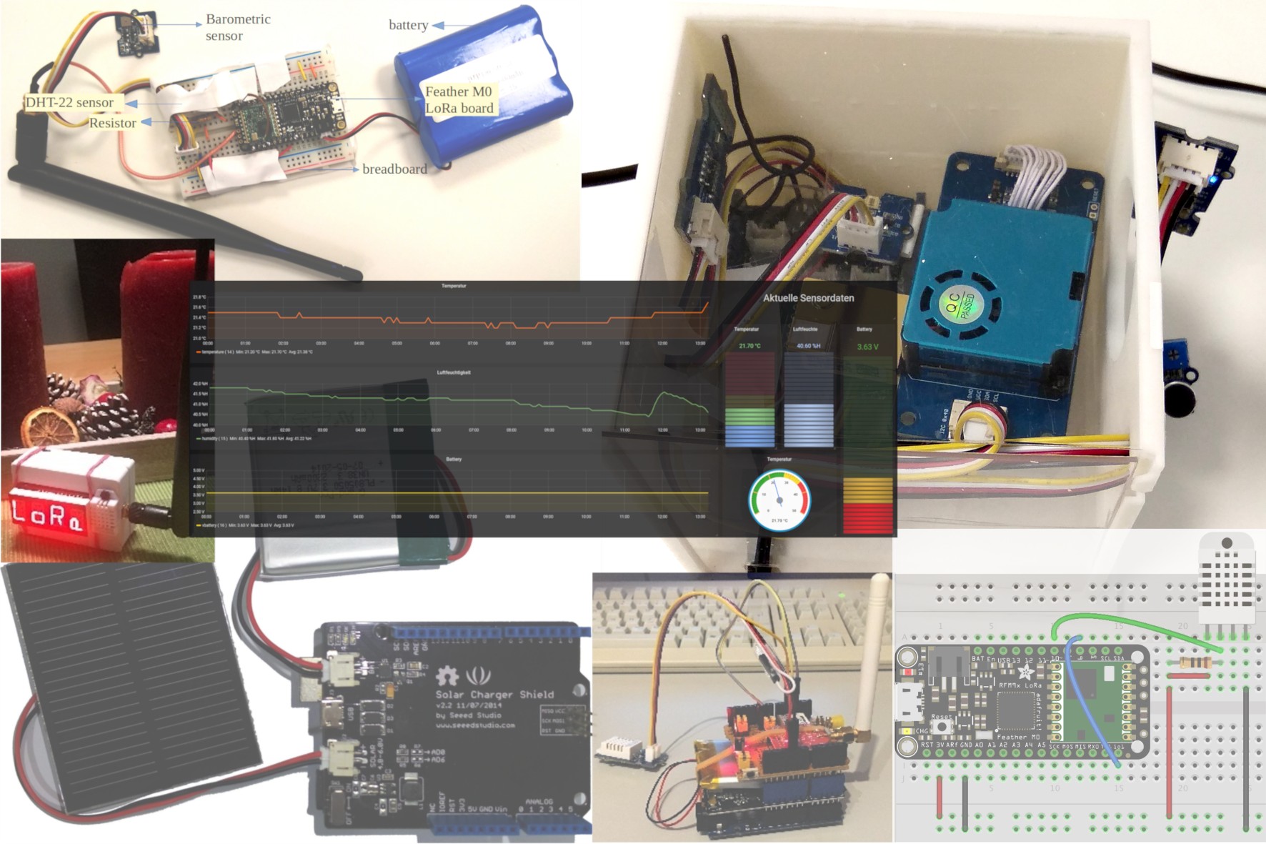
In this course you will learn the basics of IoT technology, microcontrollers, Low Power Wide Area Networking (LoRa) and the Geo Sensor Web using Open Source software, open standards and services. The course is strongly focused on a practical learning expericence where groups of students realize a small IoT project implementing all steps from hardware installation, programming of microcontrollers, reading sensor data, to sensor data management with open standards up to a finished IoT application, e.g. an online dashboard.
All groups members will receive an Arduino microcontroller and a set of low-cost sensors/actuators, with which they can realize individual projects such as indoor climate monitoring, automatic irrigation systems, fine dust measurements and many others. As networking technology we can use the city-wide available LoRaWAN infrastructure of Stadtwerke München.
Corona Virus
Due to the current restrictions the lecture will be held completely virtually. All lecture content is provided using a Wiki. The lectures will be held using video chat or video recordings. For course communication inside the student groups and with the course staff and tutors we use Slack. Tutors are availble to all course participants to provide support during the project.
The course hardware can be collected at TUM, Acrisstr. 21 or we will send it to you py post.
The current time table for the course is available here: https://wiki.tum.de/display/geosensorweb/Organization
Timetable
| Date | Room booking | Estimated duration | Staff | Content |
|---|---|---|---|---|
| 12.04.2021 | 13:30 - 14:00 | 30 min |
|
|
| 19.04.2021 | 13:30 - 15:00 | 1,5 h |
| Course organization
Introduction of staff Overview course content
|
| 26.04.2021 | 13:30 - 15:00 | 1,5 h |
| Theory: Introduction to IoT: Part I
Brief presentation of student projects |
| 03.05.2021 | 13:30 - 15:00 | 1,5 h |
| Theory: Introduction to IoT: Part II
Assign student projects and from groups |
| 10.05.2021 | 13:30 - 16:30 | 1,5 - 3 h |
| Practical exercise: Getting started with Microcontrollers (MC)
Homework
Tutoring session
|
| 17.05.2021 | 13:30 - 16:00 | 1,5 - 2,5 h |
| Theory: Introduction to LoRAWAN
Brief discussion of the homework Tutoring session
|
| 24.05.2021 | Pfingstmontag (frei) | |||
| 31.05.2021 | 13:30 - 15:00 | 1,5 h |
| Theory: Introduction to Geo Sensor Networks
Tutoring session
|
| 07.06.2021 | 13:30 - 15:00 | 1,5 h |
| Tutoring session
|
| 14.06.2021 | 13:30 - 18:00 | 2 - 3,5 h 15min break |
| Intermediate presentation (15 min, graded) |
| 21.06.2021 | 13:30 - 15:00 | 1,5 h |
| Tutoring session
|
| 28.06.2021 | 13:30 - 15:00 | 1,5 h |
| Tutoring session
|
| 05.07.2021 | 13:30 - 15:00 | 1,5 h |
| Tutoring session
|
| 12.07.2021 | 13:30 - 18:00 | 2 - 4 h 15min break |
| Final presentation (15 min, graded) |
Contact
For further questions please contact Bruno Willenborg
Geoinformatik 3 (Vorlesung)
| Vortragende/r (Mitwirkende/r) | |
|---|---|
| Umfang | 3 SWS |
| Semester | Sommersemester 2021 |
| Stellung in Studienplänen | Siehe TUMonline |
Termine
- 12.04.2021 13:30-17:30 Online: Videokonferenz / Zoom etc.
- 19.04.2021 13:30-17:30 Online: Videokonferenz / Zoom etc.
- 26.04.2021 13:30-17:30 Online: Videokonferenz / Zoom etc.
- 03.05.2021 13:30-17:30 Online: Videokonferenz / Zoom etc.
- 10.05.2021 13:30-17:30 Online: Videokonferenz / Zoom etc.
- 17.05.2021 13:30-17:30 Online: Videokonferenz / Zoom etc.
- 31.05.2021 13:30-17:30 Online: Videokonferenz / Zoom etc.
- 07.06.2021 13:30-17:30 Online: Videokonferenz / Zoom etc.
- 14.06.2021 13:30-17:30 Online: Videokonferenz / Zoom etc.
- 21.06.2021 13:30-17:30 Online: Videokonferenz / Zoom etc.
- 28.06.2021 13:30-17:30 Online: Videokonferenz / Zoom etc.
- 05.07.2021 13:30-17:30 Online: Videokonferenz / Zoom etc.
- 12.07.2021 13:30-17:30 Online: Videokonferenz / Zoom etc.
Teilnahmekriterien
Anmerkung: Teilnahmekriterien siehe "inhaltliche Voraussetzungen"