By activating external content from geoportal.bayern.de, you consent to transmitting data to this third party.
More Info
More Info
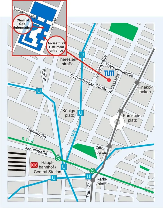
Getting there
By public transport
-
U-Bahn (subway)
- From the stop "Hauptbahnhof / Central Station" the U-Bahn line U2 runs every few minutes to Technische Universität München.
- Get off either at the stop "Königsplatz" or at the stop "Theresienstraße". From there follow the map to Technische Universität München.
-
Bus
- Bus Nr. 100 leaves every 10 minutes from stop "Hauptbahnhof Nord" and stops at "Technische Universität".
Further informationen on the public transport is available on the webpage of the Münchner Verkehrsverbund (MVV).
Alternatively, you can also walk from "Hauptbahnhof / Central Station" to Technische Universität München.
By train
Get off at the stop "München Hbf".
By plane
There are two possibilities to reach Munich Center from Munich Airport:
-
S-Bahn (suburban train)
- The S-Bahn lines S1 and S8 run to the city centre alternately every 10 minutes.
- Get off at the stop "Hauptbahnhof / Central Station".
- The travel time is approx. 45 minutes.
-
Lufthansa Airport Bus
- The bus departs every 20 minutes from Terminal 2, Terminal 1 Modul A, Terminal 1 Modul D and München Airport Center (MAC).
- Get off at the bus stop "Hauptbahnhof / Main train station".
- The travel time is approx. 40 minutes.