More than 50% of the world population is living in cities today and the number is further increasing. No matter if looking at environmental noise, air quality and particulate matter, energy usage and production, or traffic flows - in order to achieve or maintain a high quality of living in cities, municipalities and companies must take into account many different concerns simultaneously. The concept "Smart District Data Infrastructure" (SDDI) provides planners with the necessary set of flexible tools. Entire cities or just city districts are represented by 3D virtual city models which are linked with dynamic data, for example, on the traffic density or energy consumption. These models are used for monitoring and evaluation of the current situation, and especially for simulations of future developments and an early impact analysis.
Project description
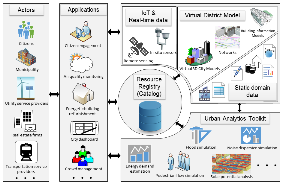
The SDDI has a modular structure and defines an organisational and technical framework consisting of actors, applications, sensors, an urban analytics toolkit, and a virtual district model. Actors are citizens and the city administration, but can also be other stakeholders like public transport services, utility service providers, and real estate firms. Sensors comprise local weather and climate stations, regional weather radar, smart meters for energy, gas, and water consumption, video cameras, and traffic sensors. Urban analytic tools are software components that, for example, estimate the energy demands or potentials of solar energy production for all buildings, simulate road traffic and pedestrian flows, or perform noise propagation or flooding simulations. The SDDI is based on Open Standards and links systems of different manufacturers in a non-proprietary and extensible way.
What makes the SDDI framework unique compared to others within the field of Smart Cities is the fact that all information, sensors, and applications are located within a semantic 3D city model. The latter is a virtual representation of the physical reality of the district. It consists of the most relevant objects like buildings, streets, vegetation, water bodies, and networks. The 3D model is based on the international standard CityGML and does not only serve for neat visualizations - it is an information hub and essential foundation for most simulations and analytic tools. Within this virtual district model, for example, the energy demands of buildings can be put in relation to their physical conditions and their socio-economic key performance indicators. This way, the impact of planned urban redevelopment projects on the different thematic fields like the environment, mobility, energy, and social affairs can be investigated at the same time.
Adoption throughout Europe
The SDDI has been developed to a large extent within the flagship project "Smart Sustainable Districts" (SSD) funded by the European research body Climate-KIC. The SSD project provides methods and tools to support urban redevelopment on the district scale. Major concerns are (among others) the reduction of emissions, increase of energy efficiency, usage of renewable energies, and the general improvement of the quality of living in cities. SDDI is being employed already in three ongoing large urban redevelopment projects:
London, Queen Elizabeth Olympic Park: This project is on the transformation of the district where the Olympic games 2012 took place to a new structure with mixed residential, recreational, and commercial usage.
Paris, Docks de St. Ouen: Brownfield development of a new district with residential and commercial usage on the territory of the former Paris docks next to the Seine river.
Berlin, Green Moabit: The focus lies on the energetic retrofitting of a large number of buildings and concepts for a more sustainable water management.
Due to the use of Open Standards most of the analysis tools and applications which are being developed for a specific district can be also employed by the other districts.
Securing the SDDI Framework - Demonstrator Application
The SDDI Security Demonstrator Application, developed by the Chair of Geoinformatics and Secure Dimension GmbH, presents a novel approach of securing distributed applications and web services being used in Smart City scenarios. The application has been realized for the district Queen Elizabeth Olympic Park, London as a part of the SDDI project.
The newly introduced concept establishes proper authorization and authentication to allow privacy, security and controlled access to all stakeholders and the respective components. The implementation combines the use of state-of-the-art concepts such as OAuth2 access tokens, OpenID Connect user claims and Security Assertion Markup Language (SAML) based Single-Sign-On (SSO) authentication. The application is conformant to the EU General Data Protection Regulation (GDPR).
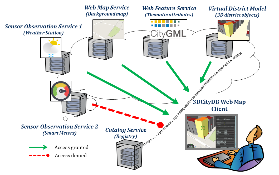
Virtual District Model based on the CityGML standard. It comprises of semantic 3D building and street models with spatial and thematic information stored in a 3D geodatabase.
Web Feature Service allowing users to retrieve as well as modify objects from the Virtual District Model stored in the 3D geodatabases using interoperable interfaces.
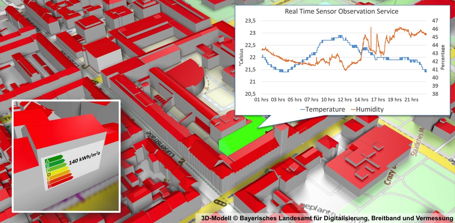
Sensor Observation Service 1 retrieving real-time observations from a weather station installed in the park. The weather station records properties such as temperature, humidity, wind speed etc.
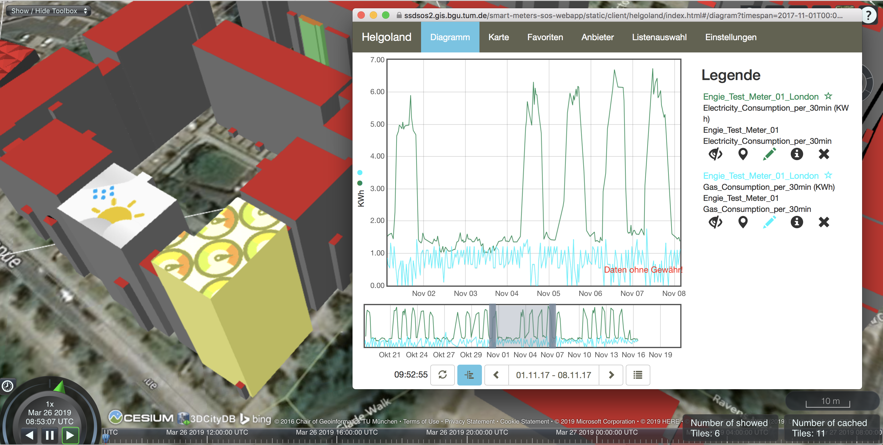
Sensor Observation Service 2 retrieving real-time observations from Smart Meters installed in important buildings such as stadium and aquatic center. The Smart Meters are managed within a proprietary platform of the company Engie and record electricity and gas consumptions for the buildings.
3DCityDB Web Map Client is a web-based front-end for the 3D City Database for 3D visualization and interactive exploration of large semantic 3D city models in CityGML.
Demonstrator Objectives
The demonstrator provides
security layers to all of the resources, so that no resource can be accessed without proper authentication and authorization,
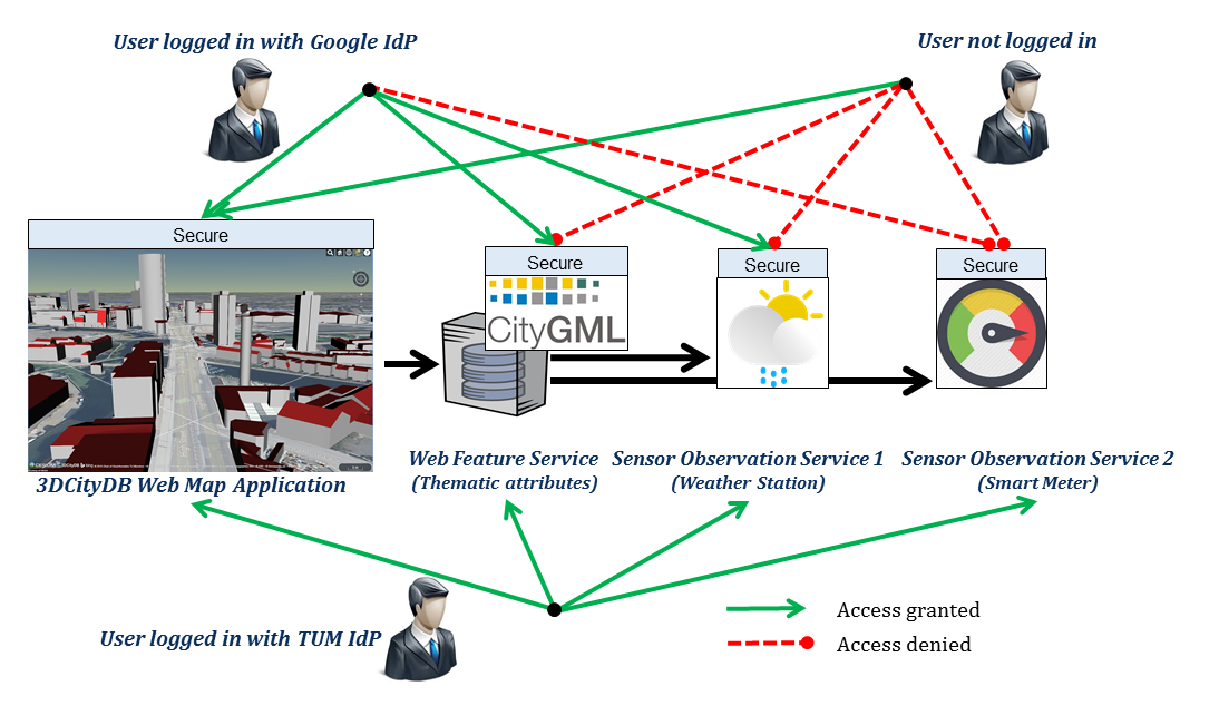
federated login and Single-Sign-On access using different Identity Providers. This is demonstrated by showing that users can login using academic identity federations (such as eduGAIN service supporting approximately 2758 university identity providers worldwide) and public accounts (such as Google accounts) to all the secured resources hosted on distributed systems without repetitive logins, and
access control to all the secured resources. Users can login via two different classes of identity providers: (i) a valid public account (e.g. Google) and (ii) a valid academic organization account linked to eduGAIN. In the scenario, if a user is not logged in, he/she can browse/view the 3D models but cannot connect to any further resource. Users logged in using the Google Identity Provider can access all resources except Sensor Observation Service 2 for Smart Meters, while users logged in using an eduGAIN based research organization's Identity Provider will be able to access all resources.
Below is a screenshot from the application visualizing a highlighted building (where Smart Meter is installed) and the timeseries observation graph for one week (retrieved from Sensor Observation Service for the Smart Meter).
Project sponsors
Climate-KIC of the EIT. Climate-KIC is a Knowledge and Innovation Community about Climate Change and Mitigation. It is one of three Knowledge and Innovation Communities (KICs) created in 2010 by the European Institute of Innovation and Technology (EIT). The EIT is an EU body whose mission is to create sustainable growth.
In the project Smart Sustainable Districts in general
Imperial College London, Centre for Process Systems Engineering, Prof. Nilay Shah
Technische Universität Berlin, CHORA City & Energy, Prof. Raoul Bunschoten
University of Utrecht
Chalmers University of Technology
Utrecht Sustainability Institute (USI)
Institute for Sustainability London
Aria
TNO
In the district London, Queen Elizabeth Olympic Park (QEOP)
Imperial College London, Centre for Process Systems Engineering, Prof. Nilay Shah, Dr. Chris Mazur
University College London, The Bartlett Centre for Advanced Spatial Analysis (CASA), Prof. Andrew Hudson-Smith, Oliver Dawkins
London Legacy Development Corporation (LLDC), Jim Wood, Ben Edmonds
Intel Labs Europe, ICRI Cities, Dr. Evangelos Theodoridis, Dr. Mo Haghighi
Engie
In the district Paris, Docks de St. Ouen (NUM-DOCKS)
Aria, Denis Morin, Corinne Krzyzamiak
Sequano
In the district Berlin Moabit
Technische Universität Berlin, CHORA City & Energy, Prof. Raoul Bunschoten, Nadine Kuhla von Bergmann, Daniel Rigamonti
Award in the contest "Germany - Land of Ideas"
As one of 100 winners from about 1000 candidates the project has been awarded "Landmarks in the Land of Ideas" 2016. The goal of the "Germany – Land of Ideas" initiative and Deutsche Bank is to make innovations visible in Germany and abroad and to strengthen the economic potential and sustainability of Germany as a location. This year, in 2016, the competition "CommUnityInnovation – a model for success" is awarding projects that show the added value and potential of joint action, whether in business partnering, scientific networks, or neighbourhood initiatives.
Knezevic, Marija; Donaubauer, Andreas; Moshrefzadeh, Mandana; Kolbe, Thomas H.: Managing Urban Digital Twins with an Extended Catalog Service. Proceedings of the 7th International Smart Data and Smart Cities (SDSC) Conference 2022 (ISPRS Annals of the Photogrammetry, Remote Sensing and Spatial Information Sciences), 2022 more…BibTeX
Meyer, Markus: Interactive Retrieval and Exploration of Information Resources by Coupling of a 3D Web Viewer and a Smart City Catalog Service. Master thesis, 2022 more…BibTeX
2021
Deigele, W; Donaubauer, A.; Moshrefzadeh, M.; Kolbe T. H.: Leitfaden – Geobasierter Digitaler Zwilling nach der SDDI-Methode. , Ed.: Bayern Innovativ, ZD.B – Themenplattform Smart Cities and Regions: Bayern Innovativ, ZD.B – Themenplattform Smart Cities and Regions, 2021, more…BibTeX
2019
Chaturvedi, Kanishk; Kolbe, Thomas H.: A Requirement Analysis on Extending Semantic 3D City Models for Supporting Time-dependent Properties. Proceedings of the 4th International Conference on Smart Data and Smart Cities (ISPRS Archives of the Photogrammetry, Remote Sensing and Spatial Information Sciences ), ISPRS, 2019 more…BibTeX
Chaturvedi, Kanishk; Kolbe, Thomas H.: Towards Establishing Cross-Platform Interoperability for Sensors in Smart Cities. Sensors 19(3) (Special Issue Selected Papers from ISC2 2018), 2019, 29 more…BibTeX
Chaturvedi, Kanishk; Matheus, Andreas, Nguyen, Son H., Kolbe, Thomas H.: Securing Spatial Data Infrastructures For Distributed Smart City Applications and Services. Future Generation Computer Systems 101 (Special Issue on Security & Biometrics), 2019 more…BibTeX
Chaturvedi, Kanishk; Yao, Zhihang; Kolbe, Thomas H.: Integrated Management and Visualization of Static and Dynamic Properties of Semantic 3D City Models. Proceedings of the 4th International Conference on Smart Data and Smart Cities (ISPRS Archives of the Photogrammetry, Remote Sensing and Spatial Information Sciences), ISPRS , 2019 more…BibTeX
2018
Chaturvedi, Kanishk; Kolbe, Thomas H.: InterSensor Service: Establishing interoperability over heterogeneous Sensor Observations and Platforms for Smart Cities. 4th IEEE Annual International Smart Cities Conference (ISC2) 2018, 2018 more…BibTeX
Chaturvedi, Kanishk; Matheus, Andreas; Nguyen, Son H.; Kolbe, Thomas H.: Securing Spatial Data Infrastructures in the Context of Smart Cities. 2018 International Conference on CYBERWORLDS (CW 2018), 2018, 403-408 more…BibTeX
Graßl, Teresa: Implementierung eines WebGIS zur Darstellung von Untergrunddaten. Projekt thesis, 2018 more…BibTeX
Kutzner, Tatjana; Donaubauer, Andreas; Kolbe, Thomas H.: UML-Profiles and their use in data modelling and model-driven transformation of geospatial data. gis.Science (4), 2018 more…BibTeX
2017
Kammel, Frederik: Visualizing raster data at different time intervals using OGC Web Map Service. Bachelor thesis, 2017 more…BibTeX
Marx, Caroline; Donaubauer, Andreas; Fiutak, Georg; Kolbe, Thomas H.: Digitales Landschaftsmodell in 3D. In: Kolbe, Thomas H.; Bill, Ralf; Donaubauer, Andreas (Ed.): Geoinformationssysteme 2017 – Beiträge zur 4. Münchner GI-Runde. Wichmann Verlag, 2017 more…BibTeX
Ostermann, Adrian; Schmidt, Marcel: Entwicklung einer kostengünstigen und kompakten Sensor-Messstation zur Prozessdatenerfassung und Einbindung der Daten in einen Sensor Observation Service. Semester thesis, 2017 more…BibTeX
2016
Donaubauer, Andreas; Kolbe, Thomas H. (Ed.): Leitfaden Bezugssystemwechsel auf ETRS89/UTM – Grundlagen, Erfahrungen und Empfehlungen. Runder Tisch GIS e.V., 2016 more…BibTeX
Aringer, Klement; Donaubauer, Andreas; Roschlaub, Robert; Kolbe, Thomas H.: Modellbasierte Transformation von 3D-Gebäudemodellen nach INSPIRE. Zeitschrift für Geodäsie, Geoinformation und Landmanagement (3), 2016 more…BibTeX
2015
Chaturvedi, Kanishk; Kolbe, Thomas H.: Dynamizers - Modeling and implementing dynamic properties for semantic 3D city models. Eurographics Workshop on Urban Data Modelling and Visualisation, 2015 more…BibTeX
2014
Fischl, Gerhard: Implementierung eines OGC konformen Web Processing Service (WPS) als Geodesign-Tool zur Abschätzung des Einzugsgebiets von Biogasanlagen. Semester thesis, 2014 more…BibTeX
Kutzner, Tatjana; Donaubauer, Andreas; Müller, Michael; Feichtner, Astrid; Goller, Steffen: Erfolgreiche Transformation von Geodaten nach INSPIRE in der grenzüberschreitenden Region Bodensee. zfv - Zeitschrift für Geodäsie, Geoinformation und Landmanagement (2), 2014, 103-109 more…BibTeX
Schilcher, Matthäus: Grenzüberschreitende Geodaten – "Geodatenpool Bodensee". In: Kummer, Klaus; Kötter, Theo; Eichhorn, Andreas (Ed.): Das deutsche Vermessungs- und Geoinformationswesen 2015. Wichmann, 2014, 27-32 more…BibTeX
Steuer, Horst; Flurl, Matthias; Donaubauer, Andreas; Mundani, Ralf-Peter; Kolbe, Thomas H.; Rank, Ernst: Collaborative Planning of Inner-City-Railway-Tracks: A Generic Description of the Geographic Context and Its Dynamic Integration in a Collaborative Multi-Scale Geometry Modelling Environment. Advanced Engineering Informatics 28, 2014, 261–271 more…BibTeX
2013
Gröger, Gerhard; Kutzner, Tatjana; Kolbe, Thomas H.: A CityGML-based encoding for the INSPIRE Data Specification on Buildings. INSPIRE Conference 2013, 2013 more…BibTeX
Höfer, Maximilian: Automatisierter Prozess für die Lärmdatenverarbeitung mit Hilfe von novaFACTORY und FME. Master thesis, 2013 more…BibTeX
Schließer, Andreas: Entwicklung eines Web-basierten Clients für ein Geodesign-System. Bachelor thesis, 2013 more…BibTeX
Steuer, Horst; Donaubauer, Andreas: Kopplung von Systemen der Geo- und der Bauinformatik zur kollaborativen 3D Trassenplanung. Dreiländertagung D - A - CH 33. Wissenschaftlich-Technische Jahrestagung der DGPF, 2013 more…BibTeX
Steuer, Horst; Donaubauer, Andreas; Kolbe, Thomas H.; Flurl, Matthias; Mundani, Ralf-Peter; Rank, Ernst: Planning Inner-City-Railway-Tracks: Dynamic Integration of Geospatial Web Services in a Collaborative Multi-Scale Geometry Modelling Environment. EG-ICE Workshop on Intelligent Computing in Civil Engineering, 2013 more…BibTeX
2012
Breunig, Martin; Borrmann, André; Rank, Ernst; Schilcher, Matthäus; Hinz, Stefan; Donaubauer, Andreas; Mundani, Ralf-Peter: Towards 3D Geoinformatics and Computational Civil Engineering Support for Cooperative Tracks Planning. Proceedings of FIG Working Week 2012, 2012 more…BibTeX
Kutzner, Tatjana: Vergleichende Untersuchungen zur Modellierung und semantischen Modelltransformation in der Region Bodensee. Geoinformationssysteme, Beiträge zum 17. Münchner Fortbildungsseminar 2012, Wichmann, 2012, 61-72 more…BibTeX
Kutzner, Tatjana; Donaubauer, Andreas: Critical Remarks on the Use of Conceptual Schemas in Geospatial Data Modelling - A Schema Translation Perspective. Bridging the Geographic Information Sciences (Lecture Notes in Geoinformation and Cartography), Springer, 2012International AGILE'2012 Conference, Avignon (France), April, 24-27, 2012, 43-60 more…BibTeX
Kutzner, Tatjana; Schilcher, Matthäus; Aderhold, Bianca: INSPIRE auf dem Prüfstand der grenzüberschreitenden Praxistauglichkeit in der Testregion Bodensee. Angewandte Geoinformatik 2012, Wichmann, 2012Beiträge zum 24. AGIT-Symposium Salzburg, 181-190 more…BibTeX
Donaubauer, Andreas; Kutzner, Tatjana; Straub, Florian: Model-driven Semantic Transformation – a Report on Work in Progress. In: Schilcher, Matthäus (Ed.): INSPIRE-GMES Information Brochure. Technische Universität München, Geodätisches Institut (7th completely revised, extended and updated edition. edn.), 2011, 52-53 more…BibTeX
Kutzner, Tatjana: Zweiter Workshop "Semantische Modelltransformation im Kontext von INSPIRE. In: Schilcher, Matthäus (Ed.): INSPIRE-GMES-Informationsbroschüre. Technische Universität München, Geodätisches Institut (7. vollständig überarbeitete und aktualisierte Auflage. edn.), 2011, 65-66 more…BibTeX
Kutzner, Tatjana: Second Workshop „Semantic Schema Translation in the context of INSPIRE“. In: Schilcher, Matthäus (Ed.): INSPIRE-GMES Information Brochure. Technische Universität München, Geodätisches Institut (7th completely revised, extended and updated edition. edn.), 2011, 56-57 more…BibTeX
Lill, Michael; Kutzner, Tatjana; Fünfer, Hubert: Erfahrungen mit semantischer Transformation auf Basis heute verfügbarer Software. In: Schilcher, Matthäus (Ed.): INSPIRE-GMES-Informationsbroschüre. Technische Universität München, Geodätisches Institut (7. vollständig überarbeitete und aktualisierte Auflage. edn.), 2011, 56-59 more…BibTeX
Lill, Michael; Kutzner, Tatjana; Fünfer, Hubert: Experience with Semantic Transformation Based on Currently Available Software. In: Schilcher, Matthäus (Ed.): INSPIRE-GMES Information Brochure. Technische Universität München, Geodätisches Institut (7th completely revised, extended and updated edition. edn.), 2011, 49-51 more…BibTeX
Schönherr, Hansjörg; Schilcher, Matthäus; Illert, Andreas; Kutzner, Tatjana; Heß, Dieter: Grenzüberschreitende Transformation von Geodaten nach INSPIRE in der Region Bodensee - Herausforderung für Verwaltung, Wirtschaft und Wissenschaft. In: Schilcher, Matthäus (Ed.): INSPIRE-GMES-Informationsbroschüre. Technische Universität München, Geodätisches Institut (7. vollständig überarbeitete und aktualisierte Auflage. edn.), 2011, 51-55 more…BibTeX
Schönherr, Hansjörg; Schilcher, Matthäus; Illert, Andreas; Kutzner, Tatjana; Heß, Dieter: Cross-border Transformation of Spatial Data to INSPIRE in the Lake Constance Region – Challenge for Administration, Industry and Science. In: Schilcher, Matthäus (Ed.): INSPIRE-GMES Information Brochure. Technische Universität München, Geodätisches Institut (7th completely revised, extended and updated edition. edn.), 2011, 44-48 more…BibTeX
2010
Banfi, Daniel; Fünfer, Hubert; Kutzner, Tatjana: Von ALKIS und ATKIS zu INSPIRE. In: Schilcher, Matthäus (Ed.): INSPIRE-GMES-Informationsbroschüre. Technische Universität München, Geodätisches Institut (6. vollständig überarbeitete und aktualisierte Auflage. edn.), 2010, 40-42 more…BibTeX
Donaubauer, Andreas; Kutzner, Tatjana; Gnägi, Hans Ruedi; Henrich, Stefan; Fichtinger, Astrid: Webbasierte Modelltransformation in der Geoinformatik. Modellierung 2010, Gesellschaft für Informatik, 2010, 269-284 more…BibTeX
Donaubauer, Andreas; Straub, Florian: A Spatial Decision Service for BPEL. ISPRS Workshop on Pervasive Web Mapping, Geoprocessing and Services - WebMGS 2010, 2010 more…BibTeX
Eisenhut, Claude; Kutzner, Tatjana: Vergleichende Untersuchungen zur Modellierung und Modelltransformation in der Region Bodensee im Kontext von INSPIRE. In: Schilcher, Matthäus (Ed.): INSPIRE-GMES-Informationsbroschüre. Technische Universität München, Geodätisches Institut (6. vollständig überarbeitete und aktualisierte Auflage. edn.), 2010, 34 more…BibTeX
Fichtinger, Astrid; Kutzner, Tatjana: Datenharmonisierung im Kontext von INSPIRE. Geoinformationssysteme - Beiträge zum 15. Münchner Fortbildungsseminar, abcverlag, 2010, 30-46 more…BibTeX
Krüger, Andreas; Kolbe, Thomas H.: A Framework for the Data-Driven Analysis, Interpretation, and Transformation of Geospatial Information Models. Proceedings of the Joint Scientific Conference of the German Society for Photogrammetry, Remote Sensing & Geoinformation (DGPF), the Austrian Society for Surveying (OVG), and the Swiss Society for Photogrammetry and Remote Sensing (SGPF), Vienna 2010, Deutsche Gesellschaft für Photogrammetrie, Fernerkundung und Geoinformation e.V., 2010 more…BibTeX
Kutzner, Tatjana: Semantische Transformation am Beispiel der Testregion Bodensee. In: Schilcher, Matthäus (Ed.): INSPIRE-GMES-Informationsbroschüre. Technische Universität München, Geodätisches Institut (6. vollständig überarbeitete und aktualisierte Auflage. edn.), 2010, 35-36 more…BibTeX
Kutzner, Tatjana: The Unified Modeling Language for the Translation of Spatial Data on Conceptual Level - Challenges and Limitations. Proceedings of the GIScience 2010 Doctoral Colloquium, Akademische Verlagsgesellschaft AKA, 2010, 55-58 more…BibTeX
Kutzner, Tatjana; Eisenhut, Claude: Vergleichende Untersuchungen zur Modellierung und Modelltransformation in der Region Bodensee im Kontext von INSPIRE. Technische Universität München, Geodätisches Institut, 2010 more…BibTeX
Schilling, Arne; Kolbe, Thomas H.: Candidate OpenGIS® Web 3D Service Interface Standard Version 0.4.0. Open Geospatial Consortium Discussion Paper, OGC Doc. No. 09-104r1, 2010 more…BibTeX
2009
Donaubauer, Andreas; Fichtinger, Astrid; Kutzner, Tatjana: Semantische Transformation als Geo Web Service. Mitteilungen des Bundesamtes für Kartographie und Geodäsie, Verlag des Bundesamtes für Kartographie und Geodäsie, 2009Arbeitsgruppe Automation in Kartographie, Photogrammetrie und GIS, Tagung 2008, 67-82 more…BibTeX
Donaubauer, Andreas; Fichtinger, Astrid; Kutzner, Tatjana; Schilcher, Matthäus: Semantische Modelltransformation im Kontext von INSPIRE. Newsletter e-geo.ch (22), 2009, 10-13 more…BibTeX
2008
Donaubauer, Andreas; Fichtinger, Astrid; Kutzner, Tatjana: Semantische Transformation als Geo Web Service. Bundesamt für Kartographie und Geodäsie, (Mitteilungen des BKG Band 43: Arbeitsgruppe Automation in Kartographie, Photogrammetrie und GIS Tagung 2008 ), 2008, more…BibTeX
Donaubauer, Andreas; Straub, Florian; Fichtinger, Astrid; Staub, Peter: Web-basierte Modelltransformation - eine Lösung für INSPIRE? GIS Zeitschrift für Geoinformatik, 2008 more…BibTeX
Donaubauer, Andreas; Straub, Florian; Stahl, Julia: Service Orientierte Architektur für das Prozessdatenmanagement zur Unterstützung einer freiwilligen Selbstkontrolle im Pflanzenschutz. Elektronische Zeitschrift für Agrarinformatik, 2008 more…BibTeX
Schilcher, Matthäus; Donaubauer, Andreas; Carosio, Alessandro; Fichtinger, Astrid; Henrich, Stefan; Staub, Peter; Kutzner, Tatjana: Projekt mdWFS, Phase III – Abschlussbericht. Bundesamt für Kartographie und Geodäsie, 2008, more…BibTeX
2007
Carosio, Alessandro; Schilcher, Matthäus; Donaubauer, Andreas; Morf, Andreas; Staub, Peter; Straub, Florian: Projekt mdWFS, Phase II – Abschlussbericht. Bundesamt für Kartographie und Geodäsie und swisstopo, 2007, more…BibTeX
Donaubauer, Andreas; Kraut, Volker; Leonhardt, Axel; Schilcher, Matthäus: Kapselung von Simulationsmodellen durch Geo Web Services - Erfahrungen mit einem Echtzeitverkehrsmodell. GIS Zeitschrift für Geoinformatik, 2007 more…BibTeX
Donaubauer, Andreas; Kraut, Volker; Wanderer, Thomas; Drews, M.: Kopplung Google Earth und OGC Web Services für Anwendungen im Katastrophenmanagement, in der Verkehrstelematik sowie für 3D Stadtmodelle – Abschlussbericht. Runder Tisch GIS e.V., 2007, more…BibTeX
Donaubauer, Andreas; Straub, Florian; Schilcher, Matthäus: mdWFS: A Concept of Web-enabling Semantic Transformation. 10th AGILE International Conference on Geographic Information Science, 2007 more…BibTeX
2006
Carosio, Alessandro; Schilcher, Matthäus; Donaubauer, Andreas; Morf, Andreas; Staub, Peter; Straub, Florian: Projekt mdWFS, Phase I – Abschlussbericht. Bundesamt für Kartographie und Geodäsie und swisstopo, 2006, more…BibTeX
Cetl, Vlado; Matijevic, H.; Donaubauer, Andreas: Spatial Data Infrastructure in Germany - the Example of Bavaria. Geodetski List 60 (83) (4), 2006 more…BibTeX
Donaubauer, Andreas; Fichtinger, Astrid; Schilcher, Matthäus; Straub, Florian: Model Driven Approach for Accessing Distributed Spatial Data Using Web Services. XXIII International FIG Congress, 2006 more…BibTeX
Schilcher, Matthäus; Donaubauer, Andreas; Fichtinger, Astrid; Straub, Florian: Einsatz von Geo Web Services für den Aufbau von nationalen und transnationalen Geodateninfrastrukturen. GIS/SIT 2006, 2006 more…BibTeX
2005
Donaubauer, Andreas: A Multi-Vendor Spatial Data Infrastructure for Local Governments based on OGC Web Services. FIG Working Week 2005 and 8th International Conference on the Global Spatial Data Infrastructure, 2005 more…BibTeX
Donaubauer, Andreas: Leistungsfähigkeit von OGC Web Services für herstellerübergreifende Geodateninfrastrukturen. 10. Münchner Fortbildungsseminar Geoinformationssysteme, 2005 more…BibTeX
Donaubauer, Andreas; Straub, Florian: Web Spatial Analysis Service (WSAS) - Dienst zur Analyse von Geodaten aus verteilten Quellen. Runder Tisch GIS e.V., 2005, more…BibTeX
Quadt, Udo; Kolbe, Thomas H.: OpenGIS® Web 3D Service Interface Standard Version 0.3.0. 2005 more…BibTeX
Schilcher, Matthäus; Donaubauer, Andreas: OGC Specifications for Access to Distributed Geospatial Data. Photogrammetric Week '05, Wichmann, 2005 more…BibTeX
Schilcher, Matthäus; Plabst, Stephan; Donaubauer, Andreas: Nutzung verteilter Geodaten in Kommunen. 9. Internationales Anwenderforum für Geoinformationssysteme, 2005 more…BibTeX
2004
Donaubauer, Andreas: OGC Web Feature Service - Geodienst für den Zugriff auf objektstrukturierte Geodaten. In: Bernard, Lars; Fitzke, Jens; Wagner, Roland M. (Ed.): Geodateninfrastruktur. Wichmann, 2004 more…BibTeX
Donaubauer, Andreas; Kunkel, Thorsten; Schilcher, Matthäus; Teege, Gunnar: OGC Web Services zur interoperablen Nutzung verteilter Geodatenbanken für die Immobilienwirtschaft. In: Bernard, Lars; Fitzke, Jens; Wagner, Roland M. (Ed.): Geodateninfrastruktur. Wichmann, 2004 more…BibTeX
Donaubauer, Andreas; Schilcher, Matthäus: Online-Leitungsauskunft bei verteilten Systemen. Geobit - Geoinformatik für die Praxis, 2004 more…BibTeX
Donaubauer, Andreas; Straub, Florian; Löwis of Menar, Oliver: Webbasierte Verschneidung verteilter Geodaten für die forstliche Standorterkundung. Geobit - Geoinformatik für die Praxis, 2004 more…BibTeX
Kolbe, Thomas H.: Interoperable 3D-Geovisualisierung – 28. In: Bernard, Lars; Fitzke, Jens; Wagner, Roland (Ed.): Geodateninfrastruktur - Grundlagen und Anwendungen. Wichmann Verlag, 2004, 247--257 more…BibTeX
2003
Altmaier, Angela; Kolbe, Thomas H.: Applications and solutions for interoperable 3D geo-visualization. Proceedings of the Photogrammetric Week 2003 in Stuttgart, Wichmann Verlag, 2003 more…BibTeX
Aumann, Gabriele; Donaubauer, Andreas; Kunkel, Thorsten; Schilcher, Matthäus: OGC Web Services zur interoperablen Nutzung verteilter Geodatenbanken für mobile Anwendungen. GIS Zeitschrift für Geoinformatik (06/2003), 2003 more…BibTeX
Donaubauer, Andreas: Piloting Open GIS in Germany. A Multi-Vendor Test of the OGC WMS Specification. GeoSpatial World 2003, 2003 more…BibTeX
Donaubauer, Andreas; Jaenicke, Kathrin: Konzeption und Implementierung eines internetbasierten Geoinformationssystems zur Führung eines Ökokontos. Zeitschrift für Vermessungswesen: ZfV, 2003 more…BibTeX
Donaubauer, Andreas; Kunkel, Thorsten; Schilcher, Matthäus: Mobile Liegenschaftsauskunft auf der Basis von OGC Web Services. Münsteraner GI-Tage 2003, 2003 more…BibTeX
Donaubauer, Andreas; Seuß, Robert: Neueste GIS-Trends; T. 4: Offen ist die Zukunft. Kommune21, 2003 more…BibTeX
2002
Donaubauer, Andreas; Matheus, Andreas: Verkettung von Geodiensten auf der Basis von Web Services. Informatik 2002 - 32. Jahrestagung der Gesellschaft für Informatik r.V. (GI), 2002 more…BibTeX
Schilcher, Matthäus; Donaubauer, Andreas: Zum GIS-Bedarf im kommunalen Bereich. In: Bill, Ralf (Ed.): Kommunale Geo-Informationssysteme. Wichmann, 2002 more…BibTeX