- Development of an Automated Transformation Method of GB Road Network Data for Connected and Automated Mobility Applications. Master thesis, 2023 more… BibTeX
- Validation of Parametric OpenDRIVE Road Space Models. Proceedings of the 17th International 3D GeoInfo Conference 2022 (ISPRS Annals of the Photogrammetry, Remote Sensing and Spatial Information Sciences), 2022 more… BibTeX
- Identifikation von geometrischen Abweichungen zwischen semantischen Stadtmodellen und Punktwolken. Bachelor thesis, 2021 more… BibTeX
- Plastic Surgery for 3D City Models: A Pipeline for Automatic Geometry Refinement and Semantic Enrichment. ISPRS Annals of the Photogrammetry, Remote Sensing and Spatial Information Sciences, Copernicus GmbH, 2021ISPRS Congress 2021, 17-24 more… BibTeX
- Spatio-Semantic Road Space Modeling for Vehicle–Pedestrian Simulation to Test Automated Driving Systems. Sustainability 12 (9), 2020, 3799 more… BibTeX
- Semantic-based Geometry Refinement of 3D City Models for Testing Automated Driving. Master thesis, 2020 more… BibTeX
- Requirement Analysis of 3D Road Space Models for Automated Driving. ISPRS Annals of Photogrammetry, Remote Sensing and Spatial Information Sciences IV-4/W8, 2019, 99-106 more… BibTeX
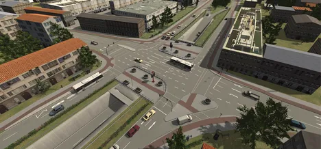
In order to test and ensure the safety of automated and connected driving, a virtual test field is required which enables the efficient simulation of a vast amount of traffic scenarios. The objective of this research project is the development of a multifunctional regional model. Therefore a digital twin of the city Ingolstadt is created and infrastructural elements (traffic lights, induction loops, …) as well as floating car data are connected to the city model.
Project description
The development of automated and connected driving is a complex and difficult endeavor due to the large number of different traffic scenarios. In order to test automated driving, these functions are exposed to different traffic scenarios within a virtual test field. The simulation of the environment enables the testing of scenarios in an automated, efficient and reproducible manner.
The objective of this research project is the methodical creation of a validated environment model for the development of automated and connected driving with a focus on urban spaces in order to conduct driving and traffic simulations. Furthermore, societal questions regarding the acceptance of automated driving and regional models are investigated. The project is propelled by a consortium of ten partners and is structured in five main topics:
- Extending and developing driving simulation in virtual test fields
- Connecting the infrastructure and real floating car data to a virtual traffic model
- Optimization of automated driving functions
- Societal aspects of automated and connected driving
- Transversal tasks (data models, use cases, demonstrators)