Completed Projects
The Chair of Geoinformatics has successfully completed a variety of projects. More information about each project can be found on the individual project pages.
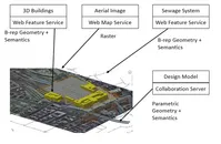
Future Cities Pilot Phase 1

The "Future Cities Pilot" (FCP), an initiative by Open Geospatial Consortium (OGC), aims at demonstrating and enhancing the ability of spatial data infrastructures to support quality of life, civic initiatives and urban resilience. The first phase of this pilot project (termed FCP1) is based in Europe and is sponsored by Ordnance Survey Great Britain, Institut National de l'Information Géographique et Forestière (IGN) France, city of Sant Cugat del Vallès (Barcelona), Spain and virtualcitySYSTEMS GmbH Berlin and in collaboration with buildingSMART International (bSI). The objective of the OGC pilot project is to demonstrate how use of, international standards such as CityGML and IFC together can provide stakeholders with information, knowledge and insight which enhances financial, environmental, and social outcomes for citizens living in cities. Results from this initiative will be documented in Engineering Reports (ERs) in the context of a hands-on engineering experience. This initiative is aimed to develop, test, identify gaps and demonstrate the use of these technologies in a real world-type scenario developed in collaboration with the sponsors. The final demonstrations will be presented in Smart City Expo in Barcelona in November, 2016. [more...]
Semantic 3D Landscape Model Vorarlberg (VoDLM3D)
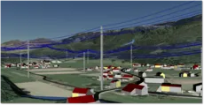
The demand for three-dimensional city and landscape models is increasing steadily. For instance, they are used for production site analyses or simulations of natural hazards. Although in some use cases visual representation would be sufficient, however, there are numerous case studies that require considering the semantic aspect of the landscape model as well. For this purpose, a pilot project was started at TUM in cooperation of the Land Vorarlberg and the company virtualcitySYSTEMS (VCS), aiming for the generation of a semantically evaluable three-dimensional digital landscape model. [more...]
3D Tracks
The DFG research group "Computer-aided cooperative planning in multi-scale 3D city and building models" aims at researching and developing methods and techniques for cooperative planning of infrastructure. The project involves five groups at the Technical University of Munich and the Karlsruhe Institute of Technology.
The sub-project "advanced geo-web services for the requirements of multi-scale 3D-route planning" belongs to the Chair of Geoinformatics. [more...]
Geodata Pool Lake Constance
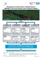
The mapping and cadastre authorities of Baden-Wuerttemberg, Bavaria, Austria and Switzerland launched a pilot project which aims at prototypically transforming the topographical data together with the cadastre data to the INSPIRE data models from Annex I of the INSPIRE Directive using semantic transformation and to provide them via view and download services. The semantic transformation is executed by means of two different approaches, the format-driven approach as well as the model-driven approach. [more...]
Model-driven approach for accessing distributed spatial data using Web Services – demonstrated for cross-border GIS applications (mdWFS)
The project aims at developing an approach for web-based schema transformation of geospatial data. It includes the specification of a conceptual language for defining schema mapping rules for semantic transformation as well as the specification of an interface for a model-driven web service able to carry out semantic transformation. [more...]
Prototypische Enwticklung Mobiler Anwendungen im Kontext von INSPIRE und COPERNICUS (InGeoSat 2)
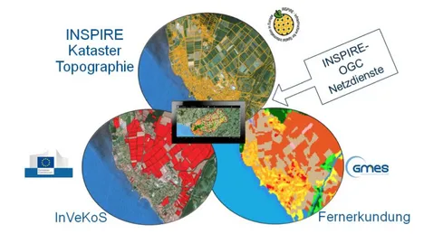
Ziel dieses Projekts ist die Entwicklung einer prototypischen Anwendung auf Basis einer mobilen GIS-Plattform. Unter dem Android Betriebssystem wird eine native Android-Applikation implementiert, mit welcher primär INSPIRE, COPERNICUS und InVeKoS-Daten visualisiert werden. Zudem besteht die Möglichkeit über standardisierte OGC- und INSPIRE-Webdienste externe Geodaten einzuladen. Die Potentiale der mobilen Plattform werden anhand einfacher Funktionalitäten der Applikation aus den Bereichen Flurbereinigung, Kataster und Landnutzung sowie der Kombination von INSPIRE- Datenstrukturen mit Fernerkundungsdaten (COPERNICUS) und Landnutzungsdaten (InVeKoS) aufgezeigt. [mehr...]
VerNet-LEM

The goal of this project is to provide a small-scale, climate-dependent forecast for feed-in power and consumption and, as a result, an assessment of the compatibility of the calculated loads and services with the components and lines installed in the distribution network. In a further step, the measures to be taken are then to be simulated and evaluated with an increased feed load or consumption. In the end, a forecasting and simulation system is to be developed, which allows network operators to optimise operation in distribution networks. [more...]