Semantic 3D Landscape Model Vorarlberg (VoDLM3D)


The demand for three-dimensional city and landscape models is increasing steadily. For instance, they are used for production site analyses or simulations of natural hazards. Although in some use cases visual representation would be sufficient, however, there are numerous case studies that require considering the semantic aspect of the landscape model as well.

For this purpose, a pilot project was started at TUM in cooperation of the Land Vorarlberg and the company virtualcitySYSTEMS (VCS), aiming for the generation of a semantically evaluable three-dimensional digital landscape model.


Demo Video

Please note: When playing back the YouTube video, personal data is collected and transferred to Google.

3D-WebClient

Please click here to launch the 3D-WebClient for the pilot project “VoDLM3D” in your web browser (due to performance reasons, Google Chrome is recommended).

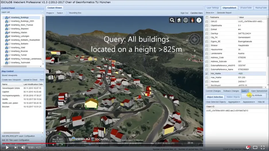
This demo contains all the generated thematic layers, such as buildings, streets, rivers, skiing lifts, power lines and much more. Additionally, each object is enriched with a variety of semantic information. This allows the visualisation of these data, as well as thematic queries and the interactive usage and evaluation of the semantic 3D landscape model.

Duration

2015

Project sponsor

Landesamt für Vermessung und Geoinformation Vorarlberg

Publications

2018

  • Fiutak, Georg; Marx, Caroline; Donaubauer, Andreas; Willkomm Philipp: Projekt 3D Digitales Landschaftsmodell (3D-DLM) am Runden Tisch GIS e.V. – Abschlussbericht (Demonstrationsphase): Datenvorverarbeitung, Anwendung des 3Dfiers, Abbildung auf CityGML-Datenmodell, Bereitstellung der Ergebnisdaten & Qualitätsbewertung. Runder Tisch GIS e.V., 2018, more… BibTeX
  • Fiutak, Georg; Marx, Caroline; Willkomm, Philipp; Donaubauer, Andreas; Kolbe, Thomas H.: Automatisierte Generierung eines digitalen Landschaftsmodells in 3D. PFGK18 - Photogrammetrie - Fernerkundung - Geoinformatik - Kartographie, 37. Jahrestagung in München 2018 (Publikationen der Deutschen Gesellschaft für Photogrammetrie, Fernerkundung und Geoinformation (DGPF) e.V. 27), Deutsche Gesellschaft für Photogrammetrie, Fernerkundung und Geoinformation e.V., 2018, 888-902 more… BibTeX

2017

  • Fiutak, Georg; Marx, Caroline; Donaubauer, Andreas; Willkomm Philipp: Projekt 3D Digitales Landschaftsmodell (3D-DLM) am Runden Tisch GIS e.V. – Abschlussbericht (Konzeptionsphase): Anwendungsszenarien, Datenevaluierung, Datenmodellierung & Methoden zur 2D -> 3D - Transformation. Runder Tisch GIS e.V., 2017, more… BibTeX
  • Marx, Caroline; Donaubauer, Andreas; Fiutak, Georg; Kolbe, Thomas H.: Digitales Landschaftsmodell in 3D. In: Kolbe, Thomas H.; Bill, Ralf; Donaubauer, Andreas (Ed.): Geoinformationssysteme 2017 – Beiträge zur 4. Münchner GI-Runde. Wichmann Verlag, 2017 more… BibTeX

2016

  • Donaubauer, Andreas; Esch, Roman; Kolbe, Thomas H.: Prozedurale Verfahren zur Generierung von 3D-Infrastrukturobjekten. In: Kolbe, Thomas H.; Bill, Ralf; Donaubauer, Andreas (Ed.): Geoinformationssysteme 2016. Wichmann, 2016 more… BibTeX
  • Esch, Roman: Prozedurale Generierung von 3D-Straßennetzwerken unter Berücksichtigung von Brücken und Tunneln am Beispiel Vorarlberg. Master thesis, 2016 more… BibTeX

2015

  • Kunde, Felix; Marx, Caroline; Donaubauer, Andreas: Projekt Semantisches 3D-Landschaftsmodell Vorarlberg (VoDLM3D) – Abschlussbericht (Demonstrationsphase): Vorstellung des Demonstrators für das geplante 3D-Stadt- und Landschaftsmodell Vorarlberg. Landesamt für Vermessung und Geoinformation (LVG) Vorarlberg, 2015, more… BibTeX