3D City Database


The award winning 3D City Database is a free 3D geo database to store, represent, and manage virtual 3D city models on top of a standard spatial relational database. The database model contains semantically rich, hierarchically structured, multi-scale urban objects facilitating complex GIS modeling and analysis tasks, far beyond visualization. The 3D City Database comes with additional software providing easy data exchange or facilitating coupling with cloud services. The 3D City Database content can be directly exported in KML, COLLADA, and glTF formats for the visualisation in a broad range of applications like Cesium WebGL Digital Globe, Google Earth, ArcGIS and ArcGIS Explorer. For further information see www.3dcitydb.org

Recent News

Virtual 3D Model of New York City in CityGML LOD1 available as Open Data

GISPro_3DCityDB, GISPro_CityGML |


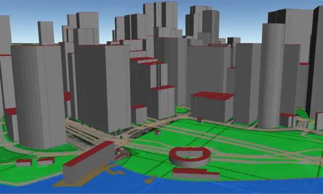
Our team at the Chair of Geoinformatics of Technische Universität München (TUM) has created and published a virtual 3D city model of New York City (NYC) that can freely be download from our project homepage. Also an Open Source 3D web viewer is provided allowing immediate interactive exploration and querying of the 3D model.

The city model is purely based on Open Data from the official Open Data Portal of NYC. 26 different datasets were integrated. From the 2D and 2.5D geospatial data around four million objects with 3D geometries were generated by a fully automated process. The resulting dataset covers the whole area from NYC and contains 3D buildings with addresses, streets, land lots, water bodies, parks, trees, and a triangulated digital terrain model. Most objects carry semantic information, because different thematic datasets from NYC administration were joined with the 3D model and their information was integrated. For example, most buildings carry information about the owner,  construction year, residential area, commercial area, office are (all in sqm) etc. The 3D model is provided as a CityGML dataset in Level of Detail 1 (LOD1). The total datasize is around 1.6 TB of XML data (around 80GB compressed). At this moment the building models (> 1 million), streets (150,000), and land parcels (> 860,000) only are ready for download (around 12 GB of XML data).

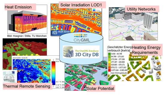
CityGML is an international standard of the Open Geospatial Consortium (OGC) for the representation and exchange of semantic 3D city models. It is employed by many countries, states, and cities worldwide. CityGML can represent semantic information, 3D geometry, 3D topology, and graphical appearances for the most relevant types of city objects. Due to this capability it is increasingly being used in projects on urban simulations, Smart Cities, disaster management, urban planning, and energy planning.

The data transformation and integration processes have been developed in the context of the two master theses of Mrs Barbara Burger and Mrs Berit Cantzler at TUM. The implementation is based on the Feature Manipulation Engine (FME) from Safe Software and our Open Source geodatabase 3DCityDB running on Oracle Spatial 12c. A paper summarizing the work and the results has just been presented at the Photogrammetric Week 2015 in Stuttgart, Germany. It can be downloaded together with the datasets from the project website (see below).

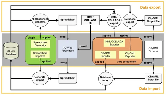
Using 3DCityDB, a tiled KML model was exported that can be interactively explored in our new Open Source 3D Webclient for 3DCityDB. The Webclient extends the Open Source software Cesium Virtual Globe by means to manage large tiled 3D models in KML, object highlighting etc. The viewer has been developed by Zhihang Yao and Kanishk Chaturvedi, both being PhD students at the Chair of Geoinformatics @ TUM.

Links:


Project description

Virtual 3D city models are complex mappings and inventories of the urban environment, which are being used in many different research and application fields like Smart Cities, urban planning, environmental and training simulations, disaster management, and energy assessment. The 3D City Database (3DCityDB) is an Open Source geodatabase schema and set of tools for managing and visualization of large 3D city models. It plays an important role in many research projects of the Chair of Geoinformatics. Above, it is employed in productive environments in many cities worldwide like Munich, Berlin, Zurich, Rotterdam, Helsinki, Singapore, London etc. Interfaces to different commercial 3D GIS software systems exist. The included tools provide full support of the OGC standard CityGML and allow for KML / COLLADA / glTF exports in order to create 3D visualizations for Digital Virtual Globes like the Cesium WebGL Digital Globe, Google Earth, and ArcGIS. By using the spreadsheet generator plugin the thematic data of CityGML objects in the geodatabase can also be extracted and mapped to simple tables.

The development of 3DCityDB was initiated and has been lead by Prof. Dr. Thomas H. Kolbe from the beginning. It started in 2003 at the Institute for Cartography and Geoinformation (IKG) of the University of Bonn and was continued from 2006 at the Institute for Geodesy and Geoinformation Science (IGG) of Berlin University of Technology. Since 2012 the 3DCityDB and its tools are further developed by the Chair of Geoinformatics of TU Munich (TUMGI) in collaboration with the companies virtualcitySYSTEMS GmbH and M.O.S.S. Computer Grafik Systeme GmbH on the basis of a cooperation agreement. This agreement ensures that not only the involved parties but also the international user community benefit from all improvements and new features. With the release of 3DCityDB version 3.3 the Open Source license was switched from LGPL3 to Apache 2.0 simplifying the inclusion and adoption of 3DCityDB in third party products. Aim of the free provision of the 3DCityDB is last but not least the advancement of the adoption of the CityGML standard, which is an essential research topic at the Chair of Geoinformatics.

We use 3DCityDB also in teaching and student projects. Students learn about 3D city modeling, about mapping of complex object oriented data models to spatio-relational database schemas, spatial databases in general, and 3D geovisualization. These aspects are addressed and explained in detail in the extensive and complete documentation coming with the 3DCityDB. The documentation as well as a number of online courses can be found on the 3DCityDB homepage.

Learning materials

The extensive documentation of the 3DCityDB explains the underlying mapping of the CityGML data model onto the relational schema with spatial data types, the diverse software tools (importer/exporter, 3D webclient) and their usage.

The two staff members and researchers Zhihang Yao and Kanishk Chaturvedi have created a tutorial with an  introduction to the current version 3.3 of the 3DCityDB. The tutorial consists of two comprehensive presentations on 1) the browser-based 3D geovisualization and 2) on working with CityGML and 3DCityDB. Furthermore, they have created a hands-on tutorial explaining step by step the download and installation of the software, the import of CityGML datasets, the export and 3D visualization of city models in a web browser. These course materials are provided here under the Creative Commons License CC BY-NC-SA 3.0:

On September 27-28, 2016, Kanishk Chaturvedi and Zhihang Yao followed the invitation of Prof. Jantien Stoter, head of the 3D Geoinformation Group at TU Delft, and held a two-days course on the 3DCityDB and the browser-based 3D geovisualization in the 3DViz 2016 workshop at TU Delft. Their presentations were recorded and can be viewed from the workshop website.

Docker Images

The individual components of the 3DCityDB are also available as images for the Docker virtualization technology. This makes it possible to install and configure a 3DCityDB with a single command line statement in almost any runtime environment.

What is Docker?

Docker is a widely used virtualization technology that makes it possible to pack an application with all its required resources into a standardized unit - the Docker Container. Software encapsulated in this way can run on Linux, Windows, macOS and most cloud services without any further changes. Docker containers are lightweight compared to traditional virtualization environments that emulate an entire operating system because they contain only the application and all the tools, program libraries, and files it requires.

Getting started

The Docker Container for 3DCityDB is based on the Open Source database management system PostgreSQL and the PostGIS extension for spatial data. The image is freely available via DockerHub and can now be downloaded and used. Detailed documentation and source code can be found on the GitHub project page. All that is needed is a Docker Installation on your system. The time-consuming installation of a database server, its configuration, the installation of a database extension for spatial data and the setup of the 3DCityDB data model are a thing of the past.

Further images

In addition to the Docker Image for 3DCityDB, Docker Images for the 3DCityDB Web-Feature-Service (WFS) and the 3DCityDB 3D-Web-Map-Client are also available.

Docker Compose files are available for orchestrating the individual services. This allows for example, that a single command call can be used to create a 3DCityDB linked to a 3DCityDB WFS, which makes the data from the database accessible via a standardized web interface.

Documentation and downloads

Image Documentation, source code Image download Build status
3DCityDB GitHub DockerHub Travis CI
3DCityDB WFS GitHub DockerHub Travis CI
3DCityDB Web Map GitHub DockerHub  
Compose GitHub    


Contact person

M.Sc. Son H. Nguyen


Project leader

Prof. Thomas H. Kolbe


Publications

2024

  • Kolbe, Thomas H.; Donaubauer, Andreas; Beil, Christof (Ed.): Recent Advances in 3D Geoinformation Science – Proceedings of the 18th 3D GeoInfo Conference. Lecture Notes in Geoinformation and Cartography. Springer, 2024 more… BibTeX
  • Olbrich, Felix; Beil, Christof; Nguyen, Son H.; Kolbe, Thomas H.: Multimodale Navigationsanwendungen für CityGML 3.0-konforme 3D-Straßenraummodelle mittels Graphdatenbanken. 44. Wissenschaftlich-Technische Jahrestagung der DGPF in Remagen – Publikationen der DGPF, Deutsche Gesellschaft für Photogrammetrie, Fernerkundung und Geoinformation e.V., 2024, 357-369 more… BibTeX

2023

  • Beil, Christof; Ilic, Mario; Keler, Andreas; Kolbe, Thomas H.: Automatically evaluating the service quality of bicycle paths based on semantic 3D city models. Lecture Notes in Geoinformation and Cartography - Recent Advances in 3D Geoinformation Science - Proceedings of the 18th 3D GeoInfo Conference, 2023 more… BibTeX
  • Gitahi, Joseph; Kolbe, Thomas H.: Requirements for Web-based 4D Visualisation of Integrated 3D City Models and Sensor Data in Urban Digital Twins. Lecture Notes in Geoinformation and Cartography - Recent Advances in 3D Geoinformation Science - Proceedings of the 18th 3D GeoInfo Conference, 2023 more… BibTeX
  • Olbrich, Felix S.: Multimodal Navigation Applications for CityGML 3.0 using a Graph Database. Master thesis, 2023 more… BibTeX

2022

  • Beil, Christof; Kendir, Murat; Ruhdorfer, Roland; Kolbe, Thomas H.: Dynamic and web-based 4D visualization of streetspace activities derived from traffic simulations and semantic 3D city models. Proceedings of the 17th International 3D GeoInfo Conference 2022 , 2022 more… BibTeX
  • Apra, Irène: Semantic segmentation of roof superstructures. Master thesis, 2022 more… BibTeX
  • Faltermeier, Florian: Improving CNN roof segment detection by dataset extension using 3D city models. Projekt thesis, 2022 more… BibTeX
  • Knoll, Kevin: Zusammenführung von Luftbild- und 3D-basierter Photovoltaik-Potenzialanalyse. Master thesis, 2022 more… BibTeX
  • Krapf, Sebastian; Willenborg, Bruno; Knoll, Kevin; Bruhse, Matthias; Kolbe, Thomas H.: Deep Learning for Semantic 3D City Model Extension: Modeling Roof Superstructures using Aerial Images for Solar Potential Analysis. ISPRS Annals of the Photogrammetry, Remote Sensing and Spatial Information Sciences (ISPRS Annals of the Photogrammetry, Remote Sensing and Spatial Information Sciences), 2022 more… BibTeX
  • Meyer, Markus: Interactive Retrieval and Exploration of Information Resources by Coupling of a 3D Web Viewer and a Smart City Catalog Service. Master thesis, 2022 more… BibTeX

2021

  • Beil, Christof; Kutzner, Tatjana; Schwab, Benedikt; Willenborg, Bruno; Gawronski, Alexander; Kolbe, Thomas H.: Integration of 3D point clouds with semantic 3D city models – Providing semantic information beyond classification. Proceedings of the 16th International 3D GeoInfo Conference 2021 ( ISPRS Annals of the Photogrammetry, Remote Sensing and Spatial Information Sciences ), 2021, 105--112 more… BibTeX
  • Krauth, T.: Kopplung von Simulationssoftware mit Semantischen 3DStadtmodellen für Urbane Mikroklimasimulation. Master thesis, 2021 more… BibTeX
  • Sedlmeier, P.: Extending the Calibration of the Transition Model for Calculating Solar Radiation Values. IDP-Arbeit, 2021 more… BibTeX

2020

  • Beil, Christof; Kolbe, Thomas H.: Combined modelling of multiple transportation infrastructure within 3D city models and its implementation in CityGML 3.0. Proceedings of the 15th International 3D GeoInfo Conference 2020 ( ISPRS Annals of the Photogrammetry, Remote Sensing and Spatial Information Sciences ), ISPRS , 2020 more… BibTeX
  • Beil, Christof; Ruhdorfer, Roland; Coduro, Theresa; Kolbe, Thomas H.: Detailed Streetspace Modelling for Multiple Applications: Discussions on the Proposed CityGML 3.0 Transportation Model. ISPRS International Journal of Geo-Information 9 (10), 2020, 603 more… BibTeX
  • Besinger, Leander: Solarpotentialanalyse auf Basis von 3D-Stadtmodellen – Performance und Ergebnisqualität. Bachelor thesis, 2020 more… BibTeX
  • Harter, H.; Willenborg, B.; Lang, W.; Kolbe, T. H.: Life Cycle Assessment of Technical Building Services of Large Residential Building Stocks using Semantic 3D City Models. ISPRS Annals of Photogrammetry, Remote Sensing and Spatial Information Sciences VI-4/W1-2020, 2020, 85-92 more… BibTeX
  • Hijazi, Ihab H.; Krauth, Tobias; Donaubauer, Andreas; Kolbe, Thomas H.: 3DCityDB4BIM: A System Architecture for Linking BIM Server and 3DCityDB for BIM-GIS-Integration. Proceedings of the XXIV ISPRS Congress (ISPRS Annals of Photogrammetry, Remote Sensing and Spatial Information Sciences), Copernicus GmbH, 2020, 195-202 more… BibTeX

2019

  • Bolduan, Tobias: A new approach for integrating BIM and GIS based on Model View Definition and Profiling Geospatial Application Schemas. Master thesis, 2019 more… BibTeX

2018

  • Chaturvedi, Kanishk; Matheus, Andreas; Nguyen, Son H.; Kolbe, Thomas H.: Securing Spatial Data Infrastructures in the Context of Smart Cities. 2018 International Conference on CYBERWORLDS (CW 2018), 2018, 403-408 more… BibTeX
  • Nguyen, Son H.; Yao, Zhihang; Kolbe, Thomas H.: Spatio-Semantic Comparison of Large 3D City Models in CityGML Using a Graph Database. gis.Science (3/2018), 2018, 85-100 more… BibTeX
  • Yao, Zhihang; Kolbe, Thomas H.: A new Approach to Model Transformation using Graph Transformation System. PFGK18 - Photogrammetrie - Fernerkundung - Geoinformatik - Kartographie, 37. Jahrestagung in München 2018 (Publikationen der Deutschen Gesellschaft für Photogrammetrie, Fernerkundung und Geoinformation (DGPF) e.V. 27), Deutsche Gesellschaft für Photogrammetrie, Fernerkundung und Geoinformation e.V., 2018, 831-834 more… BibTeX
  • Yao, Zhihang; Nagel, Claus; Kunde, Felix; Hudra, György; Willkomm, Philipp; Donaubauer, Andreas; Adolphi, Thomas; Kolbe, Thomas H.: 3DCityDB - a 3D geodatabase solution for the management, analysis, and visualization of semantic 3D city models based on CityGML. Open Geospatial Data, Software and Standards 3 (5), 2018, 1-26 more… BibTeX

2017

  • Moshrefzadeh, Mandana; Chaturvedi, Kanishk; Hijazi, Ihab; Donaubauer, Andreas; Kolbe, Thomas H.: Integrating and Managing the Information for Smart Sustainable Districts - The Smart District Data Infrastructure (SDDI). In: Kolbe, Thomas H.; Bill, Ralf; Donaubauer, Andreas (Ed.): Geoinformationssysteme 2017 – Beiträge zur 4. Münchner GI-Runde. . Wichmann Verlag , 2017 more… BibTeX
  • Baghdoust, Amir: Visualizing dynamic spatial height information in a dam monitoring context. Master thesis, 2017 more… BibTeX
  • Beil, Christof: Detaillierte Repräsentation des Straßenraums in 3D-Stadtmodellen. Master thesis, 2017 more… BibTeX
  • Beil, Christof; Kolbe, Thomas H.: CityGML and the streets of New York - A proposal for detailed street space modelling. Proceedings of the 12th International 3D GeoInfo Conference 2017 (ISPRS Annals of the Photogrammetry, Remote Sensing and Spatial Information Sciences), ISPRS, 2017, 9-16 more… BibTeX
  • Deigele, Wolfgang: Effizientes Management und 3D-Visualisierung von großen DGM in einem räumlichen Datenbanksystem. Bachelor thesis, 2017 more… BibTeX
  • Egger, Franziska: 3D-Stadtmodelle nach CityGML-Standard als Planungsinstrument für BIM-Infrastrukturprojekte am Beispiel der U4-Netzerweiterung auf die Horner Geest in Hamburg. Studien thesis, 2017 more… BibTeX
  • Kluger, Niklas: Erweiterung eines Open Source 3D-Webclients zur interaktiven Darstellung von zeitabhängigen Gebäudetexturen. Bachelor thesis, 2017 more… BibTeX
  • Nguyen, Son H.: Spatio-semantic Comparison of 3D City Models in CityGML using a Graph Database. Master thesis, 2017 more… BibTeX
  • Ruhdorfer, Roland: Kopplung von Verkehrssimulation und semantischen 3D-Stadtmodellen in CityGML. Master thesis, 2017 more… BibTeX
  • Yao, Zhihang; Kolbe, Thomas H.: Dynamically Extending Spatial Databases to support CityGML Application Domain Extensions using Graph Transformations. Kulturelles Erbe erfassen und bewahren - Von der Dokumentation zum virtuellen Rundgang, 37. Wissenschaftlich-Technische Jahrestagung der DGPF (Publikationen der Deutschen Gesellschaft für Photogrammetrie, Fernerkundung und Geoinformation (DGPF) e.V.), Deutsche Gesellschaft für Photogrammetrie, Fernerkundung und Geoinformation e.V., 2017, 316-331 more… BibTeX

2016

  • Hotschek, Alexander: Nutzung von Smartphone-Sensoren zur Navigation in der Kartenansicht eines 3D-Webclients. Bachelor thesis, 2016 more… BibTeX
  • Kausika, Bhavya; Moshrefzadeh, Mandana; Kolbe, Thomas H.; van Sark, Wilfried: 3D Solar Potential Modelling and Analysis: A case study for the city of Utrecht. 32nd European Photovoltaic Solar Energy Conference and Exhibition, EUPVSEC 2016, 2016 more… BibTeX
  • Moshrefzadeh, Mandana; Kolbe, Thomas H.: Smart Data Infrastructure for Smart and Sustainable Cities. 13th International Conference on Design & Decision Support Systems in Architecture and Urban Planning , 2016DDSS 2016 more… BibTeX
  • Willenborg, Bruno; Sindram, Maximilian; Kolbe, Thomas H.: Semantic 3D City Models Serving as Information Hub for 3D Field Based Simulations. Lösungen für eine Welt im Wandel, 3-Ländertagung der SGPF, DGPF und OVG in Bern, 2016Dreiländertagung der DGPF, der OVG und der SGPF more… BibTeX
  • Yao, Zhihang; Chaturvedi, Kanishk; Kolbe, Thomas H.: Browser-basierte Visualisierung großer 3D-Stadtmodelle durch Erweiterung des Cesium Web Globe. Geoinformationssysteme 2016 - Beiträge zur 3. Münchner GI-Runde, Wichmann Verlag, 2016, 77-89 more… BibTeX

2015

  • Burger, Barbara: Erzeugung eines semantischen 3D-Stadtmodells der Stadt New York auf der Basis von Open Data - DGM, Straßen und Zonierung. Master thesis, 2015 more… BibTeX
  • Cantzler, Berit: Erzeugung eines semantischen 3D-Stadtmodells der Stadt New York auf der Basis von Open Data - DGM, Gebäude, Flurstücke, Gewässer, Parks und Bäume. Master thesis, 2015 more… BibTeX
  • Chaturvedi, Kanishk; Yao, Zhihang; Kolbe, Thomas H.: Web-based Exploration of and Interaction with Large and Deeply Structured Semantic 3D City Models using HTML5 and WebGL. Bridging Scales - Skalenübergreifende Nah- und Fernerkundungsmethoden, 35. Wissenschaftlich-Technische Jahrestagung der DGPF, Deutsche Gesellschaft für Photogrammetrie, Fernerkundung und Geoinformation e.V., 2015 more… BibTeX
  • Willenborg, Bruno: Simulation of Explosions in Urban Space and Result Analysis Based on CityGML City Models and a Cloud Based 3D Web Client. Master thesis, 2015 more… BibTeX
  • Zahn, Wolfgang: Sonneneinstrahlungsanalyse auf und Informationsanreicherung von großen 3D-Stadtmodellen im CityGML-Schema. Master thesis, 2015 more… BibTeX

2014

  • Yao, Zhihang; Kolbe, Thomas H.: Cloud-basierter Webclient für kollaboratives Arbeiten auf semantischen 3D-Stadtmodellen. Geoinformationen öffnen das Tor zur Welt, 34. Wissenschaftlich-Technische Jahrestagung der DGPF (Publikationen der Deutschen Gesellschaft für Photogrammetrie, Fernerkundung, Geoinformation e.V.), Deutsche Gesellschaft für Photogrammetrie, Fernerkundung, Geoinformation e.V., 2014 more… BibTeX
  • Yao, Zhihang; Sindram, Maximilian; Kaden, Robert; Kolbe, Thomas H.: Cloud-basierter 3D-Webclient zur kollaborativen Planung energetischer Maßnahmen am Beispiel von Berlin und London. In: Kolbe, Thomas H.; Bill, Ralf; Donaubauer, Andreas (Ed.): Geoinformationssysteme 2014. Wichmann, 2014 more… BibTeX

2013

  • Kaden, Robert; Nagel, Claus; Herreruela, Javier; Kolbe, Thomas H.: Kopplung von 3D-Stadtmodellen mit Cloud-Diensten. Neue Horizonte für Geodateninfrastrukturen – Open GeoData, Mobility, 3D-Stadt, 2013 more… BibTeX
  • Kunde, F.; Nagel, Claus; Herrerruela, Javier; Ross, L.; Kolbe, Thomas H.: 3D-Stadtmodelle in PostGIS mit der 3D City Database. Tagungsband der FOSSGIS-Konferenz, 2013 more… BibTeX

2012

  • Herreruela, Javier; Nagel, Claus; Kolbe, Thomas H.: Value-added Services for 3D City Models using Cloud Computing. Geoinformatik 2012 "Mobilität und Umwelt", Konferenzband zur Tagung Geoinformatik 2012 vom 28.-30.3.2012 in Braunschweig (Berichte aus der Geoinformatik), Shaker, 2012 more… BibTeX

2010

  • Carrión, Daniel; Lorenz, Alexandra; Kolbe, Thomas H.: Estimation of the energetic rehabilitation state of buildings for the city of Berlin using a 3D city model represented in CityGML. ISPRS Conference: International Conference on 3D Geoinformation. XXXVIII-4, ISPRS, 2010 more… BibTeX

2009

  • Stadler, Alexandra; Nagel, Claus; König, Gerhard; Kolbe, Thomas H.: Making interoperability persistent : A 3D geo database based on CityGML – 11. In: Lee, Jiyeong; Zlatanova, Sisi (Ed.): 3D Geo-Information Sciences. Springer, 2009, 175-192 more… BibTeX

2005

  • Gröger, Gerhard; Kolbe, Thomas H.; Schmittwilken, Jörg; Stroh, Viktor; Plümer, Lutz: Integrating Versions, History, and Levels-of-Detail within a 3D Geodatabase. International Workshop on Next Generation 3D City Models (EuroSDR Publications 49), European Spatial Data Research (EuroSDR), 2005, 35-40 more… BibTeX