CityGML is an international standard issued by the Open Geospatial Consortium (OGC) on the modeling, storage, and exchange of semantic 3D city models. Version 2.0 of the standard was adopted by the OGC in March 2012. The Chair of Geoinformatics is actively involved in the development of version 3.0 and coordinates the creation of the specification documents, the data models, and the GML application schemas.
Version 3.0 of the CityGML standard consists of several parts. The first part of the standard, Version 3.0.0 - Part 1: Conceptual Model Standard, was adopted by the OGC in September 2021. The second part on the GML Encoding is planned for publication by the end of 2022.
Project description
In order to increase the usability of CityGML for more user groups and areas of application, the OGC CityGML Standards Working Group (SWG) and the Special Interest Group 3D (SIG 3D) of the initiative Geodata Infrastructure Germany (GDI-DE) work since 2014 on the further development of CityGML.
This development results in the new major version CityGML 3.0 which is to be finalised by the end of 2022. The new version brings a number of improvements, extensions, and new functionalities.
Use of a model-driven approach: The data model is now fully based on the ISO 191xx standards. The software tool Enterprise Architect is used for creating the data model and the GML encoding will be fully automatically derived from the data model using the software tool ShapeChange.
Revised LOD concept: LOD4 has been removed, the interior of objects can be expressed in different LODs 0-3 now. It is e.g. possible to model the outside shell of a building in LOD1 while representing the interior structure in LOD2 or 3.
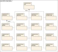
New and revised modules: CitygML 3.0 includes several new and revised modules which allow for better use of 3D city models in different areas of application such as urban planning, energy simulations, and traffic analyses, reduce redundancy by integrating and providing concepts used in several modules centrally via inheritance, simplify geometry handling, and improve the representation of physical and logical objects.
New Core model: All spatial representations base on the two new pivotal concepts Space and SpaceBoundary. The geometry can now also be given by point clouds. The new core model implements the new LOD concept.
New Construction module: Groups all classes which are similar over different types of constructions like buildings, tunnels, and bridges. Allows for representing constructions not being covered by any of the other modules.
New Versioning module: Allows to explicitly represent and exchange multiple versions of city objects (e.g. history or alternative designs) within one city model dataset. All objects can have bitemporal lifespan data.
New Dynamizer module: Defines concepts to represent and exchange time-varying data for city object properties (e.g. solar irradiation over the day) as well as to integrate sensors with 3D city models. Data sources can be timeseries data represented inline, in external files, or from sensor web services (OGC Sensor Web Enablement or Internet of Things, IoT, in general).
Revised Transportation module: Transportation objects like Roads, Tracks, or Railways can now be subdivided into sections and have an area as well as a center line representation for each LOD.
Revised Building module: Allows now for representing storeys and building units.
Improved interoperability with other standards: CityGML 3.0 allows for better interoperability with other relevant standards like IndoorGML, Industry Foundation Classes (IFC), Land Administration Domain Model (LADM), as well as with Semantic Web Technologies like Resource Description Framework (RDF) and with the EU Directive INSPIRE (Infrastructure for spatial information in Europe).
Backwards compatibility: All modifications to the new CityGML 3.0 model are carried out in a way to ensure backwards compatibility with CityGML 1.0 and 2.0
The CityGML 3.0 standard consists of at least two parts:
The specification "CityGML 3.0 Part 1: Conceptual Model Standard"
The specification "CityGML 3.0 Part 2: GML Encoding Standard"
Further encoding specifications (e.g. relational database schema, JSON-based representation) which may follow in the future
GML application schemata have been derived from the UML model using the software ShapeChange. The current draft of the GML application schemata can be downloaded from this github repository: https://github.com/opengeospatial/CityGML-3.0Encodings (Folder "CityGML")
Test data sets
Test data sets that are compliant to the CityGML 3.0 standard are available here:
New Webinars on New Features in CityGML 3.0 and its Graph-based Applications (CUT Academy)
GISPro_CityGML
|
In October, two new CUT Academy videos on CityGML 3.0, its functions and application showcases have been published!
CityGML 3.0 and its new features
CityGML and its graph-based applications
Son H. Nguyen and Felix Olbrich from the Chair of Geoinformatics have contributed two new webinars to the CUT Academy in October 2024, which focus on the new features in CityGML 3.0 and its graph-based applications. In the “Connected Urban Twins” (CUT) project, Urban Digital Twins (UDT) are being jointly developed for integrated urban development. The CUT Academy serves as a platform for the exchange and discussion of knowledge - both between the partners of the CUT project and with the public, for example through webinars.
CityGML 3.0 is an official international OGC standard since 2023. This video summarizes the most important new features of the new version.
A brief overview:
New and revised modules: In addition to revised modules such as CityGML Core, Generics, Building and Transportation, CityGML 3.0 also has new modules such as Dynamizer, Versioning, PointCloud and Construction.
New concepts for spaces and space boundaries: All city objects are now based on the concept of Space and SpaceBoundary; all geometries are bound to it.
Interior modelling without LOD4: CityGML 3.0 enables interior modeling in any LOD. This eliminates the need for LOD4.
Modelling of changes: Fast, dynamic changes are handled by the Dynamizer module, while slow changes are handled by the Versioning module.
Improved representation of transportation infrastructure: CityGML 3.0 allows for a detailed representation of street space as part of a standardized and consistent semantic 3D city model.
City objects, especially those encoded in CityGML, are structured like graphs. This video presents two applications that use graph representations of CityGML datasets: (1) Identification and interpretation of changes to a city, and (2) Multimodal navigation using detailed street space modelling of a city.
A brief overview:
Graph structure of CityGML: CityGML objects are structured like graphs. Graph-based methods and algorithms can therefore be applied.
The Neo4j graph database: In the applications presented, graph representations of city objects are stored in the Neo4j graph database. Neo4j is currently one of the most popular graph databases worldwide.
Identification and interpretation of changes: Graphs can be used to compare CityGML datasets with each other to detect changes. These changes are then interpreted to identify meaningful patterns for specific stakeholders.
Multimodal navigation: Graph representations of street spaces in CityGML 3.0 can also be used to enable multimodal navigation.
Interactive Neo4j tutorials: This video is accompanied by interactive tutorials for Neo4j and its query language Cypher.
Further resources:
GitHub repository for identification and interpretation of changes in CityGML graphs
GitHub repository for the construction of knowledge graphs from semantic 3D city models
Endo Barbosa, Julia: Modeling Residential Energy Load Profiles with Semantic 3DCity Models and Machine Learning. Bachelor thesis, 2025 more…BibTeX
González-Collazo, Silvia María; Schwab, Benedikt; Beil, Christof; Kolbe, Thomas H.; González, Elena; Balado, Jesús: Curbside management from MLS and HMLS point clouds to CityGML 3.0. Geo-spatial Information Science, 2025, 1-23 more…BibTeX
Jha, Madhulika: Optimizing PV Placement on buildings using solar irradiation data and CityGML 3D Models: A Multi‐Criteria Analysis Approach. Master thesis, 2025 more…BibTeX
Kanna, Khaoula; Kolbe, Thomas H.: Advanced User Interaction with Urban Digital Twins using Large Language Models. ISPRS Geospatial Week (GSW) 2025, 2025 more…BibTeX
2024
Kolbe, Thomas H.; Donaubauer, Andreas; Beil, Christof (Ed.): Recent Advances in 3D Geoinformation Science – Proceedings of the 18th 3D GeoInfo Conference. Lecture Notes in Geoinformation and Cartography. Springer, 2024 more…BibTeX
Bachert, Carolin; León-Sánchez, Camilo; Kutzner, Tatjana; Agugiaro, Giorgio: Mapping the CityGML Energy ADE to CityGML 3.0 Using a Model-Driven Approach. ISPRS International Journal of Geo-Information 13 (4), 2024, 121 more…BibTeX
Beil, Christof; Kolbe, Thomas H.: Applications for Semantic 3D Streetspace Models and their Requirements - A Review and Look at the Road Ahead. ISPRS International Journal of Geo-Information 13 (10), 2024, 363 more…BibTeX
Beltran Sanchez, Armando Isaac: Using Semantic 3D City Models as the Single Data Source for Urban Microclimate Simulations. Bachelor thesis, 2024 more…BibTeX
Olbrich, Felix; Beil, Christof; Nguyen, Son H.; Kolbe, Thomas H.: Multimodale Navigationsanwendungen für CityGML 3.0-konforme 3D-Straßenraummodelle mittels Graphdatenbanken. 44. Wissenschaftlich-Technische Jahrestagung der DGPF in Remagen – Publikationen der DGPF, Deutsche Gesellschaft für Photogrammetrie, Fernerkundung und Geoinformation e.V., 2024, 357-369 more…BibTeX
Quarg, Julia: Expandable Urban Knowledge Graphs: A Use Case in CityGML with OpenStreetMap Data. Bachelor thesis, 2024 more…BibTeX
Sändig, Sebastian: Repräsentation von Baugrundaufschlüssen in 3D-Geoinformationssystemen am Beispiel der Deutschen Bahn. Bachelor thesis, 2024 more…BibTeX
Wang, Hanbin; Hijazi, Ihab; Donaubauer, Andreas; Kolbe, Thomas H.: Optimizing Urban Layout: A System Dynamics, Artificial Intelligence, and 3D Urban Information Model Approach for Active Management of City Complexity. Proceedings of the 19th International 3D GeoInfo Conference 2024 (ISPRS Annals of the Photogrammetry, Remote Sensing and Spatial Information Sciences), Copernicus GmbH, 2024, 317-324 more…BibTeX
Wysocki, Olaf; Schwab, Benedikt; Beil, Christof; Holst, Christoph; Kolbe, Thomas H.: Reviewing Open Data Semantic 3D City Models to Develop Novel 3D Reconstruction Methods. ISPRS TC IV Mid-term Symposium “Spatial Information to Empower the Metaverse” (The International Archives of the Photogrammetry, Remote Sensing and Spatial Information Sciences), ISPRS, 2024, 493–500 more…BibTeX
2023
Bachert, Carolin: Mapping the Energy ADE to CityGML 3.0. Master thesis, 2023 more…BibTeX
Bajramovic, Vedran: Development of an Automated Transformation Method of GB Road Network Data for Connected and Automated Mobility Applications. Master thesis, 2023 more…BibTeX
Beil, Christof; Ilic, Mario; Keler, Andreas; Kolbe, Thomas H.: Automatically evaluating the service quality of bicycle paths based on semantic 3D city models. Lecture Notes in Geoinformation and Cartography - Recent Advances in 3D Geoinformation Science - Proceedings of the 18th 3D GeoInfo Conference, 2023 more…BibTeX
Faltermeier, Florian L.; Krapf, Sebastian; Willenborg, Bruno; Kolbe, Thomas H.: Improving Semantic Segmentation of Roof Segments Using Large-Scale Datasets Derived from 3D City Models and High-Resolution Aerial Imagery. Remote Sensing 15 (17), 2023 more…BibTeX
Gitahi, Joseph; Kolbe, Thomas H.: Requirements for Web-based 4D Visualisation of Integrated 3D City Models and Sensor Data in Urban Digital Twins. Lecture Notes in Geoinformation and Cartography - Recent Advances in 3D Geoinformation Science - Proceedings of the 18th 3D GeoInfo Conference, 2023 more…BibTeX
Hamza Zahid: Integrating Regulatory Compliance into Urban Simulations: A Framework based on CityGML and XPlanung. Master thesis, 2023 more…BibTeX
Kutzner, Tatjana; Smyth, Carl; Nagel, Claus; Coors, Volker; Vinasco-Alvarez, Diego; Ishimaru, Nobuhiro; Yao, Zhihang; Heazel, Charles; Kolbe, Thomas H: OGC City Geography Markup Language (CityGML) Version 3.0 Part 2: GML Encoding Standard – International Standard, OGC Document No. 21-006r2. Open Geospatial Consortium, 2023 more…BibTeX
Nguyen, Son H.; Kolbe, Thomas H.: Identification and Interpretation of Change Patterns in Semantic 3D City Models. Lecture Notes in Geoinformation and Cartography - Recent Advances in 3D Geoinformation Science - Proceedings of the 18th 3D GeoInfo Conference, Springer, 2023 more…BibTeX
Olbrich, Felix S.: Multimodal Navigation Applications for CityGML 3.0 using a Graph Database. Master thesis, 2023 more…BibTeX
2022
Beil, Christof; Kendir, Murat; Ruhdorfer, Roland; Kolbe, Thomas H.: Dynamic and web-based 4D visualization of streetspace activities derived from traffic simulations and semantic 3D city models. Proceedings of the 17th International 3D GeoInfo Conference 2022 , 2022 more…BibTeX
Faltermeier, Florian: Improving CNN roof segment detection by dataset extension using 3D city models. Projekt thesis, 2022 more…BibTeX
Hijazi, Ihab; Donaubauer, Andreas; Hamm, Annika; Falkenstein, Antonia; Kolbe, Thomas H.: Urban Growth Simulation using Urban Dynamics and CityGML: A Use Case from the City of Munich. Proceedings of the 17th International 3D GeoInfo Conference 2022 (ISPRS Annals of the Photogrammetry, Remote Sensing and Spatial Information Sciences), 2022 more…BibTeX
Knoll, Kevin: Zusammenführung von Luftbild- und 3D-basierter Photovoltaik-Potenzialanalyse. Master thesis, 2022 more…BibTeX
Nguyen, Son H.; Kolbe, Thomas H.: Path-tracing Semantic Networks to Interpret Changes in Semantic 3D City Models. Proceedings of the 17th International 3D GeoInfo Conference 2022 (ISPRS Annals of the Photogrammetry, Remote Sensing and Spatial Information Sciences), ISPRS, 2022 more…BibTeX
Schwab, Benedikt; Kolbe, Thomas H.: Validation of Parametric OpenDRIVE Road Space Models. Proceedings of the 17th International 3D GeoInfo Conference 2022 (ISPRS Annals of the Photogrammetry, Remote Sensing and Spatial Information Sciences), 2022 more…BibTeX
2021
Beil, Christof; Kutzner, Tatjana; Schwab, Benedikt; Willenborg, Bruno; Gawronski, Alexander; Kolbe, Thomas H.: Integration of 3D point clouds with semantic 3D city models – Providing semantic information beyond classification. Proceedings of the 16th International 3D GeoInfo Conference 2021 ( ISPRS Annals of the Photogrammetry, Remote Sensing and Spatial Information Sciences ), 2021, 105--112 more…BibTeX
Beck, Stefan F.; Abualdenien, Jimmy; Hijazi, Ihab H.; Borrmann, André; Kolbe, Thomas H.: Analyzing Contextual Linking of Heterogeneous Information Models from the Domains BIM and UIM. ISPRS International Journal of Geo-Information 10 (12), 2021, 807 more…BibTeX
Gawronski, Alexander: Identifikation von geometrischen Abweichungen zwischen semantischen Stadtmodellen und Punktwolken. Bachelor thesis, 2021 more…BibTeX
Kolbe, Thomas H.; Donaubauer, Andreas: Semantic 3D City Modeling and BIM. In: Shi, Wenzhong; Goodchild, Michael F.; Batty, Michael; Kwan, Mei-Po; Zhang, A. (Ed.): Urban Informatics. Springer, 2021 more…BibTeX
Kolbe, Thomas H.; Kutzner, Tatjana; Smyth, Carl Steven; Nagel, Claus; Roensdorf, Carsten; Heazel, Charles: OGC City Geography Markup Language (CityGML) Version 3.0 Part 1: Conceptual Model Standard – International Standard, OGC Document No. 20-010. Open Geospatial Consortium, 2021 more…BibTeX
Krauth, T.: Kopplung von Simulationssoftware mit Semantischen 3DStadtmodellen für Urbane Mikroklimasimulation. Master thesis, 2021 more…BibTeX
Kutzner, Tatjana; Donaubauer, Andreas: CityGML 3.0 – Neue Konzepte und Perspektiven für einen Digitalen Lageplan in 3D. Geoinformationssysteme 2021 - Beiträge zur 8. Münchner GI-Runde, 2021, 55-57 more…BibTeX
Nguyen, Son H.; Kolbe, Thomas H.: Modelling Changes, Stakeholders and their Relations in Semantic 3D City Models. Proceedings of the 16th International 3D GeoInfo Conference 2021 (ISPRS Annals of the Photogrammetry, Remote Sensing and Spatial Information Sciences), ISPRS, 2021, 137-144 more…BibTeX
Sedlmeier, P.: Extending the Calibration of the Transition Model for Calculating Solar Radiation Values. IDP-Arbeit, 2021 more…BibTeX
Wilhelm, Laura; Donaubauer, Andreas; Kolbe, Thomas H.: Integration of BIM and Environmental Planning: The CityGML EnvPlan ADE. Journal of Digital Landscape Architecture (6-2021), 2021 more…BibTeX
Wysocki, Olaf.; Schwab, Benedikt.; Hoegner, Ludwig.; Kolbe, Thomas H.; Stilla, Uwe: Plastic Surgery for 3D City Models: A Pipeline for Automatic Geometry Refinement and Semantic Enrichment. ISPRS Annals of the Photogrammetry, Remote Sensing and Spatial Information Sciences, Copernicus GmbH, 2021ISPRS Congress 2021, 17-24 more…BibTeX
2020
Akahoshi, Kentaro; Ishimaru, Nobuhiro; Kurokawa, Chikako; Tanaka, Yuichi; Oishi, Tomohisa; Kutzner, Tatjana; Kolbe, Thomas H.: i-Urban Revitalization: Conceptual Modeling, Implementation, and Visualization Towards Sustainable Urban Planning Using CityGML. Proceedings of the XXIV ISPRS Congress (ISPRS Annals of Photogrammetry, Remote Sensing and Spatial Information Sciences), Copernicus GmbH, 2020, 179-186 more…BibTeX
Beck, Fritz; Borrmann, André; Kolbe, Thomas H.: The need for a differentiation between heterogeneous information integration approaches in the field of “BIM-GIS Integration”: a literature review. Proceedings of the 3rd International BIM GIS Integration Workshop (ISPRS Annals of the Photogrammetry, Remote Sensing and Spatial Information Sciences), 2020 more…BibTeX
Beil, Christof; Kolbe, Thomas H.: Combined modelling of multiple transportation infrastructure within 3D city models and its implementation in CityGML 3.0. Proceedings of the 15th International 3D GeoInfo Conference 2020 ( ISPRS Annals of the Photogrammetry, Remote Sensing and Spatial Information Sciences ), ISPRS , 2020 more…BibTeX
Beil, Christof; Ruhdorfer, Roland; Coduro, Theresa; Kolbe, Thomas H.: Detailed Streetspace Modelling for Multiple Applications: Discussions on the Proposed CityGML 3.0 Transportation Model. ISPRS International Journal of Geo-Information 9 (10), 2020, 603 more…BibTeX
Gilbert, Thomas; Rönsdorf, Carsten; Plume, Jim; Simmons, Scott; Nisbet, Nick; Gruler, Hans-Christoph; Kolbe, Thomas H.; van Berlo, Léon; Mercer, Aidan: Built environment data standards and their integration: an analysis of IFC, CityGML and LandInfra. , Ed.: Integrated Digital Built Environment (IDBE) Joint Working Group of OGC and bSI: Open Geospatial Consortium; buildingSMART International, 2020, more…BibTeX
Ishimaru, Nobuhiro; Kurokawa, Chikako; Tanaka, Yuichi; Oishi, Tomohisa; Akahoshi, Kentaro; Kutzner, Tatjana; Kolbe, Thomas H.: CityGML Urban Planning ADE for i-Urban Revitalization. Open Geospatial Consortium, 2020, more…BibTeX
Kutzner, Tatjana; Chaturvedi, Kanishk; Kolbe, Thomas H.: CityGML 3.0: New Functions Open Up New Applications. PFG – Journal of Photogrammetry, Remote Sensing and Geoinformation Science, 2020, 19 more…BibTeX
Kutzner, Tatjana; Donaubauer, Andreas: Neue Konzepte in CityGML 3.0 und ihr Beitrag zum Building Information Modeling. FuB – Flächenmanagement und Bodenordnung, Zeitschrift für Liegenschaftswesen, Planung und Vermessung (6), 2020, 7 more…BibTeX
Nguyen, Son H.; Kolbe, Thomas H.: A Multi-Perspective Approach to Interpreting Spatio-Semantic Changes of Large 3D City Models in CityGML using a Graph Database. Proceedings of the 15th International 3D GeoInfo Conference 2020 (ISPRS Annals of the Photogrammetry, Remote Sensing and Spatial Information Sciences), ISPRS, 2020, 143–150 more…BibTeX
Schwab, Benedikt; Beil, Christof; Kolbe Thomas H.: Spatio-Semantic Road Space Modeling for Vehicle–Pedestrian Simulation to Test Automated Driving Systems. Sustainability 12 (9), 2020, 3799 more…BibTeX
Wysocki, Olaf: Semantic-based Geometry Refinement of 3D City Models for Testing Automated Driving. Master thesis, 2020 more…BibTeX
2019
Bolduan, Tobias: A new approach for integrating BIM and GIS based on Model View Definition and Profiling Geospatial Application Schemas. Master thesis, 2019 more…BibTeX
Gonzalez Balcarce, Fernando Jose: Integration of the sewer network standard ISYBau with the CityGML Utility Network ADE for improved representation of sewer networks. Master thesis, 2019 more…BibTeX
Hotschek, Alexander: Projektübergreifende Analyse des Infrastrukturbestands am Beispiel der Bahnhöfe der DB Station & Service AG. Master thesis, 2019 more…BibTeX
Härpfer, Daniel: Analysis of the CityGML 3.0 Space Concept based on the Use Cases BIM-GIS lntegration and Street Space Modelling. Master thesis, 2019 more…BibTeX
Schwab, Benedikt; Kolbe, Thomas H.: Requirement Analysis of 3D Road Space Models for Automated Driving. ISPRS Annals of Photogrammetry, Remote Sensing and Spatial Information Sciences IV-4/W8, 2019, 99-106 more…BibTeX
2018
Beil, Christof; Kolbe, Thomas H.: Detaillierte Repräsentation des Straßenraums in 3D Stadtmodellen. PFGK18 - Photogrammetrie - Fernerkundung - Geoinformatik - Kartographie, 37. Jahrestagung in München 2018 (Publikationen der Deutschen Gesellschaft für Photogrammetrie, Fernerkundung und Geoinformation (DGPF) e.V. 27), Deutsche Gesellschaft für Photogrammetrie, Fernerkundung und Geoinformation e.V., 2018, 717-728 more…BibTeX
Chaturvedi, Kanishk; Matheus, Andreas; Nguyen, Son H.; Kolbe, Thomas H.: Securing Spatial Data Infrastructures in the Context of Smart Cities. 2018 International Conference on CYBERWORLDS (CW 2018), 2018, 403-408 more…BibTeX
Coduro, Theresa: Straßenraummodellierung mittels Mobile Mapping in OpenDRIVE und CityGML sowie Entwicklung geeigneter Visualisierungsmethoden. Master thesis, 2018 more…BibTeX
Kutzner, Tatjana; Hijazi, Ihab; Kolbe, Thomas H.: Semantic Modelling of 3D Multi-utility Networks for Urban Analyses and Simulations – The CityGML Utility Network ADE. International Journal of 3-D Information Modeling (IJ3DIM) 7 (2), 2018, 1-34 more…BibTeX
Kutzner, Tatjana; Kolbe, Thomas H.: CityGML 3.0: Sneak Preview. PFGK18 - Photogrammetrie - Fernerkundung - Geoinformatik - Kartographie, 37. Jahrestagung in München 2018 (Publikationen der Deutschen Gesellschaft für Photogrammetrie, Fernerkundung und Geoinformation (DGPF) e.V.), Deutsche Gesellschaft für Photogrammetrie, Fernerkundung und Geoinformation e.V., 2018, 835-839 more…BibTeX
Nguyen, Son H.; Yao, Zhihang; Kolbe, Thomas H.: Spatio-Semantic Comparison of Large 3D City Models in CityGML Using a Graph Database. gis.Science (3/2018), 2018, 85-100 more…BibTeX
Ruhdorfer, Roland: Kopplung von Verkehrssimulation und semantischen 3D-Stadtmodellen in CityGML. PFGK18 - Photogrammetrie - Fernerkundung - Geoinformatik - Kartographie, 37. Jahrestagung in München 2018 (Publikationen der Deutschen Gesellschaft für Photogrammetrie, Fernerkundung und Geoinformation (DGPF) e.V. 27), Deutsche Gesellschaft für Photogrammetrie, Fernerkundung und Geoinformation e.V., 2018, 802-805 more…BibTeX
Schönhut, Sabine: An Underground Environment Data Model for BIM and GIS Integration. Master thesis, 2018 more…BibTeX
Willenborg, Bruno; Pültz, Martin; Kolbe, Thomas H.: Integration of Semantic 3D City Models and 3D Mesh Models for Accuracy Improvements of Solar Potential Analyses. Proceedings of the 13th International 3D GeoInfo Conference 2018 (ISPRS Archives of the Photogrammetry, Remote Sensing and Spatial Information Sciences), ISPRS, 2018, 223-230 more…BibTeX
Yao, Zhihang; Kolbe, Thomas H.: A new Approach to Model Transformation using Graph Transformation System. PFGK18 - Photogrammetrie - Fernerkundung - Geoinformatik - Kartographie, 37. Jahrestagung in München 2018 (Publikationen der Deutschen Gesellschaft für Photogrammetrie, Fernerkundung und Geoinformation (DGPF) e.V. 27), Deutsche Gesellschaft für Photogrammetrie, Fernerkundung und Geoinformation e.V., 2018, 831-834 more…BibTeX
Yao, Zhihang; Nagel, Claus; Kunde, Felix; Hudra, György; Willkomm, Philipp; Donaubauer, Andreas; Adolphi, Thomas; Kolbe, Thomas H.: 3DCityDB - a 3D geodatabase solution for the management, analysis, and visualization of semantic 3D city models based on CityGML. Open Geospatial Data, Software and Standards 3 (5), 2018, 1-26 more…BibTeX
2017
Moshrefzadeh, Mandana; Chaturvedi, Kanishk; Hijazi, Ihab; Donaubauer, Andreas; Kolbe, Thomas H.: Integrating and Managing the Information for Smart Sustainable Districts - The Smart District Data Infrastructure (SDDI). In: Kolbe, Thomas H.; Bill, Ralf; Donaubauer, Andreas (Ed.): Geoinformationssysteme 2017 – Beiträge zur 4. Münchner GI-Runde. . Wichmann Verlag , 2017 more…BibTeX
Baghdoust, Amir: Visualizing dynamic spatial height information in a dam monitoring context. Master thesis, 2017 more…BibTeX
Beil, Christof: Detaillierte Repräsentation des Straßenraums in 3D-Stadtmodellen. Master thesis, 2017 more…BibTeX
Beil, Christof; Kolbe, Thomas H.: CityGML and the streets of New York - A proposal for detailed street space modelling. Proceedings of the 12th International 3D GeoInfo Conference 2017 (ISPRS Annals of the Photogrammetry, Remote Sensing and Spatial Information Sciences), ISPRS, 2017, 9-16 more…BibTeX
Chaturvedi, Kanishk; Kolbe, Thomas H.: Future City Pilot 1 Engineering Report – Public Engineering Report. Open Geospatial Consortium, Open Geospatial Consortium, 2017, more…BibTeX
Chaturvedi, Kanishk; Willenborg, Bruno; Sindram, Maximilian; Kolbe, Thomas H.: Solar Potential Analysis and Integration of the Time-dependent Simulation Results for Semantic 3D City Models Using Dynamizers. Proceedings of the 12th International 3D GeoInfo Conference 2017 (ISPRS Annals of the Photogrammetry, Remote Sensing and Spatial Information Sciences), ISPRS, 2017, 25-32 more…BibTeX
Ebert, Vanessa: CityGML and Urban Metabolism - Initial Investigations for Spatial Modeling of Stocks and Flows. Master thesis, 2017 more…BibTeX
Egger, Franziska: 3D-Stadtmodelle nach CityGML-Standard als Planungsinstrument für BIM-Infrastrukturprojekte am Beispiel der U4-Netzerweiterung auf die Horner Geest in Hamburg. Studien thesis, 2017 more…BibTeX
Hijazi, Ihab; Kutzner, Tatjana; Kolbe, Thomas H.: Use Cases and their Requirements on the Semantic Modeling of 3D Supply and Disposal Networks. Kulturelles Erbe erfassen und bewahren - Von der Dokumentation zum virtuellen Rundgang, 37. Wissenschaftlich-Technische Jahrestagung der DGPF (Publikationen der Deutschen Gesellschaft für Photogrammetrie, Fernerkundung und Geoinformation (DGPF) e.V.), Deutsche Gesellschaft für Photogrammetrie, Fernerkundung und Geoinformation e.V., 2017, 288-301 more…BibTeX
Nguyen, Son H.: Spatio-semantic Comparison of 3D City Models in CityGML using a Graph Database. Master thesis, 2017 more…BibTeX
Nguyen, Son H.; Yao, Zhihang; Kolbe, Thomas H.: Spatio-Semantic Comparison of Large 3D City Models in CityGML Using a Graph Database. Proceedings of the 12th International 3D GeoInfo Conference 2017 (ISPRS Annals of the Photogrammetry, Remote Sensing and Spatial Information Sciences), ISPRS, 2017, 99-106 more…BibTeX
Ruhdorfer, Roland: Kopplung von Verkehrssimulation und semantischen 3D-Stadtmodellen in CityGML. Master thesis, 2017 more…BibTeX
Schönhut, Sabine: Simulation von Auswirkungen alpiner Naturgefahren auf Versorgungsinfrastrukturen am Beispiel Hornbergl, Österreich. Studien thesis, 2017 more…BibTeX
Vilgertshofer, Simon; Amann, Julian; Willenborg, Bruno; Borrmann, André; Kolbe, Thomas H.: Linking BIM and GIS Models in Infrastructure by Example of IFC and CityGML. In: Computing in Civil Engineering 2017. American Society of Civil Engineers (ASCE) Library, 2017, 133-140 more…BibTeX
Willenborg, Bruno; Sindram, Maximilian; Kolbe, Thomas H.: Applications of 3D City Models for a better understanding of the Built Environment. In: Behnisch, Martin; Meinel, Gotthard (Ed.): Trends in Spatial Analysis and Modelling. Springer International Publishing, 2017, 167-191 more…BibTeX
2016
Aringer, Klement; Donaubauer, Andreas; Roschlaub, Robert; Kolbe, Thomas H.: Modellbasierte Transformation von 3D-Gebäudemodellen nach INSPIRE. Zeitschrift für Geodäsie, Geoinformation und Landmanagement (3), 2016 more…BibTeX
Chaturvedi, Kanishk; Kolbe, Thomas H.: Integrating Dynamic Data and Sensors with Semantic 3D City Models in the context of Smart Cities. Proceedings of the 11th International 3D Geoinfo Conference (ISPRS Annals of the Photogrammetry, Remote Sensing and Spatial Information Sciences), ISPRS, 2016 more…BibTeX
Donaubauer, Andreas; Esch, Roman; Kolbe, Thomas H.: Prozedurale Verfahren zur Generierung von 3D-Infrastrukturobjekten. In: Kolbe, Thomas H.; Bill, Ralf; Donaubauer, Andreas (Ed.): Geoinformationssysteme 2016. Wichmann, 2016 more…BibTeX
Kausika, Bhavya; Moshrefzadeh, Mandana; Kolbe, Thomas H.; van Sark, Wilfried: 3D Solar Potential Modelling and Analysis: A case study for the city of Utrecht. 32nd European Photovoltaic Solar Energy Conference and Exhibition, EUPVSEC 2016, 2016 more…BibTeX
Kutzner, Tatjana; Kolbe, Thomas H.: Extending Semantic 3D City Models by Supply and Disposal Networks for Analysing the Urban Supply Situation. Lösungen für eine Welt im Wandel, Dreiländertagung der SGPF, DGPF und OVG, 36. Wissenschaftlich-Technische Jahrestagung der DGPF (Publikationen der Deutschen Gesellschaft für Photogrammetrie, Fernerkundung und Geoinformation (DGPF) e.V.), Deutsche Gesellschaft für Photogrammetrie, Fernerkundung und Geoinformation e.V., 2016, 382-394 more…BibTeX
Moshrefzadeh, Mandana; Kolbe, Thomas H.: Smart Data Infrastructure for Smart and Sustainable Cities. 13th International Conference on Design & Decision Support Systems in Architecture and Urban Planning , 2016DDSS 2016more…BibTeX
Willenborg, Bruno; Sindram, Maximilian; Kolbe, Thomas H.: Semantic 3D City Models Serving as Information Hub for 3D Field Based Simulations. Lösungen für eine Welt im Wandel, 3-Ländertagung der SGPF, DGPF und OVG in Bern, 2016Dreiländertagung der DGPF, der OVG und der SGPFmore…BibTeX
Yao, Zhihang; Chaturvedi, Kanishk; Kolbe, Thomas H.: Browser-basierte Visualisierung großer 3D-Stadtmodelle durch Erweiterung des Cesium Web Globe. Geoinformationssysteme 2016 - Beiträge zur 3. Münchner GI-Runde, Wichmann Verlag, 2016, 77-89 more…BibTeX
2015
Auer, Stefan; Donaubauer, Andreas: Buildings in High Resolution SAR Images - Identification based on CityGML Data. ISPRS Annals, 2015Joint ISPRS conference PIA15 + HRIGI15more…BibTeX
Burger, Barbara: Erzeugung eines semantischen 3D-Stadtmodells der Stadt New York auf der Basis von Open Data - DGM, Straßen und Zonierung. Master thesis, 2015 more…BibTeX
Cantzler, Berit: Erzeugung eines semantischen 3D-Stadtmodells der Stadt New York auf der Basis von Open Data - DGM, Gebäude, Flurstücke, Gewässer, Parks und Bäume. Master thesis, 2015 more…BibTeX
Chaturvedi, Kanishk; Smyth, Carl Stephen; Gesquière, Gilles; Kutzner, Tatjana; Kolbe, Thomas H.: Managing versions and history within semantic 3D city models for the next generation of CityGML. Selected papers from the 3D GeoInfo 2015 Conference (Lecture Notes in Geoinformation and Cartography), Springer, 2015 more…BibTeX
Chaturvedi, Kanishk; Yao, Zhihang; Kolbe, Thomas H.: Web-based Exploration of and Interaction with Large and Deeply Structured Semantic 3D City Models using HTML5 and WebGL. Bridging Scales - Skalenübergreifende Nah- und Fernerkundungsmethoden, 35. Wissenschaftlich-Technische Jahrestagung der DGPF, Deutsche Gesellschaft für Photogrammetrie, Fernerkundung und Geoinformation e.V., 2015 more…BibTeX
Daum, Simon; Borrmann, André; Kolbe, Thomas H.: A Spatio-semantic Query Language for the Integrated Analysis of City Models and Building Information Models. Selected papers from the 3D GeoInfo 2015 Conference (Lecture Notes in Geoinformation and Cartography), Springer, 2015 more…BibTeX
Kaden, Robert; Elfouly, Mostafa; Kolbe, T.H.: The CityGML Energy ADE - An International Standardization Effort for the Extension of 3D City Models to Support Energetic Building Analysis. Innovations for Energy Systems, Mobility, Buildings and Materials, printy - Digitaldruck & Kopierservice, 20155th Energy Colloquium of the Munich School of Engineeringmore…BibTeX
Kolbe, Thomas H.; Burger, Barbara; Cantzler, Berit: CityGML goes to Broadway. Photogrammetric Week '15, Wichmann, 2015, 343-356 more…BibTeX
Moshrefzadeh, Mandana; Donaubauer, Andreas, Kolbe, Thomas H.: A CityGML-based Façade Information Model for Computer Aided Facility Management. Bridging Scales - Skalenübergreifende Nah- und Fernerkundungsmethoden, 35. Wissenschaftlich-Technische Jahrestagung der DGPF, Deutsche Gesellschaft für Photogrammetrie, Fernerkundung und Geoinformation e.V., 2015 more…BibTeX
Mouratidis, George: Development of a framework for the interoperability of CityGML data and the ArcGIS Online platform. Studien thesis, 2015 more…BibTeX
Willenborg, Bruno: Simulation of Explosions in Urban Space and Result Analysis Based on CityGML City Models and a Cloud Based 3D Web Client. Master thesis, 2015 more…BibTeX
Zahn, Wolfgang: Sonneneinstrahlungsanalyse auf und Informationsanreicherung von großen 3D-Stadtmodellen im CityGML-Schema. Master thesis, 2015 more…BibTeX
Zirak, Maryam: A Model-driven Approach for Linking Building Thermal Energy Assessment Standards and the CityGML Energy Application Domain Extension (ADE) using UML. Master thesis, 2015 more…BibTeX
2014
Bartels, Marie; Becker, Thomas; Hahne, Michael; Hempel, Leon; Kolbe, Thomas H.; Lieb, Renate: Simulation von Kaskadeneffekten beim Ausfall von Infrastrukturen. zfv - Zeitschrift für Geodäsie, Geoinformation und Landmanagement (4), 2014, 217-223 more…BibTeX
Casper, Egbert; Häfele, Karl-Heinz; Kaden, Robert: OGC standard CityGML opens up new applications in energy simulation. Journal of the National Institute of Building Sciences 2 (6), 2014, 30-32 more…BibTeX
Kaden, Robert; Kolbe, Thomas H.: Simulation-Based Total Energy Demand Estimation of Buildings using Semantic 3D City Models. International Journal of 3-D Information Modeling 3 (2), 2014, 35-53 more…BibTeX
Kolbe, Thomas H.; Kutzner, Tatjana; Gröger, Gerhard; Casper, Egbert: CityGML - Der OGC-Standard CityGML geht in die nächste Runde. gis@work (1), 2014, 42-43 more…BibTeX
Offer, Julia; Kaden, Robert; Kastner, Oliver; Zimmermann, Günter; Kolbe, Thomas H.: Entwicklung eines GIS-Werkzeugs zur Untersuchung geothermischer Energieproduktionspotenziale. Angewandte Geoinformatik 2014, Wichmann Verlag, 2014Tagungsband zur Konferenz AGIT 2014, 127-136 more…BibTeX
Ortiz-Yepes, Daniel: Resource Description for and Querying of Geodata Models. IDP-Arbeit, 2014 more…BibTeX
Wagner, Detlev; Kolbe, Thomas H.; Coors, Volker: Spezifikation von Prüfplänen und Prüfergebnissen zur Validierung von 3D-Stadtmodellen. Geoinformationen öffnen das Tor zur Welt, 34. Wissenschaftlich-Technische Jahrestagung der DGPF (Publikationen der Deutschen Gesellschaft für Photogrammetrie, Fernerkundung, Geoinformation e.V.), Deutsche Gesellschaft für Photogrammetrie, Fernerkundung, Geoinformation e.V., 2014 more…BibTeX
Yao, Zhihang; Kolbe, Thomas H.: Cloud-basierter Webclient für kollaboratives Arbeiten auf semantischen 3D-Stadtmodellen. Geoinformationen öffnen das Tor zur Welt, 34. Wissenschaftlich-Technische Jahrestagung der DGPF (Publikationen der Deutschen Gesellschaft für Photogrammetrie, Fernerkundung, Geoinformation e.V.), Deutsche Gesellschaft für Photogrammetrie, Fernerkundung, Geoinformation e.V., 2014 more…BibTeX
2013
Becker, Thomas; Nagel, Claus; Kolbe, Thomas H.: Semantic 3D modeling of multi-utility networks in cities for analysis and 3D visualization. In: Pouliot, Jacynthe; Daniel, Sylvie; Hubert, Frédéric; Zamyadi, Alborz (Ed.): Progress and New Trends in 3D Geoinformation Sciences. Springer, 2013, 41-62 more…BibTeX
Borrmann, André; Kolbe, Thomas H.; Donaubauer, Andreas; Steuer, Horst; Jubierre, Javier R.: Transferring multi-scale approaches from 3D city modeling to IFC-based tunnel modeling. Proceedings of the 8th 3D GeoInfo Conference, 2013 more…BibTeX
Donaubauer, Andreas: International SIG 3D and OGC Workshop on Requirements for CityGML 3.0, 20.-21. Juni 2013, Technische Universität München. PFG - Photogrammetrie, Fernerkundung, Geoinformation (6), 2013, 620-622 more…BibTeX
Gröger, Gerhard; Kutzner, Tatjana; Kolbe, Thomas H.: A CityGML-based encoding for the INSPIRE Data Specification on Buildings. INSPIRE Conference 2013, 2013 more…BibTeX
Löwner, Marc-O.; Casper, Egbert; Becker, Thomas; Benner, Joachim; Gröger, Gerhard; Gruber, Ulrich; Häfele, Karl-Heinz; Kaden, Robert; Schlüter, Sandra: CityGML 2.0 – Ein internationaler Standard für 3D-Stadtmodelle Teil 2: CityGML in der Praxis. zfv – Zeitschrift für Geodäsie, Geoinformation und Landmanagement (02/2013), 2013, 131-143 more…BibTeX
2012
Gröger, Gerhard; Kolbe, Thomas H.; Nagel, Claus; Häfele, Karl-Heinz: OGC City Geography Markup Language (CityGML) Encoding Standard – OGC Document No. 12-019. Open Geospatial Consortium (2.0.0. edn.), 2012 more…BibTeX
Herreruela, Javier; Nagel, Claus; Kolbe, Thomas H.: Value-added Services for 3D City Models using Cloud Computing. Geoinformatik 2012 "Mobilität und Umwelt", Konferenzband zur Tagung Geoinformatik 2012 vom 28.-30.3.2012 in Braunschweig (Berichte aus der Geoinformatik), Shaker, 2012 more…BibTeX
Kaden, Robert; Kolbe, Thomas H.: Augmenting 3D City Model Components by Geodata Joins to Facilitate ad-hoc Geometric-topologically Sound Integration. Proceedings of the ISPRS Congress 2012 in Melbourne (ISPRS Annals of the Photogrammetry, Remote Sensing and Spatial Information Sciences), ISPRS, 2012 more…BibTeX
Kaden, Robert; König, Gerhard; Malchow, Carsten; Kolbe, Thomas H.: E-learning Applications for Urban Modelling and OGC Standards Using HTML5 Capabilities. Proceedings of the ISPRS Congress 2012 in Melbourne (ISPRS International Archives of the Photogrammetry, Remote Sensing and Spatial Information Sciences), ISPRS, 2012 more…BibTeX
Scheidgen, Markus; Zubow, Anatolij; Fischer, Joachim; Kolbe, Thomas H.: Automated and Transparent Model Fragmentation for Persisting Large Models. Model Driven Engineering Languages and Systems - Proceedings of the 15th International Conference MODELS 2012 in Innsbruck, Austria (Lecture Notes in Computer Science), Springer, 2012 more…BibTeX
Semm, Stefan; Becker, Thomas; Kolbe, Thomas H.: Simultaneous Visualization of Different Utility Networks for Disaster Management. Proceedings of the ISPRS Congress 2012 in Melbourne (ISPRS Annals of Photogrammetry, Remote Sensing and Spatial Information Sciences), ISPRS, 2012 more…BibTeX
2011
Becker, Thomas; Nagel, Claus; Kolbe, Thomas H.: Integrated 3D Modeling of Multi-utility Networks and Their Interdependencies for Critical Infrastructure Analysis. In: Advances in 3D Geo-Information Sciences. Springer, 2011, 1--20 more…BibTeX
Kaden, Robert; Kolbe, Thomas H.: Modellierung einer Geodatenschnittstelle zur semantisch basierten Geodatenintegration von CityGML-Modellen. Tagungsband zur 31. wissenschaftlich-technischen Jahrestagung der Deutschen Gesellschaft für Photogrammetrie, Fernerkundung und Geoinformation e.V. in Mainz, Deutsche Gesellschaft für Photogrammetrie, Fernerkundung und Geoinformation e.V. (DGPF), 2011, 187-200 more…BibTeX
2010
Carrión, Daniel; Lorenz, Alexandra; Kolbe, Thomas H.: Estimation of the energetic rehabilitation state of buildings for the city of Berlin using a 3D city model represented in CityGML. ISPRS Conference: International Conference on 3D Geoinformation. XXXVIII-4, ISPRS, 2010 more…BibTeX
König, Gerhard; Kaden, Robert; Kolbe, Thomas H.: E-Learning Everywhere with Podcasts - The CityGML Training Course for Mobile Devices. Proceedings of the ISPRS Commission VI Mid-Term Symposium, Enschede, 2010. The International Archives of the Photogrammetry, Remote Sensing and Spatial Information Sciences, International Society for Photogrammetry and Remote Sensing (ISPRS), 2010, 123-129 more…BibTeX
2009
Kolbe, Thomas H.: Representing and Exchanging 3D City Models with CityGML – 2. In: Lee, Jiyeong; Zlatanova, Sisi (Ed.): 3D Geo-Information Sciences. Springer, 2009, 15--31 more…BibTeX
Stadler, Alexandra; Nagel, Claus; König, Gerhard; Kolbe, Thomas H.: Making interoperability persistent : A 3D geo database based on CityGML – 11. In: Lee, Jiyeong; Zlatanova, Sisi (Ed.): 3D Geo-Information Sciences. Springer, 2009, 175-192 more…BibTeX
2008
Gröger, Gerhard; Kolbe, Thomas H.; Czerwinski, Angela; Nagel, Claus: Gröger, Gerhard; Kolbe, Thomas H.; Czerwinski, Angela; Nagel, Claus (Ed.): OpenGIS City Geography Markup Language (CityGML) Encoding Standard, Version 1.0.0 – OGC Document No. 08-007r1. Open Geospatial Consortium (1.0.0. edn.), 2008 more…BibTeX
Kolbe, Thomas H.; Gröger, Gerhard; Plümer, Lutz: CityGML – 3D City Models and their Potential for Emergency Response. In: Zlatanova, Sisi; Li, Jonathan (Ed.): Geospatial Information Technology for Emergency Response. Taylor & Francis, 2008, 257-274 more…BibTeX
2006
Kolbe, Thomas H.; Bacharach, Sam: CityGML: An Open Standard for 3D City Models. Directions Magazine, 2006 more…BibTeX
2005
Gröger, Gerhard; Kolbe, Thomas H.; Schmittwilken, Jörg; Stroh, Viktor; Plümer, Lutz: Integrating Versions, History, and Levels-of-Detail within a 3D Geodatabase. International Workshop on Next Generation 3D City Models (EuroSDR Publications 49), European Spatial Data Research (EuroSDR), 2005, 35-40 more…BibTeX
Kolbe, Thomas H.; Gröger, Gerhard; Plümer, Lutz: CityGML – Interoperable Access to 3D City Models. Proceedings of the International Symposium on Geo-information for Disaster Management (Gi4DM) on 21.-23. March 2005 in Delft, Springer, 2005 more…BibTeX
Kolbe, Thomas H.; Gröger, Gerhard: Unified Representation of 3D City Models. Geoinformation Science Journal 4 (1), 2004 more…BibTeX
2003
Kolbe, Thomas H.; Gröger, Gerhard: Towards unified 3D city models. Proceedings of the Joint ISPRS Commission IV Workshop on Challenges in Geospatial Analysis, Integration and Visualization II in Stuttgart 2003, ISPRS, 2003 more…BibTeX